After filtering for United States of America, Ohio, 532 entries match your criteria. Entries 201 through 300 are listed.⊲ Previous 100 — Next 100 ⊳
Cemeteries & Burial Sites Topic
By Rev. Ronald Irick, September 4, 2015
In This Churchyard marker
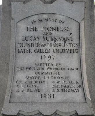
| 201 ► Ohio, Franklin County, Columbus, Franklinton — In This Churchyard — |
| Near North Davis Avenue at River Street, on the right when traveling north. | |||
| 202 ► Ohio, Franklin County, Columbus, Franklinton — Old Franklinton Cemetery — |
| On North Davis Avenue at River Street, on the right when traveling south on North Davis Avenue. | |||
| 203 ► Ohio, Franklin County, Columbus, Franklinton — Old Franklinton Cemetery Archaeology — Established 1799 — |
| Near River Street at North Davis Avenue, on the left when traveling east. | |||
| 204 ► Ohio, Franklin County, Columbus, Hilltop — 2260 Confederate Soldiers — |
| On Sullivant Avenue, on the right when traveling west. | |||
| 205 ► Ohio, Franklin County, Columbus, Hilltop — Camp Chase — The Historic National Road in Ohio — |
| On West Broad Street (Old National Road) (U.S. 40) west of South Roys Avenue, on the left when traveling west. | |||
| 206 ► Ohio, Franklin County, Columbus, Hilltop — 27-25 — Camp Chase — |
| On Sullivant Avenue at Chestershire Road, on the right when traveling west on Sullivant Avenue. | |||
| 207 ► Ohio, Franklin County, Columbus, Hilltop — Camp Chase Confederate Cemetery — |
| 208 ► Ohio, Franklin County, Columbus, Hilltop — Confederate Cannonball — |
| On Sullivant Avenue, on the right when traveling west. | |||
| 209 ► Ohio, Franklin County, Columbus, Hilltop — This Confederate Cemetery — |
| On Sullivant Avenue, on the left when traveling east. | |||
| 210 ► Ohio, Franklin County, Columbus, Indian Springs — Bill Moose — |
| On High Street near Indian Springs Dr., on the right when traveling north. | |||
| 211 ► Ohio, Franklin County, Columbus, Indian Springs — Philo Webster and Webster Graveyard — |
| On High Street at Indian Springs Dr., on the right when traveling north on High Street. | |||
| 212 ► Ohio, Franklin County, Columbus, Southwest Columbus — Our Unknown Dead — 1861-1865 — |
| 213 ► Ohio, Franklin County, Columbus, West Scioto — 109-25 — Campbell Memorial Park / The Adena Culture — |
| On McKinley Avenue, 0.5 miles south of Trabue Road, on the right when traveling south. | |||
| 214 ► Ohio, Franklin County, Columbus, West Scioto — Shrum Indian Mound — |
| On McKinley Avenue, 0.5 miles south of Trabue Road, on the right when traveling south. | |||
| 215 ► Ohio, Franklin County, Dublin — Dublin Cemetery Vaults — |
| On Bridge Street (Ohio Route 161) west of Franklin Street, on the left when traveling west. | |||
| 216 ► Ohio, Franklin County, Dublin — Indian Run Cemetery — |
| On West North Street at North High (Route 745), on the right when traveling west on West North Street. | |||
| 217 ► Ohio, Franklin County, Dublin — Leatherlips — |
| On Riverside Drive (Ohio Route 257) at Stratford Avenue, on the right when traveling north on Riverside Drive. | |||
| 218 ► Ohio, Franklin County, Gahanna, Moorfield — Mifflin Township Veterans Memorial — |
| 219 ► Ohio, Franklin County, Galloway — Sunset Cemetery Spanish-American War Memorial — |
| Near West Broad Street. | |||
| 220 ► Ohio, Franklin County, Galloway, Westchester-Green Countrie — 22-25 — Postle Family Cemetery — 1829-1870 — |
| On Gabriel's Run Drive at Gabriel's Landing Drive, on the left when traveling south on Gabriel's Run Drive. | |||
| 221 ► Ohio, Franklin County, Grove City — Grove City Cemetery Association — Founded 1908 — |
| 222 ► Ohio, Franklin County, Grove City, Woodlawn — 3306 Columbus Street — Est. 1853 — |
| On Columbus Street at Arbutus Avenue, on the right when traveling west on Columbus Street. | |||
| 223 ► Ohio, Franklin County, Groveport, South Columbus — 11-25 — Groveport Log House — |
| On Wilt Road, 0.1 miles west of Walnut Street, on the right when traveling east. | |||
| 224 ► Ohio, Franklin County, Groveport, South Columbus — 19-25 — John Rarey and "Cruiser" — |
| On Main Street, on the right when traveling east. | |||
| 225 ► Ohio, Franklin County, New Albany — 16-25 — Smith’s Burying Ground: Pioneer Cemetery — (Later called the "Burnside" Cemetery) — |
| On Johnstown Road (U.S. 62) north of New Albany Expressway (Ohio Route 161), on the left when traveling north. | |||
| 226 ► Ohio, Franklin County, New Albany, New Albany Links — 23-25 — Wagnor Cemetery — Pioneer Burial Ground & Site of First School in Plain Township — |
| On Central College Road (County Road 18) at Cedar Brook Drive, on the left when traveling east on Central College Road. | |||
| 227 ► Ohio, Franklin County, Upper Arlington — Bill Moose [Crowfoot] — |
| On Riverside Drive (U.S. 33), on the right when traveling north. | |||
| 228 ► Ohio, Franklin County, Westerville — Blendon Central Cemetery — |
| 229 ► Ohio, Franklin County, Westerville — Blendon Township War Memorial — |
| 230 ► Ohio, Franklin County, Westerville — Edward Phelps — |
| 231 ► Ohio, Franklin County, Westerville — Pioneer Cemetery Armed Forces Memorial — |
| 232 ► Ohio, Franklin County, Worthington, Old Worthington — 54-25 — Saint John's Church of Worthington and Parts Adjacent / Church and Graveyard — |
| On Dublin-Granville Road (Ohio Route 161) 0.1 miles east of High Street (U.S. 23), on the right when traveling east. | |||
| 233 ► Ohio, Fulton County, Archbold — Goll Cemetery — |
| On County Road F, 0.4 miles west of County Road 26, on the left when traveling west. | |||
| 234 ► Ohio, Fulton County, Delta — Delta Soldiers Memorial Monument — |
| Near Adrian Street north of Maplewood Street, on the left when traveling north. | |||
| 235 ► Ohio, Fulton County, Delta — Delta Unknown Dead Memorial — |
| On Adrian Street, on the left when traveling north. | |||
| 236 ► Ohio, Fulton County, Delta — International Underground Railroad Monument — |
| On Ohio Route 109 south of County Road F, on the right when traveling south. | |||
| 237 ► Ohio, Fulton County, Delta — John King and King Family Cemetery — |
| On Ohio Route 109 just south of County Road F, on the right when traveling south. | |||
| 238 ► Ohio, Fulton County, Delta — Reverend William King — 1812-1895 — |
| On Ohio Route 109 just south of Route F, on the right when traveling south. | |||
| 239 ► Ohio, Fulton County, Delta — Saint John's Evangelical Lutheran Church — |
| On County Route 4, on the left when traveling north. | |||
| 240 ► Ohio, Fulton County, Fayette — Fayette Veterans Memorial — |
| On Cemetery Street, on the left when traveling west. | |||
| 241 ► Ohio, Fulton County, Fayette — Pleasant View Union Civil War Memorial — |
| On Cemetery Street west of Maple Street, on the left when traveling west. | |||
| 242 ► Ohio, Fulton County, Lyons — Royalton Township Civil War Memorial — |
| Near West Morenci Street (Ohio Route 120) east of Bardden Street (County Route 11-1), on the right when traveling east. | |||
| 243 ► Ohio, Fulton County, Swanton — Swanton Township Veterans Memorial — |
| On Dodge Street, on the right when traveling west. | |||
| 244 ► Ohio, Fulton County, Wauseon — Nathaniel Leggett — First Person Buried In This Cemetery — 1862 — |
| On West Elm Street east of County Road 15-1, on the right when traveling east. | |||
| 245 ► Ohio, Fulton County, Winameg — Council Oak / Col. D.W.H. Howard — Chief Winameg - Col, D.W.H. Howard / Pioneer of Fulton County — |
| On County Road 102, on the left when traveling north. | |||
| 246 ► Ohio, Gallia County, Gallipolis — 4-27 — Hon. Samuel Finley Vinton — (1792 - 1862) — |
| On Pine Street (Ohio Route 160), on the right when traveling north. | |||
| 247 ► Ohio, Gallia County, Gallipolis — In Memoriam — |
| On Pine Street (Ohio Route 160), on the right when traveling north. | |||
| 248 ► Ohio, Gallia County, Gallipolis — 10-27 — Pine Street Colored Cemetery — |
| On Pine Street (Ohio Route 160), on the right when traveling south. | |||
| 249 ► Ohio, Geauga County, Burton — 14-28 — Welton Cemetery — |
| On Goodwin Street, 0.2 miles east of Cheshire Street, on the right when traveling west. | |||
| 250 ► Ohio, Greene County, Cedarville — Cedarville Civil War Monument — The Harper Memorial — |
| On Clifton Pike (Ohio Route 72) south of Varsity Drive, on the right when traveling south. | |||
| 251 ► Ohio, Greene County, Cedarville — Cedarville North Cemetery — National Historic Landmark — |
| On North Main Street (Route 72) 0.1 miles north of Alumni Drive, on the left when traveling north. | |||
| 252 ► Ohio, Greene County, Cedarville — In Grateful Remembrance — Williamson Mound — |
| Near Indian Mount Trail. | |||
| 253 ► Ohio, Greene County, Wilberforce — 20-29 — Martin Robison Delany — |
| On Brush Row Road west of U.S. 42, on the right when traveling west. | |||
| 254 ► Ohio, Greene County, Wilberforce — Stevenson Cemetery Gate — Massie Creek Scotch Associate Cemetery — |
| On Jones Road (County Route 86), on the right when traveling east. | |||
| 255 ► Ohio, Greene County, Wilberforce — Stevenson Cemetery Veterans Memorial — Massie Creek Scotch Associate Cemetery — |
| Near Jones Road (County Route 86). | |||
| 256 ► Ohio, Greene County, Xenia — 33-29 — Gowdy Associate Reformed Cemetery — |
| On East 3rd Street east of Sims Drive, on the right when traveling east. | |||
| 257 ► Ohio, Guernsey County, Cambridge — Founders Cemetery Pioneer Families — Cambridge, Ohio — |
| On Southgate Parkway (Ohio Route 209) at Turner Avenue, on the right when traveling north on Southgate Parkway. | |||
| 258 ► Ohio, Guernsey County, Cambridge — George R. Tingle — 1775 - 1830 — |
| On Bloomfield Road (Ohio Route 209) near Turner Avenue, on the right when traveling north. | |||
| 259 ► Ohio, Hamilton County, Camp Dennison — 28-31 — Waldschmidt Cemetery — Camp Dennison, Ohio — |
| On Lincoln Road just east of Glendale Milford Road (Ohio Route 126), on the right when traveling east. | |||
| 260 ► Ohio, Hamilton County, Cincinnati — 4-31 — The Church / The Founder — Salem United Methodist Church — United Methodist Church Registered Historic Site No. 267 — |
| On Salem Road. | |||
| 261 ► Ohio, Hamilton County, Cincinnati, Clifton — Clifton Jewish Cemetery — |
| On Old Ludlow Avenue, 0.1 miles north of Ludlow Avenue, on the right when traveling north. | |||
| 262 ► Ohio, Hamilton County, Cincinnati, East End — Columbia Baptist Cemetery / Columbia — First Settlement in Hamilton County — |
| On Wilmer Avenue. | |||
| 263 ► Ohio, Hamilton County, Cincinnati, East End — 89-31 — Columbia Presbyterian & Fulton Cemeteries / William Brown — |
| Near Ohio River Trail. | |||
| 264 ► Ohio, Hamilton County, Cincinnati, Northside — Spring Grove Cemetery — National Historic Landmark — |
| Near Spring Grove Avenue, 0.5 miles west of Mitchell Avenue, on the right when traveling west. | |||
| 265 ► Ohio, Hamilton County, Cincinnati, Northside — 53-31 — Spring Grove Cemetery & Arboretum — |
| Near Spring Grove Avenue,, 0.5 miles west of Mitchell Avenue, on the right when traveling west. | |||
| 266 ► Ohio, Hamilton County, Cincinnati, West End — 98-31 — Chestnut Street Cemetery / Two Centuries of Jewish Cincinnati — |
| On Central Avenue at Chestnut Street, on the left when traveling north on Central Avenue. | |||
| 267 ► Ohio, Hamilton County, Cincinnati, West End — The Oldest Jewish Cemetery West of the Allegheny Mountains — |
| On Central Avenue at West 12th Street, on the left when traveling north on Central Avenue. | |||
| 268 ► Ohio, Hamilton County, Cincinnati, West Price Hill — 48-31 — Powhatan Beaty / Union Baptist Cemetery — |
| Near Cleves Warsaw Pike, 0.2 miles west of Glenway Avenue (Ohio Route 264), on the left when traveling west. | |||
| 269 ► Ohio, Hamilton County, North Bend — Congress Green Cemetery / The Miami Purchase — William Henry Harrison Memorial Trail — |
| On Cliff Road, on the right when traveling north. | |||
| 270 ► Ohio, Hamilton County, North Bend — Death of a President — |
| On Cliff Road just north of Brower Road, on the right when traveling north. | |||
| 271 ► Ohio, Hamilton County, North Bend — 8- 31 — John Cleves Symmes — Congress Green Cemetery — Two Subjects, One Marker — |
| On Cliff Road, on the left when traveling north. | |||
| 272 ► Ohio, Hamilton County, Springdale, Parkdale — 70-31 — Old Saint Mary Cemetery — |
| On Springfield Pike (U.S. 4), on the right when traveling south. | |||
| 273 ► Ohio, Hancock County, Arlington — Veterans Memorial — American Legion Post 621 — |
| On Township Road (County Road 71) 0.5 miles north of West Main Cross Street (State Route 103), on the left when traveling north. | |||
| 274 ► Ohio, Hancock County, Arlington — Veterans Memorial — V.F.W. Post 4510 — |
| On Township Road (County Route 71) 0.5 miles north of West Main Cross Street (Ohio Route 103), on the left when traveling north. | |||
| 275 ► Ohio, Hancock County, Benton Ridge — Schwartz Cemetery Veterans Memorial — |
| On Local Highway 132, 0.1 miles north of Local Highway 89, on the right when traveling north. | |||
| 276 ► Ohio, Hancock County, Findlay — Hancock County Civil War Memorial — |
| Near West Main Cross Street east of Interstate 75, on the right when traveling west. | |||
| 277 ► Ohio, Hancock County, Findlay — Hancock County Civil War Memorial — |
| Near West Main Cross Street (Ohio Route 12) east of Interstate 75, on the left when traveling east. | |||
| 278 ► Ohio, Hancock County, Findlay — Indian Green Cemetery Veterans Memorial — |
| Near U.S. 224, 0.1 miles west of Ohio Route 186, on the left when traveling west. | |||
| 279 ► Ohio, Hancock County, Findlay — Tell Taylors Is Buried In The Family Plot — Tell Taylor Memorial — |
| Near McManness Avenue south of Cherry Street, on the right when traveling north. | |||
| 280 ► Ohio, Hancock County, Fostoria, Washington Township — Fostoria Civil War Memorial — |
| On Van Buren Street west of River Street, on the right when traveling west. | |||
| 281 ► Ohio, Hancock County, McComb — McComb Civil War Memorial — |
| On West Main Street west of Rader Road, on the right when traveling west. | |||
| 282 ► Ohio, Hardin County, Kenton — 8-33 — Fort McArthur Cemetery — |
| On Lynn Valley Pike, 0.2 miles south of County Route 106, on the left when traveling south. | |||
| 283 ► Ohio, Hardin County, Kenton — Hardin County Ohio Civil War Soldier Monument — GAR and WRC — |
| Near Ohio Route 309 at Jacob Parrot Road (County Route 171), on the left when traveling east. | |||
| 284 ► Ohio, Hardin County, Kenton — 2-33 — Jacob Parrott — |
| On Ohio Route 309 east of Jacob Parrot Rd. (Ohio Route 171), on the right when traveling west. | |||
| 285 ► Ohio, Hardin County, Kenton — Pioneer Cemetery — |
| On East Franklin Street, on the right when traveling east. | |||
| 286 ► Ohio, Harrison County, Cadiz — Cadiz G.A.R. Memorial — |
| Near Charleston Street, 0.3 miles east of U.S. 250, on the right when traveling east. | |||
| 287 ► Ohio, Harrison County, Deersville — Tappan — |
| On U.S. 250, 0.2 miles east of Local Highway 215, on the right when traveling east. | |||
| 288 ► Ohio, Henry County, Colton — Heath-Colton G.A.R. Civil War Memorial — |
| On County Route 4 at County Route V, on the right when traveling north on County Route 4. | |||
| 289 ► Ohio, Henry County, McClure — Olive Branch Cemetery — |
| On County Road 5A, 0.2 miles south of County Road P, on the left when traveling north. | |||
| 290 ► Ohio, Henry County, Napoleon — Building the Church — Saint Paul's Lutheran Church — |
| On County Road 17 at County Road Q1, on the left when traveling north on County Road 17. | |||
| 291 ► Ohio, Henry County, Napoleon — First Bell and New Foundation — Saint Paul's Lutheran Church — |
| On County Road 17 at County Road Q, on the left when traveling north on County Road 17. | |||
| 292 ► Ohio, Henry County, Napoleon — Glenwood Memorial — |
| On Glenwood Avenue, on the left when traveling north. | |||
| 293 ► Ohio, Henry County, Napoleon — 5-35 — Miami & Erie Canal And Napoleon's First Cemetery — |
| On East Riverview Avenue (Route 424) just north of East Clinton Street, on the left when traveling east. | |||
| 294 ► Ohio, Henry County, Napoleon — Site of Zion Lutheran Church and Cemetery — |
| On County Road Q1, 0.4 miles west of County Road 18, on the right when traveling west. | |||
| 295 ► Ohio, Henry County, Napoleon — The Parish School — Saint Paul's Lutheran Church — |
| On County Route 17 east of County Route Q, on the right when traveling north. | |||
| 296 ► Ohio, Henry County, Texas — Texas Veterans Memorial — |
| On County Road 4A at County Road S, on the right when traveling north on County Road 4A. | |||
| 297 ► Ohio, Highland County, Greenfield — Greenfield Civil War Monument — James H. Freshour — |
| Near North Washington Street (Ohio Route 41) north of Massie Street, on the right when traveling north. | |||
| 298 ► Ohio, Highland County, Hillsboro — Highland County Revolution War Memorial — |
| On North High Street at West Main Street (Ohio Route 73), on the left when traveling north on North High Street. | |||
| 299 ► Ohio, Highland County, Sinking Spring — Governor Charles Willing Byrd — |
| On Washington Street at Grant Ct., on the left when traveling west on Washington Street. | |||
| 300 ► Ohio, Holmes County, Calmoutier — 2-38 — Calmoutier — |
| On County Road 229, on the left when traveling east. | |||
532 entries matched your criteria. Entries 201 through 300 are listed above. ⊲ Previous 100 — Next 100 ⊳