Father Tolton, the first negro priest in the United States, was born of slave parents in Brush Creek, Missouri, in 1854. Educated at Quincy schools, he returned to this city after his ordination in Rome, Italy, in 1886. He celebrated his first . . . — — Map (db m58799) HM
On 4th Street (Illinois Route 57) at Maine Street (U.S. 24), on the left when traveling north on 4th Street.
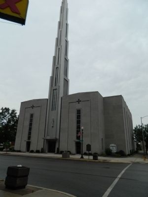
First United Presbyterian Church, 1879
8th & Broadway
Gothic Revival Style
Robert Bunce, Architect
Churches usually have an elaborate entrance or portico
to mark the transition into a religious dwelling.
The three portals symbolize the . . . — — Map (db m156776) HM
On Maine Street west of 7th Street, on the right when traveling west.
From October 8-10, 1838, more than 800 Potawatomi Indians were encamped here in Quincy, Illinois and directly across the Mississippi River in Missouri. They were being forced to march from Southern Michigan and Northern Indiana to Eastern Kansas . . . — — Map (db m150021) HM
On Quinsippi Island Road, on the right when traveling east.
From 1818 through 1851 groups of American Indians were forcibly removed from states on the east side of the Mississippi River to territories on the west side. One of these removals was the Potawatomi Trail of Death, conducted by William Polke, . . . — — Map (db m181375) HM
Near Maine Street (U.S. 24) just west of 4th Street (Illinois Route 57), on the left when traveling west.
First United Presbyterian Church, 1879
8th & Broadway
Gothic Revival Style
Robert Bunce, Architect
The majority of churches built in Quincy in the 19th century revived a European Gothic style with pointed arches over the entrance and . . . — — Map (db m150586) HM
On Maine Street just east of 8th Street, on the right when traveling east.
On this corner, in 1859, the Franciscan Fathers founded St. Francis Solanus College. In September of 1860, the College was relocated on Allstynes Prairie (the present site) at 19th and College Avenue. The charter was granted by the State of Illinois . . . — — Map (db m150020) HM
On Maine Street at 8th Street, on the right when traveling east on Maine Street.
Founded in 1839 to serve the Irish Catholics of Quincy. Here runaway slave Augustine Tolton attended school, was confirmed and worked until he entered the seminary and became the first negro priest in the United States. — — Map (db m150019) HM
"His name fills the nation; and is not unknown, even in foreign lands" (A. Lincoln, 1856). Stephen A. Douglas, a Jacksonian Democrat, arrived in Quincy in 1841, at twenty-seven the youngest Supreme Court Judge in Illinois history. In . . . — — Map (db m150024) HM
On South 4th Street (Route 57) just south of Maine Street (U.S. 24), on the left when traveling north.
First United Presbyterian Church, 1879
8th & Broadway
Gothic Revival Style
Robert Bunce, Architect
Construction began in May, 1875, but stalled when a violent storm collapsed the walls of the new church. Calamity struck again when fire . . . — — Map (db m150591) HM
On All American Park north of Hampshire Street, on the left when traveling north.
In 1839, the Latter-Day Saints crossed the Mississippi River at this approximate site and were befriended by the citizens of Quincy.
(Reverse:)
"The citizens of Quincy (will) be held in everlasting remembrance for their unparalleled . . . — — Map (db m150451) HM
On South 4th Street (Illinois Route 57) just south of Maine Street (U.S. 24), on the left when traveling north.
Here on December 4, 1830 the first organized congregation in Quincy was established by the Reverend Asa Turner, one of seven Yale theological students, known as the "Yale Band," who pledge to save the "west" for Christ by founding churches and . . . — — Map (db m150025) HM
Near Quinsippi Island Road west of Bonansinga Drive.
The Lord's Cabin is dedicated to the glory of God, the use for all God's people and in memory of Sir Knight Norbert H. (Bert) Wensing. (1928-1977)
It was dedicated November 5, 1977, by the most Reverend Joseph A. McNicholas, D.D., Bishop of . . . — — Map (db m187250) HM
On Maine Street east of North 4th Street (U.S. 24), on the right when traveling west.
Mormons in Missouri were forced to flee their homes or face death because of an "extermination order" issued in 1838 by Governor Lillburn Boggs. Many of them crossed into Illinois at Quincy and were made welcome by the people here. In April 1839 . . . — — Map (db m149828) HM
On Miller City Road, 2 miles south of Illinois Route 3 when traveling south.
The church, founded by Rev. Nathan London in 1882, was located near this section of road. The cornerstone, unearthed a few yards west, was donated by his family to the Cairo custom house. — — Map (db m40409) HM
On East Peru Street (U.S. 6), on the right when traveling west.
This two-story frame structure was the home of abolitionist Owen Lovejoy, who was born in Maine in 1811. Lovejoy moved into the house in 1838, when he became a Congregationalist minister. He was leader in the formation of the Republican Party in . . . — — Map (db m44351) HM
On 1st Street at East Park Street, on the left when traveling north on 1st Street.
The First Congregational Church, built in 1855-56, was popularly known as the “Goose Pond” Church, because the site was once a water-filled area, home to flocks of wild geese and ducks. The church became a meeting center for numerous . . . — — Map (db m31118) HM
On County Route 300N, 0.2 miles east of County Route 2100E, on the left when traveling east.
Services for this congregation began in 1870 in the Fairview schoolhouse one mile west, on the N.E. corner. The congregation was organized on October 29, 1876. This site for the first church, 208' x 209', was donated on January 11, 1877 by Claus and . . . — — Map (db m89254) HM
On South Mathews Avenue at West Oregon Street, on the left when traveling south on South Mathews Avenue.
The Channing-Murray Foundation, originally established in 1908 as the Unitarian Church of Urbana, was placed on the National Register of Historic Places May 13, 1991 by the United States Department of the Interior. — — Map (db m225573) HM
On West Green Street near South Birch Street, on the left when traveling west.
The need to repair or replace the original Universalist Church building, built in 1871 at the corner of Green and Birch Streets in Urbana, was discussed at the annual meeting of the Church Board on January 15, 1913. The Reverend E. V. Stevens . . . — — Map (db m226009) HM
On North Central Avenue (Illinois Route 49) at East Alabama Avenue, on the right when traveling north on North Central Avenue.
With gratitude to all the workers, for the children of tomorrow, we raise this bell to the glory of God: in the love of holiness, and to the cause and just pursuit of freedom.
This 48-inch, 2000-pound bell was part of the original United . . . — — Map (db m184622) HM
Near North 10th Street north of East Alabama Avenue, on the right when traveling north.
With the completion of the National Road (Cumberland Road) through Clark County in 1834, a settlement known as Cumberland was established in this vicinity. The settlement consisted mainly of workmen who moved here for the purpose of securing . . . — — Map (db m188290) HM
On West Lincoln Street (County Route 31) at South Fulton Street, on the right when traveling west on West Lincoln Street.
For more than fifty years Westfield College was located on this site. It was founded as a seminary in 1861 by the United Brethren in Christ and incorporated as a college in 1865. The school was coeducational from the beginning and in some years . . . — — Map (db m184588) HM
On Germantown Road (County Route 7) south of County Road 1200 N, on the right when traveling south.
In 1832 cholera plagued this area
Entire families were wiped out,
Sometimes over night
Jos Altepeter made a covenant
with his maker, if his large family
was spared he would erect
A large cross on his farm
near the public road as a . . . — — Map (db m162241) HM
On North 14th Street at Charleston Avenue, on the right when traveling north on North 14th Street.
Site of the Cumberland Presbyterian Church
constructed 1859, reconstructed 1895 with elements of the old building included.
In 1863, the church basement was used as a Civil War hospital. Mattoon served as an exchange point for soldiers on . . . — — Map (db m188425) HM
To summon the people of Bellwood to worship God and to strive for education
1908
St. John Lutheran Church and School
Placed here in honor of the nation's bicentennial
1976 — — Map (db m245033) HM
Near Euclid Avenue just south of 14th Street, on the right when traveling north.
In celebration of the 50th anniversary of St. Mary of Celle Little League we dedicate this plaque in memory of its founder Father Robert Mastny — — Map (db m234701) HM
On North Marmora Avenue, 0.1 miles south of Belmont Avenue, on the left when traveling north.
They gave their all—may God have mercy on their souls
Raymond Baker • Robert Berghauser • Mary Blasi • Leon Boeykens • John T. Budny • Henry Conley • William J. Connell, Jr. • John Coyne • Robert Cunningham • Donald Freimuth • Michael Gallagher . . . — — Map (db m248244) WM
Near South Indiana Avenue near East 33rd Boulevard.
Pilgrim Baptist Church
Adler and Sullivan, Architects
1891
The decorative and planning skills of Sullivan and the engineering ability of Adler are embodied in the strong masonry forms of this building, embellished with terra-cotta . . . — — Map (db m189477) HM
On North Narragansett Avenue, 0.1 miles north of West Addison Street, on the left when traveling north.
In memory of
Henry Horner
1878 – 1940
Judge of the Probate Court of Cook County
1914 – 1933
Governor State of Illinois
1933 – 1940
He Had Clean Hands And A Pure Heart — — Map (db m246005) HM
On West Jackson Boulevard at South Albany Avenue, on the left when traveling west on West Jackson Boulevard.
Erected in honor of
Our Sorrowful Mother
by
the Novenites of Chicago
The first Novena devotion
was held here on
January 8, 1937
Blessed on the feast of
Our Sorrowful Mother
September 20, 1942
Mother of Sorrows
pray for . . . — — Map (db m244572) HM
On North Elston Avenue at North La Crosse Avenue, on the right when traveling north on North Elston Avenue.
This memorial spire and cross is erected to the Glory of God in salutary tribute to the memory of our founders and to all who have dedicated themselves to the mission of this church upon its 75th anniversary.
On October 8, 1893, our pioneer . . . — — Map (db m136423) HM
On North Dearborn Parkway north of Schiller Street.
Chester H. Walcott, architect
Bennett, Parsons & Frost
consulting architects
awarded
the Lake Shore Trust & Savings Bank's
Gold Medal
for the most beautiful remodeled building
by the jury of the Chicago chapter,
American Institute of . . . — — Map (db m242577) HM
On South Vincennes Avenue near East 45th Street, on the right when traveling north.
Ebenezer Missionary Baptist Church
(Originally, Isaiah Temple)
Dankmar Adler, architect
1898-99
Built as one of Chicago's early Reform Judaism synagogues, this
Classical Revivial-style building is the last building designed by
famed . . . — — Map (db m188631) HM
On South Greenwood Avenue near East 46th Street, on the right when traveling south.
Kenwood United Church of Christ
William. W. Boyington and Henry B. Wheelock,
architects
1887-88
This Richardsonian Romanesque-style church building is
a textbook example of this medieval-influenced style, popular in
the late nineteenth . . . — — Map (db m188566) HM
On North Recreation Drive near West Addison Drive, on the right when traveling north.
Kwanusila, the Thunderbird, is an authentic Kwagulth Indian totem pole, carved in red cedar by Tony Hunt of Port Rupert, British Columbia.
The crests carved upon the totem pole represent Kwanusila, the Thunderbird, a whale with a man on its . . . — — Map (db m94404) HM
On North Halsted Street south of West Addison Street, on the left when traveling north.
Fr. Mychal Judge
"The Saint of 9/11"
(1933 - 2001)
"Lord, take me where you want me to go. Let me meet who you want me to meet. Tell me
what you want me to say. And keep me out of your way."
– Fr. Mychal Judge
Fr. . . . — — Map (db m182060) HM
On North Lakeview Avenue at West St. James Place, on the right when traveling south on North Lakeview Avenue.
Mother Frances Xavier Cabrini
Catholic nun, founder of religious and social institutions
1850 - 1917
Mother Frances Cabrini was the first American declared a saint
by the Catholic Church. She was recognized for her tireless
work . . . — — Map (db m187989) HM
Born Nov. 4, 1819
in Bavaria, Germany.
Died July 28, 1883
in Chicago, Ill.
A pioneer of German Methodism
in the Northwest; a member of the
Chicago Methodist Conference,
and for 41 yrs. a faithful
Minister of the Gospel
of Jesus . . . — — Map (db m94346) HM
On West Cabrini Street just west of Racine Ave., on the right when traveling west.
Saint Frances Xavier Cabrini was the first United States citizen canonized a Saint. In this building which bore her name, Mother Cabrini cared for the many Italian Immigrants who settled in this area of the near west side.
In her honor
and . . . — — Map (db m98892) HM
On North La Salle Drive at West Superior Street, on the right when traveling north on North La Salle Drive.
The St. Vincent Center has played a prominent and unique role in the life-affirming, charitable history of the Catholic Archdiocese of Chicago.
In 1881, the St. Vincent Hospital and Infant Asylum, popularly known as St. Vincent's Orphanage, . . . — — Map (db m238137) HM
On North Wells Street, on the right when traveling south.
The churches of Old Town reflect the
community's early history. German immigrants
established St. Joseph's Parish in 1846 at
1107 North Orleans. In 1852, Michael Diversey,
a prominent member of St. Joseph's Parish,
donated land at North Avenue . . . — — Map (db m188264) HM
On South Wabash Avenue at East 24th Street, on the right when traveling south on South Wabash Avenue.
Quinn Chapel
1892
This church houses the oldest black congregation
in Chicago, tracing its origins back to 1844. Members
of the congregation have played a significant role tn
the development of the city since that time. The
church is a . . . — — Map (db m189237) HM
On South Michigan Avenue at East Cullerton Street on South Michigan Avenue.
Rebuilt in 1900 by Howard Van Doren Shaw
When this neo-Gothic church was designed by a prominent New York architect, the surrounding streets, including Prairie Avenue one block east, were lined with the homes of wealthy Chicagoans. The fine . . . — — Map (db m121834) HM
On West Jackson Boulevard east of Ashland Avenue, on the right when traveling east.
These two blocks are virtually all that remain of Chicago's once-fashionable Near West Side of the 19th century. Most of the residences, as well as the Romanesque Revival-style Church of the
Epiphany, date from the 1880s and 1890s. — — Map (db m242527) HM
On Laflin Street at Jackson Boulevard, on the right when traveling south on Laflin Street.
These two blocks are virtually all that remain of Chicago's once-fashionable Near West Side of the 19th century. Most of the residences, as well as the Romanesque Revival-style Church of the Epiphany, date from the 1880s and 1890s. — — Map (db m242531) HM
On Adams Street (U.S. 66) west of Laflin Street, on the left when traveling west.
These two blocks are virtually all that remain of Chicago's once-fashionable Near West Side of the 19th century. Most of the residences, as well as the Romanesque Revival-style Church of the Epiphany, date from the 1880s and 1890s. — — Map (db m242535) HM
On North Central Avenue north of West Berteau Avenue, on the right when traveling north.
[Center panel:]
We owe so much to so few
Dedicated in memory of the Romanian
Americans, who in the spirit of
loyalty, made the supreme sacrifice
in World War II
Pfc. George Gherghescu Jr. U.S.A., Co. B 11TH Eng. Combat Bn., April 27, . . . — — Map (db m242951) WM
On East Chicago Avenue at North Wabash Avenue, on the right when traveling west on East Chicago Avenue.
This rare surviving example of Victorian Gothic design is also one of the city's best late-19th century apartment buildings. Because early luxury apartments were viewed with skepticism, this building was designed to look like a series of four . . . — — Map (db m66612) HM
On South Indiana Avenue at East 84th Street, on the left when traveling north on South Indiana Avenue.
Mahalia Jackson
Gospel singer
1911 - 1972
One of thousands of black Southerners to move north
during the Great Migration, Mahalia Jackson arrived in
Chicago in 1927, bringing with her the rich tradition of
New Orleans gospel . . . — — Map (db m188245) HM
On South Indiana Avenue north of East 80th Street, on the left when traveling south.
Thomas A. Dorsey
Musician
1899 - 1993
The “father of gospel music,” Thomas Dorsey mixed jazz, blues
and spirituals to create a new musical genre. Composer, publisher
and promoter, he toured the United States with legends
Mahalia . . . — — Map (db m188247) HM
On South Clark Street at West Jackson Blvd (U.S. 66), on the right when traveling north on South Clark Street.
On this site stood, in 1851, the
first Jewish house of worship
in the State of Illinois
and the middle Northwest.
Kehlath Anshe Mayriv
Congregation Men of the West
Now known as K.A.M. Temple
Established 1847
Dedicated by the
Jewish . . . — — Map (db m134416) HM
On East Madison Street at South Wabash Avenue, on the left when traveling west on East Madison Street.
Here stood Old Saint Mary’s Cathedral. Church of the first five Catholic bishops of Chicago-quarter, Van de Velde, O’Regan, Duggan, Foley. Opened for divine service December 25, 1843. Destroyed in the great fire of October 8-9, 1871 — — Map (db m223808) HM
On this site, Sept. 23, 1846, the
Sisters of Mercy
who provided Chicago with its first hospital, began their charitable, educational and civic services to this city — — Map (db m99817) HM
On Leavitt Street at West Haddon Avenue, on the left when traveling south on Leavitt Street.
Designed to resemble the Russian provincial churches known to its first parishioners, this church and its rectory are symbolic of the Russian Orthodox community in Chicago. The ideologies of client and architect harmonized well in this project, . . . — — Map (db m234568) HM
On West Cortez Street near North Oakley Boulevard.
This well-preserved collection of workers cottages, single-family houses, Chicago-style flat buildings, and small apartments form a distinctive residential streetscape that tells the story of German, Polish, and, ultimately, Ukrainian immigrants who . . . — — Map (db m234581) HM
On West Adams Street at Des Plaines Street, on the right when traveling north on West Adams Street.
This property has been
placed on the the
National Register
of Historic Places
by the United States
Department of Interior
St. Patrick's Churchconstructed during the period 1852 to 1856 St. Patrick's is the oldest church building . . . — — Map (db m99770) HM
On 15th Street east of 50th Avenue, on the right when traveling east.
[The top of the marker, in Lithuanian:]
Lietuvos valstybės atkurimo 50.metis sukakciai pamineti
[The bottom of the marker, in English:]
To commemorate the 50th anniversary of the restoration of Lithuania's independence — — Map (db m244737) HM WM
On 24th Street west of 53rd Avenue, on the right when traveling east.
Mary Queen of Heaven Parish was founded in 1911 when more than 100 families of Czech descent living in the middle of Cicero petitioned the Archdiocese of Chicago for a new church.
A building on the northwest corner of 24th Place and 53rd Avenue . . . — — Map (db m245075) HM
On Rev. Morrison Boulevard, 0.1 miles east of W Elk Grove Village Boulevard, on the right when traveling west.
In Recognition of
The Reverend J. Ward Morrison
Pastor Emeritus
Queen of the Rosary Parish
Elk Grove Village, Illinois
This Boulevard is named in honor of the Reverend J. Ward Morrison. He devoted much of his time, energies and talents . . . — — Map (db m10672) HM
On Harrison Street at Elgin Avenue, on the right when traveling east on Harrison Street.
Saint Bernardine
parishioners
who made the
supreme sacrifice
during World War II
Honor Roll
Frank Conlon
Edward Csech
Richard Danca
August Demma
Edward Downey
Robert Foitag
Fred Obermayer
William Parichy . . . — — Map (db m227667) WM
Near North Hillside Avenue, 0.1 miles north of Butterfield Road (Illinois Route 56), on the right when traveling north.
"Mater Dolorosa" is Latin for Mother of Sorrows
Order of the Servants of Mary (O.S.M.)
The original building and 19 acre site were dedicated in 1926 to serve as a seminary for the Order of the Servants of Mary. Operations as a seminary ceased . . . — — Map (db m247717) HM
Near Roosevelt Road (Illinois Route 38) 0.2 miles west of South Wolf Road, on the right when traveling west.
Consecrated on August 30, 1900 by Archbishop Patrick Feehan, Mt. Carmel Cemetery became the first cemetery to be opened in the western area of the Archdiocese. Initially, Mt. Carmel operated its own railroad connection directly from Chicago for . . . — — Map (db m246682) HM
On Harrison Street south of Hillside Avenue, on the right when traveling east.
Consecrated on August 30, 1900 by Archbishop Patrick Feehan, Mt. Carmel Cemetery became the first cemetery to be opened in the western area of the Archdiocese. Initially, Mt. Carmel operated its own railroad connection directly from Chicago for . . . — — Map (db m247668) HM
On Roosevelt Road (Illinois Route 38) 0.7 miles west of Mannheim Road (U.S. 12/45), on the right when traveling east.
Jewish War Veterans of the United States — Department of Illinois
To all who served our country at home or on foreign soil
May they rest in peace
Yarmo ☆ DeVere
Post No. 469
Department of Illinois
In memoriam
Commemorative . . . — — Map (db m245291) WM
Near South Wolf Road, 0.3 miles south of Roosevelt Road (Illinois Route 38), on the right when traveling west.
Consecrated on September 14th, 1947 by Samuel Cardinal Stritch, Queen of Heaven Cemetery opened as a successor to Mount Carmel Cemetery, located across Roosevelt Road. Queen of Heaven paved the way as a "modern" cemetery with the introduction of . . . — — Map (db m245313) HM
On Roosevelt Road, 0.6 miles east of Tri-State Tollway (Interstate 294), on the right when traveling east.
Consecrated on September 14th, 1947 by Samuel Cardinal Stritch, Queen of Heaven Cemetery opened as a successor to Mount Carmel Cemetery, located across Roosevelt Road. Queen of Heaven paved the way as a "modern" cemetery with the introduction of . . . — — Map (db m246699) HM
Near Roosevelt Road (Route 38) 0.8 miles west of Wolf Road, on the left when traveling west.
I can do all things through him who strengthens me.
Philippians 4:13
[Text on left side of memorial:]
Mother Cabrini was born in Sant Angelo, Lombardy, Italy, July 15,1850. She founded the Institute of the Missionary . . . — — Map (db m248045) HM
Near Roosevelt Road (Route 38) 0.4 miles east of Tri-State Tollway (Interstate 294), on the right when traveling east.
Born 825 – Died 884
Feast Day July 7
Brother of St. Cyril
Archbishop of Sirmium and Apostolic Legate
[Etched at the base of the sculpture:]
Apostle of the Slavs
St. Methodius, our holy patron, who led our forefathers . . . — — Map (db m248036) HM
On South Wolf Road, 0.4 miles south of Roosevelt Road (Illinois Route 38).
St. Charles Borromeo
1538–1584
The Pious Society of the Fathers of St. Charles was founded in 1887 by Bishop J.B. Scalabrini for the assistance to the Italians throughout the world. It's members are working in Europe, North and South America and . . . — — Map (db m245316) HM
Near Roosevelt Road (Illinois Route 38) 0.2 miles east of Tri-State Tollway (Interstate 294), on the right when traveling east.
[Text of crest in Latin at the top:]
Pax Christi regnat super vos
[Text of crest translated into English:]
The peace of Christ reigns over you
[Text in Slovak below the crest:]
Ja som život kto veri vo mne bars by aj zomrel
žit bude . . . — — Map (db m247681) WM
Near Roosevelt Road (Illinois Route 38) 0.8 miles Wolf Road.
Let all that you do, be done in charity.
I Cor. 16:14
How much preparation does it take to become a saint? This frail woman—contemplative, author, adviser to Popes, spiritual comforter to thousands of people—lived many . . . — — Map (db m248053) HM
On Roosevelt Road (Illinois Route 38) 0.4 miles Tri-State Tollway (Interstate 294).
Born 827 – Died 869
Feast Day July 7
Brother of St. Methodius
Creator of the Slavonic Alphabet, Philosopher and Linguist
[Etched at the base of the sculpture:]
Apostle of the Slavs
Humbly do we thank our Heavenly Father . . . — — Map (db m248039) HM
On Oak Street near 1st Avenue, on the right when traveling west.
In memoriam
2nd Lt. Benjamin R.
Morin, S.J.
1920 -- 2015
Maywood's warrior priest
The first U.S. tank commander to
engage enemy forces in World War II
on the Bataan Peninsula
— — Map (db m227960) HM WM
On Westgate Street, 0.1 miles east of Harlem Avenue (Illinois Route 43), on the right when traveling west.
This plaque commemorates and honors the strength and courage of Black Oak Park residents who established and built Mount Carmel Baptist Church at this location in 1905, which stood until 1930. Originally, the Church had purchased a property on . . . — — Map (db m241199) HM
On South East Avenue at Van Buren Street, on the right when traveling south on South East Avenue.
†
John & Cecilia Brennan have erected
this image of Our Blessed Lady
in loving memory of their beloved son
Staff Sargeant John Thomas Brennan
who was born on the 9th of April 1920,
was mortally wounded in combat
on the 14th of January . . . — — Map (db m234196) WM
On Kenilworth Avenue just south of Lake Street, on the right when traveling north.
In 1905, the Unity Church of Oak Park, home to a Universalist congregation, was struck by lightning and burned to the ground. The congregation commissioned Frank Lloyd Wright to design a new building for them.
Wright's bold design with its . . . — — Map (db m227636) HM
On Lake Street, 0.1 miles east of Kenilworth Avenue, on the right when traveling east.
Unity Temple, as part of the 20th-century architecture of Frank Lloyd Wright, has been inscribed on the World Heritage List.
Inscription confirms that this property deserves protection for the benefit of all humanity because of its . . . — — Map (db m227931) HM
On Thatcher Avenue near Belmont Avenue, on the right when traveling south.
[South-facing, western tablet:]
Matthew, a Galilean tax-collector and one of the twelve apostles, was the author of the first Gospel, which he wrote in his native Aramaic for the Jews of his time, probably around 42 A.D. After preaching in . . . — — Map (db m245108) HM
Near West Belmont Avenue west of Thatcher Avenue, on the right when traveling east.
Consecrated on August 28, 1904 by Archbishop Quigley, St. Joseph Cemetery was opened by the German Angel Guardian Society as a replacement for Saint Boniface Cemetery.
When the gates opened, St Joseph's became one of the largest and most active . . . — — Map (db m245105) HM
We are Assyrians
In God we trust
Lachen — Hormis
This memorial is erected to the greater and honor of God and in remembrance of the descendants of the great Assyrian and Babylonian Empires, known to the world as the
Garden of Eden . . . — — Map (db m245888) HM
On Niles Center Road at Galitz Street, on the left when traveling north on Niles Center Road.
Father Arthur R. Sauer has spent 34 years as a civic leader in Skokie, tenaciously working to make the village a better place to live.
As pastor of St. Peter's Parish, he developed exceptional school programs which won national awards. As a . . . — — Map (db m242974) HM
[Plaque in front of the statue:]
This monument has been erected as a lasting memorial to all victims of Nazism and will remain in perpetuity as a reminder what hate can do to mankind, if decent people are not vigilant to forestall such a calamity . . . — — Map (db m243019) HM WM
Near South Oak Park Avenue, 0.3 miles south of 41st Street.
A three ton ravaccione marble panel, one of four in the world which contains the face of Christ in reverse relief, was dedicated October 25, 1991.
Weighing over six thousand pounds the marble sculpture measures 8 feet 6 inches tall and 4 feet 6 . . . — — Map (db m247359) HM
Near Archer Avenue (Illinois Route 171) east of Kingery Highway (Illinois Route 83), on the right when traveling east.
St. James at Sag Bridge Church & Cemetery. Listed on the National Register of Historic Places. Parish founded 1833. Present church built 1853 — — Map (db m203578) HM
Near Linden Avenue, 0.1 miles west of Sheridan Avenue, on the right when traveling west.
The piece of ornamental concrete to your left features a nine-pointed star, a symbol of the Baha'i Faith. It was produced in the 1920s to test how a newly developed system of precast concrete panels would perform in Chicago's extreme weather. The . . . — — Map (db m126788) HM
On South Lincoln Street just south of East Walnut Street, on the right when traveling north.
Former Nuns of St. Elizabeth Church, Robinson, Illinois
Sr. Naomi Libiak, Dc 1978-1981 • Sr. Gaynelle Barrett, Dc 1978-1985 • Sr. Mary Dupont, Dc 1981-1987 • Sr. Catherine Mary Norris, Dc 1981 • Sr. Annina Bullock, Dc 1987-1994 • Sr. Rita . . . — — Map (db m229851) HM
Near East Woodlawn Street east of North Monroe Street, on the left when traveling east.
During the twenty years Abraham Lincoln attended the DeWitt County Court on the Eighth Judicial Circuit, he and Clifton H. Moore, Clinton’s first resident attorney, developed a deep friendship as well as a mutual law practice.
The two men . . . — — Map (db m24298) HM
288 entries matched your criteria. The first 100 are listed above. Next 100 ⊳