On North Michigan Avenue just north of Atlantic Avenue, on the right when traveling north.
"I walked with a limp for six years. Then five years ago, when I was 17, my parents took me to a healing service. That meeting changed my life!…Yes, I believe in miracles. My being Miss America is proof that miracles do still happen. Nothing can . . . — — Map (db m153544) HM
On Baltic Avenue at North Ohio Avenue, on the right when traveling west on Baltic Avenue.
An Atlantic City native, Davis graduated from the New Jersey College of Commerce and is a veteran of World War II. He served as Assistant Vice-President at Atlantic National Bank and Deputy Director of Administration at the Atlantic City . . . — — Map (db m153456) HM
On Atlantic Avenue at North Mississippi Avenue, on the right when traveling west on Atlantic Avenue.
At the age of just 28, Father John Quaremba, a native of Castle Grande, Italy, founded St. Michael's Church in Atlantic City for Italian immigrants. In September 1904 he celebrated the first Mass at St. Michael's Parish which was just two years . . . — — Map (db m190924) HM
On Atlantic Avenue just east of South Michigan Avenue, on the right when traveling east.
A native of Atlantic City graduated with honors as a pre-med student at Lincoln University in Chester County Pa. While completing his studies at Howard University School of Medicine in Washington D.C., Doggett was the recipient of several scholastic . . . — — Map (db m190927) HM
On North Michigan Avenue just north of Atlantic Avenue, on the left when traveling north.
"As a child growing up singing and dancing in my parent' school… I have always felt loved. Even before I was a Rockette at Radio City Music Hall at age 18, or Miss America 1962 at age 19. After the birth of my two children, Robyn and Jim, I began . . . — — Map (db m153476) HM
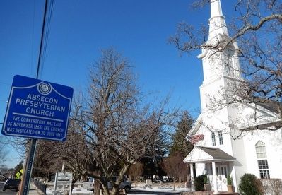
On North Michigan Avenue just north of Atlantic Avenue.
When asked about the so-called Now Generation Vonda Key replied, "Some of their demands are no doubt justified…but many do the things they do just to be spectacular. Sure they have some legitimate gripes. But why not approach the problem . . . — — Map (db m153473) HM
On North Ohio Avenue just west of Gramercy Avenue, on the right when traveling west.
Born in Clinton, North Carolina, Wilbert Royal made Atlantic City his home after receiving his Master's Degree at North Carolina A&T University. Affectionately known as "Huff", he spent many summers in Atlantic City working as a bellhop at Lombardy . . . — — Map (db m190941) HM
On Walkers Forge Road at Maple Avenue on Walkers Forge Road.
The Estellville Methodist Church, formerly Stephen Creek Meeting House, was built in 1834 at a cost of $621.21 on land donated by John E. Estell of, at that time, Weymouth Township, Gloucester County.
The Society was incorporated on December 10, . . . — — Map (db m213390) HM
(Top marker) Society Founded 1780, Church Built 1792-First Trustees; David Sayres, Judah Swain, William Smith, Constance Smith, John Champion John Corson, William Goff.
(Bottom left marker) The Head of the River Methodist Episcopal Church is on . . . — — Map (db m92376) HM
Seeking shelter from a storm, Rev. John James, a circuit riding preacher ordained by the Church in England, but disciplined in the beliefs of the Methodist Church of John Wesley, met by chance with local resident David Sayres on a cold, wintry night . . . — — Map (db m92377) HM
On Cape May Avenue (New Jersey Route 50) just north of Main Street, on the left when traveling north.
The Presbyterian Church in Mays Landing was constructed between 1841 and 1844 in the Greek Revival Style. Samuel Richards, owner of the Weymouth Furnace, and his wife Anna donated a lot of ground, valued at $100 and centrally located in May's . . . — — Map (db m190886) HM
On S. 3rd Street, on the right when traveling north.
Oldest church building originally located on the 600 block of Bellevue Avenue. Moved to it's present location in 1885. Original portion built in 1862. — — Map (db m188259) HM
Across this driveway stood the old Quaker (Friends) meeting house and school. At the monthly meeting of the Friends dated Jan. 1, 1731, it was concluded that “ye meeting for worship shall be removed from John Sculls (house) and shall . . . — — Map (db m92416) HM
On South 20th Avenue just south of Atlantic Avenue, on the right when traveling south.
Welcome to the labyrinth at the Church of the Redeemer. This labyrinth was truly a parish project: it was the inspiration of the Reverend Dabney J. Carr III, our longtime parish priest-in-charge; Milda Balsh, a church neighbor, donated the funds . . . — — Map (db m153617) HM
Near Upper Pomona Road, 0.2 miles west of English Creek-Port Republic Road (County Road 575).
This stone marks the
site of the
Clark's Mill Meeting House
the first Presbyterian church
in Atlantic County
built 1761
used until 1820 — — Map (db m40603) HM
On Upper Pomona Road, 0.2 miles west of English Creek-Port Republic Road (County Road 575), on the right when traveling west.
Clark's Mills Meeting House, built by Thomas Clark about 1762, where preached the Rev. John Brainerd, stood on site of Clark Burying Ground. Thomas Clark, builder of the church, Thomas, Adrial, and Parker Clark, Revolutionary soldiers, are buried . . . — — Map (db m40582) HM
Near Park Avenue near Main Street (Route 575), on the right when traveling south.
Built by Micajah Smith about 1800. Named "Methodist Union Chapel at Blackman's Mills" when incorporated in 1837. Micajah Smith, John Van Sant, privateer captains, and Jonas Morse and James Bell, Revolutionary soldiers, are buried in the Church Yard. — — Map (db m40587) HM
On Shore Road at W. New Jersey Avenue, on the right when traveling south on Shore Road.
Somers Point Bapist Church
1886
Shore Road Historic District
Has Been Recognized
As Historically Significant
By The
City of Somers Point, New Jersey — — Map (db m108914) HM
On Old Dock Road at Old Dock Road on Old Dock Road.
Made of local blue stone, dedicated on August 17, 1871. Resting at the summit of the Palisades on the historic Closter Dock Road and Old Dock Road. Designed by renowned Architect J. Cleveland Cady.
Fisherman, quarrymen, laborers and local . . . — — Map (db m207905) HM
On West Church Street, on the right when traveling west.
Organized in 1723 as the Schraalenburg Dutch Reformed Church. First church erected in 1728, 150 feet to the east, the present building in 1799. The True Reformed Church was founded here in 1822. The church became Presbyterian in 1913. John Henry . . . — — Map (db m7506) HM
On West Street at High Street (County Route 502), on the left when traveling north on West Street.
Established as the “Protestant Reformed Dutch Church of Closter City”, it was the first church erected in the Borough of Closter. Dedicated October 7, 1862, tradition says the church was the headquarters of the “Harrington Rifles”, a group of . . . — — Map (db m7917) HM
On Washington Avenue at Madison Avenue, on the left when traveling north on Washington Avenue.
Organized in 1723 as the Schraalenburgh Reformed Dutch Church. First church was built in 1728. In 1801 the present Old North Reformed Church was built, one mile north of first site, and continues as a Reformed congregation. This sanctuary is . . . — — Map (db m7486) HM
On Engle Street (County Route 501), on the right when traveling north.
Built in 1860 on Palisade Avenue as “The Englewood Presbyterian Church”, it was the first church established in the city. A new, larger church was built on the original site and the old building was taken down, stone by stone, and re-erected at . . . — — Map (db m7011) HM
On East Palisades Avenue (County Route 505) near Dwight Place, on the left when traveling west.
Organized in 1860 as “The Englewood Presbyterian Church”, the first edifice was erected on this site in the same year. It was the first church building in Englewood and the first Presbyterian congregation in Bergen County. Today’s structure was . . . — — Map (db m6970) HM
On Engle Street (County Route 501) at Church Street, on the right when traveling north on Engle Street.
Organized in 1865, the congregation first met in homes and in the armory on Van Brunt St. The original church was built in 1866. The present chapel was erected in 1895 as a parish hall. Today’s Gothic church structure, built in 1899, has the rose . . . — — Map (db m7010) HM
On Pulis Avenue at Mabel Ann Avenue, on the left when traveling north on Pulis Avenue.
Organized in 1855 as the Methodist Episcopal Church of Campgaw, the first church was built on Circle Ave, in 1856, but was destroyed by fire in 1919. William V. Pulis donated a lot ‘in a most commanding part of the village.’ and the stone church . . . — — Map (db m27048) HM
On Court Street at Moore Street, on the left when traveling east on Court Street.
This tablet marks the site of the original church erected in 1696. Placed by Paskack Chapter Daughters of the American Revolution 1930 — — Map (db m62948) HM
On Court St. at Church St., on the left when traveling east on Court St..
Earliest records of this pioneer Dutch church, dated 1686, mark it as the second oldest in New Jersey. Old stones embedded in the east wall show the initials of founding families and first settlers.
The old burying ground contains the grave of . . . — — Map (db m6820) HM
On Atlantic Street, on the right when traveling west.
First African American Church in Hackensack. Organized in 1864 as “Olive Branch Colored Mission Number Three of Hackensack.” First church was an old lime shed moved here in 1867. In 1917 current name was adopted in honor of the first Bishop of the . . . — — Map (db m7223) HM
On Hillside Avenue, on the right when traveling east.
Site of the Dutch Reformed Church of the English Neighborhood Built in 1768-9 and dedicated in 1770, with Dominie Garrett Lydecker its first minister.
Used as a guardhouse and hospital at various times during the Revolution. Torn . . . — — Map (db m7335) HM
On West Ramapo Avenue just west of Island Road, on the right when traveling west.
The Ramapo Reformed Church succeeded two German Lutheran meeting houses, ca. 1720-1739. The area was called the “Island". Dutch Calvinists came at mid-century and, in 1785, organized “The Dutch Reformed Congregation at Ramapough in Bergen County". . . . — — Map (db m232646) HM
On River Road at Patrolman Ray Woods Lane, on the left when traveling north on River Road.
Site of the French Church and Cemetery of Kinkachemeck, New Jersey. Deeded to David Desmarest June 8, 1677 by Tapan Indians.
Erected by the Bergen County Historical Society 1935. — — Map (db m7234) HM
On Ridge Road (New Jersey Route 17), on the right when traveling north.
Pope John Paul II celebrated the Eucharist beneath this canopy in Giants Stadium East Rutherford, NJ before an assembly of 90,000 people on October 5, 1995. — — Map (db m88446) HM
On Paramus Road at West Century Road, on the right when traveling north on Paramus Road.
George Washington
Kneeling in Prayer
by
Donald DeLue
Erected in Commemoration
of the
Fiftieth Anniversary
of the
George Washington
Memorial Park
Cemetery Association
1939 - 1989 — — Map (db m32427) HM
This building, dedicated December 8, 1873 by Rev. Henry Ward Beecher, was built through the efforts of James Leach, James Hall and Jacob, his son, for use as a Sunday school and mission chapel. In 1875 it became a Congregational Church. The first . . . — — Map (db m29893) HM
On Pascack Road at Sulak Lane, on the right when traveling north on Pascack Road.
Erected in 1813 on farmland purchased from the Campbell and Wortendyke families, the church had thirty-six original members. Dedicated in the Fall of that year by Dominie Stephen Goetschius, the first pastor, who called it a “beautiful and . . . — — Map (db m29895) HM
On Edgewater Avenue W at Church Ave, on the right when traveling east on Edgewater Avenue W.
Organized in 1770 as a Dutch Reformed Church, the first building, erected in 1768, was located in Leonia. After the Revolution, it was decided to “Erect a New One in A more Proper Place”. In 1793 the present church was built on the farm of . . . — — Map (db m7153) HM
On E Glen Avenue, on the right when traveling east.
Organized in 1725 by pioneer Dutch settlers, the congregation of this church has worshipped here over 240 years. First church, built 1735 on this land given by Peter Fauconier, a French Huguenot, was a headquarters of Gen. George Washington in . . . — — Map (db m24983) HM
On E Glen Avenue, on the left when traveling west.
Built in 1872, this school is believed to be the fifth one erected on Paramus Reformed Church ground. From 1730 to the 1870s, education was carried on by the church. Rented to Ridgewood Township, it became District School No. 45 from the 1870s to . . . — — Map (db m24985) HM
On East Saddle River Road at Lake Street, on the right when traveling south on East Saddle River Road.
Abraham Hopper built a “new stone house” here (the west wing) in 1739, according to surveyor Charles Clinton. The rest is late 18th century. About 1813 it was bought by the Rev. Stephen Goetschius (1752 – 1837), pastor of Old . . . — — Map (db m29905) HM
On East Saddle River Road at Old Stone Church Road, on the right when traveling south on East Saddle River Road.
Known as The Old Stone Church It has been ministering to this area since 1784. The present structure of native stone was completed in 1819. Buried here are: The Rev. Stephen Goetschius minister 1819-1835 The Rev. Dr. Isaac Van Kampen minister . . . — — Map (db m29899) HM
On Wyckoff Avenue, on the right when traveling north.
Once known as the Reformed Dutch Church of Wyckoff, this was the first church to be erected in the Township. It was established by members of Ponds Church at Oakland who lived in this area. They constructed the building of local stone and timber on . . . — — Map (db m12403) HM
On Warren Street (County Road 543) just east of Wilmerton Street, on the left when traveling west.
Built in 1853 - 1855 through Philadelphia architects Frazer, Furness & Hewitt in the Gothic Revival Style, St. Stephen's Episcopal Church was the tallest structure in the area at that time, where it's 220-foot steeple served as a . . . — — Map (db m194819) HM
On East Broad Street just west of Lawrence Street, on the right when traveling north.
Marking the 200th anniversary of his arrival in the U.S. His first sermon in N.J. was preached near this site on Nov. 6, 1771. He was the pioneer leader of the Methodist Church in America for 45 years and was known as the "Prophet of the Long Road." — — Map (db m160116) HM
On East Broad Street just west of Lawrence Street, on the right when traveling east.
Captain Thomas Webb, British Army officer stationed in Burlington, with the help of Joseph Toy, founded the First Methodist Society here. December 14, 1770. Another was James Sterling, merchant, Revolutionary officer, Mayor of Burlington, who was . . . — — Map (db m160115) HM
On W Broad Street, on the right when traveling west.
To commemorate the founding of St. Mary’s Parish Mother Parish of New Jersey The first founded by the Society for the propagation of the Gospel All Saints’ Day 1702 and The laying of the cornerstone of St. Mary’s Church Feast of the Annunciation . . . — — Map (db m35904) HM
On Broad Street, on the right when traveling south.
In 1846, Bishop George Washington Doane, rector of St. Mary's Episcopal Church, presented the Vestry with a plan for a new church, designed by architect Richard Upjohn and estimated to cost $20,000. The cornerstone for the new church was laid in . . . — — Map (db m172527) HM
On Broad Street near Wood Street, on the right when traveling south.
The development of the St. Mary's property began in 1695 with the purchase of land for a burying ground on the west side of Wood Street. In 1702, another lot, located between the original lot and Broad Street, was purchased, providing land for the . . . — — Map (db m172623) HM
On West Broad Street east of Locust Avenue, in the median.
The City of Burlington is numbered among the oldest and, at one time, the most influential towns in New Jersey. At Holland's behest, Walloon settlers from southern Belgium arrived at present-day Burlington Island in 1624 and their community . . . — — Map (db m220859) HM
Quakers settled Crosswicks in 1677 and purchased this land toward the end of that century. Friends have worshiped on this site continuously since that time. The smaller building was erected in the mid 1780's for use as a Quaker school and is now . . . — — Map (db m36084) HM
On South Bridgeboro Street, on the right when traveling east.
First named the Laurel Run Methodist Episcopal Church. Erected near Laurel Run in 1841, the original building was moved to this site in 1869. The present church was built in 1880. — — Map (db m102654) HM
Property originally owned by a local religious group. The church was built in 1838 and sold to the Episcopalians in 1845. The congregation continues to celebrate its historic use. — — Map (db m102398) HM
Log Meeting House, where John Brainerd preached to the Reservation Indians, was located near here. Later used by Whites for worship. Burned in 1809. — — Map (db m79507) HM
On South Cropwell Road at Old Marlton Pike N on South Cropwell Road.
Cropwell Friends has been placed on the National Register of Historic Places by the United States Department of the Interior. Built 1809. — — Map (db m79434) HM
The Religious Society of Friends (Quakers) established this graveyard in 1759 along with the beginning of Upper Evesham Meeting that now is called Medford Monthly Meeting. The first recorded burial was that of Mark Stratton in the same year. Plain, . . . — — Map (db m79451) HM
On Union Street east of Cherry Street, on the right when traveling east.
Established in 1759, the first Meeting House was built in 1762 The present Meeting House dates from 1814, with the newest addition completed in 1984. 1847-1997 — — Map (db m44780) HM
On S Main Street north of South Street, on the right when traveling north.
Built in 1842 following a theological dispute that led to a separation between Orthodox and Hicksite Friends in 1827. Friends reunited under one yearly meeting in 1955. 1847-1997 — — Map (db m44777) HM
On Union Street at Allen Avenue, on the right when traveling east on Union Street.
This church was built in 1875. Dr. A. E. Scheibner had his office here from 1969 until 1992. In 2000 it was converted by his daughter into her own restored historic home. — — Map (db m44671) HM
On N Main Street (County Route 541) south of Marlton Pike (New Jersey Route 70), on the right when traveling north.
Maurice and Jeanette Haines lived here from 1911 to 1974. He served years on Township Committee and as Mayor. She was a Quaker minister, admired for her service to the community. — — Map (db m44678) HM
On S Main Street (County Route 541) at South Street, on the right when traveling south on S Main Street.
Owen Stratton, born in 1769 on his family’s farm south of the village, purchased this home in c. 1835 to be nearer the Union Street Friends Meeting House. — — Map (db m44687) HM
On East Main Street at Chester Avenue on East Main Street.
The granite stone behind this plaque marks the location of the first Friends Meeting House. Built of logs in 1700. It was the earliest building for worship in Moorestown.
In 1720, it burned and was replaced with a large stone building which was . . . — — Map (db m24650) HM
This home was built in 1894 by Samuel L. Allen, inventor of the Flexible Flyer sled and the Planet Junior Plow.
In 1920 it was purchased and refurbished by Eldridge R. Johnson, founder and president of the Victor Talking Machine Company, forerunner . . . — — Map (db m79567) HM
On East Main Street at Chester Avenue on East Main Street.
He was well known as a maker of grandfather clocks. Circa 1775-1832.
For a number of years he was a member of the township committee.
A Quaker, he died in 1832 and is buried in the Friends Graveyard across Main Street.
The building, later . . . — — Map (db m24651) HM
On this site stood John Woolman’s Tailor Shop Here he probably “tended shop and kept books” in 1740 when a lad of 20. He bought the property in 1747, and deeded it to his mother, Elizabeth Woolman in 1753. *************** The second . . . — — Map (db m79684) HM
On Moorestown - Mount Laurel Road at Hainesport Road, on the left when traveling east on Moorestown - Mount Laurel Road.
Oldest Friends Meeting House in Burlington County – Used as barracks for General Clinton’s troops in June 1778 Built 1760 Addition 1798 — — Map (db m35883) HM
On Bank Avenue just east of Main Street, on the right when traveling east.
Dating to 1851 and designed by Philadelphia architect Samuel Sloan as an Italianate Villa, the iconic Caleb Clothier House remains as one of the several founders' "cottages" along the Delaware River bank in Riverton.
Clothier and nine other . . . — — Map (db m194862) HM
On Main Street just north of 4th Street, on the right when traveling north.
The 1868 rectory is the earliest building on the church complex. Designed by John Fraser, the building is typical of the Second Empire style with a mansard roof, arched windows, and a symmetrical façade made slightly asymmetrical by the vestigial . . . — — Map (db m194847) HM
On Main Street just north of 4th Street, on the right when traveling north.
At 7:30 on the evening of December 23, 1855, a bell on the steamship "Wave" moored to the wharf at the foot of Main Street tolled to summon residents to the first church service to be held in the newly founded (1851) town of Riverton. The . . . — — Map (db m194851) HM
On Main Street at 4th Street, on the left when traveling north on Main Street.
The home of the Campbell Soup Company's founder
As a child in deep South Jersey, Joseph Campbell likely could not dream how successful his life would be – and he would have been stunned to learn that nearly two centuries later his . . . — — Map (db m194857) HM
On Bank Avenue at Penn Street, on the left when traveling west on Bank Avenue.
Two approaches to ending slavery
Just two families owned this house for 90 years, each acting differently to end slavery. The Quaker Parrish family had long worked tirelessly toward peaceful abolition. The next owner, William Levis . . . — — Map (db m194879) HM
On 5th Street just east of Howard Street, on the right when traveling west.
When public education began here, there was no Riverton — or Palmyra — and the idea of public schools was so radical that there were few anywhere in America. Though the Quaker schools of Westfield and Moorestown Friends were formed by . . . — — Map (db m220860) HM
On Bank Avenue west of Penn Street, on the left when traveling west.
Of the ten Riverton founders, Robert Biddle outlived all the others by decades and resided in Riverton far longer. He was an abolitionist, a successful hardware merchant, and the long-time treasurer of Swarthmore College. This was his summer . . . — — Map (db m194881) HM
Deeded by Samuel Richards to Church Trustees: Jesse Richards, Thomas S. Richards, John Richards, Samuel B. Finch, Thomas Sordan, Samuel Bareford and Henry Brown; on June 13, 1826. — — Map (db m79514) HM
On Highland Road at Springfield Meeting House Road, on the left when traveling north on Highland Road.
This Site was placed in the National
and New Jersey State Historical Registers
in 1979.
The Meeting House, situated at the
intersection of two Indian Trails, is one
of the oldest in Burlington County.
Early Quakers worshipped here . . . — — Map (db m35918) HM
On Carranza Road at Medford Lakes Road/Chatsworth Road (County Route 532), on the right when traveling north on Carranza Road.
Site "The Tabernacle in the
Wilderness"
Established 1778 by
John Brainerd.
Both whites and indians
worshipped here.
Used as school until 1885. — — Map (db m35222) HM
Erected under the leadership Rev. George Reeves. Land deeded to church by Joseph Mathis. Career of many noted ministers started here. — — Map (db m79462) HM
On Washington Avenue, 0.1 miles Jackson Road, on the right when traveling north.
First house built on Avenue. Renovated 1933.
House of Daniel M. Stout, M.D. from 1856 to 1908.
Family members long-time leaders in Methodist Church of Long-A-Coming and Berlin. — — Map (db m146772) HM
On Cooper Street at North 3rd Street, on the right when traveling west on Cooper Street.
Cooper Street has been one of Camden's most important streets for over two centuries. Known in 1765 as the Middle Ferry Road, it became Cooper Street in 1773 when Jacob Cooper laid out the town in Camden. The street takes its name from the Cooper . . . — — Map (db m208376) HM
410 entries matched your criteria. The first 100 are listed above. Next 100 ⊳