After filtering for South Carolina, 403 entries match your criteria. Entries 101 through 200 are listed.⊲ Previous 100 — Next 100 ⊳
Colonial Era Topic
By Michael Sean Nix, February 13, 2010
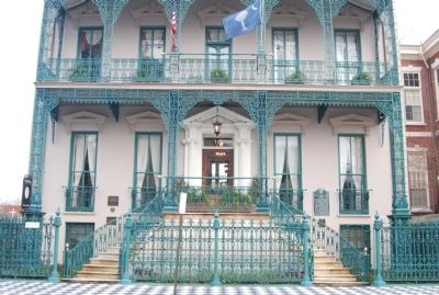
John Rutledge Home Marker
| 101 ► South Carolina, Charleston County, Charleston, Harleston Village — 10-12 — John Rutledge Home — |
| On Broad Street at Orange Street, on the left when traveling east on Broad Street. | |||
| 102 ► South Carolina, Charleston County, Charleston, Harleston Village — Site of the First Public Lending Library in the American Colonies — |
| On Saint Philip Street just north of Beaufain Street, on the right when traveling south. | |||
| 103 ► South Carolina, Charleston County, Charleston, Harleston Village — 10-22 — St. John's Church — |
| On Archdale Street south of Clifford Street, on the right when traveling north. | |||
| 104 ► South Carolina, Charleston County, Charleston, Harleston Village — William Harvey House — |
| On Broad Street, 0.1 miles west of King Street, on the left when traveling east. | |||
| 105 ► South Carolina, Charleston County, Charleston, South of Broad — 23 King Street — |
| On King Street just south of Ladson Street, on the right when traveling south. | |||
| 106 ► South Carolina, Charleston County, Charleston, South of Broad — Charleston Waterfront — |
| Near E Battery near Murray Blvd., on the left when traveling south. | |||
| 107 ► South Carolina, Charleston County, Charleston, South of Broad — Col. Othneil Beale's House — 99 - 101 East Bay — C. 1723 - 1740 — |
| On East Bay. | |||
| 108 ► South Carolina, Charleston County, Charleston, South of Broad — County of Charleston Historic Courthouse — |
| On Broad Street at Meeting Street, on the left when traveling east on Broad Street. | |||
| 109 ► South Carolina, Charleston County, Charleston, South of Broad — Dr. William Cleland's House — circa 1732 — |
| On Tradd Street, 0.1 miles east of Meeting Street, on the left when traveling east. | |||
| 110 ► South Carolina, Charleston County, Charleston, South of Broad — In Search of the Walled City — |
| On E Bay Street, on the right when traveling north. | |||
| 111 ► South Carolina, Charleston County, Charleston, South of Broad — Jacob Motte House — circa 1731 — |
| On Tradd Street at Meeting Street, on the right when traveling east on Tradd Street. | |||
| 112 ► South Carolina, Charleston County, Charleston, South of Broad — John Cordes Prioleau House — 68 Meeting Street — circa 1810 — |
| On Meeting Street at Ropemakers Lane, on the right when traveling north on Meeting Street. | |||
| 113 ► South Carolina, Charleston County, Charleston, South of Broad — Laurens - Rutledge House — 117 Broad Street — |
| On Broad Street at Orange Street, on the right when traveling east on Broad Street. | |||
| 114 ► South Carolina, Charleston County, Charleston, South of Broad — Major General Charles Cotesworth Pinckney — |
| 115 ► South Carolina, Charleston County, Charleston, South of Broad — Major Peter Bocquet's House — c.1770 — |
| On Broad Street, 0.1 miles east of King Street, on the right when traveling east. | |||
| 116 ► South Carolina, Charleston County, Charleston, South of Broad — Moultrie — |
| On East Battery Street, on the right when traveling south. | |||
| 117 ► South Carolina, Charleston County, Charleston, South of Broad — Poinsett Tavern — 28 Elliott — circa 1732 — |
| On Elliott Street, on the right when traveling west. | |||
| 118 ► South Carolina, Charleston County, Charleston, South of Broad — Poyas-Mordecai House — A Private Residence — c. 1788 — |
| On Meeting Street, 0.1 miles south of Broad Street, on the left when traveling north. | |||
| 119 ► South Carolina, Charleston County, Charleston, South of Broad — Robert Brewton House — Private Residence — |
| On Church Street, on the left when traveling north. | |||
| 120 ► South Carolina, Charleston County, Charleston, South of Broad — Section of parapet, or upper portion of the wall — |
| On E Bay Street, on the right when traveling north. | |||
| 121 ► South Carolina, Charleston County, Charleston, South of Broad — Sir Nathaniel Johnson — Governor of South Carolina — 1703 – 1709 — |
| On Concord Street near N Adgers Wharf, on the right when traveling north. | |||
| 122 ► South Carolina, Charleston County, Charleston, South of Broad — Stede Bonnet / Richard Worley — |
| On South Battery Street, on the right when traveling east on South Battery Street. | |||
| 123 ► South Carolina, Charleston County, Charleston, South of Broad — The Colonel Alexander Hext Tenements — 51-53 Tradd Street — circa 1736 — |
| On Tradd Street, 0.1 miles east of Meeting Street, on the right when traveling east. | |||
| 124 ► South Carolina, Charleston County, Charleston, South of Broad — The George Ducat House — 56 Tradd Street — circa 1740 — |
| On Tradd Street, 0.1 miles east of Meeting Street, on the left when traveling east. | |||
| 125 ► South Carolina, Charleston County, Charleston, South of Broad — The Site of Colleton Bastion — |
| On Meeting Street, on the right when traveling south. | |||
| 126 ► South Carolina, Charleston County, Charleston, South of Broad — The Site of Granville Bastion — |
| On East Bay Street, on the right when traveling south. | |||
| 127 ► South Carolina, Charleston County, Charleston, South of Broad — The South Carolina Society — |
| On Meeting Street south of Broad Street, on the right when traveling north. | |||
| 128 ► South Carolina, Charleston County, Charleston, South of Broad — The Walled City of Charles Town — |
| On U.S. 52, on the right when traveling north. | |||
| 129 ► South Carolina, Charleston County, Charleston, South of Broad — The William Vanderhorst House — 54 Tradd Street (Postmaster Bacot House) — circa 1740 — |
| On Tradd Street, 0.1 miles east of Meeting Street, on the left when traveling east. | |||
| 130 ► South Carolina, Charleston County, Charleston, South of Broad — Thomas Bee's House — 94 Church Street — circa 1730 — |
| On Church Street, on the right when traveling north. | |||
| 131 ► South Carolina, Charleston County, Charleston, South of Broad — 10-3 — Thomas Smith — Governor of Carolina — 1693 - 1694 — |
| On East Bay Street at Longitude Lane, on the left when traveling north on East Bay Street. | |||
| 132 ► South Carolina, Charleston County, Charleston, South of Broad — William Harvey House — 58 Meeting Street — circa 1770 — |
| On Meeting Street at Tradd Street, on the left when traveling south on Meeting Street. | |||
| 133 ► South Carolina, Charleston County, Charleston, West Ashley — “Brave & Happy Settlements” — Charles Towne, 1670-80 — |
| Near Old Town Plantation Road. | |||
| 134 ► South Carolina, Charleston County, Charleston, West Ashley — A Common Lodging — |
| Near Old Town Plantation Road. | |||
| 135 ► South Carolina, Charleston County, Charleston, West Ashley — A Temporary Home? — |
| Near Old Town Plantation Road. | |||
| 136 ► South Carolina, Charleston County, Charleston, West Ashley — Buildings “All of Wood”? — |
| Near Old Town Plantation Road. | |||
| 137 ► South Carolina, Charleston County, Charleston, West Ashley — Cassique of the Kiawah — 1670 — |
| Near Old Town Plantation Road. | |||
| 138 ► South Carolina, Charleston County, Charleston, West Ashley — 10-84 — Charles Towne / Old Town Plantation — |
| On Old Town Plantation Road, 1.5 miles east of Old Towne Road. | |||
| 139 ► South Carolina, Charleston County, Charleston, West Ashley — Crime & Punishment: “Tyed to the Usual Tree” — |
| Near Old Town Plantation Road near 1500 Old Towne Road. | |||
| 140 ► South Carolina, Charleston County, Charleston, West Ashley — Dr. Henry Woodward — Ca. 1646 - 1687 — |
| On Old Town Plantation Road, on the left when traveling east. | |||
| 141 ► South Carolina, Charleston County, Charleston, West Ashley — Ghost Structure — |
| Near Old Town Plantation Road. | |||
| 142 ► South Carolina, Charleston County, Charleston, West Ashley — Harnessing the Wind — |
| Near Old Town Plantation Road. | |||
| 143 ► South Carolina, Charleston County, Charleston, West Ashley — In Need of an Ally — |
| Near Old Town Plantation Road. | |||
| 144 ► South Carolina, Charleston County, Charleston, West Ashley — 10-33 — Maryville — |
| On Saint Andrews Boulevard at 5th Avenue, on the right when traveling north on Saint Andrews Boulevard. | |||
| 145 ► South Carolina, Charleston County, Charleston, West Ashley — Mixed Results — |
| Near Old Town Plantation Road. | |||
| 146 ► South Carolina, Charleston County, Charleston, West Ashley — On the Edge of an Empire — |
| Near Old Town Plantation Road. | |||
| 147 ► South Carolina, Charleston County, Charleston, West Ashley — Postponed Aspirations — |
| Near Old Town Plantation Road. | |||
| 148 ► South Carolina, Charleston County, Charleston, West Ashley — Protecting the Colony – The Palisade Wall — |
| Near Old Town Plantation Road. | |||
| 149 ► South Carolina, Charleston County, Charleston, West Ashley — Seeking Wealth, Sowing Servitude — |
| Near Old Town Plantation Road. | |||
| 150 ► South Carolina, Charleston County, Charleston, West Ashley — Seized! — |
| Near Old Town Plantation Road. | |||
| 151 ► South Carolina, Charleston County, Charleston, West Ashley — Ship Shaping — |
| Near Old Town Plantation Road. | |||
| 152 ► South Carolina, Charleston County, Charleston, West Ashley — Site of Old Charles Town — |
| On Old Town Plantation Road, on the left when traveling south. | |||
| 153 ► South Carolina, Charleston County, Charleston, West Ashley — St. Andrew’s Parish Church |
| On Ashley River Road (SC Highway 61) near Plainview Rd, on the right when traveling north. Reported missing. | |||
| 154 ► South Carolina, Charleston County, Charleston, West Ashley — Stained Dirt?! — |
| Near Old Town Plantation Road. | |||
| 155 ► South Carolina, Charleston County, Charleston, West Ashley — The Adventure, Trading Ketch — |
| Near Old Town Plantation Road. | |||
| 156 ► South Carolina, Charleston County, Charleston, West Ashley — The Search Goes On — |
| Near Old Town Plantation Road. | |||
| 157 ► South Carolina, Charleston County, Charleston, West Ashley — Trade, Profits and Support — |
| Near Old Town Plantation Road. | |||
| 158 ► South Carolina, Charleston County, Charleston, Wraggborough — Marion Square — Named in Honor of — General Francis Marion — |
| On King Street (Route 104). | |||
| 159 ► South Carolina, Charleston County, McClellanville — 10-40 — Hampton Plantation |
| On U.S. 17 at Rutledge Road (South Carolina Highway 10-857), on the right when traveling south on U.S. 17. Reported missing. | |||
| 160 ► South Carolina, Charleston County, McClellanville — 10-55 — Point Plantation — |
| On Pinckney Street when traveling south. | |||
| 161 ► South Carolina, Charleston County, Meggett, Yonges Island — 10-73 — Plainsfield Plantation — |
| On Towles Road (State Highway 10-92), on the right when traveling south. | |||
| 162 ► South Carolina, Charleston County, Mount Pleasant — 10-31 — Boone Hall Plantation — |
| On Long Point Road west of Garden Way, on the right when traveling west. | |||
| 163 ► South Carolina, Charleston County, Mount Pleasant — Charles Pinckney — 42 Years as a Public Servant — Charles Pinckney National Historical Site — |
| Near Long Point Road, 0.6 miles west of U.S. 17, on the left when traveling west. | |||
| 164 ► South Carolina, Charleston County, Mount Pleasant — Hobcaw Point Powder Magazine — |
| On Muirhead Road (State Highway 10-503) at Sugar Cane Way, on the right when traveling south on Muirhead Road. | |||
| 165 ► South Carolina, Charleston County, Mount Pleasant — Lowcountry Waterways — |
| Near Long Point Road, on the left when traveling west. | |||
| 166 ► South Carolina, Charleston County, Mount Pleasant — Point Plantation / Richmond Plantation — |
| On Henniretta Hartford Road at Gray Marsh Road on Henniretta Hartford Road. | |||
| 167 ► South Carolina, Charleston County, Mount Pleasant — The King's Highway / Coleman Boulevard — |
| On Coleman Avenue (U.S. 17) at Simmons Street, on the right when traveling east on Coleman Avenue. | |||
| 168 ► South Carolina, Charleston County, Mount Pleasant — Thomas Lynch at Rivertowne — |
| On Riverbluff Lane at Laurel Springs Lane on Riverbluff Lane. | |||
| 169 ► South Carolina, Charleston County, North Charleston — 10-75 — Inland Rice Fields — ca. 1701 - 1865 — |
| On Palmetto Commerce Parkway, 0.3 miles north of Trade Center Court, on the right when traveling north. | |||
| 170 ► South Carolina, Charleston County, North Charleston — 10-60 — The Elms — |
| Near University Blvd. (U.S. 78). | |||
| 171 ► South Carolina, Charleston County, North Charleston — 10-17 — The Elms Plantation — |
| On Elms Plantation Blvd.. | |||
| 172 ► South Carolina, Charleston County, Rantowles — 10-48 — The Stono Rebellion — 1739 — |
| On Savannah Highway (U.S. 17), on the right when traveling south. | |||
| 173 ► South Carolina, Charleston County, Sullivan's Island — Breach Inlet / Military History — |
| On Middle Street south of Jasper Boulevard (South Carolina Route 703), on the right when traveling north. | |||
| 174 ► South Carolina, Cherokee County, Blacksburg — 11-5 — Frederick Hambright — |
| On Battleground Drive (State Highway 216) at Rock House Road, on the left when traveling south on Battleground Drive. | |||
| 175 ► South Carolina, Cherokee County, Blacksburg — James Williams at Kings Mountain / The Battle of Kings Mountain — |
| On Battleground Road (Highway S46-705), on the left when traveling east. | |||
| 176 ► South Carolina, Cherokee County, Gaffney — From Cow Pasture to Battlefield — |
| On Battleground Tour Road. | |||
| 177 ► South Carolina, Cherokee County, Gaffney — Gaffney — Michael Gaffney — |
| On North Granard Street (U.S. 29) near West Buford Street, on the right. | |||
| 178 ► South Carolina, Cherokee County, Gaffney — 11-2 — Gaffney — |
| On North Granard Street (U.S. 29) near West Floyd Baker Boulevard (State Highway 11), on the right when traveling west. | |||
| 179 ► South Carolina, Cherokee County, Gaffney — Landscape Restoration Project — |
| Near Chesnee Highway (State Highway 11) near Battleground Road (State Highway 110). | |||
| 180 ► South Carolina, Cherokee County, Gaffney — 11-1 — Limestone Springs — |
| On East Oneal Street, on the right when traveling west. | |||
| 181 ► South Carolina, Cherokee County, Gaffney — Trail of Dog Wood Spring — 1780 — |
| On College Drive (State Highway 105) at Union Street (State Highway 105), on the left when traveling north on College Drive. | |||
| 182 ► South Carolina, Cherokee County, Gaffney — Welcome to Cowpens National Battlefield — A Revolutionary War Site — |
| On Piedmont Road south of Chesnee Highway (South Carolina Highway 11), on the right when traveling south. | |||
| 183 ► South Carolina, Cherokee County, Pacolet — Littlejohn Family Reunion — |
| On Asbury Road (State Highway 211). | |||
| 184 ► South Carolina, Chester County, Fort Lawn — Great Indian Warrior Trading Path — (The Great Philadelphia Wagon Road) — |
| Near Canal Road (State Highway 330) near Landsford Road (State Highway 843), on the right when traveling east. | |||
| 185 ► South Carolina, Chesterfield County, Cheraw — 13-1 — Old St. David's — |
| On Church Street at Front Street, on the right when traveling east on Church Street. | |||
| 186 ► South Carolina, Chesterfield County, Cheraw — The 71st Regiment of Foot — "The Fraser Highlanders" — |
| On Church Street at Front Street, on the left when traveling west on Church Street. | |||
| 187 ► South Carolina, Clarendon County, Greeleyville — 14-19 — Cantey Family Cemetery — |
| On Kenwood Road near Henry Road, on the left when traveling west. | |||
| 188 ► South Carolina, Clarendon County, Manning — Murray's Ferry - Santee River — |
| On North Brooks Street (U.S. 301) north of West Boyce Street (South Carolina Highway 261), on the left when traveling north. | |||
| 189 ► South Carolina, Clarendon County, Manning — Swamp Fox at Ox Swamp — |
| On South Boundary Street at West Boyce Street (South Carolina Highway 261), on the right when traveling north on South Boundary Street. | |||
| 190 ► South Carolina, Clarendon County, Rimini — 14-6 — Encounter at Halfway Swamp / Site of Original St. Mark's Church — |
| On Old River Road (State Highway 14-76) 1 mile south of Governor Richardson Road, on the right when traveling south. | |||
| 191 ► South Carolina, Clarendon County, Summerton — Elusive Francis Marion, 1780-1781 — |
| On South Church Street (U.S. 15) near Main Street (U.S. 301), on the right when traveling north. | |||
| 192 ► South Carolina, Colleton County, Ashepoo — 15-3 — Edmundsbury — |
| On Ace Basin Parkway (U.S. 17) at Clover Hill Road, on the right when traveling north on Ace Basin Parkway. | |||
| 193 ► South Carolina, Colleton County, Ehrhardt — John Jacob Heyer — Historical Marker — |
| On Confederate Hwy (SC 641), on the right when traveling west. | |||
| 194 ► South Carolina, Colleton County, Green Pond — 15-13 — Temple of Sport — |
| On Ace Basin Pkwy (U.S. 17) 0.1 miles south of Green Pond Highway (State Highway 303), on the left when traveling north. | |||
| 195 ► South Carolina, Colleton County, Jacksonboro — 15-8 — Bethel Presbyterian Church — |
| On Charleston Hwy (State Highway 64), on the right when traveling north. | |||
| 196 ► South Carolina, Colleton County, Jacksonboro — Pon Pon Chapel — Serving the Community for Many Years — |
| On Parkers Ferry Road. | |||
| 197 ► South Carolina, Colleton County, Jacksonboro — 15-14 — Pon Pon Chapel — |
| On Charleston Highway (County Route 64) south of Jacksonboro Rd (County Route 40), on the right when traveling north. | |||
| 198 ► South Carolina, Colleton County, Jacksonboro — Ruins of Pon Pon Chapel of Ease — St. Bartholomew’s Parish — |
| On Parkers Ferry Road, 0.1 miles north of Jacksonboro Road (County Route 40), on the right when traveling north. | |||
| 199 ► South Carolina, Colleton County, Jonesville — 15-15 — Salkehatchie Presbyterian Church — |
| On Hendersonville Hwy , US 17 A, on the left when traveling north. | |||
| 200 ► South Carolina, Colleton County, Round O — 15-6 — Martyr Of The Revolution / Hayne Hall |
| On Cemetery Road, 1.2 miles north of Charleston Highway (South Carolina Highway 64). Reported missing. | |||
403 entries matched your criteria. Entries 101 through 200 are listed above. ⊲ Previous 100 — Next 100 ⊳