On Arlington Road north of Edgemoor Lane, on the right when traveling north. Reported missing.
The first building for the Bethesda Fire Department, which is shown here, was located at 7620 Old Georgetown Road. It was built in 1926 and an addition was completed in 1931. The photograph was taken in the 1940's. — — Map (db m242274) HM
On River Road (Maryland Route 190) at Old Seven Locks Road, on the right when traveling west on River Road.
Originally a blacksmith shop, this home was built in the middle of the eighteenth century. It stands on a tract once known as “Magruder’s Honesty.” Believed to have been built by Ninian Magruder, Senior (d. 1751), it is one of the oldest standing . . . — — Map (db m916) HM
On Brookeville Road, 0.3 miles east of Grayhaven Manor Road, on the right when traveling east.
This log structure, acquired as part of Reddy Branch Stream Valley Park, was once part of Oakley Farm. Built before or just after emancipation, the cabin is representative of slave or tenant housing and is a rare surviving example. Reddy Branch, . . . — — Map (db m5415) HM
On Market Street, 0.1 miles east of North Street, on the left when traveling east.
Known as the Miller's House, this modest stone structure was likely built by the town's founder Richard Thomas, Jr. in the 1790s for the operator of his mill, which stood adjacent to this house, along Reedy Branch of the Hawlings River. The house . . . — — Map (db m76416) HM
William Lawson King and his family moved here in 1925. For over 60 years this property was part of their dairy operation, which was the largest in the county with 450 registered Holstein cows. At this farm, over 100 cows were milked twice daily, 365 . . . — — Map (db m140435) HM
On East Diamond Avenue just east of Park Avenue, on the left when traveling west.
This current building, developed by Inter-Continental Group (owned by the Blessing Family), stands on a site that has been a part of Gaithersburg's mercantile history since before 1894.
This 2-story building was built circa 1915 by JL Burns and . . . — — Map (db m101669) HM
Near Seneca Creek Road, 1.1 miles west of Clopper Road (Maryland Route 117), on the right when traveling south.
The Grusendorf Log House is one of a few remaining pre-Civil War structures in the Germantown/Gaithersburg area.
The Cabin was relocated to its present site next to the Seneca Creek State Park Visitor Center in the 1990s to preserve it from . . . — — Map (db m70455) HM
Near South Summit Avenue close to Old Towne Avenue, on the right when traveling south.
The house that would one day become City Hall was built for Henry Miller, an active businessman in early Gaithersburg, and his wife Rosa. In 1913, the house was bought by Edward P. Schwartz, a Washington, DC real estate broker. Here he established a . . . — — Map (db m3312) HM
Near South Summit Avenue near East Diamond Avenue, on the right when traveling north.
In 1893, Dr. Elisha C. Etchison purchased the northwest corner property at Diamond and Summit Avenues from John B. Diamond and opened a pharmacy / drug store. Although the business at this site has changed owners several times over the years, there . . . — — Map (db m3354) HM
Near South Frederick Avenue (Maryland Route 355) 0.1 miles north of Fairbanks Drive, on the left when traveling north.
This outbuilding located on the ridge of Summit Hall Farm is treasured as the oldest complete historic structure within the City of Gaithersburg. Historically known as the smokehouse, its notched logs and chinked mortar serve as a modern day . . . — — Map (db m57606) HM
Near South Summit Avenue just south of East Diamond Avenue, on the right when traveling north.
As the area's agricultural community flourished and the railroad was introduced, Gaithersburg soon became the commercial hub of the mid-county region. The Gaithersburg town center shifted from Frederick Avenue to Diamond Avenue near the train . . . — — Map (db m3349) HM
On South Summit Avenue just south of East Diamond Avenue, on the right when traveling north.
The building that now houses Gaithersburg's City government offices and Council chambers was originally a private residence built in 1895 by Rosa and Henry Miller. In 1913, this five-acre estate was purchased by Edward P. Schwartz, a successful . . . — — Map (db m128820) HM
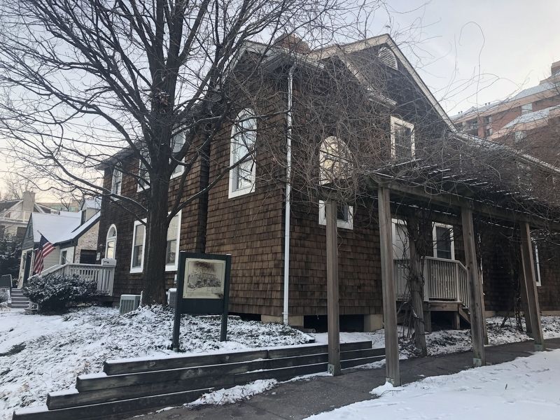
Near Wells Avenue, 0.1 miles east of South Summit Avenue, on the right when traveling east.
The Wells-Robertson House is sited on land that was once part of the 1723 land grant known as Deer
Park. William R. Hutton, a well-known engineer, and his heirs began dividing and selling the land
during the last half of the nineteenth century. In . . . — — Map (db m101668) HM
On Brink Road west of Laytonsville Road (Maryland Route 108), on the left when traveling west.
This property has been
placed on the
National Register
of Historic Places
by the United States
Department of the Interior
circa 1793 — — Map (db m133982) HM
On Brink Road at Rolling Ridge Lane, on the right when traveling west on Brink Road.
North of this monument, Robert Ober, a wealthy merchant built his home. A long tree-lined approach adds prominence to this 1½ story brick Georgian-style residence. This Tidewater style of architecture is rarely found in Montgomery County. . . . — — Map (db m72538) HM
Near MacArthur Boulevard at Goldsboro Road (Maryland Route 614). Reported permanently removed.
Yurts Around the World. These interesting and unusual buildings function as studios and classrooms in Glen Echo Park. Yurts have a long history. In Mongolia, yurts have been practical homes for thousands of years. In fact the word yurt . . . — — Map (db m247738) HM
On Connecticut Avenue (Maryland Route 185) north of Knowles Avenue, on the right.
1. c. 1901 Kensington B & O Railway Station. [Photo by Frank Chapman] The Kensington Train Station was built in 1891 and still services the Metropolitan branch of MARC Trains.
2. c. 1949 3758 & 3762 Howard Avenue These buildings were renovated . . . — — Map (db m116023) HM
Near Olney Sandy Spring Road (Maryland Route 108) east of Georgia Avenue (Maryland Route 97), on the right when traveling east.
Built by Whitson Canby c. 1800. Roger Brooke acquired the property for his daughter Sarah and her husband Dr. Charles Farquhar in 1822. They named the home after the town of Olney, England, the hometown of their favorite poet William Cowpers. When . . . — — Map (db m371) HM
On C&O Canal Tow Path west of MacArthur Blvd./Great Falls Road Climb.
Life was very different around the Great Falls Tavern during the canal era. The building before you began as a small lockhouse and was added onto twice until it became what you see today. The area around the tavern bustled with a community of over . . . — — Map (db m71604) HM
When Edgar was born on May 3, 1871, his father Thomas was a partner with Winfield Offutt in a mercantile operation at the intersection of River and Falls Road, then known as “Offutt's Crossroads.“ By the year 1880, when “Potomac . . . — — Map (db m106484) HM
Near Rock Creek Park Road, 0.4 miles north of Muncaster Road, on the right when traveling north.
The main house was built by Thaddeus Bussard in 1908 on the foundations of an original house that had been built by Nathan Magruder around 1778. The oldest part of the structure is the kitchen wing to the right, thought to date to the early 1800s. . . . — — Map (db m105115) HM
Near Rock Creek Park Road, 0.5 miles north of Muncaster Road, on the right when traveling north.
This farm was originally settled and developed by the Magruder family who lived here from 1734 to 1878. By 1778, Isaac Magruder built a one-story composite house of stone and log that was the original main block of the larger structure . . . — — Map (db m197869) HM
On North Adam Street near West Montgomery Avenue, on the right when traveling south. Reported permanently removed.
The Beall-Dawson property originally extended from Montgomery Avenue west to Forest Avenue and north to Martins Lane. The house was built in 1815 by Upton Beall, Clerk of the Montgomery County Court. It is a 2 ½ story brick Federal-style home . . . — — Map (db m137624) HM
The Beall-Dawson property originally extended from Montgomery Avenue west to Forest Avenue and north to Martins Lane. The house was built in 1815 by Upton Beall, clerk of the Montgomery County Court. The 2 1/2-story brick, Federal-style home is . . . — — Map (db m137626) HM
On South Washington Street at East Jefferson Street (Maryland Route 28) on South Washington Street. Reported permanently removed.
Long before the Emancipation Proclamation of 1863, some enslaved people freed themselves by escaping to Canada. In 1856, Alfred Homer walked and ran more than 500 miles from this site to freedom, despite the dangers of the Fugitive Slave Law. . . . — — Map (db m43557) HM
On Wood Lane west of North Washington Street, on the right when traveling west. Reported permanently removed.
For over fifty years, Celestine and Jesse Hebron operated one of the most successful printing businesses in the county in this handcrafted building.
Jesse Hebron started his printing business on Falls Road in 1932. After serving in World War II . . . — — Map (db m43568) HM
Racial tensions between African American and white church members peaked immediately before the Civil War. Pro-slavery parishioners joined the M. E. Church South in 1863. By 1868 the predominately African American M. E. Church North owned this . . . — — Map (db m32146) HM
On West Middle Lane at North Adams Street, on the right when traveling west on West Middle Lane. Reported permanently removed.
The area at North Adams Street and Middle Lane has four of the oldest surviving Rockville homes: 101, 106, and 5 North Adams, and the Beall-Dawson House.
The 1793 portion of the house at 5 North Adams is probably the oldest structure in . . . — — Map (db m137953) HM
In 1896, after the election of Mayor Joseph Reading on the Water Works ticket, the Mayor and Council of Rockville approved plans and specifications for a waterworks and electric light plant. The plant was intended to supplement and eventually . . . — — Map (db m109686) HM
Henry (Hal) Dawson, - son of Lawrence A. and Mary Kiger Dawson, left Rockville in 1885 for the Dakota territory, where he amassed a fortune as a cattleman. Hal returned to Rocky Glen with his wife Frances (Fannie) Williams Dawson and their four . . . — — Map (db m135560) HM
On Brooke Road, 0.1 miles west of Chandlee Mill Road, on the right when traveling west.
Mysteries of the Hopkins House
Set back from the main road at the end of a gravel driveway, stands the Hopkins House at 18465 Brooke Road. The oldest part of this house, of log construction, is a two-story, gable-roofed structure that runs . . . — — Map (db m188281) HM
On Park Police / Woodlawn Drive, on the right when traveling north.
Built by the Thomas Family in the early 1800s,this property, formerly known as Woodlawn, has national significance. In 1816, Samuel and Anna Thomas established a Friends Boarding School here. Francis Scott Key frequently visited his daughters who . . . — — Map (db m67596) HM
In 1842, Francis Preston Blair built a country house very near this park and divided his time between his 300 acre farm and his city residence "Blair House", which is now the President's official guest house in Washington, D.C. Blair was a powerful . . . — — Map (db m75736) HM
Take a moment to think about your home and family life. Thomas Harper and his wife Elizabeth raised six children in this home. Later, their son Richard and his wife Rachel raised fifteen children there. They kept chickens and pigs, had vegetable . . . — — Map (db m109224) HM
Bostwick House is an important, but fragile, historic resource with many community, local, and statewide partners engaged in collaborative planning to restore this significant structure. One of the first efforts at preservation was in 1936 when the . . . — — Map (db m95992) HM
Near Tulip Grove Drive just west of Tarragon Lane, on the right when traveling east.
Very little is known about the history of the Belair gardens. In the early 1750s Col. Benjamin Tasker, Jr. (1720-1760) "inclosed a large garden at a very large expense" probably in the formal French-style of planned beds. His nephew and heir Gov. . . . — — Map (db m207073) HM
On Melford Boulevard, 0.1 miles east of Tesla Drive, on the right when traveling west.
Built in 1840s, Melford is a two-and-one-half-story brick plantation house of side-hall and double parlor plan. It is distinguished by a two-story semi-circular bay and a parapetted double chimney at one gable end. It was built for Richard Duckett . . . — — Map (db m61614) HM
Near Belair Drive just south of Tulip Grove Drive, on the right when traveling south.
With the development of Belair At Bowie by Levitt and Sons, it is difficult, today, to imagine Belair Stable long ago — situated in the middle of rolling fields filled with horses, cattle and sheep.
[Captions:]
When first . . . — — Map (db m207077) HM
On White Marsh Park Drive, 0.3 miles west of Crain Highway (Maryland Route 3), on the right when traveling east.
This property has been
placed on the
National Register
of Historic Places
by the United States
Department of the Interior
Circa 1813 — — Map (db m137924) HM
On Thrift Road, 0.2 miles east of Tippet Road, on the left when traveling east.
One of the oldest surviving one-room schoolhouses in Prince George’s County, Thrift School was built in 1884. It replaced an earlier school from 1869 located on the same site. The School Commissioners, having acquired the one-acre tract from the . . . — — Map (db m6084) HM
Built in 1898, Morrill Hall is named for Senator Justin Morrill who introduced legislation (in 1861) leading to the creation of a system of land grant colleges, of which the University of Maryland is a member. The building survived a devastating . . . — — Map (db m21915) HM
Near Bladensburg Road (Alternate U.S. 1) north of Eastern Avenue, on the right when traveling north.
This old spring house was built by English colonists who in the late years of the 17th century had established a residence close by, climaxing an ocean voyage which ended on the banks of the nearby Eastern Branch.
Erected about 1683. The . . . — — Map (db m206598) HM
Built in 1928, Highland Park was the second high school for African Americans in Prince George's County, Maryland. It was one of 23 "Rosenwald Schools" constructed in Prince George’s County with financial assistance from the Julius Rosenwald Fund, . . . — — Map (db m40025) HM
On Saint Marys Place south of Main Street, on the left when traveling north.
Nicholas Snowden's mansion was built early in the 19th century on the present site of Pallotti High School. His daughter Louisa was the wife of Horace Capron who was important in developing the Laurel Cotton Mill. The mansion was home for succeeding . . . — — Map (db m128063) HM
The buildings on this property are clues to the
lives of the people who lived here over the past
two centuries. Sixteen buildings stand on the main part of the property. They all say something about who lived here, the crops they grew, and the . . . — — Map (db m194286) HM
“I should not be surprised if Government persists in their determination to quarrel with England that we should experience all the horrors of civil discord.”
Letter of Mary Welby De Butts to her brother, Richard Earl . . . — — Map (db m49145) HM
On Van Buren Street at Baltimore Avenue (U.S. 1), on the right when traveling east on Van Buren Street.
You are standing near the remains of a 19th century icehouse.
What is an icehouse? An icehouse is an underground facility designed to store ice during times of year when it is not easily available. Icehouses use the natural insulating qualities of . . . — — Map (db m117925) HM
On Van Buren Street at Baltimore Avenue (Route 1) on Van Buren Street.
Much of the area around you — some 1500 acres — was part of Riversdale, a plantation founded in 1801 by an aristocratic Belgian family — the Stiers — who had escaped the terror of the French Revolution and subsequent . . . — — Map (db m117967) HM
The Federal Tax list of 1798 includes this stable as an asset of Edward H. Calvert of Mt. Airy. It is 26 feet wide and 64 feet long. Built of brick in common bond with ventilating slits that have been filled in.
This photograph was taken prior . . . — — Map (db m133036) HM
On Old Marlboro Pike (Maryland Route 725) just west of Marlborough Drive, on the right when traveling west.
Traband House
This property
has been placed on the
National Register
of Historic Places
by the United States
Department of the Interior
— — Map (db m138533) HM
On North Commerce Street (Maryland Route 213) at Lawyers Row, on the left when traveling north on North Commerce Street.
In 1876 The Centreville National Bank of Maryland (predecessor to CNB) was established, and in 1904 constructed this building, its headquarters, to replace the one nearby that was destroyed by fire. — — Map (db m138260) HM
On South Commerce Street just north of Church Lane, on the right when traveling north.
This property is listed in the
National Register
of Historic Places
by the United States
Department of the Interior
Female Seminary
1876 — — Map (db m138259) HM
On Lawyers Row just west of Commerce Street (Maryland Route 213), on the right when traveling west.
The Queen Anne's County Courthouse was built between 1792 and 1794. Still in use today, it is the oldest continuously used courthouse in Maryland. In 1876, the entire building was enlarged to the rear and the wings raised to full stories, resulting . . . — — Map (db m138254) HM
On South Liberty Street (Maryland Route 213) just south of Church Lane, on the right when traveling north.
St. Paul's Parish was officially established as a result of the Vestry Act and the formal record of the vestry proceedings began on May 8, 1694. On May 1, 1834, the cornerstone for the church was laid by the Rev. Robert Goldsborough — its wall . . . — — Map (db m138264) HM
On South Commerce Street (Maryland Route 213) just north of Fayette Street, on the left when traveling north.
Built circa 1794 on the second lot to be sold in Centreville, the Tucker House is a good example of what many of the earliest homes in the town were like. It originally was two rooms deep and one room wide, a popular style of the Federal period in . . . — — Map (db m138258) HM
On Maryland Route 213 south of Water Street, on the right when traveling north.
Early plantation house with original paneling.
Listed as an “old dwelling” in a 1744 resurvey of “Smith’s Forrest,” patented 1681.
Moved 1964 by the Queen Anne’s County Historical Society to present site, part of . . . — — Map (db m3107) HM
On South Commerce Street (Maryland Route 213) just south of Ruthsburg Road, on the right when traveling north.
Wright's Chance was moved to this location in 1964 from its original site 6 miles east of town. Unlike the large brick plantation houses that have better survived, this type of frame structure was much more common during the Colonial period. The . . . — — Map (db m138257) HM
On Dominion Road (Maryland Route 552) 0.5 miles south of Goodhand Creek Road, on the left when traveling south.
The Kirwan House, built in 1879, was the home of former Maryland State Senator James E. Kirwan (1900-1908). The attached store, built in 1889, and his various business endeavors became the hub of the Chester/Dominion communities, and also served . . . — — Map (db m138384) HM
On Maryland Route 18 at Del Rhodes Avenue, on the left when traveling south on State Route 18.
The frame section of the structure dates to circa 1708 and is consistent with other Maryland courthouses in size, form, character and materials. The brick section was added circa 1820–40. Laws in the 18th century mostly were enforced by fines, . . . — — Map (db m3111) HM
On Cockey Lane north of Love Point Road, on the left when traveling north. Reported damaged.
This National Register site is located on a tract of land once called Steven's Adventure, granted to Francis Stevens in 1694. John Denny, a ship carpenter, mechanic and farmer, constructed the earliest northern part of the house soon after he . . . — — Map (db m137779) HM
On Old Love Point Road east of East Main Street, on the right when traveling east.
The precise construction date of this building is not yet known, but the structure appears on an 1877 map and served as the Stevensville Post Office for the first half of the 20th century. The government paid rent of $18.75 per month and $25 per . . . — — Map (db m137774) HM
On West Main Street (Maryland Route 300) just west of South Church Street (Maryland Route 313), on the left when traveling west.
After the Civil War the majority of the Trustees left Dudley's Chapel and came into Sudlersville to begin a new church, thus Wesley Chapel Methodist Episcopal Church was established in 1868. A new larger church built on the same site was later . . . — — Map (db m168196) HM
25 Asbury Avenue has been placed on the National Register of Historic Places by the United States Department of the Interior-9 July 1990 — — Map (db m66580) HM
On South Beckford Ave., 0.1 miles north of Washington Street, on the right when traveling north.
Parish established in 1692. St. Andrew's, a chapel-of-ease to All Saints' Church, Monie, was built in 1770 and consecrated in 1845. Tower erected 1859; spire and chapel 1893; wall and lich gate 1964. — — Map (db m3877) HM
On Coventry Parish Road at Old Rehobeth Road, on the right when traveling east on Coventry Parish Road.
Erected 1784 - 1792
Placed on the National Register of Historic Places 9 August 1984
Ruins stabilized 1985 - 1990 under the auspices of
Rehobeth Ruritan Club
Maryland Historical Trust
Somerset County Historical Trust
B. J. . . . — — Map (db m3881) HM
On Rennell Avenue, W west of S. Coral Place, on the right when traveling west.
The U.S. Navy developed Lexington Park to house the civilian workers who streamed into the area following the establishment of the Patuxent River Naval Air Station. Named for the storied carrier Lexington, it was the first planned community . . . — — Map (db m56719) HM
Near Three Notch Road (Maryland Route 235) just north of Buse Road, on the right when traveling north.
A Chesapeake Landmark Erected in 1896, the Cedar Point Lighthouse marked the southern point of where the Patuxent River and Chesapeake Bay come together. The lighthouse was a three-story brick and frame structure, with its cupola mounted 50 . . . — — Map (db m138622) HM
Protecting ships from treacherous waters has been a necessity since ancient times when bonfires and strategically placed cottage lanterns warned seamen of dangers in fog and darkness. Lighthouses of the Chesapeake and Potomac River waterways are . . . — — Map (db m9011) HM
Near Lighthouse Road (County Route 498) 1.4 miles east of Piney Point Road (County Route 249), on the left when traveling east. Reported permanently removed.
In 1861, the U.S. created the Potomac Flotilla (gunboats and other armed vessels) to patrol the river and intercept Confederate blockade runners. Nevertheless, St. Mary's County residents frequently ferried supplies and men across to Virginia. A . . . — — Map (db m188560) HM
On Christmas Eve 1835, the Federal Government purchased 2.5 acres of land from William and Charlotte Suter for $300. A year later the first lighthouse constructed entirely on the shoreline of the Potomac River went into service at Piney Point. . . . — — Map (db m192977) HM
Most freestanding light houses were accompanied by "keeper's quarters," which housed the light keepers and their families. The Piney Point Lighthouse and keeper's quarters were built in 1836 by John Donahoo of Havre de Grace.
The original . . . — — Map (db m8978) HM
On Lighthouse Road (Maryland Route 498) south of Hotel Cove Lane, on the left when traveling south.
Most freestanding lighthouses were accompanied by "keeper's quarters," which housed the light keepers and their families. The Piney Point Lighthouse and keeper's quarters were built in 1836 by John Donahoo of Havre de Grace, Maryland. . . . — — Map (db m207240) HM
On Point Lookout Road, at its southernmost tip (Maryland Route 5), on the right when traveling north.
For 136 years, the Point lookout Lighthouse
helped generations of Chesapeake Bay
mariners avoid shoals, navigate through dense
fog, and find the Potomac River’s mouth. The
beam shone until 1966, when an automated light off Point Lookout assumed . . . — — Map (db m104740) HM
On Point Lookout Road (U.S. 5) at Villa Road, on the right when traveling south on Point Lookout Road.
2000 acres granted Sept. 8th, 1639 to Thomas Cornwaleys who came to Maryland with “The Ark and The Dove.” He and Jerome Hawley were appointed “His Lordship’s Commissioners for the government of said Province” 1633 with . . . — — Map (db m977) HM
Near Old State House Road, 0.1 miles north of Point Lookout Road (Maryland Route 5), on the left when traveling west.
In his will, Garrett Van Sweringen left the Council Chamber and "and Coffee house" to his wife and children. It is one of the earliest references to a coffee house in English America. Although built as a brew and bake house, archaeological . . . — — Map (db m138845) HM
Near Margeret Brent Way, 0.1 miles west of Mathias De Sousa Drive, on the left when traveling west.
In the late 1650s, Simon Overzee built an unheated storage building in this location. Charles Calvert added a wattle and daub chimney around 1662, and housed or "quartered" guests and servants here. The quarter stood for another 30 years. This . . . — — Map (db m140613) HM
Near Trinity Church Road near Point Lookout Road (Maryland Route 5).
On this site was erected in 1676 the first State House of Maryland. Previous to this date the Assembly met in various places subsequent to the Planting of the Province at St. Mary’s City, March 27, 1634. The twelve stone markers forming a cross . . . — — Map (db m967) HM
Near Old State House Road west of Point Lookout Road (Maryland Route 5), on the left when traveling north.
Nothing survives above ground at this site. We have learned about what was here from archaeological excavations and historical documents, especially an inventory taken in 1700.
1644
William Smith built a two-room structure for . . . — — Map (db m138893) HM
On Aldermanbury Street Footpath just west of Middle Street Path, on the right when traveling west.
Buried here are ruins of the home of Maryland's first governor, Leonard Calvert. Built around 1636, this wooden structure was one of the largest buildings in St. Mary's City, measuring 40 feet wide by 68 feet long. Brick facing and chimneys were . . . — — Map (db m138838) HM
On U.S. 50, 0.2 miles south of Maryland Route 322, on the right when traveling north.
Built 1880, by people of Swedenberg, Lutheran, Methodist and Brethren Faiths near Peachblossom Creek and used by each denomination every fourth Sunday. The building originally known as Peachblossom Meetinghouse, was so named because the first peach . . . — — Map (db m3325) HM
On East Dover Street just east of South Harrison Street, on the right when traveling east.
Construction in 1801 as the personal residences and law office of Thomas J. Bullitt, this historic property was gifted to the citizens of the Mid-Shore on December 20, 2002, by
Mr. and Mrs. Nicholas F. Brady,
Mr. and Mrs. A. James Clark, and . . . — — Map (db m138293) HM
Keeper Ulman Owens met an untimely end at the Holland Island Bar Lighthouse in 1931. The official report ruled that he died by natural causes, but his bruised body and a nearby knife made some suspect foul play. We can't be sure this 1,000-pound . . . — — Map (db m138380) HM
On Mill Street east of Burns Street, on the right when traveling east.
The hexagonal screwpile cottage-style light station off Thomas Point was lit in 1875, replacing an earlier tower on the shore. In 1914, the US Lighthouse Service noted that Thomas Point Shoal's fog bell sounded a triple stroke every 30 seconds using . . . — — Map (db m138373) HM
On South Talbot Street (Maryland Route 33) just north of Mulberry Street, on the right when traveling north.
The original portion of this building was constructed as a residence in 1806 and was remodeled for Maryland National Bank St. Michaels Office in 1963. — — Map (db m138301) HM
Eagle, Dodson and Higgins Houses have looked out over the St. Michaels waterfront for well over a hundred years now. When they were first built, the town's harbor would have been full of work boats, everything from oyster tonging skiffs and canoes . . . — — Map (db m61335) HM
On Cherry Street just east of Burns Street, on the right when traveling east.
Higgins, Dodson, and Eagle houses have looked out over the St. Michaels waterfront for well over a century. When they were built, the harbor was full of workboats, from oyster tonging skiffs and canoes to large commercial sailing vessels. Between . . . — — Map (db m138307) HM
On Mill Street just east of Burns Street, on the right when traveling east.
When fog hides a lighthouse's beacon, sailors need an audible signal to guide them. So a fog tower containing a bell was frequently built alongside a lighthouse. Large bells, such as the 1,100 pound bell in this tower were used because their . . . — — Map (db m138371) HM
Kennedy Farm
Has Been Designated a
National
Historic Landmark
This site possesses National significance in commemorating the history of the United States of America
1974
National Park Service
United States Department of the . . . — — Map (db m151983) HM
On South Potomac Street (Maryland Route 65) near East Baltimore Street (U.S. 40), on the right when traveling south.
Boyhood home of Commodore Jesse D. Elliott, USN, (1872-1845) of Battle of Lake Erie fame during War of 1812. This National Register property preserved in memory of Mrs. Mary B.K. Bowman. — — Map (db m46719) HM
On South Potomac Street, on the right when traveling south.
The First Hagerstown Hose Company dates to 1815. Its hand pumper was originally housed in a shed located on the north side of St. John's Lutheran Church, one block to your left.
In 1881, the First Hose Company purchased this site and in July, . . . — — Map (db m129351) HM