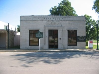
Thomas J. Florida established the Florida Brothers Company in 1926, supplying farm and home loans to families along the Cotton Highway. Mr. Florida built this Art Deco-influenced structure in 1935, featuring Indiana limestone. The building . . . — — Map (db m36612) HM
In a spot once home to the Mercantile Opera House, this Classical Revival-style building was built in 1936 as Mississippi County Bank, showcasing Italian marble and rich wood throughout. Continuing to finance farming interests, First National Bank, . . . — — Map (db m36610) HM
Established in 1904 the Fred G. Patterson Store was famous as a general mercantile, specializing in shoes and cotton pick sacks. A shoe at the entrance indicated the store was open for business. In 1993 the family donated the buildings for use as a . . . — — Map (db m36425) HM
The Neo-Classical style 1920 building, designed by noted architect Uzzell Branson, originally housed Citizens Bank, then, First State Bank, a mercantile store, and City Hall. A citizens group, including Congressman W.J. Driver, opened Planters Bank . . . — — Map (db m36702) HM
The Works Progress Administration built this building, dedicated on May 29, 1936, as a new post office. The structure served the citizens of Osceola and the Cotton Highway as a post office until the Postal Service relocated to Johnson Street. . . . — — Map (db m36616) HM
The first court house in Perry County, created in 1840, was erected in 1841 in what is known as the Old Town of Perryville. This house was burned in 1850. In 1871 a court house was built on the present location, in the New Town of Perryville. This . . . — — Map (db m156774) HM
After the Union army arrived in July 1862, Helena was no longer part of the Confederacy. It was in Union hands and the Union commander made law and policy. The Moore-Hornor Home across the street was one of many in Helena seized by the Union army. . . . — — Map (db m108030) HM
Traveling road shows, vaudeville, dog-and-pony shows, mind
readers, magicians, bell ringers and boxing matches-they all
appeared live at Helena's Grand Opera House. In the days before
radio, movies and television live entertainment was king. . . . — — Map (db m107996) HM
Richard L. Kitchens Post No. 41 of the American Legion
World War I veterans founded the American Legion, a charitable organization, in 1919. That year, Helena's veterans founded Richard L. Kitchens Post No. 41. The name honors a . . . — — Map (db m108000) HM
The first court house in Pike County, built of logs, was erected on the site of the town of Murfreesboro, which was laid out as a site for the county seat in 1833. — — Map (db m121284) HM
Kirkbride Potts, with help from his wife Pamelia Logan Potts, designed and constructed this large and stately building between 1850 and 1858. He patterned it after the Classical Revival style he knew in his home state of Pennsylvania; however, he . . . — — Map (db m120871) HM
In anticipation of statehood, construction on a capitol building began in 1833 and continued as Arkansas became the 25th state on June 15, 1836. The first legislative session convened at the new State House on Sept. 12, 1836. A second constitution . . . — — Map (db m313157) HM
Arkansas State Capitol Built in 1836 The Ordinance of Secession was adopted here, May 6, 1861. This tablet placed by Memorial Chapter No. 48, United Daughters of the Confederacy, June 15, 1936, the one-hundredth birthday of this . . . — — Map (db m157495) HM
On this site (120 to 122 West Markham) in January 1868, a new Little Rock City Halil opened
after construction started in 1867. It served as the seat of Little Rock government until April
1908, when the present city hall opened. After city offices . . . — — Map (db m208861) HM
This building was the site of the Arkansas Secession Convention of 1861 and seat of the Confederate Government until 1863. After the capture of Little Rock by Federal forces the Old State House became headquarters of a Unionist State Government led . . . — — Map (db m157500) HM
This property has been placed on the National Register of Historic Places by the United States Department of the Interior Arkansas Historic Preservation Program — — Map (db m229495) HM
Shortly after Arkansas was admitted to the Union in 1836, the Federal government established the Little Rock Arsenal for the storage of munitions and weapons in defense of the frontier. Eventually, more than thirty buildings were constructed on . . . — — Map (db m117241) HM
The steel beams surrounding you form a "ghost structure” to represent
the essence of the courthouse as it stood during Davidsonville's prime.
Arkansas's first courthouse took three years to complete (1819-1822).
It was the most prominent . . . — — Map (db m170920) HM
This property has been placed on the National Register of Historic Places by the United States Department of the Interior Arkansas Historic Preservation Program Department of Arkansas Heritage — — Map (db m220449) HM
Built in 1893, the office of Dr. Dewell Gann, Sr. is the only known bauxite building in existence. The building was constructed by patients who could not afford to pay for services he had rendered them. The soft stone was dug from a farm nearby, . . . — — Map (db m96597) HM
This building, on the N.W. bastion of the wall, was the commissary of the fort. Built in 1839, used until 1871 when the fort was abandoned as a military post. From 1861-65 it served as a hospital, guard house, and refuge, now a museum.
Erected . . . — — Map (db m57921) HM
This facade is all the remains of the five story building occupied from 1907 to 1955 by Reynolds - Davis Wholesale Grocery Company. The building subsequently served Checker Transfer & Storage Company from 1957 thru 1988 as well as other tenants . . . — — Map (db m57919) HM
In 1870, ground was broken for the three-story Fishback Block on the site of Jeremiah Kannady's blacksmith shop which manufactured Bowie knives for the Confederate Army. The builder, future Gov. William Meade Fishback (1831-1903), named the 7,000 . . . — — Map (db m57918) HM
William Blair was president of American National Bank in Fort
Smith and had interests in both a lumber yard and flour mill
during the 1890s. In September of 1898, he began secretly
constructing a new home as a Christmas present for his . . . — — Map (db m282489) HM
The first mention of this property is from 1838 when it was part of the brickyard that manufactured bricks to build the second Fort Smith. In 1877 the City Hotel was built here. In 1897, identical buildings were constructed to house the W.J. Murphy . . . — — Map (db m57917) HM
Home of W. W. Campbell and Victoria Mann
Campbell. W. W. Campbell was a bank, civic,
and agricultural leader in Eastern Arkansas.
influence extended nationally as reported in
the November, 1947, issue of Readers Digest
and the November, . . . — — Map (db m243314) HM
El Dorado
Masonic Temple
has been placed on the
National Register
of Historic Places
by the United States
Department of the Interior
Erected 1924 — — Map (db m121976) HM
This marks the site of the second court house built in Union County. Completed May 1st, 1848. The spot was originally a pond where ducks gathered in season. Emigrants in search of home sites frequently camped alongs its banks. It was filled in under . . . — — Map (db m121292) HM
Hill Hall was named for General Daniel Harvey
Hill, who served under General Robert E.
Lee during the Civil War and was the fourth
president of the university. The hall was
built in 1901 and opened for use as a men's
residence hall in early . . . — — Map (db m224342) HM
This Ante-Bellum Home was built on land granted to Washington County by an Act of Congress to build a court house, entitled “An Act for the Relief of Fayetteville, in the Territory of Arkansas,” and signed June 26, 1834 by . . . — — Map (db m59911) HM
This house was built in 1845 by Judge David Walker. He sold it in 1850 to Stephen K. Stone, whose family lived here during and after the Civil War. A solid shot from Fagan’s Confederate Battery on October 3, 1864 pierced the west wall of the . . . — — Map (db m59910) HM
The circular stone wall that encloses the Battle Monument is built of stones from historic structures of Washington County. Some 40 communities are represented, including the pioneer settlements at Cane Hill, Cincinnati, Viney Grove, Rhea's Mill, . . . — — Map (db m35360) HM
Built 1858 - Renovated 1867
Upstairs Added 1872
Benjamin Black was Mayor of Searcy
1886 - 1894. They had eleven children who lived here until the last died in 1979.
The house was purchased and restored by Dr. & Mrs. Porter Rodgers . . . — — Map (db m234423) HM
City of Berkeley Landmark
Designated in 2001
North Branch Berkeley Public Library
James W. Plachek, Architect, 1936
North Branch Library is one of Berkeley’s many civic buildings by James Plachek, including the Central Library (1930), . . . — — Map (db m15868) HM
City of Berkeley Landmarks
designated in 1992
In one of Berkeley’s more eccentric experiments in living, Charles and Florence Boynton built their family residence as a version of a Greco-Roman temple with no walls. Two circular, open-air porches . . . — — Map (db m53864) HM
City of Berkeley Landmark
designated in 1983
This Zig-Zag Moderne building, designed for the sale and servicing of Buick automobiles, captures the glamour, rising affluence, and sophistication of the post-World War I era. Charles Howard, who . . . — — Map (db m54334) HM
Samuel H. Kress began his chain of retail stores around 1900 and soon these “five and dime” variety stores dotted downtowns across America. Kress’s own company architects designed stores of high quality and adapted them to fit into the . . . — — Map (db m52380) HM
Shattuck Square is a group of three buildings constructed on the site of a former railroad freight yard, as a northern anchor to Berkeley’s historic downtown commercial district. It is the city’s only work by the San Francisco architectural firm . . . — — Map (db m52391) HM
City of Berkeley Landmark
designated in 1984
John Tupper and Lawrence Reed constructed this building for their music store, which they had established in Berkeley in 1906. University of California art professor Eugen Neuhaus complimented them . . . — — Map (db m54507) HM
City of Berkeley Landmark
designated in 1980
Berkeley’s elegant Main Post Office is representative of the Second Renaissance Revival style, also called Neo-Classical Revival. Government buildings constructed in this era were designed to . . . — — Map (db m54260) HM
City of Berkeley Landmark
designated in 2005
This corner store was built for Stella King’s dry goods business and upstairs residence. Until the shop closed in 1923, it was a gathering place where neighbors could find everything from sewing . . . — — Map (db m54722) HM
Robert Agers constructed this building to manufacture "the very best soda water" for customers throughout California. The recessed storefronts, second-floor oriel windows, and high false front are all largely unchanged from a 1904 expansion. The . . . — — Map (db m29383) HM
City of Berkeley Structure of Merit
designated in 1988
German immigrant George Hunrick built one of Berkeley’s many neighborhood groceries on this site when the north Berkeley hills were in an early stage of development. In those days before home . . . — — Map (db m54189) HM
No pivotal battles that changed the course
of history were fought here. Nary a famous
person was ever born or raised, lived, slept,
dined, or even gave a glancing look at this
place. This location did not provide a monumental role in the . . . — — Map (db m147452) HM
City of Berkeley Landmark
designated in 1979
Toward the end of the 19th-century, a large Finnish immigrant community was located in west Berkeley. Together they constructed this wooden building which integrates traditional Finnish and American . . . — — Map (db m53834) HM
City of Berkeley Landmark
designated in 2001
During the early 20th century, the Santa Fe Railroad provided three-day passenger and freight service between Chicago and the Bay Area. This depot was one of three major rail stations in Berkeley. . . . — — Map (db m53828) HM
William C. Hays, Architect, 1922
James W. Plachek, Architect, 1930
John Reid, Jr., Architect, 1935
ELS/Elbasani & Logan Architects, 1998
As electric streetcar transportation improved and expanded in the early 20th-century, this section . . . — — Map (db m53873) HM
Hiram Lovell, Architect, 1910, 1914
James W. Plachek, Architect, 1921
The popularity of early movies created a demand for new spaces to accommodate eager audiences. South Berkeley’s first neighborhood theater with 144 stools for seats was . . . — — Map (db m53816) HM
City of Berkeley Landmark
designated in 1982
In the early 20th century, this was one of two banks anchoring the busy Lorin business district’s streetcar intersection. The building remained a bank until the 1980s. Its architecture combines a . . . — — Map (db m53815) HM
Berkeley History
Horse-drawn wagons once carried goods to the Berkeley Free Market housed here. In 1952 the structure was modernized to accommodate automobile showrooms, with artist studios above. Richard Diebenkorn, Elmer Biscoff, William . . . — — Map (db m54333) HM
This house dedicated to the promotion of understanding and fellowship among the peoples of all nations and similar international houses in New York City at the University of Chicago and at the Cite Universitaire Paris were given by John D . . . — — Map (db m283660) HM
The McCreary-Greer House and neighboring turn-of-the-century houses on this block are survivors of one of the first residential districts developed around the University campus. This house, with its original garden area and carriage house, . . . — — Map (db m52300) HM
Berkeley History
Reflecting West Berkeley’s early industrial heritage, this plant remains one of the city’s largest brick buildings. Once used to produce chemicals for a cluster of nearby industries that manufactured soaps, cleaning agents, paper . . . — — Map (db m53812) HM
These landmarks form the historic core of the first University of California campus, opened in 1873: Founders’ Rock, University House, Faculty Club and Glade, Hearst Greek Theatre, Hearst Memorial Mining Building, Doe Library, Sather Tower and . . . — — Map (db m290973) HM
This seven acre park is on the site of Dublin's original settlement that was established in 1850. Within the park are the 1856 Murray Schoolhouse, the 1859 St. Raymond Church, the 1880 Kolb Old House, the 1911 Kolb Craftsman Bungalow, the 1870 . . . — — Map (db m59946) HM
The Oldest Extant Catholic Church Building in Alameda and Contra Costa Counties
This land was donated as a Catholic site by Michael
Murray and Jeremiah Fallon, who was one of the
rescuers of the ill fated Donner Party in the Sierra.
Tom . . . — — Map (db m26701) HM
Built at the crossroads in 1862 by James Witt Dougherty where it served travelers going by stagecoach from Oakland to Stockton and from San Jose to Martinez and Sacramento. This area was named Dougherty Station from 1862 until 1878, and the hotel . . . — — Map (db m69726) HM
Built in 1860 by John Green this building has been in constant use as a business building. It began as a general store, changed into a neighborhood pub, and now is a restaurant.
From 1914 – 1948 the northeast corner of the building was . . . — — Map (db m28578) HM
Joseph Silviera Leal and Julia Perry Leal built this tank house on their ranch in the Mission San Jose area of Fremont in 1925. The lower floor was a storage room and the upper floor a bedroom. The tank on top stored 5,000 gallons of water pumped . . . — — Map (db m29090) HM
With the discovery of gold in California, the town around the Mission San Jose became the gateway and provision center for the “49er” on his way to the Southern Mines.
To meet these demands, the firm of Strauss and Co. was founded by . . . — — Map (db m64904) HM
At the Ohlone Indian village of Oroysom, Padre Fermín Francisco de Lasuén founded this fourteenth of twenty-one Franciscan missions June 11, 1797. Taught by Padre Narciso Durán, the Ohlone Orchestra and Choir became famous. By 1830 almost 2,000 . . . — — Map (db m100551) HM
Thomas Jefferson Chadbourne and his wife Nettie built this Victorian carriage house in the 1870’s. He owned fine racing horses and stock horses and wanted them housed in suitable surroundings.
They purchased the property in 1872 from Charles C. . . . — — Map (db m28826) HM
Built in 1886 for Neal and Sarah McConaghy, this 12 room Victorian farmhouse represents the beauty and elegance of a bygone era. Members of the family resided here until 1972. In response to community interest, Hayward Area Recreation District . . . — — Map (db m94565) HM
Built in 1869 by William Meek, a pioneer of commercial agriculture, the mansion is characteristic of the affluent agricultural society of the Victorian era in California.
The estate is on the site of the former Rancho San Lorenzo. This area . . . — — Map (db m149204) HM
This building replaces the two-story Palmtag Building, originally constructed by Leopold Palmtag in 1892. He settled in Hayward in 1860 and served as a town trustee. The building housed various businesses, including a radio station and a drug store. . . . — — Map (db m28907) HM
This granite faced building was designed in the Classic Renaissance Revival Style for the Bank of Italy in 1921. It later became the thirteenth branch of the Bank of America. From 1957-1978, this building served as Livermore's city hall.
Listed on . . . — — Map (db m17878) HM
Livermore Public City Library
1911 to 1966
City of Livermore Historic Preservation Landmark Site
Dedicated July 1996
Operated by Livermore Area Recreation and Park DistrictNearby Rededication Plaque reads:
Andrew J. . . . — — Map (db m17754) HM
Built by by butcher Wm. E. Hinz and wife Rose for $1050. Purchased 1923 by Nienburgs and 1937 by Camillo Croce, vintner and brandy purveyor of Croce Winery, later the Livermore Winery. Remained in the Croce family until 2007. — — Map (db m199557) HM
Constructed with bricks salvaged from the Livermore Brewery, built 1874, destroyed by fire 1908
City of Livermore Historic Preservation Landmark Site Dedicated July 1996 — — Map (db m17870) HM
Fennon was a butcher. Levy was a tailor, saloon keeper and auctioneer. Both were prominent local business men.
Commemorated by the City of Livermore
Historic Preservation Commission
May 2008 — — Map (db m195149) HM
John H. Wilson was co-owner of the California Transfer Company, an important building materials distributor.
Commemorated by City of Livermore
Historic Preservation Commission
May 2007 — — Map (db m195143) HM