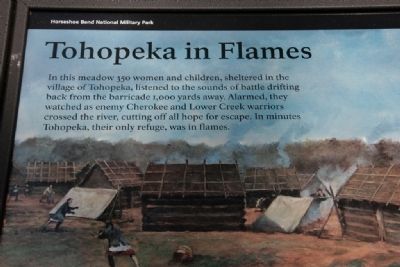
In this meadow 350 women and children, sheltered in the village of Tohopeka, listened to the sounds of battle drifting back from the barricade 1,000 yards away. Alarmed, they watched as enemy Cherokee and Lower Creek warriors crossed the river, . . . — — Map (db m47469) HM
I never had such emotions as while the long roll was beating...It was not fear, it was not anxiety or concern of the fate of those who were so soon to fall but it was a kind of enthusiasm that thrilled through every nerve and animated me with . . . — — Map (db m46675) HM
Near Horseshoe Bend Road (Alabama Route 49) 2.1 miles north of Freeman Road, on the left when traveling north.
Originally the name "Creek" referred only to
Muskogee Indians living near Ochese Creek in
central Georgia. Over time the name spread to
include all Muskogee people along the rivers of
present-day Georgia and Alabama. At one time
the region held . . . — — Map (db m223985) HM
On the morning of the battle, Maj. Gen. Andrew Jackson’s Indian allies surrounded the lower portion of Horseshoe Bend.
The Cherokee were positioned across the river from where you stand; the Lower Creek were farther upriver to your left.
. . . — — Map (db m47446) HM
On State Highway 22 East at Church Street, on the right when traveling north on State Highway 22 East.
Jackson fortified position here during Creek Indian War (1813-1814). Although repeated attacks by the Red Sticks were repulsed, Jackson withdrew with the Indians pursuing. — — Map (db m45736) HM
On 28th Avenue south of 2nd Street, on the right when traveling south.
The Trail of Tears led thousands of Creek Indians through Tuscaloosa, capital of Alabama in 1836. Chief Eufaula addressed the legislature with these words:
"I come here, brothers, to see the great house of Alabama and the men . . . — — Map (db m119308) HM
On County Road 63 at County Road 61, on the left when traveling south on County Road 63.
This is the M1841 Mountain Howitzer. It was used by the United States Army during the mid-nineteenth century from 1837 to about 1870. The cannon saw service during the Mexican-American War, the American Indian Wars, and during the American Civil . . . — — Map (db m182874) HM
Near Dragoon Springs on October 12, 1872, General O.O. Howard and Cochise, Chief of the Chiricahua Apache Indians, ratified a peace treaty ending years of warfare between that tribe and the white settlers. Cochise's stronghold was hidden deep in the . . . — — Map (db m27877) HM
On Apache Pass Road 13 miles south of Business Interstate 10, on the left when traveling west.
There are two markers on a single kiosk
Apache Pass is a low divide separating the massive Chiricahua Mountains from the Dos Cabezas Mountains. This landscape formed a rugged corridor through which people and goods were moved. The Pass . . . — — Map (db m100810) HM
After the events on the afternoon of February 4th, Bascom ordered the command to move toward, and fortify, the stage station. According to Sergeant Daniel Robinson:
“Our wagons were placed end to end, forming a semicircle, covering one . . . — — Map (db m100815) HM
Near Fort Bowie Trail 1.5 miles south of Apache Pass Road.
This massive adobe structure was among the earliest built at the new fort. By the mid-1880s, it had a shingled and pitched roof, attractive porches, kerosene lamps, and landscaping. The kitchen was behind the barracks; the mess hall adjacent.
. . . — — Map (db m100998) HM
Palatable food during the fort's early days was a constant problem; the soil was poor quality, lacking nutrients, and other sources of fresh food were distant. Though neighboring ranches supplied some vegetables and meats, they were still a day's . . . — — Map (db m313667) HM
On West Fifth Street, on the left when traveling west.
[Side 1: In English :]
September 4-8, 1986, Arizonans marked the return of the Chiricahua Ex-Prisoners of War and their descendants in ceremonies that completed a spiritual circle. We remembered and reflected on the clash between . . . — — Map (db m42513) HM
Near Fort Bowie Trail 1.5 miles south of Apache Pass Road.
The fort's most elaborate structure, a two story, Victorian-style mansion, was built in 1884-1885 for about $4,000.00. An expensive home at that time! Among its thirteen rooms (originally designed as a duplex) were a drawing room, a sewing room with . . . — — Map (db m101000) HM
To your right, a spur trail follows a military road 300 yards to the first Fort Bowie ruins.
On July 28, 1862, a 100-man detachment of the 5th California Volunteer Infantry began construction of the primitive fort, completing it two weeks . . . — — Map (db m218624) HM
On South Apache Pass Road at Interstate 10 on South Apache Pass Road.
A Regional Legacy
Cochise. Geronimo. Though their reputations were fierce, the Chiricahua Apaches didn't stop explorers, prospectors, settlers, and merchants from Westward immigration. To establish a lifeline between the East and California, . . . — — Map (db m37761) HM
Near Fort Bowie Trail 1.5 miles south of Apache Pass Road.
Enlisted infantrymen found that privacy was not a feature of barracks life. Privates and corporals bunked together in the main room; sergeants occupied small adjoining rooms.
Each soldier stored his military gear and personal belongings on a . . . — — Map (db m101002) HM
On I-10 Extension (Interstate 10), on the left when traveling east.
Established 1862 following the Battle of Apache Pass, largest conflict in Arizona Indian Wars. Massed Apaches under Cochise and Mangas Coloradas were routed by howitzers fired by California Volunteers attacked in the pass. Fort Bowie overlooked . . . — — Map (db m6994) HM
Near Apache Pass Road 2.3 miles south of Bear Springs Road.
The Post Cemetery predated the establishment of Fort Bowie, when soldiers of the California Column were interred here in 1862. The area was unfenced until 1878, when a four-foot adobe wall was erected to protect the graves from desecration by post . . . — — Map (db m68858) HM
Near Fort Bowie Trail 1.5 miles south of Apache Pass Road.
The equivalent of the modern army post exchange, the post trader offered for sale items not supplied by the army – toilet articles, sewing supplies, tobacco, medicinal cure-alls, fresh vegetables, canned fruits, and a wide variety of . . . — — Map (db m101003) HM
Near Fort Bowie Trail 1.5 miles south of Apache Pass Road.
Two years after the 1872 peace agreement with Cochise, the great Apache chief died. Several hundred Chiricahuas were relocated on the San Carlos Indian Reservation. However, Geronimo and over a hundred of his followers escaped the roundup, to begin . . . — — Map (db m100953) HM
On February 4, 1861, 2nd Lt. George Bascom, and his detachment of 54 men encamped two hundred yards east of here. Bascom’s mission was to find Cochise, recover a kidnapped boy and return livestock assumed taken by the Chiricahua Apaches. . . . — — Map (db m42008) HM
An advance guard of 96 California Volunteers, marching toward the San Simon River to establish a supply depot for the California Column, followed the Butterfield Road through Apache Pass. As they approached the abandoned stage station, Cochise and . . . — — Map (db m100820) HM
On May 5, 1862, a Confederate foraging party rounding up cattle near the abandoned Butterfield Overland Mail Station battled a group of Apaches. The soldiers were members of Company A, Governor John R. Baylor's Regiment of Arizona Rangers, under . . . — — Map (db m83149) HM
The San Antonio and San Diego Mail Line began service across Arizona to the Pacific coast in July, 1857. Its route included a stop here near the Dragoon spring. The San Antonio Line was commonly known as the "Jackass Mail" because mules were used . . . — — Map (db m76940) HM
On North Tex Canyon Road near East Rucker Canyon Road.
Camp Supply served as the base for two companies of Indian Scouts: Company C commanded by 2nd Lieutenant John A. Rucker, and Company D led by 1st Lieutenant Austin Henely. Each Company included between 32 and 40 Scouts who enlisted for 6 months at a . . . — — Map (db m42080) HM
Near North Tex Canyon Road 0.8 miles east of East Rucker Canyon Road.
The Bakery was first described in Camp records in May, 1879. It was a log building with an earth roof and an adjacent guardhouse. The nearby storehouse (commissary) was a stockaded tent structure with vertical log walls and a canvas tent roof. In . . . — — Map (db m151079) HM
Near North Tex Canyon Road near East Rucker Canyon Road.
June, 1876 - The Chiricahua Apache Indian Reservation is abolished. Apaches who are not relocated to other reservations are labeled renegades. Military patrols are sent throughout southeastern Arizona in search of them.
March, 1878 - . . . — — Map (db m42087) HM
Near North Tex Canyon Road 0.8 miles east of East Rucker Canyon Road.
Camp Supply became known as Camp Rucker as a result of a tragic incident that took place soon after the camp was established.
On July 11, 1878, a flash flood occurred in White River Canyon (now Rucker Canyon). Lieutenants John A. . . . — — Map (db m151081) HM
On West Gleeson Road 2.5 miles west of Arizona Highway 191, on the right when traveling west.
During the Chiricahua Apache Campaign (1861-1886) cavalry troops on maneuvers camped here at a permanent source of water known as Soldiers Hole.
W. C. Sanderson and Ambrose Lyall struck artesian water nearby in 1883.
In 1892 a . . . — — Map (db m28363) HM
On Arizona Route 82 at N Old Fairbank Rd, on the left when traveling west on Arizona Route 82.
The San Pedro Riparian National Conservation Area has a storied past well beyond its designation as a sanctuary for its riparian ecosystem. The following narrative provides a brief history regarding the use of this area as a military installation . . . — — Map (db m250008) HM
On Arizona Route 80 at milepost 406 near Skeleton Canyon Road, on the right when traveling east.
Near here Geronimo, last Apache Chieftain, and Nachite with their followers surrendered on Sept. 6th 1886 to General Nelson A. Miles. U. S. Army. Lieutenant Chas. B. Gatewood with Kieta and Martine Apache scouts, risked their lives to enter the camp . . . — — Map (db m28355) HM
On Bonita Canyon Road, on the right when traveling east.
They came when only the brave dared come: They stayed where only the valiant could stay. Born in Sweden. Americans by choice - not by accident of birth, they loved their adopted country and served her well.
Neil
Served five years in the . . . — — Map (db m28368) HM
On East Stewart Street south of North Haskell Avenue ( Route 186), on the right when traveling east.
Built by Delso Smith as an Army Officer reception center during the Indian wars. Bought by Mr. Schwertner in 1893 and donated to the local Historic Society in 1980.
It is listed on the National Register of Historic Places. — — Map (db m28418) HM
On Rim Road (Forest Road 300) 12 miles east of Route 87, on the left when traveling east.
Seven miles north of this point a band of Apache Indians were defeated by United States troops on July 17, 1882. A group of tribesmen from the San Carlos Apache reservation had attacked some ranches in the vicinity, killing several settlers. Cavalry . . . — — Map (db m67424) HM
On Rim Road (Forest Road 300) 1.2 miles east of Route 87, on the left when traveling east.
Under the direction of General George Crook this trail was built in the early 1870's. Starting at Fort Whipple, it winds down to Fort Verde then eastward across the Mogollon Rim to Fort Apache covering 200 miles. It was used as a supply route by . . . — — Map (db m67419) HM
On Rim Road (Forest Road 300) 8.4 miles east of Route 87, on the left when traveling east.
Under the direction of General George Crook this trail was built in the early 1870's. Starting at Fort Whipple, it winds down to Fort Verde then eastward across the Mogollon Rim to Fort Apache covering 200 miles. It was used as a supply route by . . . — — Map (db m67420) HM
On The Apache Trail (Arizona Route 188 at milepost 245), on the right when traveling north.
Veteran of the Civil War and for twenty years a leader of Scouts for the U.S. Army in Arizona Indian troubles. Was killed on this spot February 19th, 1907 by a rolling rock during construction of the Tonto Road. His body is buried in the cemetery at . . . — — Map (db m34114) HM
On U.S. 70 at milepost 302, on the left when traveling east.
Named for the rebellious medicine man who led the Chiricahua Apaches on their last raids, to surrender, and then into exile in Florida and Oklahoma. Their descendants lived in Eastern Arizona again. This was also the site of original Camp Thomas, . . . — — Map (db m28050) HM
On U.S. 70 at milepost 306, on the left when traveling east.
Melvin Jones was born on January 13, 1879, near this site in Fort Thomas. He lived here for the first eight years of his life, during the Indian Wars here. In 1917, Melvin Jones formed Lions Clubs International with 20 delegates representing 27 . . . — — Map (db m28051) HM
On U.S. 70 at milepost 364.7, on the left when traveling east.
In Memory Of
Horatio Harris Merrill
Born January 3, 1837
And his daughter
Eliza Ann Merrill
Born July 27, 1881
Who, while traveling by team and wagon from Pima, Arizona to Clifton, Arizona, were . . . — — Map (db m36243) HM
On Arizona Route 75 at milepost 392, on the left when traveling north.
This area served as a resting place for Apache war parties during the raids of the 1880's. Near here Felix B. Knox, a cattleman and gambler, stayed behind to face Indians while his wife, children, and hired man escaped in a buckboard. Out of respect . . . — — Map (db m36371) HM
On Poston Road/Mohave Drive (Arizona Route 1 at milepost 3), 6 miles north of Interstate 10, on the left when traveling north.
We honor our ancestors who died violent deaths at the hands of their captors and at this concentration camp. We greet the spirits of our ancestors and embrace their strength and above all else, their will to survive this holocaust: the Hualapai . . . — — Map (db m36012) HM
On Arizona Route 88 at milepost 241, on the left when traveling east.
Alchesay led his people in war and peace
Alchesay Canyon, to your right, was named for a great leader. Chief Alchesay, born around 1853, was a leader among the White Mountain Apache. Other Apaches looked up to him not only because he . . . — — Map (db m34073) HM
On Beeline Highway (Arizona Route 87 at milepost 190) near North Fort McDowell Road, on the right when traveling north.
From 1866 to 1868 this outpost of Ft. McDowell served as a departure point for military expeditions against the Tonto and Pinal Apache Indians. — — Map (db m27679) HM
On Beeline Highway (Arizona Route 87) near North Fort McDowell Road, on the right when traveling north.
This important military post protected central Arizona settlements from the Tonto Apaches during the Indian wars 1865-1886. Its function as a military post ended in 1890 and it became a reservation by executive order, September 15, 1909 as home of . . . — — Map (db m27681) HM
The Medal of Honor is the highest military decoration awarded by the United States Armed Forces to those who distinguish themselves "…conspicuously by gallantry and intrepidity at the risk of their lives above and beyond the call of duty while . . . — — Map (db m29435) HM
On Fort Beale Road at Wagon Trail Road, on the left when traveling north on Fort Beale Road.
This camp, established March 25, 1871 by Company F, 12th Infantry commanded by Capt. Thomas Bryne, was located at a spring used by Indians for centuries. It was named for Navy Lt. Edward F Beale who established a wagon road along the 35th parallel. . . . — — Map (db m29411) HM
On Fort Beale Road at Wagon Trail Road, on the left when traveling north on Fort Beale Road.
In Memory of
Our Hualapai Ancestors
Who Fought Against Cultural Genocide
With Bravery and Foresight
They Sacrificed Their Lives
So The Hualapai People's
Survival May Continue
Today And Forever…
This location was a . . . — — Map (db m36013) HM
On Main Street (Route 66) 0.1 miles east of Beacon Hill Road.
Olive Ann Fairchild, Indian captive and lecturer, daughter of Royse (Royce) and Mary Ann (Sperry) Oatman, was born in Illinois in September 1837 or 1839. In 1850 the family joined a wagon train bound for the part of the Colorado River now in . . . — — Map (db m188959) HM
On General Crook Street, on the right when traveling east.
Built of adobe bricks in 1876, this is the third oldest surviving building at Fort Apache. Originally the Adjutant's Office (administrative office) of the post, it also served variously as post headquarters, military Post Office, telegraph office, . . . — — Map (db m36799) HM
On General Crook Street, on the left when traveling east.
An 1891 fire, sparked by a defective chimney and fanned by high winds, destroyed five sets of wood frame officers' quarters that had been constructed in this area between 1883 and 1886.
Using sandstone quarried just east of the Fort, these two . . . — — Map (db m36779) HM
On General Crook Street at Scout Street, on the left when traveling east on General Crook Street.
This log cabin is the oldest surviving building at Fort Apache. The westernmost of a series of eight log cabins built in 1871 to form Officers' Row, this cabin was designated the Commanding Officer's Quarters. It was originally an 18 by 20 foot log . . . — — Map (db m36778) HM
On General Crook Street, on the left when traveling east.
This frame officer's quarters in the only one of seven built between 1883 and 1886 to have survived without significant modifications. Like many of the post's residences, it was built around a large central hallway that runs the length of the . . . — — Map (db m36794) HM
On General Crook Street, on the left when traveling east.
These three officers' quarters were constructed between 1883 and 1888 to house junior officers and their families. With clipped-corner porches and symmetrical front elevations, these quarters reflect the architectural style established by the . . . — — Map (db m36796) HM
On General Crook Street, on the right when traveling east.
This large open field between Officers' Row and the enlisted men's Barracks Row was used by the army for drill practice, training, and review. When called to action, troops would assemble here prior to departure. It also provided a prime location . . . — — Map (db m36781) HM
On South 6th Avenue, on the right when traveling north.
Camp Lowell was established at this location in 1866 by the U.S. Army in recognition of the strategic military importance of Tucson. The local populace was fearful of Apaches, and the camp provided military protection as well as bringing financial . . . — — Map (db m83013) HM
From here west to the intersection of Craycroft and Fort Lowell Roads stood 2 cavalry barracks, 20 by 145 feet, and 1 band barracks, 20 by 92 feet. The 21 troops of the 2nd, 4th, 5th, and 6th cavalry regiments lived here. The band barracks housed . . . — — Map (db m100691) HM
The military post, established in 1862
near downtown Tucson, was moved to
this location in 1873. One of many
active forts on the Arizona frontier,
Lowell served also as a major supply
depot, influencing the economy and
social life of the . . . — — Map (db m83031) HM
On Craycroft Road, on the right when traveling north.
Largest of the early Arizona military installations
this was the supply base for military posts in southern Arizona during the long warfare against the Apaches. Built in 1873, it was Gen. Nelson A. Miles' headquarters in the final campaign against . . . — — Map (db m83032) HM
The army originally established Camp Lowell in 1866 on the outskirts of Tucson. Because of unsanitary conditions there, in 1873 the army moved the post here, 7 miles northeast of Tucson. Fort Lowell, so designated in 1879, boasted four companies of . . . — — Map (db m100687) HM
On North Craycroft Road, on the right when traveling north.
Adjutant's Office
The nerve center of Fort Lowell was the 56-by-56-foot adobe building. The post commander and post adjutant made their offices here. When the regimental commander and his staff were on post, they lived in the building. It . . . — — Map (db m100693) HM
The infantry barracks (no longer in existence) were 75 feet north of the hospital. The one-story building, like all of the barracks at Fort Lowell, had walls 20 inches thick, a dirt roof, and a wooden porch. The barracks were 20 feet wide and 145 . . . — — Map (db m100689) HM
On North Craycroft Road, on the right when traveling north.
Fort Lowell was a major supply depot for forts around southern Arizona Territory. The Quartermaster and Commissary Depot in on private property directly west, across Craycroft Road and north of Fort Lowell Rd. The Quartermaster Department supplied . . . — — Map (db m100692) HM
On North Craycroft Road, on the right when traveling north.
This statue was erected in February 1991 to honor the enlisted men who served in the Southwest during the Apache Wars in the 1870s and 1880s. It was cast in bronze by Desert Crucible, Inc., of Tucson. One and one-half times life-size, it stands . . . — — Map (db m100695) HM WM
Dedicated to the enduring memory of the men and women who faithfully served in the military forces of the United States of America and in grateful acknowledgment of their contribution to this nation, which in time of peril, found in them its . . . — — Map (db m28932) HM
Near South Highjinks Road 0.7 miles north of Campo Bonito Road.
On this site on April 14, 1912, Colonel William F. "Buffalo Bill" Cody – Pony Express rider, plainsman, Indian Wars scout, and Wild West showman – staked the High Jinks gold mine, after investing in Oracle mining for ten years. He sometimes stayed . . . — — Map (db m70305) HM
On Sacaton Road (Arizona Route 87) at Casa Blanca Road, on the right when traveling east on Sacaton Road.
Honoring Native American
Women Veterans
Dedicated February 22, 2003
American Legion Post 84
Sacaton, AZ
Sculptor: Oscar Urrea
Artist: Jim Covarrubias — — Map (db m32844) WM
On U.S. 60 at milepost 223, on the right when traveling east.
A landmark and lookout point during Indian Wars; site of outpost of Camp Pinal which was located at head of Stoneman Grade to the east. Soldiers protected Pinal City and the Silver King Mine from Apache raiders. It was the home of Col. William Boyce . . . — — Map (db m34122) HM
On East Patagonia Highway (Arizona Route 82 at milepost 16) west of Flux Canyon Road, on the left when traveling west.
Arizona Pioneer Johnny Ward established a ranch here in 1858. In 1861 Indians kidnapped his Mexican stepson Felix Ward. Army officers assumed that local eastern Chiracahua Apaches were responsible, leading to the infamous conflict between Lt. . . . — — Map (db m296469) HM
On Arizona Route 82 at milepost 29.5, on the right when traveling west.
Established August 10, 1867. Named Camp Crittenden by Generals Orders No. 57 Department of California, September 30, 1867, in honor of Thomas S. Crittenden, Col. 32nd U.S. Infantry Major General U.S. Volunteers. Camp abandoned June 1, 1873. . . . — — Map (db m27114) HM
Near East Hollamon Street 0.3 miles North Montezuma Well Road ( Route 260).
The Crook Road begins at this point
with the first in a series of mile markers
across the Mogollon Rim segment of the
military supply trail connecting Forts
Whipple, Verde and Apache. Reconnoitered
in 1871 by General George Crook with a . . . — — Map (db m28561) HM
On General Crook Trail (South Access Road) 0.2 miles east of Interstate 17 Exit 285, on the right when traveling east.
The oldest settlement in the Verde Valley. Site of historic Fort Verde. The first settlers came into the valley in February, 1865, followed by the military in August, 1865. Original military and historic buildings still stand. — — Map (db m40814) HM
Fort Verde’s flagpole was designed like a ship’s mast, just like many other military fort flagpoles that were built in the 19th century. This design supports an upper and lower timber, which allows for the use of shorter logs. Often a single tree . . . — — Map (db m159103) HM
On Hollamon Street, on the right when traveling east.
The Mythology of a Western Fort
Fort Verde is typical of western forts built in the 1870's and 1880's but our vision of forts comes from movies. Log stockades with towers and John Wayne fearlessly firing his rifle at attacking Indians. The . . . — — Map (db m40815) HM
On E Hollamon Street, on the right when traveling east.
The Civil War has ended, the country opens up for expansion in the West, and conflicts of a different nature face the L.L.S. Military. The Indian Wars of the 1870s-1880s brought soldiers to Arizona to protect the settlers and brought challenges to . . . — — Map (db m159088) HM
There were two married officers’ quarters built at Fort Verde in 1871, both designed in the Mansard style. The style “disguises” the second floor by extending the line of the roof down. It was a popular style from the 1850s through the . . . — — Map (db m159091) HM
The foundation before you is from one of two Married Officers Quarters. This two-story building was architecturally identical to the Commanding Officers Quarters, but with a reversed floor plan.
After the U.S. Army abandoned the fort, the . . . — — Map (db m159101) HM
Each permanent military command was required to have a physician. The Post Surgeon was allowed these rather spacious accommodations because patients were treated and surgery was performed here.
The Post Hospital was located at the northeast . . . — — Map (db m159092) HM
Near East Holloman Street 0.2 miles north of Route 260.
The following named individuals were assigned, either permanently or temporarily, to Camp Verde, Arizona Territory. While stationed here their personal action in combat was above and beyond the call of duty, earning them the nation's highest . . . — — Map (db m28593) HM
On South Main Street, on the right when traveling west.
In memory of Wales Arnold.
Co. E, 5th Cal. Vol. Inft.: Scout in
Apache Wars: Post trader at Camp
Verde: Pioneer farmer in Verde
Valley: and of his wife, the
beloved ”Aunty Arnold” of
all the Verde. — — Map (db m100022) HM
On Entrance to Bob Stump VA Medical Center, on the right.
Stone Marker:
14 Inf. N.Y.
John Towhey
Wounded
Here
1861
Plaque Attached to Stone:
-- January 1970 --
This stone with inscription of incident was originally located on the Yavapai Indian Reservation . . . — — Map (db m21966) HM
Near Veterans Parkway west of Skyline Drive, on the right when traveling south.
Between 1817 and 1819 the Seminole Indians engaged in sporadic raides and murders retreating after each foray into Florida where they came under the protection of the Spanish Flag. Under the command of Andrew Jackson, American forces defeated the . . . — — Map (db m307858) HM WM
Near South Washington Street at East Ross Street, on the right when traveling south.
John P. McCown was born Aug. 19, 1815, in Sevierville, Tenn. An 1840 graduate of West Point, he served in the Mexican and Seminole wars before resigning from the U.S. Army on May 17, 1861. McCown joined the Confederate army, rising to the rank of . . . — — Map (db m121139) HM
On West Barraque Street at North Pine Street, on the right when traveling west on West Barraque Street.
This street was named for Antoine Barraque (1773-1858), native of France, soldier of Napoleon, and one of this area's earliest settlers. Founder of New Gascony in this county, he was a man of property and Indian sub-agent. Trusted and liked by the . . . — — Map (db m30577) HM
On Indian Valley Road at Vaught Street, on the right when traveling east on Indian Valley Road.
In this area in 1541 a Spanish expedition from Florida commanded by Hernando De Soto encountered fierce resistance from the Indians, whom they described as the best fighting men they had met. De Soto then turned to the southeast and descended the . . . — — Map (db m201572) HM
The building in front of you is very much as it appeared in the 1890s. First used as a military barracks, it was later converted for use as a courthouse and jail. Over time its appearance changed to accommodate the different needs of the people . . . — — Map (db m82354) HM WM
The Seminole people originated in Florida from the mixing of many indigenous groups throughout the southeast. Encroachment by white settlers and slave-hunters onto tribal territory started the Seminole wars in 1817. Sporadic warfare continued until . . . — — Map (db m156903) HM
Marker One:
Medal of Honor
Capt 5 US Infantry
Indian Wars
May 12 1822 – May 20 1901
Marker Two:
Robert McDonald
Captain U.S.A.
May 12, 1822, May 20, 1901
Ego sum resurrection et vita; qui credit in me, etiamsi mortuus . . . — — Map (db m208309) HM
Near Piedmont Avenue 0.3 miles east of Pleasant Valley Avenue.
Born near Little Cedar Lick, Wilson County, Tennessee. Lived in Mississippi, where he learned surveying. Joined Republic of Texas Army in May, 1836, and served 3 years in ranger/spy companies. Gained fame as an Indian fighter while surveyor for . . . — — Map (db m55204) HM
On Terwer Riffle Road at Trinity Way, in the median on Terwer Riffle Road.
Site of Fort Terwer, United States military
post established October 12, 1857, by First
Lieutenant George Crook and men of
Company D to keep peace between the Indians
and whites. The fort was destroyed by a flood.
in December, 1861, and . . . — — Map (db m240409) HM
On Q Street at 15th Street, on the left when traveling south on Q Street.
Andrew Davidson Firebaugh was born in Virginia in 1823. He served with the Texas Mounted Riflemen in the Mexican War. Coming to California in 1849, he fought in the Mariposa Indian War under Major James D. Savage on the expedition that discovered . . . — — Map (db m229464) HM
Approximately 2 miles north of this point, Fort Washintgon was built in the spring of 1850 by Wiley B Cassity (Cassady or Cassidy), Charls D. Gibbes, Major Lane and others. This fort, probably the first building erected in Fresno County, served as . . . — — Map (db m28013) HM
On Reed Avenue 0.2 miles south of East Adams Avenue, on the right when traveling south.
James D. Savage was born in 1817 in Cayuga County, New York and moved to Illinois as a a child. He was described as a strong man with blue eyes and a magnificent physique. It was said that he was smart as a whip, shrewd in business and adept with . . . — — Map (db m101846) HM
3274 entries matched your criteria. Entries 101 through 200 are listed above. ⊲ Previous 100 — Next 100 ⊳