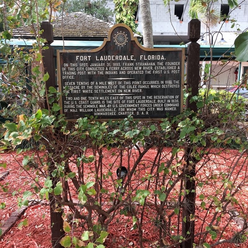
On this spot, January 31, 1893, Frank Stranahan, the founder of this city, conducted a ferry across New River, established a trading post with the Indians and operated the first U.S. Post Office.
Seven tenths of a mile west of this point . . . — — Map (db m100795) HM
The prehistoric peoples of Fort Lauderdale, commonly known as the Tequesta, occupied camps as early as 500 BCE in the area now known as Sailboat Bend. By 1800, Seminole Indians and Bahamian and American settlers inhabited lands along New River. In . . . — — Map (db m100394) HM
This tablet marks the site of the Third "Fort Lauderdale" named in honor of Maj. Wm. Lauderdale, Cmdr. Tenn. Vol.
Built in 1839 under the command of Captain William B. Davidson during the Second Seminole War
First erected by the Himmarshee . . . — — Map (db m171849) HM
On this site are the remains of early area settlers, the Richards family. As a prominent Virginia Colonial family, George Richards (1727-1818) was with Washington at Braddocks Defeat (1755), and with his sons in the Revolutionary War (1776). The . . . — — Map (db m186749) HM
This is the western boundary of a reservation set aside by the treaty of Fort Moultrie and given to John Blunt (Blount) one of the six principal chiefs of the Florida Indians. The Apalachicola River was the eastern boundary. The treaty was ratified . . . — — Map (db m78029) HM
(This is Florida's first bi-lingual marker. The second language is Apalachicola Muskogee/Creek.) Apalachicola Creek Indians permanently settled Calhoun County in 1815; wars forced them out of Alabama. A new Tribal Town was built by Chief Tuskie . . . — — Map (db m48489) HM
In recognition of
Apalachicola Tribal Town
Mekko John Blount
and the Muskogee (Creek) Nation
Reservation that existed on these lands,
where this marker stands.
The Muskogee (Creek) Nation was forcefully
removed from Florida . . . — — Map (db m246849) HM
Stage Stand was a stopping place of the mail wagon run by the U.S. Army during the 1800’s. It became a cemetery by chance.
The Seminole wars lasted intermittently from 1818 until 1858. During that time American settlers moved in to hunt and . . . — — Map (db m175841) HM
More than 1,500 soldiers died and $20 million was spent in the Second Seminole War. It was the most costly of three conflicts between the U.S. and the Seminoles in Florida. Fought from 1835–1842, the war broke out when Seminoles resisted . . . — — Map (db m101818) HM
Prior to the Spanish arrival in the 1500s, there were hundreds of thousands of Native Americans living in Florida. Evidence of their diverse culture has been discovered in the mounds, earthworks, middens and other archaeological sites found . . . — — Map (db m132271) HM
Fort Cooper was constructed in April 1836 during the Second Seminole War. General Winfield Scott instructed the First Georgia Battalion of Volunteers under the leadership of Major Mark Anthony Cooper to build two bastions and a blockhouse on the . . . — — Map (db m93258) HM
Setting the Scene In the Spring of 1836, President Andrew Jackson ordered General Winfield Scott, commander of the U.S. Army in Florida, to punish and defeat the belligerent Seminoles. Gen. Scott devised a complicated plan in which three . . . — — Map (db m132055) HM
Adapting to Life in the Cove Necessities of Life Before the Seminole were forced to move to the Cove, they were farmers and ranchers who lived in sturdy log homes and based their wealth on large herds of cattle and extensive crops. Unlike the . . . — — Map (db m132276) HM
The Siege of Fort CooperA Hastily Built Defense In March 1836, General Winfield Scott launched a campaign to surround the Seminole in the Cove with an army of approximately 5,000 men. While marching to Fort Brooke in Tampa they stopped . . . — — Map (db m132281) HM
The Second Seminole War BeginsA Year of Victory for the Seminole In the early 1830s pressure to remove Florida's Indians grew intense. Seminole leaders signed treaties in 1832 and 1833 that called for the tribe to relocate within three . . . — — Map (db m132277) HM
Fort Heilman, named after Brevet Lieutenant Colonel Julius F. Heilman, was built in the mid 1830´s at the spot where the north and south forks of Black Creek join. It was a temporary wooden stockade used during the First Seminole War as a . . . — — Map (db m102605) HM
Middleburg developed in the early 1800s as a transportation center linking the St. Johns River with the peninsular interior. Originally settled in the 1820s as Clark´s Ferry, a crossing on Black Creek, it became a major military entrepot during the . . . — — Map (db m102459) HM
The Medal of Honor is the highest military award for personal bravery or self-sacrifice that can be given to any individual in the United States of America. It has only been awarded 3,428 times in the nation’s history.
Adam Paine . . . — — Map (db m179329) HM WM
In the early 1800s, the Seminole tribe sought and found refuge deep in the bald cypress forests of Southwest Florida during the Seminole Wars. This tree bears the Seminole name for big cypress, Asteenahoofa. It is straight, solid and free of . . . — — Map (db m164916) HM
Built as the park caretaker’s residence about 1940. County Commissioner D. Graham Copeland managed Barron Collier's businesses and surveyed Collier County. He located the sites of several Seminole war forts, old trails, and Seminole villages. As . . . — — Map (db m194878) HM
As white settlers moved into Florida, demands increased for the removal of the Seminole Indians to a western reservation. The Seminoles failed to cooperate, and in 1835 the conflict known as the Second Seminole War began. By 1841, the Indians . . . — — Map (db m72605) HM
On December 26, 1817, U.S. Secretary of War John C. Calhoun directed General Andrew Jackson to protect citizens trying to settle in Florida. Jackson arrived in Florida with the largest army ever to invade the state to date -- 2,000 Creek Warriors . . . — — Map (db m61566) HM
Inhabited by the Upper Creeks, Oldtown, often called Suwanee Oldtown, was one of the largest Indian villages in northern Florida. In Andrew Jackson's punitive expedition into Florida in April, 1818, Oldtown was captured. Most of the renegade Indians . . . — — Map (db m17712) HM
Captain Francis Langhorne Dade, U.S. Army and his 120-man Companies A,B,D,H and N, built Fort Duval in November 1826 at the mouth of the Suwannee River. The structure was 140 by 130 feet and six feet high with portholes for firing. The fort was . . . — — Map (db m167492) HM
A legendary landmark in downtown Jacksonville, Florida, this majestic live oak tree is said to have sheltered settlers and natives during peace treaty talks. In the early 1900’s, an amusement park stood on the site, and today, it is the park . . . — — Map (db m142991)
Born in Italy in 1777, Desiderio Quina served the Spanish army in the Louisiana Infantry Regiment. He was later employed in Pensacola as an apothecary for the John Forbes Company where he married Margarita Bobe. His son Desiderio was born in 1817 . . . — — Map (db m80044) HM
Born on the island of Trinidad in 1812, Stephen Mallory's family eventually made Key West their home. Mallory studied law, volunteered in the Florida militia during the second Seminole War, and became Inspector of Customs at Key West. In 1830 . . . — — Map (db m80042) HM
In the early 1800s, revolution and unrest loosened Spain's control over its colonies in the western hemisphere. As Spain dealt with greater crises elsewhere, Spanish Florida became vulnerable to British forces and their Native American allies, as . . . — — Map (db m183447) HM
In the closing phases of the First Seminole War (1817-1818), a U.S. supply boat was attacked by Creek Indians. The boat was ascending the Escambia River from Pensacola in Spanish West Florida, and was bound for Fort Crawford in the American Alabama . . . — — Map (db m242608) HM
In 1886 the U.S. Army exiled 400 Apaches from the Southwest to Florida and sent most of them to Fort Marion in St. Augustine. Several Pensacola citizens, however, petitioned the government to imprison Geronimo, a medicine man and warrior, and 15 . . . — — Map (db m86084) HM
The last step in producing sugar on my plantation involved getting it ready to ship north to market. Once the molasses drained from the hogsheads in the curing room, slaves transferred both the sugar and the molasses to this loading area between . . . — — Map (db m234835) HM
This was the largest sugar mill in Florida. It was operated by Charles William Bulow and John Joachim Bulow from 1820 until it was burned by the Seminoles in 1836.
Sugar cane was planted in January and February and was ready for harvesting by . . . — — Map (db m100525) HM
The Bulow Ville plantation house was built in the early 1820s and believed to have resembled the mansion shown. The two and a half story building faced Bulow Creek and had a veranda on all sides. The first floor walls were coquina covered with . . . — — Map (db m191597) HM
This is a representation of the plantation house that once stood here. The house was built in 1821 and completely destroyed during the Second Seminole War in late January 1836.
The house was once visited by naturalist John James Audubon on . . . — — Map (db m191592) HM
Joseph Hernandez was a significant person in early Florida, with a fascinating life. Part of it was spent at his Mala Compra Plantation, and the main buildings were located on this site.
Planter
Joseph Hernandez acquired three . . . — — Map (db m208294) HM
Joseph Martin Hernandez (1788-1857) purchased and worked Mala Compra Plantation, originally a Spanish land grant, from 1816 to 1836. The name Mala Compra means “bad bargain” or “bad purchase” in Spanish. It served as the . . . — — Map (db m99955) HM
Seminoles Become Residents of Florida
Groups of lower Creeks began moving into Florida from central Georgia about 1715. Fifty years later they had established a separate identity as Seminoles. Seminoles were not a united tribe but a group . . . — — Map (db m209524) HM
General Joseph Hernandez owned three plantations along the Matanzas River. They were named Belle Vista, Byck's Hammock, and Mala Compra. The latter was his principal plantation and residence. The publicly-owned Mala Compra Plantation Greenway is . . . — — Map (db m212306) HM
(obverse)
Francis the Prophet, whose Indian name was Hillis Hadjo, was an important Creek chief who was forced to leave his home in the Alabama Territory at the end of the Creek War of 1813-14. He established a new town on the Wakulla River . . . — — Map (db m114624) HM
Side A
Built in 1814 by Lieutenant Colonel Edward Nichols, His Majesty's Marines, as a rallying point to encourage the Seminole Indians to ally themselves with England against the United States in the War of 1812. Abandoned after 1814, . . . — — Map (db m116355) HM
The Apalachicola Arsenal, originally known as the Mt. Vernon Arsenal, was built by the United States Army and served as an arms depot during the Second Seminole Indian War. Construction began in 1832, and was completed in 1839. The original compound . . . — — Map (db m79625) HM
The Apalachicola Arsenal, originally known as the Mt. Vernon Arsenal, was built by the United States Army and served as an arms depot during the Second Seminole Indian War. Construction began in 1832, and was completed in 1839. The original compound . . . — — Map (db m79626) HM
This prehistoric mound is the largest of seven that once stood here at River Landing Park. Believed to date from the Fort Walton time period (A.D. 900-A.D. 1500), its original appearance was that of a flat-topped pyramid. Archaeologists believe that . . . — — Map (db m110893) HM
The wooden wrecks visible along the shoreline here are all that remain of once luxurious paddlewheel steamboats that plied the Apalachicola River from 1820s to the 1930s.
Marine archaeologists documented a large number of these vessels between . . . — — Map (db m230791) HM
The First Seminole War erupted when U.S. soldiers attacked the Lower Creek village of Fowltown near today's Bainbridge, Georgia, on November 21-23, 1817.
Native American and Maroon (escaped slave or Black Seminole) warriors retaliated by . . . — — Map (db m230902) HM
A bloody battle fought on this site more than 200 years ago helped assure that Florida would become part of the United States.
Angered over an attack by American soldiers on the Lower Creek village of Fowltown near today's Bainbridge, Georgia, . . . — — Map (db m231593) HM
The first U.S. defeat of the Seminole Wars took place here on November 30, 1817. Several hundred Seminole, Creek and maroon (Black Seminole) warriors came to this site following raids by U.S. troops on the Creek Indian village of Fowltown near . . . — — Map (db m113147) HM
Located just north of this point is the Dr. Malcolm Nicholson Plantation Home. Built in the 1820's, it is one of the oldest remaining structures in Gadsden County. It is a one-story Gulf coast Cottage, with end-gables and a built-in porch. It rests . . . — — Map (db m157927) HM
Fort Fanning was built in 1838 during the Second Seminole War.
The fort was originally called "Palmetto", but was renamed in honor of Colonel Alexander Campbell Wilder Fannin (1788-1846).
Made of real wood, and situated in warm humid . . . — — Map (db m67884) HM
Although residents living here have always been somewhat insulated, outside influences such as war and conflict have historically influenced the Town of White Springs. The Spanish, French, British, and Americans all fought wars to own the peninsula . . . — — Map (db m44512) HM
This leisurely 10 minute, 1/4 mile long trail will lead you to the site of Fort Chokonikla built in late 1849. It consisted of three square blockhouses for defense, and canvas tents for sleeping. No battles were fought here and it was abandoned . . . — — Map (db m62019) HM WM
Named in honor of Lt. George C. Hartsuff 2nd Artillery, U.S.A., whose detachment of men were ambushed in the Big Cypress Swamp, December 20, 1855, by the Seminole Indians killing several men and wounding many others.
Fort Hartsuff was a . . . — — Map (db m110528) HM
One of the Last Battles fought with the Seminole Nation ended here on June 16, 1856 with Defeat of the Indians by Soldiers from Ft. Meade. — — Map (db m61059) HM
The combined pressure of growing white settlement in Florida and federal policy of relocating Indian tribes west of the Mississippi sparked the outbreak of the 2nd Seminole War in 1835. Controlling the coasts and campaigning in the heart of Seminole . . . — — Map (db m128831) HM
LaBelle's history begins here, along the Caloosahatchee River, on this old Fort Thompson site. Fort Thompson began c.1838 as a military post during the 2nd Seminole War, named for Lt. Colonel Alexander Thompson, who died in the battle of Okeechobee . . . — — Map (db m127268) HM
The interior of Central Florida opened for settlement by whites in the mid-1840s following the end of the Second Seminole War. In the absence of roads and railroads, coastal and inland waterways provided the transportation routes essential to . . . — — Map (db m67109) HM
Col. Zachary Taylor had Fort Basinger built in 1837, during the Seminole Wars, on the Kissimmee River 17 miles above its mouth. It was a small stockade which served as a temporary fort and supply station on the line of forts extending from Tampa to . . . — — Map (db m54083) HM
1st Lt. Irving McDowell, 1st Artillery USA. Later Major General & Commander of Union Forces at the Battle of Bull Run (Manassas). Garrisoned this fort in June 1850. — — Map (db m151007) HM
The Seminole Nation fights for their identity and their homes.
This war was fought while Florida was still a Spanish colony; it passed to the Americans in 1821. — — Map (db m193910) HM WM
During the Second Seminole War (1835-42) the U.S. Army established a cemetery at this site for soldiers, civilian employees, and Indians. In 1883, about 20 soldiers were removed to Barrancas National Cemetery, Pensacola. In time the grave sites . . . — — Map (db m44689) HM
Fort Brooke (Tampa)
Established 1824 by Col. George M. Brooke 4th US Infantry, east bank Hillsborough river. Prominent as Army Headquarters Seminole Indian Wars of 1835-42 & 1855-58.
Confederate Battery
A parapet mounted by three . . . — — Map (db m130076) HM
The Old Military Road connecting Ft. Brooke (Tampa) and Ft. King (Ocala) ran through this vicinity. On Dec. 23, 1835, Maj. Francis L. Dade set out over the Trail with a detachment of 109 soldiers to reinforce the small garrison of Ft. King.
On . . . — — Map (db m126035) HM
At this site, 407 East Street, was the home of John Thomas Lesley, built in 1897. Pioneer settler, soldier, statesman and entrepreneur, Lesley (1835 - 1913) was one of Tampa's greatest early leaders/ A native of Madison County, Florida, he came in . . . — — Map (db m54132) HM
Side 1
Commanded from here, 1838-1840
the United States Army
in the 2nd Seminole Indian War
Erected by the Hillsborough County Historical Commission 1966
Monument restored by Hart with the Streetcar Extension in 2010
. . . — — Map (db m103266) HM
On this site was located the first cemetery for Fort Brooke, a U.S. military post dating from 1824 to 1882. Seminole Indians, soldiers and civilian settlers buried here were excavated by archaeologists in 1980 prior to construction of the parking . . . — — Map (db m44377) HM
United States’ Indian Removal Policy brings on another conflict.
Major Dades command from Fort Brooke, Tampa, was attacked and destroyed by Seminole warriors
[Captions:]
Brigadier General Thomas Sidney Jesus . . . — — Map (db m193858) HM WM
Both the American soldier and the Seminole warrior experience difficult and dangerous situations during these conflicts.
Casualties for the combatants were most often the results of injury or disease, not combat wounds. — — Map (db m193866) HM WM
Provoked by state and federal Indian policy, bands of Seminoles executed attacks on isolated white settlements.
[Caption:]
Fighting in South Florida, U.S. Navy and Marine veterans fight the Seminoles in the . . . — — Map (db m193861) HM WM
Both the American soldier and the Seminole warrior faced each other across a wide cultural gap. Each were trained and determined.
A large part of central Florida is established as Hillsborough County in 1834. — — Map (db m193913) HM WM
Young American and Seminole veterans gave their energy, their skill, and sometimes their lives to their respective peoples.
Honor their memory! — — Map (db m193867) WM
Old Fort King Trail is near the original Fort King Road. During the Second Seminole War, Fort King Road served as the main transportation and communication route between Fort Brooke (Tampa) and the Seminole Agency at Fort King (Ocala). Following an . . . — — Map (db m126033) HM
For centuries, Tocobaga Indians drew water from this deep natural spring. When U.S. Army troops arrived in 1824, they quickly discovered this natural resource. Twice a day, government wagons hauled water to Fort Brooke. Despite a strong taste of . . . — — Map (db m130374) HM
A few miles southwest of this marker is the site of Fort Vinton. As white settlers moved into Florida, demands increased for the removal of the Seminole Indians to a western reservation. The Seminoles did not wish to leave, and in 1835 the conflict . . . — — Map (db m212677) HM
Creek Town of the Spanish Era
Ekanachatte ("Red Ground") was an important Creek Indian town that stood here at Neal's Landing Park during the latter half of the 18th century and the first two decades of the 19th.
This site was known as . . . — — Map (db m201244) HM
American desire for the acquisition of Florida grew after 1800 as U.S. frontiers expanded. Border incidents provided motivation for General Andrew Jackson's 1818 expedition against Florida's Seminole Indians. Jackson's army destroyed Indian . . . — — Map (db m167155) HM
Located on the west bank of the St. Johns, Ft. Butler was built in 1838 during the Seminole Wars. It consisted of a crude log stockade and barracks for the garrison. The Fort was one of the military installations designed to protect the St. Johns . . . — — Map (db m31341) HM
During the Second Seminole War (1835-1842), troops under the command of Brig. Gen. Abraham Eustis left Volusia County headed toward the Withlacoochee River as part of a military action in response to the December 28, 1835 massacre of Major Francis . . . — — Map (db m56224) HM
Near here on the Caloosahatchee River a band of 160 Indians attacked the Fort and Trading Post at four o'clock on the morning of July 23, 1839. In the raid led by Chief Chekaika of the Spanish Indians, thirteen soldiers died and fourteen, including . . . — — Map (db m127695) HM
Fort Braden was established in 1839 as a military outpost during the Second Seminole War (1835-1842). At the end of the war the fort was abandoned, but the small farming community that had developed nearby continued. A school in the Fort Braden area . . . — — Map (db m79475) HM
Mission San Luis de Talimali was among the largest and most important missions in Spanish Florida. Its parishioners were Apalachee Indians who were descendents of those people whose village Hernando de Soto appropriated during the winter of . . . — — Map (db m79564) HM
This monument is erected by his fellow citizens of Leon County, Florida, as a testimonial of their high esteem for his character and public services. The memory of the hero is the treasure of his country. He was born July 10, 1823 and was killed . . . — — Map (db m73046) HM
The oldest public building in Tallahassee. Construction was begun in 1835 and completed in 1838. Contains original slave galleries. The building was used many times as a place of refuge for women and children during Indian Wars. — — Map (db m73053) HM
The community of Chaires was established in the 1820s during Floridas Territorial Period (1821-1845). The community is named after Green Hill Chaires, who, along with his two brothers, Benjamin and Thomas Peter, came from Georgia and established . . . — — Map (db m166852) HM
Side 1
The Miccosukee Indian chief, John Hicks (English name for Tuckose Emathla) was a prominent Indian leader in the period between the First and Second Seminole Wars (1818-1835). It is believed that after General Andrew Jackson destroyed the . . . — — Map (db m210908) HM
On this site stood a Blockhouse erected by the citizens of the area to protect women, children, and old people in the threatening period of 1835-1842. It served as an informal Court House before Adoniram Vann completed the regular Court House in . . . — — Map (db m149386) HM
Near this location stood Fort Hamer, a Second Seminole War fort and hospital that stood on the south bank of the Manatee River at the highest point navigable by steamboats. The fort was part of a greater U.S. military strategy of a line of forts . . . — — Map (db m239222) HM
Side 1:
Miguel Guerrero (aka Gerrero), a Menorcan sailor (b. 1817), established a fishing rancho here at Boots Point in 1848 on the site of a prehistoric Indian village. In 1856, Miguel met Julia Atzeroth's niece, Frederica Kramer (b. . . . — — Map (db m241682) HM
In 1823, the Treaty of Moultrie Creek allocated land to the Seminole with the northern-most boundary of the reservation ending at what would soon be known as Fort King. Due to the growing friction between the Seminole and white settlers, the . . . — — Map (db m201370) HM
December 28, 1835
The start of the Second Seminole War:
The second attack on that deadly day
Attack on Fort King
The same day as the Dade Massacre, the Fort King Indian Removal Agent, General Wiley Thompson, was anticipating . . . — — Map (db m201752) WM
Dade Massacre
Dec. 28, 1835
Major Francis L. Dade and 110 men were attacked six miles north of Withlacoochee River. Four survived and one lived to tell the story. Troop was en route to Ft. King.
Same day, Gen. Thompson and . . . — — Map (db m198813) HM WM
December 28, 1835
The start of the Second Seminole War:
The first attack on that deadly day
Dade Massacre
On December 23, 1835, two companies of U.S. troops were dispatched from Fort Brooke in Tampa under the . . . — — Map (db m201516) HM
Florida Armed Occupation Act
8-4-1842 • 238 Signers
East of base line near Fort King a quarter
section of land for the head of a family,
or a single man over eighteen years of
age, able to bear arms
Sponsored by: . . . — — Map (db m198634) HM WM
Some of the early migrants to the Greenway were known for whips and storytelling. Discover what happened. Discover The Island. Florida’s Crackers were mostly, it's said to be, English pioneer settlers and their descendants who began coming to . . . — — Map (db m167205) HM
Florida Seminole. After the Third Seminole War (1858), nearly 3,000 Indians were forcibly sent to the Oklahoma Territory. A small number of Seminoles continued to live in relative isolation in southern Florida into the 1900s. Flood control and . . . — — Map (db m167203) HM
Early Migrants More Than Snowbirds The earliest migrants to Florida, determined by archeological evidence, date back to 500 A. D. Among them were the Deptford People, the Weeden Island People, the St. John's People and the Timican . . . — — Map (db m167202) HM
Fort Brooke - Tampa, Florida in 1847 & 48 two infantry companies of Florida volunteers restrained the Indians in South Florida while three infantry companies of volunteers went to the Mexican American War.
Dedicated to my great, great . . . — — Map (db m199009) WM
2903 entries matched your criteria. Entries 301 through 400 are listed above. ⊲ Previous 100 — Next 100 ⊳