By Mark Hilton, January 14, 2017
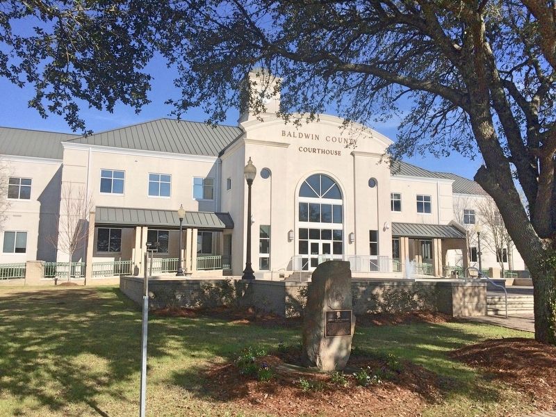
Plaque and stone in front of the Baldwin County Courthouse.
GEOGRAPHIC SORT WITH USA FIRST Geographic Sort Title Sort Marker Number Sort Marker Number Sort for Trails Publication Order Sort Publication Order Sort A Erected Year Sort Most Viewed Sort Most Recent-Interest Sort Most Recently Changed Sort SEE FAQ #33 FOR DESCRIPTIONS
On Courthouse Square (U.S. 31) at Hand Avenue, on the left when traveling west on Courthouse Square.
On Franklin Street 0.1 miles north of Washington Avenue, on the left when traveling north.
On Franklin Street 0.1 miles Washington Street, on the left when traveling north.
On Nern Street, on the right when traveling east.
On Eufaula Avenue (Alabama Route 198) at South Armory Street, on the right when traveling east on Eufaula Avenue.
On North Midway Street, on the right when traveling south.
On Elamville Street (Alabama Route 10), on the right when traveling west.
On U.S. 82 just west of Silo Road, on the right when traveling east.
On West Broad Street east of Sanford Avenue, on the right when traveling east.
On East Barbour Street (U.S. 82), on the right when traveling east.
On West Broad Street, on the right when traveling west.
On Springhill Road, on the left when traveling west. Reported missing.
On Main Street (U.S. 231) at Lee Street West, on the left when traveling north on Main Street.
Paid Advertisement
On Lee Street (County Road 26), on the right when traveling west.
On State Highway 79 at Hornet Drive, on the right when traveling south on State Highway 79.
On Second Avenue East (US Highway 231) at 4th Street North, on the right when traveling west on Second Avenue East (US Highway 231).
On U.S. 82 near Greenwood Avenue, on the right when traveling west. Reported damaged.
On East 10th Street west of Kirkwood Avenue, on the left when traveling east.
On Noble Street at East 12th Street, on the right when traveling north on Noble Street.
On Ladiga Street Southeast, on the right when traveling east.
On Public Square East (State Highway 21) west of Ladiga Street Southeast, on the left when traveling north.
On Public Square West (State Highway 21) east of Ladiga Street Southwest, on the left when traveling south.
On Pelham Road (State Highway 21) at 5th Street NE, on the right when traveling north on Pelham Road.
On Public Square East (State Highway 21) south of Clinton Street Southeast, on the left when traveling north.
On East Ladiga Street east of North Center Avenue, on the right when traveling west.
On Cedar Bluff Road (State Road 283) north of West Main Street (Business U.S. 411), in the median.
On County Road 97 0.2 miles north of Main Street (State Route 68), on the left when traveling north.
On 2nd Avenue North west of 5th Street South, on the right when traveling west.
On Indian Way (County Road 5) at State Route 17, on the right when traveling east on Indian Way.
Paid Advertisement
On U.S. 84 at Gosport Landing Road, on the left when traveling west on U.S. 84.
On Court Street near Main Street, on the right when traveling south.
On Berrys Chapel Road 0.7 miles north of Winn Road (Route 3), on the right when traveling north.
Near Court Square (Road 31) at 2nd Avenue North, on the right when traveling south.
On Alabama Route 9 at Main Street, on the left when traveling north on Alabama Route 9.
On Vickery Street at Hunnicutt Street, on the right when traveling south on Vickery Street.
On Putnam Street at Court Street, on the right when traveling east on Putnam Street.
Near Putnam Street at Court Street.
Near Natchez Trace Access Road (at milepost 327.3), 0.4 miles west of Natchez Trace Parkway, on the right when traveling west.
On South Montgomery Avenue at West 1st Street, on the right when traveling south on South Montgomery Avenue.
On S. Main Street close to 4th Street, on the right when traveling south.
On South Cave Street at East 7th Street, on the right when traveling north on South Cave Street.
On South Main Street at Spring Park Road, on the left when traveling south on South Main Street.
On North Commons Street East east of North Dickinson Street, on the right when traveling east.
On SW 14th Avenue near SW 7th Street, on the right when traveling east.
Paid Advertisement
Near County Road 5 at County Road 15.
On County Road 5 1.2 miles north of County Road 30, on the right when traveling north.
On County Road 15 1 mile south of County Road 5, on the right when traveling south.
On County Road 5 2 miles north of Conecuh County (County Road 30), on the right when traveling north.
Near County Road 15 0.2 miles south of Doe Lane.
On County Road 5 0.7 miles south of County Road 2, on the right when traveling north.
On East 3 Notch Street at 6th Avenue, on the right when traveling west on East 3 Notch Street.
On County Road 747 0.1 miles south of County Road 1508, on the left when traveling south.
On Wesley Avenue (County Road 1669) at Lions Park Road, on the right when traveling west on Wesley Avenue.
On Z Street (Local Route 47) at County Road 1, on the left when traveling east on Z Street.
On Alabama Route 134 at Parramore Road, on the right when traveling east on Alabama Route 134.
On College Street (Alabama Route 134) at Queen Street, on the right when traveling south on College Street.
On Andrews Avenue (Alabama Route 249) west of Meadowlake Drive, on the right when traveling west.
On East Broad Street (Alabama Route 27) 0.2 miles east of Union Street ( Route 123), on the right when traveling east.
On Painter Avenue at Owens Street, on the right when traveling south on Painter Avenue.
On North Union Avenue (Alabama Route 123) at Broad Street ( Route 27), on the right when traveling south on North Union Avenue.
Paid Advertisement
On Painter Avenue at Owens Street, on the right when traveling south on Painter Avenue.
On Capitol Street, on the right when traveling east. Reported permanently removed.
On Oak Street north of Fifth North Street, on the left when traveling north.
On Union Street at Furniss Avenue, on the left when traveling north on Union Street.
On Broad Street (Business U.S. 80) at Water Avenue, on the right when traveling north on Broad Street.
On Water Avenue at Lauderdale Street, on the left when traveling west on Water Avenue.
On Alabama Avenue east of Mabry Street, on the right when traveling east.
On Broad Street (U.S. 80), on the right when traveling north.
On Tremont Street, on the right when traveling south.
On Tremont Street at McLeod Avenue, on the right when traveling south on Tremont Street.
On Kings Street south of Dallas Avenue (State Highway 22), on the right when traveling south.
Near Little River Falls Overlook Trail 0.1 miles west of Route 35.
On Coosada Road at Auburn Hill Road, on the right when traveling west on Coosada Road.
On Main Street (Alabama Route 143) at Coosada Road, on the right when traveling north on Main Street.
On Jasmine Hill Road at Old Montgomery Highway, on the right when traveling south on Jasmine Hill Road.
Paid Advertisement
On Belleville Avenue at Court Street, on the right when traveling south on Belleville Avenue.
On Manassas Street at Misella Street on Manassas Street.
On Cabot Avenue at Dwight, Winona, & Lakefront Aves. & Coolidge Cir., on the right when traveling north on Cabot Avenue.
On Forrest Avenue at South 8th Street, on the right when traveling east on Forrest Avenue.
On Broad Street near South 1st Street.
On Main Street (U.S. 11) near Springfield Avenue, on the right when traveling west.
On Hobson Street at Main Street, on the left when traveling north on Hobson Street.
On East Laurel Street near South Broad Street (State Route 279), on the right when traveling east.
On South Scott Street north of East Charlotte Avenue, on the left when traveling north.
On Lee Highway/John T. Reid Parkway (State Highway 2/72) at County Road 7, on the left when traveling west on Lee Highway/John T. Reid Parkway. Reported missing.
On Arlington Avenue at 19th Street South, on the right when traveling west on Arlington Avenue.
Near 3rd Avenue North near Richard Arrington Jr, Blvd North.
On Richard Arrington Junior Boulevard North north of 3rd Avenue North.
Near Richard Arrington Junior Boulevard North.
Paid Advertisement
On 6th Avenue North at 24th Street North, on the left on 6th Avenue North.
On Cahaba Road at Park Lane, on the right when traveling north on Cahaba Road.
On 1st Avenue North (U.S. 11), on the right when traveling north.
On Vestavia Drive east of Beaumont Drive, on the left when traveling east.
On East Main Street (U.S. 278) at Bankhead Street, on the right when traveling east on East Main Street.
︽
10602 entries matched your criteria. The first 100 are listed above.
Next 100 ⊳