On East Guardian Street, on the right when traveling south.
Male and Female High School Site
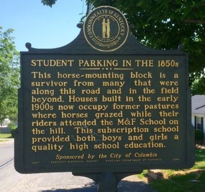
The Columbia College Joint Stock Company formed in 1853 to build the M&F School. It was conveyed to trustees appointed by Transylvania Presbytery and opened in 1855. The building was a Union Camp during . . . — — Map (db m170509) HM
On East Woodford Street (U.S. 62) near Dogwood Drive, on the left when traveling east.
Kavanaugh School.
Rhoda C. Kavanaugh founded school on Woodford Street which became known as "Little Annapolis." First boarding student came to prepare for Naval Academy in 1914. From then until 1945, Mrs. Kavanaugh launched 150 future Navy . . . — — Map (db m236572) HM
On East Woodford Street (U.S. 62) east of Dogwood Drive, on the right when traveling west.
Kavanaugh Academy 1904-09; Anderson Co. High School 1909-20; Kavanaugh High School 1920-49. Rhoda C. Kavanaugh, A.B., founder and principal 41 years. Under her direction it ranked among the nation's foremost preparatory schools for Annapolis and . . . — — Map (db m236573) HM
On West Broadway Street (U.S. 62) at Old Frankfort Road (U.S. 127), on the right when traveling west on West Broadway Street.
This renowned scholar, raconteur, and lawyer was born in Anderson Co. Educated first in a one-room school at Glensboro, he graduated from U.K. Law School in 1912. Among his books was Lincoln and the Bluegrass (1955). His talk on Cassius Clay, . . . — — Map (db m34786) HM
On Coral Hill-Lecta Road at Coral Hill Road (Kentucky Route 740), on the right when traveling east on Coral Hill-Lecta Road.
In 1855, John and Francis Marion Jones formed a partnership for selling goods at Myers Steam Mill on Beaver Creek in Barren County. A petition for a post office was granted in 1856 & name changed from Myers Mill to Coral Hill. Store was catalyst . . . — — Map (db m143082) HM
On Tompkinsville Road (Kentucky Route 63) at Bristletown Road, on the left when traveling north on Tompkinsville Road.
Henry Clay Morrison
Famed Methodist preacher & pioneer of the Holiness movement. He came to Barren Co. at age 2 & was raised by his grandparents near here. He became one of nation’s premiere evangelists and was editor of the Pentecostal Herald . . . — — Map (db m143080) HM
On Washington Street / South Public Square at South Race Street, on the right when traveling east on Washington Street / South Public Square.
Born in Hiseville (Barren Co.). Graduate of Kentucky State Univ.; later member of Board of Regents. Also studied at Indiana Univ. and Peabody Coll. As principal of Ralph J. Bunche School, Twyman led its merger with Glasgow High School to achieve . . . — — Map (db m82469) HM
On Race Street at Washington Street, on the left when traveling south on Race Street.
(Front Side)
The first female public official in Barren Co., she was elected in 1913, seven years before women were allowed to vote. She was Barren Co. schools superintendent from 1914-1917. Instrumental in unifying local schools to . . . — — Map (db m88116) HM
On State Highway 190 at U.S. 25E, on the right when traveling east on State Highway 190.
Rev. Hiram M. Frakes founded this Methodist Settlement in 1925. Begun in a cabin with 13 students, it became an institution for spiritual and educational development of mountain youth. Frakes guided and influenced the entire Middle Laurel Fork . . . — — Map (db m162490) HM
On Main Street, 0.1 miles north of East 11th Street, on the right when traveling north.
Although it was a military academy,
its goal was to educate young men &
women in a structured, disciplined,
and challenging environment to
prepare them for leadership roles
in military or civilian life. Army
Cadet Corps purchased property in . . . — — Map (db m217853) HM
On High Street (U.S. 460) south of Ardery Place, on the left when traveling south.
Born September 23, 1800-Died May 4, 1873 Famous for his eclectic readers which introduced thousands of children to the treasures of literature. At this site he taught from 1823 to 1826 before joining the faculty of Miami University. — — Map (db m50653) HM
On 15th Street at Greenup Avenue (Kentucky Route 23), on the left when traveling north on 15th Street.
The Booker T. Washington School was built in 1903 for grades 1-8. By 1931 it included a four year high school at its Central Ave & 7th ST location. All Boyd Co. schools were not integrated until 1962. In that year, Booker T. Washington closed. We . . . — — Map (db m228066) HM
On Central Avenue at 8th Street, on the left when traveling west on Central Avenue.
In 1894 Ashland Board of Education assumed management of “Negro School,” where African American William Reynolds was principal. In 1901 a bond issue passed with support of blacks and Superintendent J.G. Crabbe. School board then funded . . . — — Map (db m127190) HM
This stadium served the Ashland Public Schools. Built in 1937 for $6,500 as a WPA project, it was dedicated on Thanksgiving Day that same year. The Ashland High School Tomcats record of success includes 11 state championships. In 1944, the Tomcats . . . — — Map (db m73802) HM
Boyd County was created in 1860 from parts of Greenup, Carter, and Lawrence and lies at a point where Ohio, West Virginia and Kentucky meet. Linked to Ohio by two bridges over the Ohio River and with two more to West Virginia (across the Big Sandy . . . — — Map (db m73756) HM
On 28th Street at Panola Street, on the right when traveling west on 28th Street.
The first woman elected to Kentucky
legislature, 1921. Mary E. Flanery
elected to House of Representatives
from Boyd County. She had worked
for woman suffrage; was concerned
with marriage and divorce laws
and educational reform. At her
death, . . . — — Map (db m126102) HM
On College Street, on the left when traveling north.
Colorful college football coach and National Baseball League umpire. Coached Praying Colonels of Centre College into national football spotlight, 1916-23. See other side. First coached, 1898-99, at Bethel College, Russellville, Ky. Then held four . . . — — Map (db m121575) HM
This one-story brick building, originally only two rooms, was the first brick schoolhouse in Danville. The schoolhouse, circa 1820, was renovated in 1975. — — Map (db m121729) HM
On West Main Street, on the left when traveling west.
Founded on this campus in 1819 by pioneer Kentuckians who held that heart and mind must be trained together, and dedicated to the inculcation of ideals of culture and character in the hearts of American youth. Veritas Lux Mentis. — — Map (db m121562) HM
On South 3rd Street at Jacob Street, on the left when traveling north on South 3rd Street.
On June 1, 1916, representatives of local churches, civic clubs and Centre College, inspired by Hull House and the Progressive Era, founded the Community Work Board (CWB), which made social work scientific, opposed begging; gave coal, meals, and . . . — — Map (db m170098) HM
On South Second Street, on the left when traveling north.
Kentucky School for the Deaf first opened 1823 in Danville, at 4th and Main Sts. In 1826, it moved to this campus. Jacobs Hall is oldest surviving building, constructed 1855-57, of Italianate design by architect Thomas Lewinski. Its interior is . . . — — Map (db m121561) HM
On Stanford Ave (Kentucky Route 150), on the left when traveling north.
Side 1 Original site of Bate High School, built 1912 and named in honor of its founder, John William Bate. Born a slave in Louisville, Bate received an AB from Berea College in 1881 and and AM in 1891. He moved to Danville to teach in 1881 . . . — — Map (db m105414) HM
On North Danville Bypass (Bypass Route 127) 0.2 miles north of Lannock Drive, on the right when traveling north.
This dynamic Southern Baptist missionary spent almost forty years (1873-1912) teaching and ministering in China. She was a member of First Baptist Church, Danville, 1868-71, and taught at Caldwell Female Institute, later a part of Centre College. . . . — — Map (db m153068) HM
On West Main Street at South Fourth Street, on the right when traveling east on West Main Street.
On this corner, in 1823, Kentucky founded the first state-supported school in the United States for the instruction of deaf children. Classes met in an old inn that was known as the Yellow House. Reverend and Mrs. John R. Kerr served as first . . . — — Map (db m121541) HM
On Heather Renee French Boulevard (Kentucky Route 8) at Frankfort Street, on the right when traveling west on Heather Renee French Boulevard.
Stephen Collins Foster, as youth, visited here, May 1833. His uncle, Dr. Joseph S. Tomlinson, was then President of Augusta College. The musical, harmonious voices from the old Negro church on the hill floated softly over the town. “It can . . . — — Map (db m136271) HM
On Frankfort Street north of East 3rd Street, on the right when traveling south.
In 1822 the trustees of Bracken Academy with conferences of the Methodist Church of Kentucky and Ohio, merged to found Augusta College. The first established Methodist college in the world. — — Map (db m85801) HM
On West Riverside Drive at Williams Street, on the right when traveling east on West Riverside Drive.
This log cabin was built using white oak logs cut in 1797, with the oldest log displaying a growth ring from 1690. It is believed to be the oldest school building still standing in the tri-state region. Due to its larger size and high-quality . . . — — Map (db m217843) HM
On Bradford Road (Kentucky Route 1109) south of Mary Ingles Highway (Kentucky Route 8), on the left when traveling south.
A rare example of a one-room schoolhouse. First through eighth grades, with about 25 children per year, were taught by one teacher. This schoolhouse was used until 1929. In Kentucky there were an estimated 6,752 one-room schoolhouses in 1901, and . . . — — Map (db m136270) HM
On Bridgeville Road (Kentucky Route 875) south of Brooksville-Germantown Road (Kentucky Route 10), on the right when traveling south.
John Gregg Fee. Fee received degree from Augusta
College; went to Lane Theological
Seminary. Had spiritual experience
which began career as nationally
known and determined abolitionist.
A founder of Berea College who
wanted low-cost . . . — — Map (db m136344) HM
Near North Main Street at East Ohio Street, on the right when traveling north.
Born Jan. 27, 1867, two miles NE of here. Educated in local schools. B. A. from National Normal Univ., Ohio. He taught school for 6 years. Studied in Germany and earned a Ph.D. from Yale in 1895. Began ministry in Methodist Episcopal South. . . . — — Map (db m123454) HM
On U.S. 62 at West Main Street, on the right when traveling west on U.S. 62.
Site of college founded March, 1826, by the Cumberland Presbyterian Church. First president was Rev. F. R. Cossitt. School opened with six students on some 500 acres of land bought for $6,000. A manual-labor school, students required to work 2 hours . . . — — Map (db m123805) HM
On North Plum Street at West Main Street, on the right when traveling south on North Plum Street.
Six educational institutions have flourished here since 1860. Local citizens gave $20,000 and Dr. T.L. McNary six acres to establish Princeton College, 1860-80. Youth also served by Princeton Collegiate Inst., 1880-1911; Princeton High, 1911-23; . . . — — Map (db m123800) HM
On North Donnivan Street at Calvert Street, on the right when traveling north on North Donnivan Street.
In 1910, Princeton High School was the only high school in the vicinity for blacks. In 1920s name was changed to Dotson High School in honor of John Dotson, a prominent black businessman in Princeton. In 1938, Federal WPA officials approved . . . — — Map (db m166066) HM
On Hopkinsville Street (State Road 91) at University Drive, on the right when traveling south on Hopkinsville Street.
Established by Ky. legislature in 1924 as Western Ky. Sub-experiment Station of the Univ. of Kentucky College of Agriculture. Original 400 acres donated by Caldwell Co.
citizens. S. J. Lowry was supt., 1924-63. First office / service building was . . . — — Map (db m158710) HM
On Kirksey Road (Kentucky Route 299) 0.2 miles south of Backusburg Road (Kentucky Route 464), on the right when traveling south.
This institution of higher learning was established by 1899 under the leadership of Rainey T. Wells, later president of Murray State Teachers College. Land for college was deeded to trustees in 1899. Students came from a wide area and boarded in . . . — — Map (db m169149) HM
On North 16th Street, 0.1 miles north of Miller Avenue, on the right when traveling north.
Murray native Cleanth Brooks became a major figure in the teaching and study of literature. With fellow Kentuckian Robert Penn Warren, he co-founded the Southern Review and directed attention to close reading of literature -- the "New . . . — — Map (db m169171) HM
Near North 15th Street at Olive Boulevard, on the left when traveling north.
Shortly after the historic U. S. Supreme Court Brown v. Board of Education, et. al. decision, Murray State College "with all deliberate speed," welcomed Mary Ford Holland of Kuttawa, Ky., as a student in the summer of 1955. Holland's . . . — — Map (db m179582) HM
On North 16th Street at University Drive, on the right when traveling north on North 16th Street.
Established 1922. Founder, Rainey T. Wells (1875-1958). His home, where the idea of the University was born, 350 feet SE of here. Dr. Wells second president of Murray State.
Gov. Morrow signed bill authorizing two "normal schools” — . . . — — Map (db m169173) HM
On Gil Hopson Drive (County Road 1084) 0.3 miles north of Arcadia Circle, on the right when traveling north.
This one - room school building, named for Joseph Spillman Waters (1822-1898), its first teacher, once sat near New Concord. School operated from mid -1800s to 1936. Moved here, it was preserved as a representative of the type of school building . . . — — Map (db m179562) HM
On Memorial Parkway (Kentucky Route 1120) at North Fort Thomas Avenue, on the right when traveling south on Memorial Parkway.
The oldest church congregation in Ft. Thomas. Began in the home of Wm. & Alice Taliaferro in 1830. In 1832, log structure was built for Sunday services & served as first school in the area during the week. 1850-52, frame church building was erected . . . — — Map (db m175082) HM
On Louie B Nunn Drive west of University Drive, on the right when traveling west.
Northern Kentucky University began as an
extension center of University of
Kentucky, 1948. It became community
college, 1962, and by 1976 was a
state university. It moved here
from Covington in 1972. The 300-acre NKU campus is part of . . . — — Map (db m135013) HM
On East Southgate Street east of Saratoga Street, on the left when traveling east.
In 1870, the Newport City Council purchased property for a school for African Americans, and three years later a frame house was constructed. Elizabeth Hudson was appointed first African American teacher at salary of $35 per month. Two major events . . . — — Map (db m135078) HM
On West Tom T Hall Boulevard (U.S. 60) just west of Whitt Street, on the left when traveling east.
WIA programs are done by eastern Ky. Concentrated employment program, inc. Funded by Workforce Investment Act funded by U.S. Dept of Labor by Ky. Ed. Cabinet, Div. of Work Force Services. — — Map (db m164385) HM
On Fishing Creek Road, 0.3 miles east of Jones Road, on the right when traveling east.
Site of one of the first schools in Casey Co. Est. in the 1830s in a log building, was used as church and school. Around the Civil War, school dist. divided into Durham and Utah districts. This became the Utah district school. Area districts . . . — — Map (db m244658) HM
On West 15th Street west of Bethel Street, on the left when traveling west.
Organized by the Bethel Baptist Association and opened in 1854 as Bethel Female High School. Used by CSA as hospital during Black Measles epidemic, 1861-1862. Bethel Women's Jr. College, 1917. Closed 1942-1945; rooms rented to Camp Campbell Army . . . — — Map (db m136778) HM
On Talbert Drive just west of North Elm Street, on the left when traveling west.
The Round Table and the Sword in the Stone, replicas from the Chivalric Age of King Arthur, were erected in the belief that the lofty ideals and standards of gentility that prevailed in Camelot can be renewed on the campus on Hopkinsville . . . — — Map (db m166895) HM
On West Lexington Avenue (U.S. 60) at McCann Drive, on the right when traveling west on West Lexington Avenue.
Born in Winchester, Allen Tate was a teacher and writer of prose and poetry of international fame. Also a leader of "New Criticism" poets and group known as Agrarians that supported the southern tradition. Helped found poetry magazine, "The . . . — — Map (db m164254) HM
On Town Branch Road, on the right when traveling west.
(Front): Gov. Bert T. Combs (1959-1963)
Accomplishments during Comb’s administration included highways connecting eastern and western Ky., expansion of state parks system, a statutory merit system for state employees, an end to . . . — — Map (db m49185) HM
On State Highway 66, 0.6 miles north of U.S. 421, on the right when traveling south.
(Side One)
Named in honor of first white man to settle on Red Bird River, at the mouth of Gilbert’s Creek. A veteran of Revolutionary War, John Gilbert came here to hunt and trap. He surveyed and claimed much of Clay, Leslie and Harlan . . . — — Map (db m87568) HM
On College Street south of River Street, on the right when traveling south.
The land for what became Oneida Baptist Institute was donated by Martha Coldiron Hogg and S.P. Hogg in September 1899. The school was founded by James Anderson Burns, December 20, 1899, as Mamre Baptist College to meet the social, educational, and . . . — — Map (db m39148) HM
On State Highway 1351 at Groce Gibson Road, on the left when traveling south on State Highway 1351.
Side 1:
Residents and students alike held the traditions of the school in high esteem. Two became college presidents: Drs. A. B. Mackey and T. W. Willingham. Others who gave years of service to the community well beyond the school era were Dr. . . . — — Map (db m244686) HM
On North Washington Street at Cumberland Street, on the left when traveling north on North Washington Street.
For DeWitt Clinton, 1769-1828. In New York Senate, nine years; U.S. Senate, 1802-03, where he introduced XII Amendment, present method of electing U.S. president, vice president. Mayor, New York, nine years; leader, tax supported school movement. . . . — — Map (db m136583) HM
On Carlisle Street at Court Street, on the left when traveling west on Carlisle Street.
Graduate of Dycusburg High (1927)
AB Murray State (1931)
MA University of Kentucky (1932)
PhD Clark University (1939)
War journalist, Professor, Military Biographer, Researcher, Pioneer of Oral History Techniques. Founder & President of . . . — — Map (db m244267) HM
Near Piney Cemetery Road at Kentucky Road 506, on the right when traveling west.
Organized May 1812 during the Great Awakening by Rev. Finis Ewing who preached the Whosoever Will Gospel.
The first Cumberland Presbyterian Church organized in Kentucky — — Map (db m244265) HM
On South Main Street at East Depot Street, on the right when traveling north on South Main Street.
Senator W. J. Deboe
Born 1849, eight mi. SE of here. Deboe was elected County School Superintendent and opened law office, 1889. State Senator, 1893-97. Elected by Legislature to U.S. Senate, 1897. He wrote the 17th Amendment to the U.S. . . . — — Map (db m123770) HM
On Upper River Street east of Veterans Street, on the left when traveling east.
In appreciation for his fifty four years of outstanding service to the community as a physician and as an energetic and generous supporter of many improvements which enhanced the quality of life for citizens of Cumberland County. Some of the major . . . — — Map (db m245359) HM
Near West 5th Street at Cs-1186-30, on the right when traveling west.
Every African-American family holds in high esteem women whose strength in the face of overwhelming odds provided hope and encouragement. Women have worked to strengthen their communities of family, neighborhood, school and church.
Teaching . . . — — Map (db m159345) HM
On West 4th Street at Poplar Street, on the right when traveling east on West 4th Street.
Dr. Clay E. Simpson, Sr., native of Notasulga, Alabama and his wife Mary E. Simpson, native of Fayette County, Kentucky, served the Owensboro community for many years. As a Family Physician, Dr. Simpson made numerous house calls and delivered . . . — — Map (db m160137) HM
Near West 5th Street at Cs-1186-30, on the right when traveling west.
The end of slavery in 1865 brought many challenges to Owensboro's African-American population. They struggled to find jobs, establish homes, educate their children, and find their place in the post-war world.
In 1880 a system of schools for . . . — — Map (db m159343) HM
On Kentucky Route 764 just south of U.S. 231, on the right when traveling north.
Pleasant Point Missionary Baptist Church. Six emancipated slaves formed this congregation in 1871. Three years later it was fully organized: the church erected in 1878. Membership grew as African Americans searched for religious & cultural . . . — — Map (db m159288) HM
On Main Street (Kentucky Route 89) south of Orchard Avenue, on the right when traveling south.
Estill Seminary
This site approved for Jefferson Seminary by act of Ky. General Assembly in February 1798. Name was changed to Estill Seminary, February 3, 1816. Trustees given authority to sell half of unclaimed lands, granted for educational . . . — — Map (db m136807) HM
In May 1875, an estimated 10,000 racing fans watched the first running of the Kentucky Derby. Among the field of fifteen thoroughbreds, Aristides, the “little red horse,” won the mile-and-one-half race. Oliver Lewis, a . . . — — Map (db m78750) HM
On Administration Drive at Patterson Drive, on the left when traveling north on Administration Drive.
Dedicated in 1901 and known as Alumni Hall. The original structure was a central, three-story building with a gymnasium and a drill hall on either side. Expanded in the 1930s with aid of WPA funds. The 19th-century bell from the Peter Taylor . . . — — Map (db m136988) HM
Near Hilltop Avenue north of University Drive, on the right when traveling north.
Class Competitions On American campuses in the 1900s, freshman and sophomore classes had a variety of competitions. The University of Kentucky was no exception. An early rivalry was the annual flag rush in which one class would defend their flag . . . — — Map (db m202820) HM
Near Avenue of Champions (Kentucky Route 1974) south of South Limestone (U.S. 27), on the left when traveling south.
Cleona Belle Matthews Boyd Cleona Belle Matthews, a native of Missouri, taught Greek and Latin at Park College Academy until she married Dean Paul P. Boyd in 1906 and they moved to Kentucky. The Boyds had two children, Virginia and Martha. . . . — — Map (db m218234) HM
On Hilltop Avenue north of University Drive, on the left when traveling north.
Desegregation of UK
In 1948 Lyman T. Johnson filed suit for admission to UK. In March 1949 Federal Judge H. Church Ford ruled in Johnson's favor, and that summer nearly 30 black students entered UK graduate and professional programs. . . . — — Map (db m169899) HM
On Newtown Pike (Kentucky Route 922) 1 mile north of Iron Works Pike (Kentucky Route 1973), on the right when traveling north.
Pharmacist, physician, chemist, teacher and author. Born in England, 1805, he came to Lexington in 1832. Dr. Peter was associated with Transylvania Univ. more than 50 yrs.; elected to chair of chemistry and pharmacy and Dean of Medical School. . . . — — Map (db m165195) HM
On Richmond Road (U.S. 25, 421) south of Lake Park Road, on the right when traveling south.
The home which stood on this site from 1787 to 1947 was built by Levi Todd (1756-1807), who named it for his ancestral village in Scotland. He was one of a party of hunters who named Lexington in 1775; first Fayette County clerk; aide to George . . . — — Map (db m70579) HM
On North Broadway (U.S. 27/68) north of Kenyon Road, on the right when traveling north.
Fairlawn, ca. 1845. Home of Dr. Benjamin W. Dudley from 1846 until 1870. Small white cottage to south purchased by Dr. Dudley, 1839, used for instruction in anatomy and surgery while on faculty of Transylvania Medical School. William T. . . . — — Map (db m169849) HM
On Farm Road at University Drive, on the left when traveling west on Farm Road.
Family & Consumer Sciences Extension in Kentucky Programs began in 1914 when 17 county agents were hired to focus on canning work. Early agents taught food production, safety, preservation & storage. Programs expanded through the 20th century to . . . — — Map (db m202819) HM
On Avenue of Champions (Kentucky Route 1974) north of South Martin Luther King Boulevard, on the right when traveling north.
Frances Jewell McVey
Frances Jewell, a native Kentuckian, was a
graduate of Vassar College and Columbia
University. Beginning as an instructor in the
University of Kentucky English Department
from 1915-1921, Jewell served as Dean . . . — — Map (db m169879) HM
On Administration Drive north of South Limestone (U.S. 27), on the right when traveling north.
Erected in 1889 as U.K.'s first Agricultural Experiment Station; now second oldest building on the campus. Destroyed by fire in 1891, it was rebuilt on the same site. Named for Ezra Gillis (1867-1958) who joined the U.K. faculty in 1907 and served . . . — — Map (db m136985) HM
On Huguelet Drive north of University Drive, on the right when traveling north.
The original Haggin Hall — In 1939, President Frank MeVey announced that Margaret Voorhies Haggin had created a trust fund in memory of her late husband, James B. Haggin. This gift continues to enrich the University today.
Born in Frankfort, . . . — — Map (db m169904) HM
On Huguelet Drive south of Rose Street, on the right when traveling north.
Herman L. Donovan
UK's Fourth President (1941-1956),
Donovan guided the University through
World War II and desegregation. He
focused much of his energy on post-war
planning for UK, which witnessed an
influx of returning service men . . . — — Map (db m169906) HM
Preceded by several earlier student newspapers, the first Kentucky Kernel appeared September 16, 1915. An eight-page weekly by 1923, after a varied publication schedule it became a daily newspaper in 1966. Housed in several campus locations before . . . — — Map (db m218244) HM
Lexington Courthouses
East of Cheapside is the public square, where courthouses of Lexington ahve stood since 1788. The present edifice is fifth fourthouse, the fourth on this site. It was built during 1898-1900, after fire destroyed fourth . . . — — Map (db m14018) HM
On Administration Drive, 0.1 miles S. Limestone (U.S. 27), on the right when traveling east.
Opened in 1882 and known as the Main or College Building, it contained classrooms, offices, and a chapel for student assemblies. Designed by architect H. P. McDonald and built of brick fashioned from campus clays and stone at a total cost of . . . — — Map (db m134591) HM
Margaret Isadora King
1879-1966
Salutatorian of the class of 1898, King became the first librarian of the University in 1912. She expanded the collection from a single room to over 400,000 volumes by 1948. She also served as an . . . — — Map (db m137001) HM
Dennis Mulligan had Maxwell Place built in 1870-72 for his son, Judge James H. Mulligan and named for nearby Maxwell Springs. The property and Italianate home were purchased by UK in 1917 as the official president's residence. First occupied by . . . — — Map (db m137003) HM
On South Limestone (U.S. 27) at Huguelet Drive, on the right when traveling north on South Limestone.
Scovell Hall Named for M.A. Scovell in 1913, this building was opened in 1905, with major additions in 1913 and 1937. Utilizing a colonial design, it was the largest building on campus for many years. Served until mid-1990s as a center of . . . — — Map (db m202824) HM
Near Patterson Drive south of Administration Drive.
A University of Mississippi graduate, Dr. Clark received his M.A. degree from UK and a Ph.D. from Duke. A historian at UK from 1931 to 1968, he chaired the history department for 23 years. Dr. Clark helped establish both the UK Libraries’ Special . . . — — Map (db m136990) HM
Near Graham Avenue north of Gladstone Avenue, on the right when traveling north.
UK initiated radio broadcasting in 1929 in cooperation with WHAS radio in Louisville. Each weekday, live musical and educational programs were broadcast from the campus studios over WHAS. Later, WHAS and UK started radio "listening centers" in . . . — — Map (db m218243) HM
The Agricultural and Mechanical College of Kentucky (A&M) was established in 1865 as part of the private Kentucky University. In 1878, A&M separated from Kentucky University (now Transylvania University) to become an independent public institution. . . . — — Map (db m136991) HM
In 1865, the Ky. Legislature est.
the Agricultural & Mechanical
College of Kentucky University. The
school's regent, John Bowman,
bought the Ashland and Woodlands
farms for the A&M campus. Ashland
housed the mechanical campus, . . . — — Map (db m169732) HM
On Mentelle Park north of Richmond Road (U.S. 25/421), in the median.
Mentelle Park
In 1790, James Masterson bought 100 acres here from Gen. James Wilkinson. The Mentelles bought some of this land and, in 1906, the 14-acre estate of Waldemarde Jr. was divided into 56 lots, creating Mentelle Park. Several . . . — — Map (db m169737) HM
On Georgetown Street (U.S. 25) north of Ash Street, on the right when traveling north.
Led by Mrs. E. Belle Mitchell Jackson, orphan home opened here 1894. Orphans and other black youth learned to read and write and acquired a trade; also refuge for elderly women. By 1909 home consisted of 18 acres and 2 brick houses. Burned in 1912. . . . — — Map (db m136922) HM
On Church Street west of North Limestone Street, on the right when traveling west.
Before the Civil War, black Lexingtonians established private schools in churches and educated missionaries who were sent around the world. After 1865, with the support of the Freedmen's Bureau, four free schools for black students were established. . . . — — Map (db m137045) HM
On Market Street, 0.1 miles south of West 3rd Street, on the left when traveling north.
This building was one of two dependencies for Transylvania University's elaborate, three-storied 1816 structure designed by Lexington architect Matthew Kennedy. Main building burned in 1829. Nine-bayed, it had center pavilion of 5 bays surmounted by . . . — — Map (db m59101) HM
On South Limestone north of Campus Drive, on the right when traveling north.
Keeneland Hall was named after the
Keeneland Foundation. Designed by
architects Frankel and Curtis of
Lexington, Keeneland Hall was a
modified Georgian structure. It had
four stories, a basement, and pairs of
double rooms with . . . — — Map (db m169896) HM
On Avenue of Champions south of South Limestone, on the right when traveling north.
Sarah Bennett Holmes
Holmes Hall was dedicated on May
25, 1958 and named for Sarah
Bennett Holmes, who served as the
University of Kentucky Dean of
Women from 1942 to 1957. In
addition to her longstanding service
to the University, . . . — — Map (db m169895) HM
On East 3rd Street west of Elm Tree Lane, on the left when traveling east.
Grave of George Nicholas
1754-1799
Revolutionary soldier
Virginia House of Delegates
Father of Kentucky Constitution
First Kentucky Attorney General
Professor of Law at Transylvania University — — Map (db m61134) HM
On Cooper Drive, on the right when traveling east.
Kentucky Educational Television
Kentucky's statewide public television network began broadcasting Sept. 23, 1968. Initially airing weekdays during school hours, KET grew to become one of the largest
public television networks in the nation, . . . — — Map (db m169911) HM
On North Limestone Street at East Short Street, on the right when traveling north on North Limestone Street.
From Enslaved to Community Activist
Education Gave the Jacksons a Step Up
Jordan C. Jackson, Jr. was born enslaved in Lexington. Denied an education, he taught himself to read and write, eventually becoming a successful businessman . . . — — Map (db m137309) HM
Near West 3rd Street, near North Upper Street, on the right when traveling west.
Old Morrison
An early Greek Revival design by Kentucky architect Gideon Shryock. Trustee and teacher Henry Clay guided construction supported by bequest of Col. James Morrison. Work on building slowed by cholera epidemic of 1833. Dedication . . . — — Map (db m136933) HM
On North Upper Street south of West 6th Street, on the right when traveling south.
The first school for black Kentuckians to be accredited by the Southern Association of
Colleges and Secondary Schools. One of only eight public high schools in the thirteen southern states to secure this standing in 1930.
Presented by . . . — — Map (db m169839) HM
On North Limestone west of Templeman Street, on the right when traveling east.
Sayre Female Institute
On Nov. 1, 1854, David A. Sayre founded a school for women at this site named Transylvania Female Institute. School renamed Sayre Female Institute in 1855; boys admitted to the primary Dept. in 1876. School renamed . . . — — Map (db m169853) HM
On West 2nd Street at North Broadway Street (U.S. 27 & 68), on the right when traveling west on West 2nd Street.
(obverse)
Site of the world-renowned Medical Hall of Transylvania University. Erected 1839 and dedicated November 2, 1840. Massive building of Grecian architecture with facilities not surpassed at that time by any school in America or . . . — — Map (db m57475) HM
On North Broadway Street (U.S. 27 & 68) north of West 2nd Street, on the right when traveling north.
(obverse)
Thomas Hunt Morgan
Winner of 1933 Nobel Prize was born in Hunt-Morgan house, 1866; grew up here. A nephew of John Hunt Morgan, he attended State College of Ky. (Univ. of Ky.). Taught at Columbia Univ. and there, . . . — — Map (db m57474) HM
357 entries matched your criteria. The first 100 are listed above. Next 100 ⊳