After filtering for Louisiana, 231 entries match your criteria. The first 100 are listed. ⊳
Education Topic
By Shane Cormier, October 18, 2011
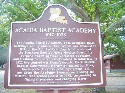
Acadia Baptist Acadamy Marker
| 1 ► Louisiana, Acadia Parish, Richard — Acadia Baptist Acadamy — 1917-1973 — |
| On Academy Drive, on the right when traveling east. | |||
| 2 ► Louisiana, Allen Parish, Kinder — St. Paul Baptist Church — Moorehead Public School — |
| On Hickory Flat Road, 1.4 miles north of U.S. 165, on the left when traveling north. | |||
| 3 ► Louisiana, Ascension Parish, Donaldsonville — African American Life — |
| On Lessard Street at Williams Street, on the right when traveling north on Lessard Street. | |||
| 4 ► Louisiana, Ascension Parish, Donaldsonville — Central Agricultural School — |
| On Williams Street near Lessard Street. | |||
| 5 ► Louisiana, Assumption Parish, Belle Rose — Israel Baptist School / Formerly Baptist Church School — (1872-1942) — |
| On State Highway 308 at Freetown Rd., on the left when traveling south on State Highway 308. | |||
| 6 ► Louisiana, Avoyelles Parish, Evergreen — Evergreen — |
| On Main Street (State Highway 29) at College Street, on the right when traveling north on Main Street. | |||
| 7 ► Louisiana, Avoyelles Parish, Marksville — Holy Ghost Catholic School — |
| On East Mark Street west of South Preston Street, on the left when traveling west. | |||
| 8 ► Louisiana, Avoyelles Parish, Marksville — Marksville "Colored" School Site — |
| On Legion Drive at Denux Street, on the left on Legion Drive. | |||
| 9 ► Louisiana, Avoyelles Parish, Marksville — Presentation Academy — |
| On South Washington Street north of East Wadill Street, on the right when traveling north. | |||
| 10 ► Louisiana, Beauregard Parish, DeRidder — Sam Houston Jones — Governor of Louisiana — 1940 - 1944 — |
| On South Washington Street south of Ronald Reagan Highway (U.S. 190), on the left when traveling south. | |||
| 11 ► Louisiana, Beauregard Parish, DeRidder — Shady Grove School/Community Building — |
| On State Highway 26 at Don Gray Road, on the right when traveling east on State Highway 26. | |||
| 12 ► Louisiana, Bossier Parish, Benton — Hughes House — |
| On Bossier Street at Bellevue Street, on the right when traveling south on Bossier Street. | |||
| 13 ► Louisiana, Caddo Parish, Belcher — Belcher High School — 1921 - 1968 — |
| On Gray Street (Louisiana Route 3049) north of Olympia Road, on the right when traveling north. | |||
| 14 ► Louisiana, Caddo Parish, Sentell — Cash Point School — A Rosenwald School — Historic Site — |
| On Dixie Shreveport Road (Louisiana Route 3049) 0.5 miles north of Whitefield Circle, on the right when traveling north. | |||
| 15 ► Louisiana, Caddo Parish, Shreveport, Allendale-Lakeside — Central School — Historic Site — Shreveport — |
| On Weinstock Street west of Pierre Avenue, on the left when traveling west. | |||
| 16 ► Louisiana, Caddo Parish, Shreveport, Broadmoor — A.C. Steere School — Historic Site — Shreveport — |
| On Youree Drive (State Highway 1) at Ockley Drive on Youree Drive. | |||
| 17 ► Louisiana, Caddo Parish, Shreveport, Caddo Heights — C.E. Byrd High School — Historic Site — Shreveport — |
| On Line Avenue south of Kings Highway, on the right when traveling north. | |||
| 18 ► Louisiana, Caddo Parish, Shreveport, Caddo Heights — 342 — Dodd College — |
| On Ockley Drive east of College Lane, on the right when traveling east. | |||
| 19 ► Louisiana, Caddo Parish, Shreveport, Caddo Heights — Dodd House — Historic Site — Shreveport — |
| On Ockley Drive at College Lane, on the right when traveling east on Ockley Drive. | |||
| 20 ► Louisiana, Caddo Parish, Shreveport, Downtown Riverfront — Chamber Plaza — Historic Site — Shreveport — |
| On Edwards Street south of Travis Street, on the left when traveling north. | |||
| 21 ► Louisiana, Caddo Parish, Shreveport, Downtown Riverfront — Chamber Plaza — |
| On Edwards Street north of Texas Avenue (U.S. 79/80), on the left when traveling north. | |||
| 22 ► Louisiana, Caddo Parish, Shreveport, Downtown Riverfront — Shreve Memorial Library — Historic Site — Shreveport — |
| On Texas Street (U.S. 79/80) at Marshall Street, on the right when traveling west on Texas Street. | |||
| 23 ► Louisiana, Caddo Parish, Shreveport, Highland — 184 — Centenary College of Louisiana — |
| On Sexton Street east of Centenary Boulevard, on the left when traveling east. | |||
| 24 ► Louisiana, Caddo Parish, Shreveport, Highland — Line Avenue School — Historic Site — Shreveport — |
| On Line Avenue near Wichita Street, on the right when traveling south. | |||
| 25 ► Louisiana, Caddo Parish, Shreveport, Highland — Pleasant Hall — Historic Site — Shreveport — |
| On Highland Avenue at Wyandotte Street, on the right when traveling north on Highland Avenue. | |||
| 26 ► Louisiana, Calcasieu Parish, Lake Charles — LaGrange High School — |
| On Ryan Street (State Highway 385) north of West School Street, on the left when traveling north. | |||
| 27 ► Louisiana, Calcasieu Parish, Lake Charles — St. Charles Academy — |
| On Ryan Street (State Highway 385) at Seventh Street/Dr. Michael Debakey Drive, on the right when traveling south on Ryan Street. | |||
| 28 ► Louisiana, Claiborne Parish, Arizona — Arizona Academy Site — |
| On Arizona Road (Louisiana Route 806) north of Tower Road, on the right when traveling south. | |||
| 29 ► Louisiana, Claiborne Parish, Haynesville — Carter G. Woodson High School — 1937 - 1970 — |
| On U.S. 79 at Hatter Street, on the left when traveling north on U.S. 79. | |||
| 30 ► Louisiana, Claiborne Parish, Homer — Homer College (CME) / African American Education in Louisiana — |
| On Lyons Hill Road, 1 mile north of Hill Farm Road, on the right when traveling north. | |||
| 31 ► Louisiana, Claiborne Parish, Homer — St. John Colored School — |
| On St. John Road (Parish Road 173) 0.1 miles north of Buster Johnson Road. | |||
| 32 ► Louisiana, Claiborne Parish, Homer — T. H. Harris — |
| On Louisiana Route 2 at Arizona Road on State Route 2. | |||
| 33 ► Louisiana, Claiborne Parish, Lisbon — Cane Ridge / James W. Nicholson — |
| On Louisiana Route 2 at Buck Green Road on State Route 2. | |||
| 34 ► Louisiana, East Baton Rouge Parish, Baton Rouge — Alvin Batiste — 1932-2007 — |
| On St Louis Street at North Boulevard, on the left when traveling north on St Louis Street. | |||
| 35 ► Louisiana, East Baton Rouge Parish, Baton Rouge — Joe Martin, Jr. — January 24, 1937 - October 17, 1998 — |
| On Airline Highway. | |||
| 36 ► Louisiana, East Baton Rouge Parish, Baton Rouge — 2/6 — John Archer Lejeune — Lieutenant General, U.S. Marine Corps — 1867-1942 — |
| Near South River Road west of Government Street (Louisiana Highway 73), on the right when traveling south. | |||
| 37 ► Louisiana, East Baton Rouge Parish, Baton Rouge — Original Site/Donors of Land — |
| On Chapelwood Drive south of Woodland Ridge Boulevard, on the right when traveling south. | |||
| 38 ► Louisiana, East Baton Rouge Parish, Baton Rouge — School For The Deaf — |
| On Mayflower Street at St Charles Street, on the right when traveling east on Mayflower Street. | |||
| 39 ► Louisiana, East Baton Rouge Parish, Baton Rouge — William Bartram Trail — Traced 1773-1777 — |
| Near Airline Highway (U.S. 61) 1 mile south of Highland Road (State Highway 42), on the right when traveling south. | |||
| 40 ► Louisiana, East Baton Rouge Parish, Baton Rouge, Downtown — Arsenal Museum — |
| On State Capitol Drive near North 5th Street, on the right when traveling east. | |||
| 41 ► Louisiana, East Baton Rouge Parish, Baton Rouge, Downtown — 10 — LSU Former Campus — |
| On Spanish Town Rd. near N. 4th Street, on the right when traveling east. | |||
| 42 ► Louisiana, East Baton Rouge Parish, Baton Rouge, Downtown — Ole War Skule — 1886 - 1925 — |
| On North 3rd Street south of State Capitol Drive, on the left when traveling south. | |||
| 43 ► Louisiana, East Baton Rouge Parish, Baton Rouge, Downtown — Pentagon Buildings — |
| Near North 3rd Street south of State Capitol Drive, on the right when traveling south. | |||
| 44 ► Louisiana, East Baton Rouge Parish, Baton Rouge, Downtown — St. Vincent's Academy/Catholic High School — |
| On North Street at North 4th Street, on the right when traveling west on North Street. | |||
| 45 ► Louisiana, East Baton Rouge Parish, Baton Rouge, Highlands/Perkins — 8 — Bagatelle Kitchen — c. 1840 — |
| Near Essen Lane (State Road 3064) south of Interstate 10, on the right when traveling south. | |||
| 46 ► Louisiana, East Baton Rouge Parish, Baton Rouge, Highlands/Perkins — Delta Zeta Sorority — |
| On West Lakeshore Drive, 0.1 miles east of South Campus Drive, on the right when traveling west. | |||
| 47 ► Louisiana, East Baton Rouge Parish, Baton Rouge, Highlands/Perkins — Distinguished Cadets — 1938-1939 — |
| On South Stadium Drive near South Campus Drive, on the right when traveling east. | |||
| 48 ► Louisiana, East Baton Rouge Parish, Baton Rouge, Highlands/Perkins — Distinguished Cadets — 1939-1940 — |
| On South Stadium Drive near South Campus Drive, on the right when traveling east. | |||
| 49 ► Louisiana, East Baton Rouge Parish, Baton Rouge, Highlands/Perkins — Distinguished Cadets — 1937-1938 — |
| On South Stadium Drive near South Campus Drive, on the right when traveling east. | |||
| 50 ► Louisiana, East Baton Rouge Parish, Baton Rouge, Highlands/Perkins — Distinguished Cadets — 1940-1941 — |
| On South Stadium Drive near South Campus Drive, on the right when traveling east. | |||
| 51 ► Louisiana, East Baton Rouge Parish, Baton Rouge, Highlands/Perkins — Ja'Marr Chase — Wide Receiver — |
| On West Stadium Dive north of South Stadium Drive, on the right when traveling north. | |||
| 52 ► Louisiana, East Baton Rouge Parish, Baton Rouge, Highlands/Perkins — Jerry Stovall — Halfback — All-American 1962 — |
| On West Stadium Drive north of South Stadium Drive, on the right when traveling north. | |||
| 53 ► Louisiana, East Baton Rouge Parish, Baton Rouge, Highlands/Perkins — La Maison Française & The Honors House — |
| On Highland Road at South Campus Drive, on the right when traveling east on Highland Road. | |||
| 54 ► Louisiana, East Baton Rouge Parish, Baton Rouge, Highlands/Perkins — Land Grant College / Sea Grant College — |
| On Tower Drive, 0.1 miles Dalrymple Drive, on the right when traveling south. | |||
| 55 ► Louisiana, East Baton Rouge Parish, Baton Rouge, Highlands/Perkins — Louisiana State Seminary of Learning Foundation Stone — |
| On Tower Drive, 0.1 miles south of Dalrymple Drive, on the right when traveling south. | |||
| 56 ► Louisiana, East Baton Rouge Parish, Baton Rouge, Highlands/Perkins — Louisiana State University & Surrounding Area — |
| On South Stadium Drive at East Parker Boulevard on South Stadium Drive. | |||
| 57 ► Louisiana, East Baton Rouge Parish, Baton Rouge, Highlands/Perkins — Louisiana State University and Agricultural and Mechanical College — |
| On Tower Drive, 0.1 miles south of Dalrymple Drive, on the right when traveling south. | |||
| 58 ► Louisiana, East Baton Rouge Parish, Baton Rouge, Highlands/Perkins — Manship School of Mass Communication — |
| On Fieldhouse Drive near North Stadium Drive, on the right when traveling east. | |||
| 59 ► Louisiana, East Baton Rouge Parish, Baton Rouge, Highlands/Perkins — Mike the Tiger - History — |
| On North Stadium Drive at West Stadium Road, on the right when traveling west on North Stadium Drive. | |||
| 60 ► Louisiana, East Baton Rouge Parish, Baton Rouge, Highlands/Perkins — Parade Ground — |
| On Dalrymple Drive west of Highland Road. | |||
| 61 ► Louisiana, East Baton Rouge Parish, Baton Rouge, Highlands/Perkins — Parade Ground — |
| On Veterans Drive near Highland Road, on the left when traveling east. | |||
| 62 ► Louisiana, East Baton Rouge Parish, Baton Rouge, Highlands/Perkins — Parade Ground — |
| On Highland Road south of Dalrymple Drive, on the right when traveling south. | |||
| 63 ► Louisiana, East Baton Rouge Parish, Baton Rouge, Highlands/Perkins — Parade Ground — |
| On Tower Drive south of Dalrymple Drive, on the right when traveling south. | |||
| 64 ► Louisiana, East Baton Rouge Parish, Baton Rouge, Highlands/Perkins — 24 — Schoolhouse — c. 1835 — |
| Near Essen Lane (State Road 3064) near 10, on the right when traveling south. | |||
| 65 ► Louisiana, East Baton Rouge Parish, Baton Rouge, Highlands/Perkins — 15 — Smokehouse — c. 1930 — |
| Near Essen Lane (Highway 3064) south of Interstate 10, on the right when traveling south. | |||
| 66 ► Louisiana, East Baton Rouge Parish, Baton Rouge, Highlands/Perkins — Sugar Kettle — |
| On Stadium Drive west of South Campus Drive, on the right when traveling west. | |||
| 67 ► Louisiana, East Baton Rouge Parish, Baton Rouge, Highlands/Perkins — Texas Bowl — December 29, 2015 — LSU 56, Texas Tech 27 — |
| On South Stadium Drive west of Fieldhouse Drive, on the right when traveling west. | |||
| 68 ► Louisiana, East Baton Rouge Parish, Baton Rouge, Highlands/Perkins — The Hill Memorial Library Columns — |
| Near Essen Lane (State Highway 3064) south of Interstate 10, on the right when traveling south. | |||
| 69 ► Louisiana, East Baton Rouge Parish, Baton Rouge, Highlands/Perkins — The Louisiana State University — |
| Near Tower Drive south of Dalrymple Drive, on the right when traveling south. | |||
| 70 ► Louisiana, East Baton Rouge Parish, Baton Rouge, Highlands/Perkins — Troy H. Middleton |
| Near Tower Drive south of Dalrymple Drive, on the left when traveling north. Reported permanently removed. | |||
| 71 ► Louisiana, East Baton Rouge Parish, Baton Rouge, Highlands/Perkins — 45 — Tyrone Slave Cabin — c.1840 — |
| Near Essen Lane (State Road 3064) south of Interstate 10, on the right when traveling south. | |||
| 72 ► Louisiana, East Baton Rouge Parish, Baton Rouge, Mid City South — Baton Rouge High School — Founded 1880 |
| On Government Street (State Highway 73) west of Odgen Drive, on the right when traveling west. Reported missing. | |||
| 73 ► Louisiana, East Baton Rouge Parish, Baton Rouge, Scotlandville — Dr. Julia Brogdon Purnell — Educator Humanitarian Leader — (1916-2013) — |
| On Leon Netterville Dr. south of Harding Boulevard, on the right when traveling north. | |||
| 74 ► Louisiana, East Baton Rouge Parish, Baton Rouge, Scotlandville — Pinckney Benton Stewart Pinchback — |
| On Leon Netterville Drive south of James J Prestage Street, on the right when traveling south. | |||
| 75 ► Louisiana, East Baton Rouge Parish, Baton Rouge, Scotlandville — Southern University — |
| On Leon Netterville Drive at James J Prestage Street, on the right when traveling south on Leon Netterville Drive. | |||
| 76 ► Louisiana, East Baton Rouge Parish, Baton Rouge, Scotlandville — Southern University — |
| On Scenic Highway (U.S. 61) near Harding Blvd. (Louisiana Highway 408), on the right when traveling south. | |||
| 77 ► Louisiana, East Baton Rouge Parish, Baton Rouge, South Baton Rouge — BREC's Bluebonnet Swamp Nature Center — |
| On North Oak Hills Parkway, 0.1 miles west of Bluebonnet Boulevard, on the right when traveling east. | |||
| 78 ► Louisiana, East Baton Rouge Parish, Pride — Pride High School — 1906-1981 — |
| On Port Hudson-Pride Road, 0.2 miles west of Liberty Road (State Road 409), on the right when traveling west. | |||
| 79 ► Louisiana, East Feliciana Parish, Jackson — Centenary College's Main Academic Building — |
| Near College Street near Pine Street, on the right when traveling north. | |||
| 80 ► Louisiana, East Feliciana Parish, Jackson — Centenary State Historic Site — "The East Wing Dormitory" — |
| Near College Street near Pine Street, on the right when traveling north. | |||
| 81 ► Louisiana, East Feliciana Parish, Jackson — Centenary State Historic Site — "The Professor's Cottage" — |
| Near College Street near Pine Street, on the right when traveling north. | |||
| 82 ► Louisiana, East Feliciana Parish, Jackson — Jackson — |
| On Charter Street (State Highway 10) east of Church Street, on the right when traveling east. | |||
| 83 ► Louisiana, Grant Parish, Colfax — Mary E. Graham High School — |
| On Graham Street west of Ash Street, on the right when traveling west. | |||
| 84 ► Louisiana, Grant Parish, Pollock — Pollock School — |
| On Howard Street (State Highway 8) west of Harvey Street, on the right when traveling east. | |||
| 85 ► Louisiana, Grant Parish, Prospect — Prospect School — |
| On Prospect Road near Prospect Church Road. | |||
| 86 ► Louisiana, Grant Parish, Verda — Verda — |
| On State Highway 1240 south of State Highway 122, on the left when traveling south. | |||
| 87 ► Louisiana, Iberia Parish, New Iberia — Booker T. Washington's Historic Visit to Howe Institute / Howe Institute — April 14, 1915 — 1888-1933 — |
| On Iberia Street west of East Washington Street, on the right when traveling west. | |||
| 88 ► Louisiana, Iberia Parish, New Iberia — Howe Institute — 1890-1933 — |
| On South Iberia Street west of East Washington Street, on the right when traveling west. | |||
| 89 ► Louisiana, Iberia Parish, New Iberia — Mt. Carmel Academy — |
| On Bridge Street, on the right when traveling west. | |||
| 90 ► Louisiana, Iberia Parish, New Iberia — Saint Peter's College — Circa 1918 — |
| On East Main Street (State Highway 182) near Civic Center Drive, on the right when traveling north. | |||
| 91 ► Louisiana, Iberville Parish, Dorseyville — St. John Baptist Church — |
| On Lacroix Rd at McMillian Drive, on the right when traveling north on Lacroix Rd. | |||
| 92 ► Louisiana, Iberville Parish, Plaquemine — Academy of Saint Basil — |
| On Court Street (State Highway 3066) at Church Street (Route 1), on the right when traveling west on Court Street. | |||
| 93 ► Louisiana, Iberville Parish, St. Gabriel — Bayou Paul Colored School — |
| On Bayou Paul Lane, 0.1 miles north of Bayou Paul Rd., on the right when traveling north. | |||
| 94 ► Louisiana, Jefferson Parish, Gretna — McDonoghville — |
| On Franklin Avenue (State Highway 23) at Virgil Street, in the median on Franklin Avenue. | |||
| 95 ► Louisiana, Jefferson Parish, Gretna — McDonoghville — |
| Near Brooklyn Avenue near Lawrence Street, on the right when traveling north. | |||
| 96 ► Louisiana, Jefferson Parish, Jefferson — Whitehall Plantation Home — |
| On River Road (State Road 611-1) at Central Avenue, on the right when traveling north on River Road. | |||
| 97 ► Louisiana, Jefferson Parish, Kenner — Kenner High School — 1924-1996 — |
| On Reverend Richard Wilson Drive (Route 48) at Duncan Street, on the right when traveling west on Reverend Richard Wilson Drive. | |||
| 98 ► Louisiana, Jefferson Parish, Kenner — Swans Club, Inc — |
| On Minor Street near 4th Street. | |||
| 99 ► Louisiana, Jefferson Parish, Metairie — Metairie Ridge School — |
| On Metairie Road (State Highway 611-9) east of Ellis Parkway, on the right when traveling east. | |||
| 100 ► Louisiana, Lafayette Parish, Broussard — St. Cecilia School — |
| On West Main Street, on the right when traveling west. | |||
231 entries matched your criteria. The first 100 are listed above. Next 100 ⊳