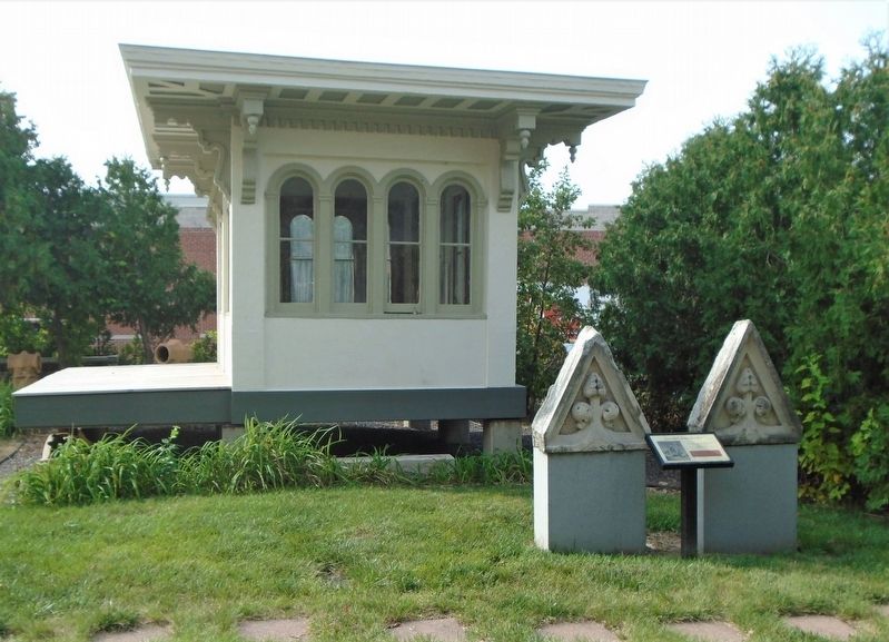
On 4th Street (Illinois Route 57) at Maine Street (U.S. 24), on the left when traveling north on 4th Street.
First United Presbyterian Church, 1879
8th & Broadway
Gothic Revival Style
Robert Bunce, Architect
Churches usually have an elaborate entrance or portico
to mark the transition into a religious dwelling.
The three portals symbolize the . . . — — Map (db m156776) HM
On South 12th Street north of State Street, on the right when traveling north.
This Greek Revival style mansion was built in 1835 by John Wood, Quincy's first settler, who erected a log cabin in 1822 at Front and Delaware Streets. The Society was formed in 1896, acquired the mansion in 1907, and maintains museum displays, loan . . . — — Map (db m187255) HM
Near Maine Street (U.S. 24) just west of 4th Street (Illinois Route 57), on the left when traveling west.
First United Presbyterian Church, 1879
8th & Broadway
Gothic Revival Style
Robert Bunce, Architect
The majority of churches built in Quincy in the 19th century revived a European Gothic style with pointed arches over the entrance and . . . — — Map (db m150586) HM
On 4th Street (Illinois Route 57) at Maine Street (U.S. 24) on 4th Street.
12th & Maine
Romanesque Revival Style
Harvey Chatten, Arthitect
———————————
Pilasters
Students entered the school through
a monumental arched entrance facing
on Maine . . . — — Map (db m156773) HM
On Hampshire Street east of 4th Street (Illinois Route 57), on the left when traveling east.
Type: Mediterranean Revival
Date: 1924
Architect: E. P. Rupert
Nominated by the Quincy Preservation Commission.
Approved by the Quincy City Council, January 3, 2000.
Charles W. Scholz, Mayor. — — Map (db m156777) HM
On Main Street at 3rd Street (Illinois Route 127), on the right when traveling west on Main Street.
This building used to be balanced by another more ornate one at the northern most part of the block. The old Post Office and the Cyclone Hose Company, Greenville's first Fire Station, were located in what was known as the Demoulin block before the . . . — — Map (db m34174) HM
On South State Street near East 2nd Street, on the right when traveling north.
This property is listed in the
National Register of Historic Places
by the
United States Department of the Interior
May 11, 2000
Beardstown Grand Opera House
c.1872
Heritage Preservation
Foundation
“Preserving our . . . — — Map (db m229612) HM
Nathan C. Ricker, the first person to graduate in architecture in the United States, established an architectural program here at his alma mater in 1873. Ricker emphasized the application of science and technology to design. He strove to create an . . . — — Map (db m225558) HM
On South Mathews Avenue at West Oregon Street, on the left when traveling south on South Mathews Avenue.
The Channing-Murray Foundation, originally established in 1908 as the Unitarian Church of Urbana, was placed on the National Register of Historic Places May 13, 1991 by the United States Department of the Interior. — — Map (db m225573) HM
On West Main Street (County Road 1600 N) at Race Street, on the right when traveling west on West Main Street.
The Cohen Building was designed by noted local architect Joseph W. Royer for prominent Urbana businessman and cigar manufacturer Nathan (Nat) H. Cohen. Other major downtown buildings designed by Joseph W. Royer include the Urbana Free Library, the . . . — — Map (db m226012) HM
On South Matthews Avenue at West Green Street, on the right when traveling south on South Matthews Avenue.
This facility originally known as the
Natural History Building
constructed in 1892
has been placed on the
National Register of Historic Places
by the United States
Department of the Interior — — Map (db m225572) HM
Near South Mathews Avenue south of West Oregon Street, on the right when traveling south.
This facility originally known as the
Astronomical Observatory
constructed in 1896
has been placed on the
National Register of Historic Places
by the United States
Department of the Interior — — Map (db m225534) HM
Near Lorado Taft Drive, 0.1 miles east of South 6th Street.
This facility originally known as the
Farm House
constructed in 1870
has been placed on the
National Register of Historic Places
by the United States
Department of the Interior — — Map (db m225529) HM
On West Green Street near South Birch Street, on the left when traveling west.
The need to repair or replace the original Universalist Church building, built in 1871 at the corner of Green and Birch Streets in Urbana, was discussed at the annual meeting of the Church Board on January 15, 1913. The Reverend E. V. Stevens . . . — — Map (db m226009) HM
Near Saint Marys Road at South Goodwin Avenue, on the left when traveling west.
This facility originally known as the
Barn #2
constructed in 1910
has been placed on the
National Register of Historic Places
by the United States
Department of the Interior — — Map (db m225581) HM
Near Saint Marys Road at South Goodwin Avenue, on the left when traveling west.
This facility originally known as the
Barn #3
constructed in 1912
has been placed on the
National Register of Historic Places
by the United States
Department of the Interior — — Map (db m225585) HM
Near Saint Marys Road at South Goodwin Avenue, on the left when traveling west.
These three round barns served as model dairy facilities for the University's
20-acre demonstration dairy farm developed in the early 20th century. The
farm's sole purpose was to produce the largest amount of milk per acre at the
lowest possible . . . — — Map (db m225577) HM
On Interstate 70, on the right when traveling west.
Hiram B. Trout and his brother, Everett Trout, were born on a farm about five miles north of this location. They operated a machine shop in Shelbyville, Illinois in the late 1800’s at which in time they invented and patented the unique design for . . . — — Map (db m59336) HM
On Jackson Street east of 6th Street, on the left when traveling east.
On December 25, 1830, the Illinois General Assembly created Coles County. At this time, Charleston became the county seat and was just a hamlet called "Coles Courthouse." In 1831, a log-cabin courthouse was constructed. About four years later, a . . . — — Map (db m188293) HM
On South Lincoln Highway, on the right when traveling east.
Members of Civilian Conservation Corps Co. V-2657 SP-52 built their barracks on this site in August 1935. The WWI veterans who comprised this CCC encampment named it Camp Shiloh after the burial place of Thomas and Sarah Lincoln. Like all CCC camps . . . — — Map (db m229793) HM
On West Euclid Avenue at Dunton on West Euclid Avenue.
Built in 1859 by Elijah Amasa Allen. In 1888 Eugene Berbecker, foster son of E.A. Allen Became Owner. Berbecker Park is named in his honor. — — Map (db m117510) HM
On Wisconsin Avenue south of 31st Street, on the left when traveling south.
The Arthur J. Dunham Centennial Home on the National Register of Historic Places. Built in 1906 in the Prairie School style, owned and lived in by the same family for over 100 years. — — Map (db m157107) HM
On Ogden Avenue west of South Lombard Avenue, on the right when traveling west.
(front:)
Route 66, the Mother Road, is an American icon that symbolizes romance and freedom of the open road. Born in 1926, Route 66 was one of the first numbered U.S. highways, journeying 2,500 miles from Chicago to Los Angeles. Today, . . . — — Map (db m159132) HM
This site was the former home of our Baboon Island exhibit. Opened in the mid-1930s, the exhibit, originally called Monkey Island, housed hundreds of different species throughout its tenure. This man-made mountain, a first of its kind in the U.S., . . . — — Map (db m231693) HM
On West Race Avenue at Menard Avenue, on the right when traveling west on West Race Avenue.
These four picturesque residences, designed by architect Frederick R. Schock, showcase the Queen Anne and Shingle styles of architecture. They helped set the tone for development of the Austin community in the 1880s-90s. — — Map (db m237403) HM
On Central Avenue, 0.1 miles north of Madison Street, on the right when traveling south.
Built four years after the suburb of Austin was annexed to Chicago, this house is among the best of Wright's experiments with inexpensive residences. Within a narrow lot, the house has
all the features of his mature Prairie style, characterized by . . . — — Map (db m235806) HM
On Belmont Avenue at Pulaski Road, on the left when traveling west on Belmont Avenue.
This building is a significant early 20th-century industrial building built for one of Chicago's best-known manufacturers. Founded and headquartered in the city for many years, the Florsheim Shoe Company was one of the nation's leading shoe . . . — — Map (db m94316) HM
Near South Indiana Avenue near East 33rd Boulevard.
Pilgrim Baptist Church
Adler and Sullivan, Architects
1891
The decorative and planning skills of Sullivan and the engineering ability of Adler are embodied in the strong masonry forms of this building, embellished with terra-cotta . . . — — Map (db m189477) HM
On South Martin Luther King Drive at East 35th Street on South Martin Luther King Drive.
Supreme Life Building
Built 1921; remodeled 1950
This was the longtime headquarters of the Supreme Life Insurance Co., the first African-American owned and operated insurance company in the northern United States. The firm was founded in . . . — — Map (db m188528) HM
On South Martin Luther King Jr. Drive at East 35th Street, in the median on South Martin Luther King Jr. Drive.
Chicago’s Boulevards are one of the city’s most overlooked treasures, and one of the largest and oldest boulevard systems in the nation. The 28-mile system contains 540 acres of green space, and provides a link between seven inland parks and . . . — — Map (db m189232) HM
On North Central Park Avenue north of Lake Street, on the right when traveling south.
Originally known as Central Park, Garfield Park was conceived as the centerpiece of the West Park System in 1869, and was renamed after President James Garfield's assassination in 1881. Plans for the entire ensemble of Humboldt, Garfield, Douglas . . . — — Map (db m241108) HM
On Central Park Avenue at Lake Street on Central Park Avenue.
In 1871, William Le Baron Jenney (best known for his innovations in skyscraper technology) created a master plan for the city's West Park District, consisting of three parks and connecting boulevards. In what would later become Garfield Park, he . . . — — Map (db m241133) HM
On South Hamlin Boulevard at West Madison Street, on the right when traveling north on South Hamlin Boulevard.
Originally known as Central Park, Garfield Park was conceived as the centerpiece of the West Park System in 1869, and was renamed after President James Garfield's assassination in 1881. Plans for the entire ensemble of Humboldt, Garfield, Douglas . . . — — Map (db m243680) HM
On North Hamlin Avenue south of West Lake Street, on the right when traveling north.
Originally known as Central Park, Garfield Park was conceived as the centerpiece of the West Park System in 1869, and was renamed after President James Garfield's assassination in 1881. Plans for the entire ensemble of Humboldt, Garfield, Douglas . . . — — Map (db m243684) HM
On West Congress Parkway at Independence Boulevard, on the right when traveling west on West Congress Parkway.
In 1871, William Le Baron Jenney (best known for his innovations in skyscraper technology) created a master plan for the city's West Park District, consisting of three parks and connecting boulevards. In what would later become Garfield Park, he . . . — — Map (db m244569) HM
On South Central Park Boulevard at West Jackson Boulevard on South Central Park Boulevard.
Originally known as Central Park, Garfield Park was conceived as the centerpiece of the West Park System in 1869, and was renamed after President James Garfield's assassination in 1881. Plans for the entire ensemble of Humboldt, Garfield, Douglas . . . — — Map (db m244575) HM
On West Madison Street at Homan Avenue, on the right when traveling west on West Madison Street.
Originally known as Central Park, Garfield Park was conceived as the centerpiece of the West Park System in 1869, and was renamed after President James Garfield's assassination in 1881. Plans for the entire ensemble of Humboldt, Garfield, Douglas . . . — — Map (db m244582) HM
On South Central Park Boulevard near Madison Street, on the right when traveling north.
Originally known as Central Park, Garfield Park was conceived as the centerpiece of the West Park System in 1869, and was renamed after President James Garfield's assassination in 1881. Plans for the entire ensemble of Humboldt, Garfield, Douglas . . . — — Map (db m244584) HM
On West Lake Street west of North Homan Avenue, on the left when traveling west.
Originally known as Central Park, Garfield Park was conceived as the centerpiece of the West Park System in 1869, and was renamed after President James Garfield's assassination in 1881. Plans for the entire ensemble of Humboldt, Garfield, Douglas . . . — — Map (db m244586) HM
On North Central Park Avenue, 0.1 miles north of West Washington Boulevard, on the left when traveling north.
The Garfield Park Fieldhouse, constructed in 1928 as the West Park Commission administrative headquarters, is one of the most lavish buildings on Chicago's west side. Designed by architects Michaelsen & Rognstad this "Gold Dome Building" has a 23 . . . — — Map (db m243639) HM
On East Bellevue Place east of North State Street, on the left when traveling east.
Bryan Lathrop House
McKim, Mead and White, architects
1892
Drawing inspiration from the neo-classical styles of
the eighteenth century, Charles Follen McKim here
created a residence of great dignity and elegance.
The clarity and . . . — — Map (db m180726) HM
This rare Art Moderne-style design is also one of the city's best examples of pre-World War II modernism. Further distinguishing the building is its handcrafted ornamentation by prominent artist Edgar Miller. The 12 residential units front on a . . . — — Map (db m235355) HM
On North Astor Street at East Schiller Street, on the right when traveling north on North Astor Street.
has been designated a
National Historic Landmark
This home, designed in 1891 by Louis Sullivan and
Frank Lloyd Wright, is an important work in the
development of modern residential architecture
and possesses national significance . . . — — Map (db m188276) HM
John Wellborn Root
Architect
1850-1891
John Wellborn Root's architectural designs
helped to establish Chicago as the
birthplace of modern architecture.
After the Great Fire of 1871, Root came
here from New York City to . . . — — Map (db m188509) HM
On East Burton Place near Astor Street, on the right when traveling west.
Originally built in 1891 for Elinor "Cissy" Patterson by architect Stanford White and late enlarged and occupied by Cyrus H. McCormick. This landmark property is now individual condominium residences. — — Map (db m132002) HM
On North Dearborn Parkway north of Schiller Street.
Chester H. Walcott, architect
Bennett, Parsons & Frost
consulting architects
awarded
the Lake Shore Trust & Savings Bank's
Gold Medal
for the most beautiful remodeled building
by the jury of the Chicago chapter,
American Institute of . . . — — Map (db m242577) HM
On North Dearborn Street north of Goethe Street, on the right when traveling south.
Built to provide a safe, supportive, and economical residence for young women studying the arts, this was one of a number of structures designed for artists around the turn of the century, indicative of a growing appreciation for the arts in urban . . . — — Map (db m242449) HM
On Humboldt Boulevard near North Avenue when traveling south.
Chicago's West Park Commission had just been created when residents began requesting that a park be named in honor of Baron Friedrich Heinrich Alexander von Humboldt (1769-1859), a German scientist who popularized the notion of living with nature. . . . — — Map (db m234585) HM
On North Avenue near Humboldt Boulevard, on the right when traveling west.
Chicago’s Boulevards are one of the city’s most overlooked treasures, and one of the largest and oldest boulevard systems in the nation. The 28-mile system contains 540 acres of green space, and provides a link between seven inland parks and . . . — — Map (db m234583) HM
On South Greenwood Avenue at East 53rd Street, on the right when traveling south on South Greenwood Avenue.
Built in 1903, this city block of semi-attached row houses from 5200 to 5244 South Greenwood Avenue is considered the original professors’ row of the University of Chicago. Samuel Gross, developer, and Joseph Brompton, architect — — Map (db m187528) HM
On South Greenwood Avenue at East 53rd Street, on the right when traveling south on South Greenwood Avenue.
This group of 20 visually distinctive row houses
was built in 1903 by one of Chicago's most prolific
early developers, Samuel E. Gross. The fine detailing
and craftsmanship used for building entrances and
cornices reflect the influence of the . . . — — Map (db m188627) HM
Near 57th Drive near DuSable Lake Shore Drive (U.S. 41).
Originally built as the Palace of Fine Arts for the World's Columbian Exposition, this plaster-clad structure later became the first home of the Field Museum of Natural History. After the museum left in the 1920s, the decayed building was . . . — — Map (db m238465) HM
On Science Drive at South Lake Shore Drive, on the right when traveling north on Science Drive.
The Norway Building stood on this site for the 1893 World's Columbian Exhibition. After the Fair Chicago millionaire C.K. Billings purchased the structure and moved it to his estate in Lake Geneva, Wisconsin. William Wrigley of chewing gum fame . . . — — Map (db m125028) HM
On South Ellis Avenue at East 49th Street on South Ellis Avenue.
Once referred to as the "Lake Forest of the South,"
this residential suburb was annexed to Chicago in 1889.
It was home to many of the city's leading industrialists,
who built residences designed by such notable architects
as George Maher, . . . — — Map (db m188828) HM
On South Greenwood Avenue near East 46th Street, on the right when traveling south.
Kenwood United Church of Christ
William. W. Boyington and Henry B. Wheelock,
architects
1887-88
This Richardsonian Romanesque-style church building is
a textbook example of this medieval-influenced style, popular in
the late nineteenth . . . — — Map (db m188566) HM
On South Lake Park Avenue at East 46th Street, on the right when traveling north on South Lake Park Avenue.
Louis Henry Sullivan
Architect
1856 - 1924
Known as the “prophet of modern architecture,”
Louis Sullivan advocated creating buildings that
honestly mirrored their time, place and technology.
Unlike many architects of the period . . . — — Map (db m188759) HM
On North Lincoln Boulevard near North Marshfield Avenue.
This terra-cotta-clad flat-iron building makes the most of its triangular building lot. Like many neighborhood banks from the 1920s, the Marshfield Trust and Savings Bank employed the Classical Revival style of architecture to convey a sense of . . . — — Map (db m208809) HM
Near North Recreation Drive near West Addison Drive, on the right when traveling north.
Originally known as the Lincoln Park Fieldhouse and Carillon Tower, the Waveland Clock Tower was constructed in 1931. The English Gothic style building was designed by Edwin H. Clark and the chimes were from the Deagan Company of Chicago. . . . — — Map (db m155667) HM
On North Pine Grove Avenue at West Diversey Parkway, on the right when traveling south on North Pine Grove Avenue.
Brewster Apartments
Enoch H. Turnock, architect
1893
The principles of skeleton-frame construction
that made possible tall commercial buildings
were used here for an early highrise apartment
building, originally known as the . . . — — Map (db m187901) HM
On West Fullerton Parkway at North Cannon Drive, on the right when traveling east on West Fullerton Parkway.
One of the most important historic landscapes in Chicago, this “hidden garden” in Lincoln Park was designed by note landscape architect Alfred Caldwell in the Prairie style. Inspired by his mentor Jens Jensen and the work of architect . . . — — Map (db m47845) HM
Near North Stockton Drive, 0.1 miles south of West Dickens Drive.
Along with the South Pond and Lincoln Park Zoo, the landmark buildings of Café Brauer and Carlson Cottage have served Chicago for more than 100 years. Their history parallels the growth of the pond—and the city around it.
Timeless . . . — — Map (db m47818) HM
Located in one of the country's oldest municipal zoological parks, the Lion House blends both the grandly-scaled public architecture of the Classical style with the innovative Prarie style developed by Chicago architects in the early 20th century. . . . — — Map (db m10653) HM
On North Sedgwick Street at North Clark Street, on the right when traveling south on North Sedgwick Street.
This area, with its concentration of brick row houses,
is typical of urban residential communities developed
during the last three decades of the nineteenth
century. The high quality of its architecture, well-
preserved and well-maintained, . . . — — Map (db m185766) HM
On North Clark Street south of West Wrightwood Avenue, on the left when traveling south.
North Chicago Hospital Building
Meyer J. Sturm, architect;
M. Louis Kroman, associated architect
1928-29
This building is a handsome example of a neighborhood hospital
building, built when Chicago was dotted with small . . . — — Map (db m180732) HM
On Ravenswood Avenue at Rosehill Drive, on the left when traveling north on Ravenswood Avenue.
Designed by the architect of the Old Chicago Water Tower and predating it by five years, the Rosehill Cemetery Entrance is a rare Midwestern example of castellated Gothic architecture. Many prominent Chicagoans are buried here in plots marked by . . . — — Map (db m94331) HM
On West Cortland Street at North Humboldt Boulevard, on the right when traveling west on West Cortland Street.
Featuring streetscapes of handsome mansions, apartment buildings, and institutional and commercial buildings from the 1880s through the 1930s, the District is one of the best-preserved portions of Chicago's extensive park boulevards system. — — Map (db m234590) HM
On West Shakespeare Avenue at North Humboldt Avenue on West Shakespeare Avenue.
Featuring streetscapes of handsome mansions, apartment buildings, and institutional and commercial buildings from the 1880s through the 1930s, the District is one of the best-preserved portions of Chicago's extensive park boulevards system. — — Map (db m234591) HM
On West Armitage Avenue at North Humboldt Boulevard, on the left when traveling east on West Armitage Avenue.
Featuring streetscapes of handsome mansions, apartment buildings, and institutional and commercial buildings from the 1880s through the 1930s, the District is one of the best-preserved portions of Chicago's extensive park boulevards system. — — Map (db m234592) HM
On West Palmer Square at North Whipple Street on West Palmer Square.
Featuring streetscapes of handsome mansions, apartment buildings, and institutional and commercial buildings from the 1880s through the 1930s, the District is one of the best-preserved portions of Chicago's extensive park boulevards system. — — Map (db m234593) HM
On West Palmer Street near North Humboldt Boulevard, on the right when traveling east.
Featuring streetscapes of handsome mansions, apartment buildings, and institutional and commercial buildings from the 1880s through the 1930s, the District is one of the best-preserved portions of Chicago's extensive park boulevards system. — — Map (db m234594) HM
On North Milwaukee Avenue at West Logan Boulevard, on the left when traveling north on North Milwaukee Avenue.
Chicago’s Boulevards are one of the city’s most overlooked treasures, and one of the largest and oldest boulevard systems in the nation. The 28-mile system contains 540 acres of green space, and provides a link between seven inland parks and . . . — — Map (db m110744) HM
On Madison Street at State Street, on the left when traveling west on Madison Street.
This building epitomizes the Chicago School, a design movement that changed modern architecture. Its distinctive features include large windows, steel-frame construction, projecting bays, and ornate terra cotta cladding. Located at what was known as . . . — — Map (db m240284) HM
This building is an exceptional example of the International Style and was Chicago's first major public building to be designed in a modern, rather than historically-derived, style. Innovative for its time are the building's eight-seven foot spans . . . — — Map (db m242108) HM
Near South Michigan Avenue north of East Ida B. Wells Drive, on the right when traveling south.
Built by the Studebaker company for the assembly and display of their carriages and wagons, this building was converted into studios and theaters for artists and craftsmen in 1898. The interior public spaces, featuring murals on the tenth floor, . . . — — Map (db m237986) HM
461 entries matched your criteria. The first 100 are listed above. Next 100 ⊳