Abraham Curry, the “Father of Carson City”, accomplished more in his 15 year residence than most men hope to in a lifetime. Not only did he purchase the land in 1858 which is now Carson City, but laid out the townsite and built many of . . . — — Map (db m20874) HM
In 1902 Marion Jefferson Blackwell purchased 360 acres from the State of Nevada, 556 acres of adjoining land from Sweeney’s Hot Springs and a lot with a house. He raised carp and catfish to sell commercially also hay and horses. Neighbors used the . . . — — Map (db m116178) HM
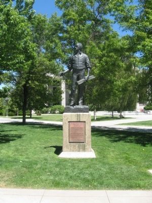
[Front of Marker:]
Dedicated April 12, 1996
Carson City
Original Station
Apr. 3, 1860 - Nov. 20, 1861
by
Byron L. & Peggy Clark & Family
Bob & Tina McFadden
Mae & Jim Thorpe
The Bike Smith
Betty Young & Erica . . . — — Map (db m23038) HM
This is the site of the house and observatory of Nevada’s first weatherman, astronomer, and seismologist, Charles William Friend. Born in Prussia in 1835, Friend immigrated by way of South America to California during the 1849 Gold Rush. In 1867, he . . . — — Map (db m162166) HM
This site was part of Carson City's Chinatown, which at one time was one of Nevada's largest Chinese Communities. In the 1880 Census Manuscript of Carson City, of the 789 Chinese, 706 were men and of these, 267 were married, 18 were widowed, 391 . . . — — Map (db m146930) HM
When the Comstock Lode was discovered in 1859, the problem of reducing the ore from the fabulously rich Virginia City mines had to be solved. Mills were built in Gold Canyon and Six Mile Canyon. In Washoe Valley, at Dayton, and on the Carson River . . . — — Map (db m55083) HM
On this site in the period from 1870 until 1918 stood the ornate two-story home of Mathew Culbertson Gardner, rancher and lumberman. The residence was headquarters for Gardner’s 300 acre ranch in Meadows to the Southward.
Here was located, 1870 . . . — — Map (db m20926) HM
Approximately one-half mile south of this point and west of the present highway lay the immense lumberyard of the Carson-Tahoe Lumber and Fluming Company, the greatest of the Comstock lumbering combines operating in the Lake Tahoe Basin during . . . — — Map (db m20804) HM
In March 1868 William Sharon of the Bank of California contracted with Isaac Evan James to construct a railroad from the mines of the Comstock Lode to the stamp mills located on the Carson River. Survey work got underway in December and grading . . . — — Map (db m21338) HM
As early as 1863, two hotels with appurtenant stables were located here. In 1872, one hotel became a station on the newly-completed Virginia and Truckee Railroad between Carson City and Reno.
Crossing under the highway are three inverted . . . — — Map (db m244508) HM
Logging wagon built in 1870 at Bassett Station, Yuba Pass. Used to haul lumber to the Sierra Buttes mines with teams of oxen. Presented to Nevada Day committee in 1950 by Ceasar P. Lombardi. — — Map (db m163897) HM
Completed in 1876, this palatial residence represents one of the finest and best preserved examples of High Victorian Italianate architecture remaining in the American West.
Charles H. Jones, a French-schooled designer, constructed the residence . . . — — Map (db m21246) HM
One of the oldest continuously operating hotels in the state. It is composed of two hotels. The three story St. Charles and the two story Muller House next door south. Construction of both buildings took place in 1862 with completion in August of . . . — — Map (db m23039) HM
The original Carson City building is a formal balanced, sandstone block edifice, two stories high with a centrally located, cupola. The sandstone blocks were quarried at the Nevada State prison. On March 3, 1862, Congress passed a bill establishing . . . — — Map (db m89543) HM
The original Carson City building is a formal balanced, sandstone block edifice, two stories high with a centrally located, cupola. The sandstone blocks were quarried at the Nevada State prison. On March 3, 1862, Congress passed a bill . . . — — Map (db m89438) HM
Adolph Sutro engineered and constructed the Sutro Tunnel. Approximately four miles long, the Tunnel runs in a westerly direction intersecting the Comstock Lode some 1600 feet under Virginia City. The portal is near Dayton, Nevada. The Tunnel . . . — — Map (db m146900) HM
The quarried sandstone you are looking at came from
the Virginia and Truckee Railroad's machine shop and engine
house also referred to as "the Stone Fort” or
the Carson City/Virginia and Truckee Roundhouse.
The Stone was quarried at the . . . — — Map (db m157591) HM
Fairview was part of the renewed interest in mining. Triggered by the strikes in Tonopah and Goldfield. Discoveries in 1905 of a rich silver float led to a boom that lasted through 1906 and 1907. A substantial town that boasted 27 saloons, hotels, . . . — — Map (db m67147) HM
"The Mail Must Go Through"
From April 3, 1860 to November 21, 1861, mail was delivered by the Pony Express between St. Joseph, Missouri and Sacramento, California. It was a relay system between 190 stations along the route. A fresh horse was . . . — — Map (db m142572) HM
Want it known that in the State of Nevada....
This site is dedicated not for it’s historical significance, but for the significance of the genuine gold diggers of Western history... the working girls who made a man forget the back breaking work . . . — — Map (db m90814) HM
Sand Springs Deserved its Name The rocks you see in front of you were once Sand Springs Pony Express Station. The Pony Express ended in November 1861, but this Station was used as a stopover for freight wagons until the late 1800s. It laid . . . — — Map (db m142573) HM
Little known at the time, except as a stage stop, Williams Station was destined to be remembered in Nevada history as the incident that ignited the Pyramid Lake War of 1860.
Williams Station was named for three brothers, James O., Oscar, and . . . — — Map (db m168508) HM
The building of Hoover Dam was a ray of hope for a nation struggling
with hard times. Newsreel images of the high-scalers who worked the
canyon walls ignited public interest in the project.
"Scaling" is the process of removing loose rock . . . — — Map (db m111191) HM
Legend has it there are many workers buried in Hoover Dam. However, due to the manner in which the Dam was constructed, this would have been impossible. "Puddlers" directed buckets of concrete over empty forms, released the concrete, and then used . . . — — Map (db m39488) HM
The Hoover Dam construction crew’s mascot was found as a
puppy by workers at the construction camp. This dog traveled
to and from the dam site with them and spent his days visiting
the many work areas. On February 21, 1941, the life of this . . . — — Map (db m111203) HM
At the height of Hoover Dam construction, more than 7,000 men labored in Black Canyon. Some jobs were glamorous and exciting, such as the high scalers who swung over the canyon on ropes or the cableway operators who kept concrete buckets moving 24 . . . — — Map (db m39487) HM
Originally founded in 1931 as a community for the workers building Hoover Dam, Boulder City was the first planned community in southern Nevada. Designed by Saco Rienk DeBoer, it was a federal reservation. Only workers associated with the building or . . . — — Map (db m71903) HM
[ Front ]:
"The Old Man"
Francis Trenholm Crowe
Born: October 12, 1882
Died: February 26, 1946
World's Outstanding Builder of Dams
[ Right Side ]:
"We had 5,000 men in a 4000-foot canyon. The problem was to . . . — — Map (db m39485) HM
[ Front ]:
They endured the hardships so all of America might prosper
This Memorial was contributed by the men and women who built Hoover Dam to commemorate the 50th anniversary of its dedication
September 30, . . . — — Map (db m39486) HM
This cast steel turbine runner (water wheel), which is 14.2 feet in diameter and weighs over 34 tons, powered the N-7 generator at Hoover Dam Power Plant from 1944 to 1982. The function of a turbine runner is to convert the force of falling water, . . . — — Map (db m29248) HM
The Boulder Dam Hotel has been part of Boulder City history since its opening in 1933. Designed by Mort Wagner the hotel was built by Paul Stewart "Jim" Webb, Raymond Spilsbury, and Austin Clark. It is located in Cardenas Plaza - known today as . . . — — Map (db m39502) HM
George Fayle moved to southern Nevada from Calico, California in 1904. He settled at Goodsprings Junction, which was later renamed for his wife Jean. In 1912, he moved to Goodsprings. He built the Pioneer Saloon in 1913, later building the Fayle . . . — — Map (db m39472) HM
Seeking Pay Dirt
In 1908, mining engineer Robert T. Hill staked a claim in Railroad Pass hoping to find gold deposits as rich as those in Goldfield to the north and Searchlight to the south. Hill reasoned that gold could surely be found at . . . — — Map (db m46738) HM
The San Pedro, Salt Lake and Los Angeles Railroad bought Helen Stewart's Las Vegas Ranch in 1902, giving it control of the Las Vegas Springs and the water supply needed for the creation of Las Vegas in 1905. The railroad's subsidiary, the Las Vegas . . . — — Map (db m50274) HM
The Bow & Arrow Motel was originally installed in Downtown Las Vegas on Wyoming Avenue.
The Allied Arts Council donated the Bow & Arrow Motel sign to The Neon Museum in 2001. — — Map (db m145470) HM
This Jerry's Nugget cabinet rotated atop a vertical tower of letters spelling "Nugget", advertising the popular North Las Vegas local's casino. Circa 1970s, the sign incorporates skeleton neon and hand lettering for lively day and night . . . — — Map (db m92471) HM
Created in 1962 by architects Wayne McCallister and William Wagner and YESCO design staff. The three-story concave panel of interlocking neon "H" elements formed the corner bullnose for the casino's façade on Fremont Street. At the time, the . . . — — Map (db m92470) HM
Neon guitar signs became the symbol world-wide for the Hard Rock brand. This Las Vegas guitar sign is important because it was the flagship -- the first Hard Rock Café guitar in the world. It graced the corner of Paradise Road and Harmon Avenue . . . — — Map (db m145771) HM
Panel one: The Neon Boneyard Park Sign
The lettering on a neon sign is often the most memorable design component. The Neon Boneyard Park sign includes hidden reference to this aspect of the grand history of Las Vegas signage. Each letter in . . . — — Map (db m71210) HM
The notorious Block 16, North First Street between Ogden and Stewart Avenues, was the only area in the Las Vegas Townsite, outside of hotels, where liquor could be sold, starting in 1905. The block quickly changed from its original liquor and . . . — — Map (db m47859) HM
This is a two sided marker
Side A:
Standing on Fremont Street today, it's hard to visualize the canvas tents with hand-painted wooden signs that lined this dusty street and served as hotels, saloons, shops and banks in the early 1900's. . . . — — Map (db m47754) HM
Black entertainers were not allowed to stay at the Strip hotels where they performed in the 1940s and 1950s. Mrs. Harrison's boarding house offered fine accomodations for many of the era's most famous stars.
During one memorable week in . . . — — Map (db m51050) HM
Commerce on the Westside was short lived, collapsing in 1905 when rival Las Vegas Townsite opened on the east side of the railroad tracks. In 1942, the Westside defined a new commercial district to serve the ethnic population of the area.
The . . . — — Map (db m51051) HM
The Bureau of Indian Affairs (BIA) bought this ten-acre site in 1911 from Helen J. Stewart, former owner of the Las Vegas Ranch, to provide a home for the Southern Paiute Indians living in and near Las Vegas. With this purchase, the government . . . — — Map (db m51055) HM
Opened in 1937 at 5th Street (Las Vegas Boulevard) and Garces, the Nevada Motel was the first auto court in Las Vegas to identify itself as a "motel". In its last years in business it operated in conjunction with the Sweetheart Wedding Chapel next . . . — — Map (db m64028) HM
On this site stood "Old Betsy," Las Vegas' first electric generator, which serviced the power needs of the new town. The generator, operated by the Consolidated Power and Telephone company, supplied electricity from 1906-1916. The company evolved . . . — — Map (db m47867) HM
Charles "Pop" Squires, often referred to as "the Father of Las Vegas" lived at this location, with his wife, Delphine, from 1931 until his death 1958.
Squires first arrived in the Las Vegas Valley in February 1905. He and his partners . . . — — Map (db m131061) HM
The Silver Slipper was originally installed on the grounds of the Last Frontier on Las Vegas Boulevard.
The Slipper was designed by Jack Larsen and built by Young Electric Sign Company. — — Map (db m92469) HM
As a founder of one of the pioneer families of Las Vegas, Ed Von Tobel came to the 1905 Las Vegas land auction and purchased a lot. He established a lumber company on Main Street in 1905 and then moved to this site in 1906. The hardware business . . . — — Map (db m47879) HM
Opened around 1931 by Mrs. Mattie "Jimmy" Jones, the Green Shack restaurant was a town landmark at this site. The restaurant opened in a Union Pacific Railroad barracks building that was moved here; in 1934 additions were made to the structure. For . . . — — Map (db m47894) HM
The Wengert residence was originally owned by Cyril S. and Lottie Wengert. Built in 1938, this Tudor Revival home was designed by Architect, H. Clifford Nordstrom, and was amongst the largest in Las Vegas. Prominent in Las Vegas social and business . . . — — Map (db m114796) HM
Spanish Trail routes crossed deserts and mountain ranges far from Mexican settlements and government authorities. Horses and mules were in short supply to conduct the Santa Fe-Missouri trade opened in 1821 by Americans from Missouri. Outlaws and . . . — — Map (db m241725) HM
By 1855 wagon roads linked Utah to California. To ease the long trip between Los Angeles and Salt Lake City, the LDS church established an outpost at an oasis called, Las Vegas, along the Old Spanish Trail/Mormon Road.
Thirty missionaries . . . — — Map (db m241723) HM
After the United States government's successful experiment with camels in the west in 1857, entrepreneurs saw possibilities in the ungainly beasts for carrying supplies. In addition to the government's camels, which were sold off by 1864, two . . . — — Map (db m78520) HM
During the building of Davis Dam, the Nevada side of the river here became known as Tristate. In 1964, Don Laughlin was looking for an investment opportunity. He had sold his 101 Club in North Las Vegas, and flew over a closed saloon and motel . . . — — Map (db m46732) HM
On this site was one of the first rest-over businesses in the Virgin Valley. Here an early version of an adobe brick house was used as a small grocery store with a separate wash house that had shower and laundry facilities, and a way station . . . — — Map (db m46745) HM
Abram Woodbury, one of the first permanent settlers in Mesquite, built a new home here circa 1919 and opened a mercantile store. He also built overnight cabins for tourists and operated Mesquite's first gas station. Abram purchased gasoline by the . . . — — Map (db m46762) HM
In the 1940's the place to go was Leonard Patty's soda fountain and drug store. This was the first soda fountain in town and served up all the favorites for quenching thirst in those days, including phosphates and sodas of all varieties – . . . — — Map (db m46763) HM
The Egg Association formed circa 1929 as a local cooperative, selling and distributing local eggs to tourist oriented businesses, or to market in Las Vegas. High school boys studying agriculture were part of the enterprise. The Association built a . . . — — Map (db m46746) HM
This adobe brick building was built by Deloy Abbott circa 1932. Behind the house was another adobe building used as a chicken coop. Ervin Jones purchased the home in 1941 and lived here until his death. The house was later converted to a business. — — Map (db m46741) HM
Tithing Lot
Circa Late 1890s.
The southeast quarter of this block was originally owned by the Church of Jesus Christ of Latter Day Saints and was used as a tithing lot. Church members paid tithing in-kind donations of fruit, crops, etc., . . . — — Map (db m1282) HM
This is a two-story adobe building with a rock foundation. The walls are three adobes thick and there are six rooms on each floor. Abbott served as Bishop of the local congregation of the Church of Jesus Christ of Later-day Saints for 27 years. His . . . — — Map (db m46740) HM
About 1922, J. H. Nicolaides overheard two state highway engineers talking about the new route Arrowhead Trail Highway would take in southern Nevada. Realizing a service station would be necessary at the crossing the road would make over the Muddy . . . — — Map (db m114821) HM
Toward the Colorado River from this point runs El Dorado Canyon where occurred one of the biggest mining booms in Nevada history. Gold and Silver mines were developed here about 1859 and soon rich mines were developed. In the 1860's the canyon . . . — — Map (db m29326) HM
Toward the Colorado River from this point runs El Dorado Canyon where occurred one of the biggest mining booms in Nevada history. Gold and Silver mines were developed here about 1859 and soon rich mines were developed. In the 1860's the canyon . . . — — Map (db m29327) HM
Eldorado Canyon, the site of a mining boom, runs east from here to the Colorado River. Prospectors began digging for gold and silver here, about 1859, forming the Colorado Mining District. The three largest mines, the Techatticup, Wall Street, and . . . — — Map (db m92463) HM
The Techatticup Mine, located in 1861, was the most important mine in El Dorado Canyon. It produced millions of dollars in gold ore, and was originally served by steamboats on the Colorado River. The mine's name is taken from two Paiute words . . . — — Map (db m29331) HM
Established by Conrad Kiel in 1875, this was one of the only two major ranches in Las Vegas Valley throughout the 19th century. The Kiel tenure was marked by violence. Neighboring rancher Archibald Stewart was killed in a gunfight here in 1884. . . . — — Map (db m22414) HM
This ruin appears to be a symbol of ancient times but was actually built in 1965 for the movie "The Professional." The main movie set, a Mexican hacienda, was located where the parking lot is now. Railroad ties can still be seen sticking out of the . . . — — Map (db m72358) HM
The Red Barn opened in 1958 as an antique store near Tropicana Avenue and Maryland Parkway. In 1961 the store was converted into a club that was the first coffeehouse in Las Vegas and a popular hangout among local college students. The Red Barn . . . — — Map (db m112138) HM
George Frederick Colton can be considered to be the father of Searchlight. The Searchlight claim made on May 6, 1897 was the earliest claim of importance in what became the Searchlight Mining District. He is also credited with providing the name of . . . — — Map (db m29333) HM
Initial discoveries of predominately gold ore were first made at this location on May 6, 1897. G. F. Colton filed the first claim, later to become the Duplex Mine. The Quartette Mining Company, formed in 1900, became the mainstay of the . . . — — Map (db m29369) HM
Panel One: the lifestyle was rustic here at the summit
In 1860, French-Canadian entrepreneur Michele E. Spooner acquired about 640 acres of land with the idea of starting up a sawmill, a shingle mill and a hotel. He named the area . . . — — Map (db m227674) HM
Originally the site of the I.O.O.F. hall built by Baptiste Borda at the turn of the 19th Century. The Adaven Building has been a merchandise store, soda fountain, restaurant, and hotel. The Adaven Building also had a post office for a period of . . . — — Map (db m21649) HM
The Arendt Jensen, Jr. House is a 1-1/2 story bungalow style home and stands near the Arendt Jensen Mansion, the first and largest home built by the Jensen Family.
Completed in 1932, the home was built for Arendt Jensen, Jr. and his wife Minnie . . . — — Map (db m21682) HM
Vernacular with neoclassical elements style
Arendt Jensen built this general merchandise store in the early 1900's. On the store shelves shoppers could find a wide variety of everyday necessities and supplies from clothing to agricultural . . . — — Map (db m21466) HM
The East Fork Hotel was constructed in 1893 by George and Charley Brown, two brothers who came to Genoa, Nevada with a traveling circus. The Brown Brothers also owned the East Fork Brickyard, providing bricks that were used in many Valley . . . — — Map (db m24832) HM
This building dates back to the 1870's and was moved to Carson Valley from Virginia City before the end of the 19th Century. It was somewhat commonplace to move buildings from Virginia City after the Comstock Lode Era.
Town founder Lawrence . . . — — Map (db m24091) HM
Arendt Jensen had this beautiful mansion constructed for his family in 1910. Mr. Jensen owned a general store in Gardnerville that became very prosperous. He later established the first bank in the Carson Valley, the Douglas County Farmer's Bank. . . . — — Map (db m21541) HM
The Jensen Family emigrated from Denmark in the late Nineteenth Century. As Gardnerville grew, Arendt Jensen, Sr. took advantage of the growing economy becoming a successful businessman and banker.
The Jensen Family's merchandise store was . . . — — Map (db m21721) HM
This building has been used for many commercial purposes dating back to the late 1800's and early 1900's. The single story rear portion of the building is thought to be the original home of John and Mary Gardner, the Town's namesake. Ollie . . . — — Map (db m21617) HM
The Record Courier has been published in Douglas County since 1904 when Dr. Southworth merged the Gardnerville Record and the Genoa Weekly Courier into one newspaper. In 2004 the Record Courier marks a solid century of printing.
This building . . . — — Map (db m28071) HM
Opened in 1896 by Mr. and Mrs. William Ritchford, the three-story hotel was a stage stop. A water tower was also built on the site, however it no longer stands.
The Ritchford was the most luxurious hotel in town at the turn of the century. It . . . — — Map (db m25577) HM
The "Corner Saloon" was constructed on this site in the late 1890's. Adjacent uses on and near this site came to include a drug store, blacksmith shop, and mortuary. C.M. Krummes operated the blacksmith shop and mortuary, and served as the first . . . — — Map (db m21446) HM
This building served as the first Catholic Church in Gardnerville, and is an excellent representation of brickwork found in many valley buildings.
Completed in 1919 on land donated by local merchant Sam Imelli, the building was used until . . . — — Map (db m23250) HM
One of the original businesses in Gardnerville, the East Fork Hotel once stood proudly on Main Street at Gilman Ave. In 1892-93, Brothers George and Charles Brown built a 20' x 50' building with a saloon in front and a small residence in the back . . . — — Map (db m236760) HM
Owned at one time by Baptiste Borda and later leased to the Mitcheo family. Raymond Borda, upon returning from World War II, owned and operated the hotel for many years. The French Hotel was one of the three main Basque hotels in Gardnerville . . . — — Map (db m25321) HM
An important hostelry was so named because of its distance from Genoa and also from Cradlebaugh Bridge across the Carson River. It was built in 1860 by Thomas Wheeler, where the Boyd Toll Road to Genoa and the Cradlebaugh Toll Road to Carson City . . . — — Map (db m89436) HM
By 1900 the town of Gardnerville had replaced Genoa as Carson Valley's commerce center. Hotels, stores, and liveries in Genoa closed, and buildings stood vacant. One Genoa couple saw a shuttered hotel as the key to a better life for their . . . — — Map (db m227670) HM
In early June, 1850, a party of Mormons led by Abner and Thomas Blackburn, Hampton S. Beatie and Joseph Dumont, established a trading post about a mile to the north of this site. In September, as they returned to Salt Lake City, a party of Bannock . . . — — Map (db m20698) HM
In 1863, Al Livingston built this building and called it Livingston’s Exchange. In 1884, Frank Fettic bought it and renamed it Fettic’s Exchange. He operated it as a “Gentlman's Saloon” allowing no rough stuff or excessive drinking. It subsequently . . . — — Map (db m20661) HM
The principle emigrant trail to California’s gold fields in the 1850’s passed about 50 yards east of here. In June, 1850, Hampton S. Beatie and Abner Blackburn, two Mormons from Salt Lake City, established Nevada’s first trading post a few yards . . . — — Map (db m21218) HM
Here stood the first grist mill in Carson Valley built in Mill Canyon Genoa in 1854 by wheelwright Thomas Knott for Colonel John Reese. It was moved to this site by William M. Cary in 1865.
Behind the mill stood a dwelling house, which served . . . — — Map (db m99863) HM
In 1877, John H Davis had this building constructed as a new location for his existing store nearby. The general store was an integral part of 1800s era towns like Genoa and supplied dried goods, food and other necessities to the growing Nevada . . . — — Map (db m169673) HM
These plaques are near the site
of the original Pony Express Station.
The Pony Express passed through
Genoa, the oldest city in Nevada, until
the completion of the telegraph.
Erected by the Nevada Pony
Express Centennial Committee. . . . — — Map (db m20711) HM
298 entries matched your criteria. The first 100 are listed above. Next 100 ⊳