Near Nature Center Drive south of Stratford Drive, on the right when traveling south.
Originally built in the 1870s for Austin pioneer Ashford McGill, this native limestone structure and the surrounding property were purchased by Andrew J. Zilker who conveyed the land to the city for a park in 1931. Remodeled by the Federal Civil . . . — — Map (db m25701) HM
Near West Cesar Chavez Street north of Stephen F Austin Drive, on the left when traveling north.
Tax supported, locally controlled secondary education began in Austin in 1881 with the establishment of a high school department in the city school district. Plans for implementing the program were developed under the leadership of school board . . . — — Map (db m25705) HM
On Sprinkle Road at Springdale Road, on the right when traveling east on Sprinkle Road.
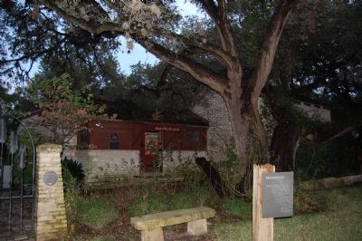
Built in 1898 for cotton merchant William Braxton Barr (1864-1902) and his wife, Matilda (Tilly) Birdwell (1868-1951), this home was designed by Austin architect Charles Page. Barr named the surrounding community after his grandfather Capt. . . . — — Map (db m25740) HM
On Veterans Drive east of Atlanta Street, on the right when traveling east.
Named in honor of William Barret Travis. Born in Edgefield District, South Carolina, August 1, 1809. Came to Texas in 1831. Commander at the Alamo where he was killed March 6, 1836.
Austin, the county seat, selected as the Capital of the . . . — — Map (db m26686) HM
On Vine Street north of Cavileer Avenue, on the right when traveling north.
George W. Davis (ca. 1809-1884), his wife Emiline P. Moore Davis (1810-1872) and family arrived in Texas in 1835. George served in Captain Mosely Baker’s company at the Battle of San Jacinto while Emiline spent six weeks with the children on the . . . — — Map (db m26778) HM
Near William Barton Drive west of Andrew Zilker Road, on the left when traveling west.
Voted Austin's most worthy citizen twice, Indiana native Andrew Jackson Zilker (1858-1934) grew up with a strong respect for the laborers along the Ohio River. He came to Austin penniless in 1876 but quickly became a businessman and bank director. . . . — — Map (db m25697) HM
Near Navasota Street north of East 7th Street, on the right when traveling north.
A signer of the Texas Declaration of Independence.
Secretary of the Treasury of the Republic.
Born in Tennessee, 1795. Died on Caney Creek, Matagorda County October 12, 1836 — — Map (db m25688) HM
Near Navasota Street north of East 7th Street, on the right when traveling north.
Here sleep Capt. and Mrs. Chauncey Johnson. Capt. Johnson was born in Burlington, Vermont May 1, 1798. Served in the War of 1812. Came to Texas in 1840. Captured by General Adrian Woll at San Antonio, September 11, 1842 and imprisoned in Mexico. . . . — — Map (db m25696) HM
Near Navasota Street north of East 7th Street, on the right when traveling north.
Participated in the disturbance at Anahuac June, 1832 and the storming and capture of Bexar, December 5 to 10, 1835. Born in North Carolina February 20, 1801. Died in Goliad County, Texas March 4, 1881.
Eliza Hancock Shipman Wife of Daniel . . . — — Map (db m25666) HM
Near Navasota Street north of East 7th Street, on the right when traveling north.
Commanded Co. D., First Regiment of Texas Volunteers at San Jacinto. A member of 1st and 3rd Congresses of the Republic and later a Brigadier General of Militia. Born in Virginia Sept. 20, 1802. Died in Houston, Texas Nov. 4, 1848. His wife Eliza . . . — — Map (db m25765) HM
Near Navasota Street north of East 7th Street, on the right when traveling north.
A member of Captain W. J. F. Heard's Company in the Battle of San Jacinto. Born in New York City, October 3, 1808, died April 1, 1892. His wife Anna (Scott) Lewis Born in Albany, N. Y. 1812 died May 24, 1896. — — Map (db m25690) HM
On East 11st Street west of Chicon Street, on the right when traveling west.
The Mount Olive Baptist Church congregation was organized March 3, 1889, in the vicinity of Masontown, one of Austin's earliest African settlements. The early years of the congregation coincided with a period of intense optimism and community . . . — — Map (db m25685) HM
Near Navasota Street north of East 7th Street, on the right when traveling north.
A soldier in the Army of Texas. Arrived at San Jacinto April 22, 1836. Born in South Carolina March 11, 1815. Died in Johnson County, Texas July 11, 1897.
His wife Elizabeth (Cooper) Walker. Born in Tennessee October 21, 1827. Died in Johnson . . . — — Map (db m25677) HM
Near West Live Oak Street near Bouldin Avenue, on the left when traveling west.
This Victorian home, located on the 1835 Isaac Decker Grant, was built in 1894-95 by Dr. E. W. Herndon and sold in 1912 to Judge W. W. Burnett. It became the residence in 1916 of lawyer Henry Faulk (1867-1939), his wife Martha (Miner) (1878-1957), . . . — — Map (db m25702) HM
On Congress Avenue at West Oltorf Street, on the right when traveling south on Congress Avenue.
This two-story Victorian house was built in 1876 for the family of Walter Tips (1841-1911), a prosperous hardware merchant. A native of Germany and Confederate veteran, Tips served in the state senate, 1893-96. The home was remodeled in 1909 to . . . — — Map (db m169924) HM
On East 37th Street at Red River Street, on the right when traveling west on East 37th Street.
Built in 1935 for Mary Susie Sheedy, this house changed hands three times before being purchased by University of Texas electrician Charles J. Addcox and his wife, Addie Lee, a homemaker and nursery school operator, in 1944. It became known as the . . . — — Map (db m25742) HM
On Nueces Street at West 23rd Street, on the left when traveling south on Nueces Street.
Merchant Philip Henry Gerhard (1850-1906) and wife Lena had this house built by contractor Herman S. Love in 1887. It was said to be first 2-story brick veneer home in Austin; it was enlarged in 1891. The Gerhards’ daughter Clara and her husband, . . . — — Map (db m25889) HM
On West Avenue south of West 37th Street, on the right when traveling south.
After purchasing this land in 1859, German-born Jacob Leser (1827-1901) erected a log cabin and a frame structure to house his soap and candle factory. Before 1864, when he married Henrietta Schroeder (1841-89), Leser added this stone wing to the . . . — — Map (db m26040) HM
On San Gabriel south of West 24th Street, on the right when traveling south.
Dedicated to the pursuit of education and humanitarian programs, the Texas Federation of Women’s Clubs was founded in 1897. The goal of a permanent state headquarters was realized with the construction of this building in the early 1930s. Designed . . . — — Map (db m25710) HM
Near Navasota Street north of East 14th Street, on the right when traveling north.
A native of Alabama, Andrew Jackson Hamilton moved his family to Texas in the 1840s. He served as State Attorney General and as a member of the State Legislature before being elected to the U.S. Congress in 1859. An opponent of secession, he left . . . — — Map (db m25682) HM
Near Navasota Street north of East 7th Street, on the right when traveling north.
Born in Mississippi November 25, 1810. Came to Texas in 1833. A volunteer in the Army at Anahuac, 1835. Commanded a company at the Capture of San Antonio, 1835. Signed the Texas Declaration of Independence. Commanded a company at San Jacinto. . . . — — Map (db m25676) HM
Georgia native Lewis Washington came to Texas about 1835 and joined the revolutionary forces at San Antonio. A member of Col. Fannin’s staff, he served with the Georgia battalion at Refugio and Goliad. He was appointed to an office in Sam . . . — — Map (db m26725) HM
Near Navasota Street north of East 7th Street, on the right when traveling north.
A volunteer at Anahuac, 1832. Member of the Consultation, 1835. Commander of the schooner “Flash”, 1836. Most Worshipful Grand Master Grand (Masonic) Lodge of Texas, 1848-49. Born in Virginia, September 30, 1801. Died in Grimes County, . . . — — Map (db m44241) HM
Near San Marcos Street south of East 9th Street, on the left when traveling south.
Erected in the year 1841 by Conte Alphonse Dubois de Saligny, Charge D’Affaires for King Louis Philippe of France, to the Texas Republic. He lived here 1841-1842.
House constructed of Bastrop pine, in Louisiana Bayou style.
Furnishings . . . — — Map (db m201862) HM
Near Navasota Street at East 16th Street, on the right when traveling north.
Born in Kentucky 1803. Came to Texas in 1840 from Mississippi. Associate Justice, Supreme Court, 1840. Secretary of State, 1841. Attorney General, 1841-42. Charge d'affairs of the Republic of Texas to England, France and Spain 1844-45. Died in . . . — — Map (db m25693) HM
Near Navasota Street north of East 7th Street, on the right when traveling north.
A member of Capt. Wm. W. Hill’s Company at San Jacinto. Born in Kentucky March 5, 1805. Died in Lee County, Texas August 15, 1848. Here also sleeps Amanda Wilkinson, wife of James G. Wilkinson. — — Map (db m25738) HM
Near Navasota Street near East 7th Street, on the right when traveling north.
Born in Georgia, 1797 One of the “Old Three Hundred” Austin colonists A soldier in the Texas War for Independence Died 1847 His wife, Hetty Stiles Jones Died 1899 — — Map (db m26001) HM
On Navasota Street at East 14th Street, on the right when traveling north on Navasota Street.
A professional surveyor before and after coming to Texas in 1845 from his native Germany, J.J. Groos helped open New Braunfels area to settlement. He served 1849-65 as a Comal County official, and was in Confederate militia during Civil War . . . — — Map (db m25897) HM
Near Navasota Street north of East 7th Street, on the right when traveling north.
Born in Virginia, June 4, 1778. Died in Jasper County, March 2, 1850. A delegate to the Constitutional Convention of Missouri, 1821. Senator in Legislature of Missouri. Second in command in the Fredonian War in Texas, 1826. Member of the . . . — — Map (db m26205) HM
Near Navasota Street north of East 15th Street, on the right when traveling north.
A native of Germany, Peter Henry Oberwetter migrated to Texas about 1849 and settled first in New Braunfels, then Comfort. He later moved to Austin, where he gained distinction as a botanist. He pioneered in crossbreeding the Amaryllis, imported . . . — — Map (db m26186) HM
On East 12th Street at Leona Street, on the right when traveling east on East 12th Street.
This congregation grew from an early Sunday school class directed by Annas Brown, Richard Dukes and Mrs. Vina Harris Forehand, members of Wesley Chapel Methodist Episcopal Church, for residents of the far eastern section of Austin. In December . . . — — Map (db m26533) HM
On I-35 Frontage Road (Interstate 35 Frontage Road) near the intersection of Olander and East 15th Streets, on the right when traveling north.
Residential development of this area began in the 1870s when a number of Swedish immigrants erected homes near their downtown businesses. Initially bounded by Red River, 14th, 18th, and Navasota streets, the neighborhood became known as Svenska . . . — — Map (db m155997) HM
Near Navasota Street north of East 7th Street, on the right when traveling north.
Who manned one of the Twin Sisters Cannon at the Battle of San Jacinto and was a veteran of the Mexican War, 1847. Born in Tennessee June 6, 1804. Died March 27, 1861. — — Map (db m26236) HM
On San Bernard Street north of Hackberry Street, on the right when traveling north.
Painting contractor John W. Thompson married Jennie L. Metz in 1877. They built this home in the Robertson Hill development, a fashionable neighborhood of the day. The simple Victorian residence has an unusual porch railing and decorative trim. . . . — — Map (db m25679) HM
Near Navasota Street at East 8th Street, on the right when traveling north.
A member of Captain Jesse Billingsley’s company at San Jacinto. Born in North Carolina October 15, 1809. Died in Williamson County, Texas July 17, 1889. His wife, Elzina (Weeks) Avery. Born in Missouri November 10, 1812. Died in Williamson County, . . . — — Map (db m25760) HM
On Blanco Street at West 12th Street, on the right when traveling south on Blanco Street.
Henry (1853-1924) and Bertha (1857-1900) Ziller, both members of families who came to the Austin area from Germany, married in 1876 and purchased this property in 1881. Records indicate that a residence, built about 1877, already existed on the . . . — — Map (db m26774) HM
On Harthan Street north of West 6th Street, on the left when traveling north.
Built 1875-1876 by A.J. Jernigan, Travis County Treasurer, 1873-1888 and 1894-1896; of handmade, sun dried brick in transitional style between Greek Revival and Victorian period, 1880's-1890's.
Name - meaning “the windows” - is for . . . — — Map (db m25691) HM
Near West 11th Street east of Blanco Street, on the left when traveling east.
Founded in 1868 in Bastrop, the Texas Military Institute moved to Austin in 1870. The same year, this Victorian “Castle” was built to serve as headquarters for the young men’s preparatory school. Prominently sited on top of a hill in . . . — — Map (db m155951) HM
On Congress Avenue south of West Cesar Chavez Street, on the right when traveling south. Reported permanently removed.
An active place during the Civil War, Austin was the site of the Secession Convention, March 2, 1861, and legislative sessions which lasted until June 1865. City visitors during the early 1860s included lobbyists, cotton speculators, military . . . — — Map (db m152123) HM
On Congress Avenue at West Cesar Chavez Street (Route 343), on the right when traveling south on Congress Avenue.
In his original 1839 plan for the capital city, Edwin Waller, signer of the Texas Declaration of Independence and Austin’s first Mayor, designed Congress Avenue as Austin’s most prominent street. Known for many years as “The Avenue”, . . . — — Map (db m101557) HM
Near East 13th Street at Brazos Street, on the right when traveling north.
Installed in 1928 over the artesian well, this granite water fountain replaced the circa 1903 cast-iron fountain that once stood east of the Great Walk. Eight spigots on the granite fountain provided abundant access to the mineralized well water, . . . — — Map (db m112201) HM
On West 9th Street east of San Antonio Street, on the right when traveling east.
Overlooking one of the city's four public squares platted in 1893, this site was obtained from the Texas Legislature in 1913 for a public library. Completed in 1933, this building represents the most prominent public work of Austin native Hugo . . . — — Map (db m25757) HM
Near Congress Avenue at West 11th Street, on the left when traveling south.
Many African Americans, free and slave, supported Texas during its 1835-36 war of independence from Mexico. Although official recognition of the African American role was generally denied, recorded accounts of individual acts of bravery and . . . — — Map (db m25746) HM
On Congress Avenue just south of West 7th Street, on the right when traveling south.
In 1842 Texas was an independent nation, and Austin was its capital, Sam Houston, the president of the Republic of Texas, regarded Austin as a vulnerable and unsuitable location for the seat of government and waged an unsuccessful campaign to have . . . — — Map (db m187095) HM
On 12th Street West west of East 12th Street, on the left when traveling west.
The artesian well completed at this site in 1889 furnished an ample and inexpensive water supply for the new Capitol. At a depth of about 1,550 feet, natural pressure forced water from the Trinity aquifer to the surface. The powerful flow of . . . — — Map (db m112205) HM
On Lavaca Street at West Willie Nelson Boulevard, on the right when traveling south on Lavaca Street.
The longest-running music series in American television history, ACL recorded its first program with Willie Nelson in October 1974 at KLRU-TV at the University of Texas. Showcasing roots music, legends and innovative popular music from every . . . — — Map (db m130206) HM
On Trinity Street north of East 9th Street, on the right when traveling north.
An ornate, red brick building at this site served as the first structure in town built for the public high school, founded in 1881. Construction of the facility was hastened when classrooms in the former temporary State Capitol at 11th and . . . — — Map (db m25753) HM
Near Rio Grande Street at West 12th Street, on the left when traveling north.
In Edwin Waller’s 1839 plan for the City of Austin, two blocks were set aside for schools at Rio Grande and 12th Street, then called College Avenue. The Austin School Board in 1881 authorized the use of existing school facilities on the south . . . — — Map (db m25755) HM
On San Antonio Street at West 8th Street, on the right when traveling south on San Antonio Street.
Begun as family residence by Mrs. Catherine North in 1874. Completed in style of French Chateau by Austin banker, Maj. Ira Evans, 1892.
Bought by charter members, A.W.C., 1929. Remodeled, using 19th century materials. Recorded Texas . . . — — Map (db m25759) HM
On Guadalupe Street at West 9th Street, on the left when traveling south on Guadalupe Street.
City of Austin Marker:
This is one of 31 original moonlight towers installed in Austin in 1895. Seventeen remain. Each tower illuminated a circle of 3000 feet using 6 carbon arc lamps (now mercury vapor). Austin's tower lights are the . . . — — Map (db m158890) HM
On West 11th Street at Congress Avenue, on the right when traveling west on West 11th Street.
Several notable individuals of African descent participated in the battles at the Alamo and San Jacinto in 1836. Joe, slave of William B. Travis, fought at the Alamo and survived. His account of the fighting is one of the most important Alamo . . . — — Map (db m162981) HM
Through a concurrent resolution in April 1975, the 64th Legislature accepted an ornamental water fountain as a gift to the people of Texas from the REALTORS® of Texas (Texas Association of REALTORS®) commemorating the Bicentennial of the Declaration . . . — — Map (db m206073) HM
The Austin Lawyers Auxiliary (previously known as the Austin Lawyers Wives' Club) dedicated a star-shaped landscape monument at this location in 1976 to commemorate the Bicentennial of the Declaration of Independence. The pink granite monument, . . . — — Map (db m206096) HM
On West 9th Street at Guadalupe Street, on the left when traveling east on West 9th Street.
The 1911 Speech at Wooldridge Square
Booker T. Washington, famed educator and preeminent African American leader, toured Texas in 1911 to promote his ideas for African American advancement. Washington spoke with local residents and students . . . — — Map (db m205248) HM
Near East 15th Street at Red River Street, on the right when traveling east.
When Edwin Waller surveyed the Austin townsite in 1839, he set aside this block, in what was then the northeast corner of the city, for a hospital. The site lay empty until 1884, when the City of Austin and Travis County jointly opened a 20-bed, . . . — — Map (db m25779) HM
On West 11th Street east of Nueces Street, on the right when traveling east.
This simple Vernacular Rough Ashlar house represents the life style of the late 19th century working middle class family in Austin. The exterior proportions of the structure reflect Victorian influence. Built of limestone about 1870 by John R. . . . — — Map (db m25780) HM
On East 6th Street at Red River Street, on the left when traveling west on East 6th Street.
In the 1930's and 40's, the Cactus Theater was owned by legendary vaudeville performer Richard “Skinny” Pryor, and featured cowboy and Spanish language movies. His son, Cactus Pryor, would sell patrons their tickets, pop the popcorn, . . . — — Map (db m69750) HM
By the early 20th century, five cannons and two spraying fountains had been installed near the Great Walk. (1)Two, 24-pounder, howitzer cannons presented by Major General Thomas Jefferson Chambers to the Republic of Texas in 1836 were placed at the . . . — — Map (db m205596) HM
William Munro Johnson, hired in 1888 to plan the Capitol's landscaping, designed ornate iron fencing with a granite foundation to demarcate the perimeter of the grounds. The wrought- and cast-iron fencing, manufactured by Mast, Foos & Company of . . . — — Map (db m205598) HM
Four greenhouses have stood on Capitol Square at different periods. Each was designed to cultivate various plants and flowers for use on the grounds of the Capitol, governor’s mansion and state cemetery and to provide potted plants and cut flowers . . . — — Map (db m205593) HM
Soon after completion of the Capitol in May 1888, the Capitol Board hired prominent Dallas civil engineer, William Munro Johnson, to design the landscaping of the grounds. His plan called for symmetrical, but curving, stone-edged carriage drives. An . . . — — Map (db m205599) HM
Constructed in 1852-53 at an approximate cost of $150,000, this three-story limestone structure was the second Capitol in Austin, but the first statehouse to be built on Capitol Square. Situated within the 56-square-block townsite surveyed by Edwin . . . — — Map (db m205597) HM
On Colorado Street near West 16th Street, on the right when traveling north.
Leonidas D. Carrington (1816-97) and his wife, Martha Hill Carrington (1824-59), came to Austin from Mississippi in 1852. He began to accumulate real estate and on Sept. 15, 1853, bought this block from James M.W. Hall, Austin hotelman, and ten . . . — — Map (db m25792) HM
On East 8th Street west of San Jacinto Boulevard, on the right when traveling west.
This congregation traces its roots to October 13, 1839, when Austin’s first Presbyterian worship service was held at Bullock’s Hotel. Present that day was builder Abner Cook, elder in the first Presbyterian church organized in Austin. He helped . . . — — Map (db m25633) HM
Near 12th Street West west of East 12th Street, on the right when traveling west.
The cistern located below this site is one of two underground brick reservoirs built to store rainwater for use in the Capitol. Although by 1889 an artesian well was supplying an abundance of highly mineralized water, the two cisterns continued . . . — — Map (db m112203) HM
On West 11th Street at Congress Avenue, on the right when traveling west on West 11th Street.
On the eve of the Civil War, the number of enslaved people in Texas totaled 30 percent of the state's population. This number continued to grow as slaveholders from other areas of the Confederacy came to Texas as refugees to escape the fighting . . . — — Map (db m162926) HM
On West 6th Street west of Colorado Street, on the right when traveling west.
Constructed during the period 1912-1914. This building was the seventh United States post office location in Austin, Texas. The supervising architect for the Neoclassical Revival style structure was James Knox Taylor of the U.S. Treasury . . . — — Map (db m26000) HM
When Texas seceded, Feb. 1, 1861, the 8th Legislature was in Austin in a called session, adjourned Feb. 9.
On March 18, the 8th came back for a second called session; the 9th and 10th Legislatures in turn were harassed with problems of the . . . — — Map (db m26644) HM
On West Avenue near 15th Street, on the right when traveling south.
Daniel H. Caswell came to Austin from Nashville, Tennessee, about 1895. He purchased a cotton oil manufacturing company, bought and sold cotton, and in 1899 built a cotton gin. When completed for his family in 1900, this house was located in the . . . — — Map (db m25796) HM
On West Avenue north of West 18th Street, on the right when traveling north.
This structure originated as a one-story limestone dwelling. Built between 1869 and 1871 by Charles Denny. Mrs. N.L. Holliday, a widow with six children, purchased the house in 1898 and added the second floor in 1906. The residence was later . . . — — Map (db m25669) HM
On Congress Avenue near East 16th Street, on the left when traveling north.
In 1947, the Catholic leaders of the San Antonio, Galveston and Dallas Dioceses voted to surrender counties within their Ecclesiastical jurisdiction to create the Diocese of Austin. This move led to the raising of St. Mary Church in Austin to a . . . — — Map (db m166622) HM
Dedicated to the Memory of the Disabled American Veterans of Texas
They Offered Their Lives for the Nation and Received Each for His Own Memory the Noblest of Shrines Not the Graves in Which Their Mortal Bones Are Buried . . . — — Map (db m206087) WM
On Brazos Street south of East 7th Street, on the right when traveling south.
Built 1885-86 by Col. Jesse L. Driskill (1824-1890), cattle king who moved to Austin in 1869. Brick dressed with limestone. Had three grand entrances – one the largest arched doorway in Texas. “Ladies’ Entrance” was on northeast, . . . — — Map (db m25634) HM
On West 11th Street east of Rio Grande Street, on the left when traveling east.
Edward Clark (Lt. Governor 1859-1861; Governor 1861) purchased four lots, including this property, in 1856. This brick structure likely served as an outbuilding, and possibly as slave quarters, during the period Clark lived in the adjacent home . . . — — Map (db m150065) HM
On West 7th Street at Nueces Street, on the right when traveling east on West 7th Street.
After attorney Robert G. West (1860-1904) died, his widow Emma Grant West (1865-1952) had this structure built to provide rental income for support of their four children. Erected by contractors Fischer & Lambie in 1905, the brick edifice had one . . . — — Map (db m26766) HM
On Red River Street south of East 3rd Street, on the right when traveling south.
Ironsmith Fortunat Weigl (1884-1973) migrated to Austin in 1913 from Germany with his wife Anna and sons F. Lee and Herbert. Work was scarce until 1917, when Weigl was commissioned by the noted local woodcarver Peter Mansbendel, who supplied a . . . — — Map (db m26728) HM
On West 8th Street at Congress Avenue, on the right when traveling west on West 8th Street.
The first capitol in Austin was erected on this site in 1839. Every president of the Republic of Texas performed some official act within its walls.
Marked by the State of Texas in 1936 — — Map (db m166289) HM
The University of Texas held its first classes in the temporary capitol at this site on Sept. 15, 1883. Fifty-two of the 218 original students were registered in the law department. They were taught by former Governor of Texas Oran M. Roberts . . . — — Map (db m25647) HM
On West 11th Street at Congress Avenue, on the right when traveling west on West 11th Street.
The first recorded people of African descent arrived in Texas with Spanish explorers and settlers. Estevanico, a Moorish slave from
Azamor, Morocco, arrived in Texas in 1528 with a party of Spanish explorers who were shipwrecked on the Gulf Coast . . . — — Map (db m162917) HM
On Lavaca Street north of West 12th Street, on the right when traveling north.
In 1840, shortly after Austin was incorporated, the Rev. John Haynie (1786-1860), a Methodist circuit rider from the Mississippi Conference, led 14 members in forming this fellowship. They worshiped at temporary sites, including the Capitol . . . — — Map (db m25883) HM
Near West Avenue at West 11th Street, on the left when traveling north.
Prussian native Joseph Fischer (1826-1889) constructed this home for his family in 1882 with the help of his son Francis. Skilled stonemasons, Joseph and Francis Fischer developed one of Austin’s leading masonry contracting businesses and worked . . . — — Map (db m25706) HM
On East 11th Street at Brazos Street, on the right when traveling east on East 11th Street.
General James Earl Rudder, born May 6, 1910, served his state and country in a variety of positions. The rancher and businessman served as mayor of Brady from 1946 to 1952. General Rudder personally led his regiment up Pointe du Hoc overlooking . . . — — Map (db m194817) HM
Near East 11th Street at Brazos Street, on the right when traveling east.
The General Land Office building, constructed in the 1850s, housed the agency responsible for administering the state’s vast landholdings. Designed by German architect and Land Office draftsman Christoph Conrad Stremme, it is the oldest . . . — — Map (db m111951) HM
On Rio Grande Street north of West 10th Street, on the right when traveling north.
Former Confederate Army Captain and leading Austin merchant George W. Sampson (1825-88) married Mary Goodwin Hall (b. 1845), niece of Gov. Edmund J. Davis. Their wedding in 1872 was the first held in the Governor’s Mansion. In 1875 the Sampsons . . . — — Map (db m26497) HM
Near East 10th Street at Red River Street, on the right when traveling east.
German Free School Education was a primary concern for the new German immigrants who arrived in Texas in the 1840s and 1850s. Although Texas did not have a system of free public education at that time, it did offer subsidies for students attending . . . — — Map (db m25890) HM
Near Congress Avenue at East 16th Street, on the right when traveling south.
The first Lutheran church in Travis County. Organized Dec. 12, 1868, by Swedish pioneers under leadership of Swante Palm.
Site of first church building was 11 blocks SW; this structure was erected in 1883. It contains stone hauled in . . . — — Map (db m25891) HM
Near West 8th Street near Nueces Street, on the right when traveling east.
This residence was constructed in 1905 for William L. Gilfillan (d.1932), one of the founders and directors of the Austin National Bank. Designed by the prominent Austin architect Charles H. Page, Jr., the two-story brick home reflects a mixture . . . — — Map (db m25893) HM
On West 13th Street west of Colorado Street, on the right when traveling west.
Probably constructed in the early 1890s, this commercial building is noted for its decorative brickwork and iron railing. Built for grocer Joseph Goodman, the main floor served as his store until 1924. The upper floor was used from 1892 until . . . — — Map (db m25700) HM
Near East 11th Street at Congress Avenue, on the right when traveling west.
Nicknamed “Colossal Jack” because of his imposing stature and his oratorical skill, A.J. Hamilton was born in Alabama. He migrated to Texas about 1846. A lawyer, he served as acting Attorney General of Texas in 1850. His residence once . . . — — Map (db m25965) HM
Near Congress Avenue at West 11th Street, on the right when traveling south.
Born in Florida, E.J. Davis became a lawyer and judge after moving to Texas. During the Civil War (1861-65), he commanded a regiment of Texas Unionists and rose to the rank of Brigadier General.
During the Reconstruction era, Davis led the . . . — — Map (db m25824) HM
Near Congress Avenue at West 11th Street, on the right when traveling south.
In 1835 E.M. Pease migrated to Texas from his native Connecticut. He joined the Texian forces at the Battle of Gonzales, Oct. 2, 1835, which initiated the Texas War for Independence. In the early days of the Republic, he worked as a government . . . — — Map (db m26210) HM
James Ferguson, son of a Methodist preacher, and Miriam Wallace, daughter of a wealthy farmer, were Bell County natives. They married in 1899 and later settled with their two daughters in Temple. James, running as “Farmer Jim”, won the . . . — — Map (db m25874) HM
On West 16th Street west of West Avenue, on the left when traveling west.
Austin architect Charles Granger (1913-1966) designed the two-story garage and apartment structure at the rear of this lot in 1938. “The Perch” features a stucco façade and a continuous band of unadorned steel windows, and is a rare Austin example . . . — — Map (db m201896) HM
In conjunction with the City Beautiful Movement that swept the country during the early 20th century, the Austin Daily Statesman in 1904 proclaimed, "It is now possible to make luxurious scenery out of a barren waste, and transform a piece of ground . . . — — Map (db m206077) HM
Near West 3rd Street at Congress Avenue, on the right when traveling east.
On December 25, 1871, the first train into Austin rolled over Waller Creek, bringing with it hope, prosperity and progress. The Houston and Texas Central (H&TC) Railroad made Austin its westernmost terminus in the state and the most prominent . . . — — Map (db m167371) HM
On Guadalupe Street south of West 11th Street, on the right when traveling south.
Despite outstanding academic credentials, Heman Marion Sweatt, a black man, was denied admission to the University of Texas School of Law in February 1946 because of his race. In May 1946, Mr. Sweatt challenged the university's segregationist . . . — — Map (db m130372) HM
Near Interstate 35N Frontage Road south of East Martin Luther King Jr Bloulevard, on the right when traveling south.
By action of the University of Texas System Board of Regents on August 13, 1987, the historic "Little Campus" of the University of Texas at Austin was renamed the "Heman Sweatt Campus" in honor of Heman Marion Sweatt, a civil rights pioneer. A . . . — — Map (db m157544) HM
On West 11th Street at Congress Avenue, on the right when traveling west on West 11th Street.
Hendrick Arnold and Samuel McCulloch, Jr. played important roles in the Texas Revolution and the formation of the Republic of Texas. After Texas became independent, both were considered free Blacks, but they were placed under severe legal . . . — — Map (db m163014) HM
Near West 11th Street at Congress Avenue, on the right when traveling east.
Henry Smith (1788-1851) immersed himself in public affairs soon after arriving in Texas in 1827. Initially a local political leader in what is now Brazoria County, he was appointed in 1835 as a delegate to the San Felipe Consultation, which met to . . . — — Map (db m26540) HM
On West 16th Street at West Avenue, on the right when traveling west on West 16th Street.
Built in 1899-1900 by local contractor John Allen Greathouse for the William H. Herblin family. This house was located in the neighborhood known as “Quality Hill”, construction costs totaled $2,500. The William B. Shoe family purchased . . . — — Map (db m25709) HM
229 entries matched your criteria. The first 100 are listed above. Next 100 ⊳