On Military Road at North Shore Road (County Route 4), on the right when traveling south on Military Road.
Built in 1847 by John Barker.
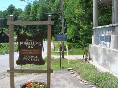
Operated Continuously As A
Store Until 1945. Believed
To Have Been A Stop On The
Underground Railroad. — — Map (db m57384) HM
Crescent When the Erie Canal opened in 1825, the commercial
focus in Halfmoon shifted to the village of Crescent
where the longest aqueduct on the system carried the
canal across the Mohawk River. That aqueduct was
replaced in 1842. Between . . . — — Map (db m128408) HM
On Sacandaga Road (New York State Route 147), on the right when traveling north.
1748 1929
In Memory
Of The Men Who Were Killed
In This Ravine In
The Beukendaal Battle
On July 18, 1748
By The Canadian Indians
John A. Bradt
Johannes Marinus
Peter Vrooman
Daniel Van Antwerpen
Cornelis Viele, . . . — — Map (db m102619) HM
On Union Street at North Church Street, on the right when traveling west on Union Street.
To honor the memory
of
Arendt Van Curler
Acknowledged leader of the
fifteen original settlers of Schenectady.
Born at Nijkerk, Holland, 1620;
Came to New Amsterdam, 1638;
To Schenectady, 1662;
Resided here until death. . . . — — Map (db m15029) HM
This locomotive, among the largest and most powerful on the Southern Pacific Railroad system, supported the growth and development of the San Joaquin Valley and the West.
Engine #2914, called a 4-8-0 because of its wheel . . . — — Map (db m25600) HM
On River Landing Road. Reported permanently removed.
The Choptank River was as entwined with the history of slavery and freedom on the Eastern Shore as any plantation. Slaves arrived by boat for auction and left the dock in the hands of a new owner. At wharves like this, black watermen played an . . . — — Map (db m79342) HM
On Main Street (New York State Route 146) at Gun Club Road, on the right when traveling west on Main Street.
Welcome to Altamont
The Village of Altamont and its immediate surroundings were once part of a tract of land deeded in 1630 by the Dutch West India Company to Killian Van Rensselaer (c. 1586-1643),a wealthy 17th century Dutch . . . — — Map (db m132693) HM
Sent to the Province of New York in 1737, by his uncle Sir Peter Warren for the purpose of supervising landed property in the Mohawk Valley, William Johnson engaged in trade with settlers and Indians.
Prospering in mercantile enterprises, he . . . — — Map (db m52124) HM
Near New York State Route 169 east of General Herkimer Road.
During the American Revolution, almost half of the military actions in New York State occurred along the strategic corridor of the Mohawk Valley. In 1777 British, Native American and Loyalist battalions attacked from the west and north. Defeats at . . . — — Map (db m66016) HM
On Schoharie Street south of Main Street, on the left when traveling south.
The partially water-filled ditch in front of you is a portion of the Erie Canal. Construction of this canal began July 4, 1817, in Rome, New York. The canal was dug in two directions at the same time, west toward Buffalo and east toward Albany. . . . — — Map (db m88433) HM
On Washington Street, on the left when traveling north.
John Baptist Van Epps
was a fur trader and also
operated a fleet of boats. At
this site he ran the ferry dock
at which George Washington
landed on one of his visits to Schenectady. — — Map (db m128741) HM
Near Nott Terrace Heights at Lewis Place, on the right when traveling east.
Site of
Nott Terrace High School
Athletic field built in
1925 for the former Schenectady
High School and other city
outdoor sporting events — — Map (db m197388) HM
During the American Revolution, almost half of the military actions in New York State occurred along the strategic corridor of the Mohawk Valley. In 1777 British, Native American and Loyalist battalions attacked from the west and north. Defeats at . . . — — Map (db m68007) HM
On East Park Place at East High Street (U.S. 27), on the left when traveling south on East Park Place. Reported missing.
Thomas Cowan Bell, James Parks Caldwell, Daniel William Cooper, Isaac M. Jordan, William Lewis Lockwood, Benjamin Piatt Runkle, and Franklin Howard Scobey met in a second floor room of this building to found Sigma Chi (ΣΧ) in early . . . — — Map (db m227310) HM
On Gap Road (Pennsylvania Route 741) east of Bishop Road, on the right when traveling east. Reported missing.
A Standard Freight Locomotive: With more than 3000 Consolidations on the roster by 1907, the 2-8-0 was clearly the Pennsylvania's locomotive of choice for freight service. Despite the success of current designs, the railroad continuously strove . . . — — Map (db m231570) HM
Twenty-five Big Boys, the world's largest steam engines, were built exclusively for Union Pacific by the American Locomotive Company in Schenectady, New York between 1941 and 1944. Each locomotive was 132 feet long and weighed 1.2 million pounds. . . . — — Map (db m95200) HM
On South 2nd Ave, 0.1 miles south of West Main Street (County Road 155), on the left when traveling south.
Route of a toll road from
Amsterdam to Fish House. It
linked the rural economy of
the Sacandaga Vly to rail
& canal access in Amsterdam
— — Map (db m47115) HM
On North Main Street at Court Street, on the left when traveling south on North Main Street.
[First Frame of Text]: Fort Dayton
During the American Revolution the residents of this area were protected by Fort Dayton. It stood right here, in the area bounded by North Main, East German, North Washington and Court . . . — — Map (db m54273) HM
On Road to Old Fort west of Canal Street (New York State Route 5S), on the left when traveling west.
First Frame of Text: Fort Plain Museum
Fort Plain, also known as Fort Rensselaer, was built 1778-79 on two-thirds of an acre of hilltop, an ideal strategic and defensive position. Families from nearby settlements retreated . . . — — Map (db m75301) HM
On State Street (New York State Route 5) at Washington Ave., on the right when traveling east on State Street.
Here St Georges Lodge No 6
F & AM Formed June 1774 Here
Washington Was Entertained
By Civil and Military
Authorities June 30, 1782
— — Map (db m51163) HM
On Broadway at Westinghouse Place, in the median on Broadway.
Born October 6, 1846 Central Bridge, New York
Died March 12, 1914 Buried in Arlington National Cemetery
Educated in Schenectady Attended Union College
Civil War Veteran of the Union Army and Navy 1863,1865
Founded Westinghouse . . . — — Map (db m134086) HM
Near Golden Spike Road (22000 West Road) near 6400 North Road, on the right when traveling west.
”More representative American locomotives of the period would be difficult to find. Both the Jupiter and 119 were of the eight wheel or 4-4-0 wheel arrangement. This style of engine was so common in the United States that it was called the . . . — — Map (db m80965) HM
The Seventy-Seventh Regiment, New York Volunteers
(Bemis Heights Battalion)
Third Brigade, Second Division, Sixth Corps.
Army of the Potomac.
1861 —— * —— 1865
Took part in all the campaigns of the Army of the . . . — — Map (db m40658) HM
On Schoharie Turnpike (County Route 74), on the right when traveling east.
in honor of
Mr. & Mrs. W.W. Christman
———————
"I Give, Bequeath, Devote, Devise,
Shelter to Every Bird That Flies"
———————
Dedicated by
The Mohawk . . . — — Map (db m7152) HM
Near Barrett Station Road east of Old Dougherty Ferry Road, on the right when traveling east.
Built by the American Locomotive Company (ALCO) in Schenectady, NY, this 4-4-0 is a "Camelback" or "Mother Hubbard" locomotive. It gets that name from the engineer's cab being located in its center, above the boiler. This is due to the wide . . . — — Map (db m132982) HM
Andrew was born on July 25, 1830, in Oakland County, Michigan, one of seven children, and was reared on a farm. His father, William, had served in the Continental Army during the American Revolution. Andrew attended the University of Michigan, and . . . — — Map (db m58201) HM
Near Submarine Way north of Bypass U.S. 1, on the left when traveling west.
Jim Sergeant enlisted in the US Navy on June 25, 1964. Following Boot Camp and internal Communications training, Jim served tours aboard the Naval Nuclear Power School, Vallejo, CA; Nuclear Power Training Unit, Schenectady, NY; and USS Tattnall . . . — — Map (db m186281) HM
On Broadway north of Steuben Street, on the left when traveling north.
In the dawn of American Railroads, the Mohawk and Hudson Line (1831), running between Albany and Schenectady, was one of the first built.
Juggling funding, inventions, public relations and sheer determination, this railroad evolved from a . . . — — Map (db m116703) HM
Near W Main Street (New York State Route 5) north of Caroline Street, on the left when traveling north.
Guy Park, Guy Johnson's manor house, was built here because boats on the Mohawk River offered the best way to move goods and people during the 1700s. Successive waves of transportation improvements - Mohawk Turnpike, Erie Canal, railroads, and Barge . . . — — Map (db m152505) HM
Between the Northumberland Dam and the Dix Bridge are the cut-stone piers of the old trolley trestle that crossed the Hudson River. For the better part of a century, a network of trolleys carried passengers between the tri-city (Albany, . . . — — Map (db m246311) HM
On Sacandaga Road (New York State Route 157), on the right when traveling north.
Dutch Word Meaning
Beechdale. DeGraff House
Where 40 Schenectady
Militia Fought Off French-
Indian Raiding Party
Town of
Glenville
— — Map (db m104952) HM
On Washington Ave. at Front Street, on the right when traveling north on Washington Ave..
1863
Home of Aaron Dickinson, blacksmith
and his wife Elizabeth
Home of J. Teller Schoolcraft while he was
Mayor of Schenectady (1914-1915)
Site of store owned by John Prince (New York
State Assembly member, after whom . . . — — Map (db m56484) HM
On Darrow Road, on the right when traveling north.
Home of Enoch Ambler
Inventor of First
Mowing Machine
Patent Signed by Pres.
Andrew Jackson in 1834
Heritage & Genealogical Soc. of Montg. Co
— — Map (db m68671) HM
On New York State Route 30 at Eastside Road, on the right when traveling north on State Route 30.
Longest single span wooden bridge in world. Built by Blenheim Bridge Company, incorporated 1828. Last of its kind in this region. — — Map (db m46984) HM
On Eastside Road, on the right when traveling south.
Erected 1854 - 1855 by
Nicholas Montgomery Powers
Famous bridge builder
Born Pittsford, Vermont, August 30, 1817
Died Clarendon, Vermont, 1897
This bridge, 232 feet in length, the
longest covered single-span wooden
bridge in the . . . — — Map (db m46983) HM
On Bridge Street (U.S. 17), on the right when traveling north.
Congressman from New York, 1821-39; House leader for Jackson & Van Buren; minister to Russia; merchant. Was born in this town, 1786. — — Map (db m65820) HM
On E. Ridgewood Avenue at Van Neste Square, on the right when traveling south on E. Ridgewood Avenue.
Brigadier General Abraham Godwin Soldier, Statesman, artist, poet, engraver, musician and gracious host. Born July 16, 1763.
His career began at the age of thirteen when his brother, David, aged eleven, he left home at Totowa to join Captain . . . — — Map (db m22133) HM
Near Center Avenue at 51st Avenue, on the left when traveling north.
Before the 1870s, Hunter's Point was a tidal wetland with meadows, sandy hills, rock outcroppings, marshes, and streams. Much of southern Hunter's Point, including this park, was under water.
Before the arrival of Europeans in the 17th . . . — — Map (db m241583) HM
On Ferry Drive, 0.1 miles south of Riverview Road, on the right when traveling south.
Nicholas Vischer (1705-1778) married Annetie Tymmersen in Schenectady in 1734. They settled here and built a little brick house where they raised six children. Their house, located not farfrom here, is the rear wing to a large two story Federal . . . — — Map (db m171540) HM
Near River Road (County Route 19) south of Line Drive, on the left when traveling south.
History of the John Brown Hiking Trails and Mohawk River State Park
Named for local preservationist, the John Brown Hiking Trails wind
through 100 acres on Niskayuna Town land and 117 acres on the
Mohawk River State Park, formerly the . . . — — Map (db m158316) HM
These stone arches are the remains of an aqueduct that conveyed the Erie Canal across the Plotter Kill Creek. Aqueducts were used to carry the canal and its towpath over rivers, ravines, and other obstructions. They each consisted of an arched . . . — — Map (db m125976) HM
On Main Street (New York State Route 10), on the left when traveling north.
Belief in the curative powers of sulphur water is central in Sharon Springs’ history. For two centuries the village, its inhabitants, its structures, and its fortunes were tied to and shaped by it. In pursuit of this belief an amazing variety of . . . — — Map (db m131011) HM
Local poet William (Bill) Bronk was born in Fort Edward, New York to William M. Bronk and Ethel Funston Bronk. He was a descendant of Jonas Bronck, for whom the Bronx was named. William Bronk grew up in nearby Hudson Falls and lived in the . . . — — Map (db m229506) HM
On Meadow Lane at Kokosing Gap Trail, on the right when traveling north on Meadow Lane.
This 0-6-0 switcher locomotive and tender were built by the American Locomotive Company (Alco) of Schenectady, N.Y., for the Alabama State Docks Commission in November 1940. Road number 63 was used to switch cargo at the docks in Mobile, Ala. . . . — — Map (db m13872) HM
Lt Hook was born March 12, 1917, in Albany, NY. He graduated from Union College in Schenectady, NY, attended Albany Law School, and was active in musical circles.
At 24, he responded to the Japanese attack on Pearl Harbor by enlisting in the . . . — — Map (db m121434) HM
On Grove Street at South Main Street, on the right when traveling east on Grove Street.
Fields of Indian Corn and Potatoes
The surrounding landscape was very different on
September 15, 1863, when the first Albany and
Susquehanna train rolled through from Albany to
Central Bridge. Passengers saw only farm fields of Indian corn . . . — — Map (db m185911) HM
On Broadway at Park Street, on the right when traveling north on Broadway.
Fonda 1836-1918 *
Mohawk Turnpike Improved 1800
Utica & Schenectady R.R. Built,
Station Named for Pioneer
Family 1836
Montogomery Co. Agricultural
Society Formed Oct. 13, 1844
First County Fair held at
Court House Nov. 11-12, 1844 . . . — — Map (db m59765) HM
On Schoharie Street south of Main Street, on the left when traveling south.
Long before the Erie Canal was constructed, Schoharie Crossing was home to a Mohawk village called the Lower Castle, which consisted of 40-50 houses surrounded by a defensive palisade. Following a request for missionaries made by Mohawk chiefs . . . — — Map (db m88534) HM
On 112th Street (New York State Route 470) at 1st Avenue, on the right when traveling west on 112th Street.
First chartered village in Rensselaer County, New York, USA and was settled around 1763. The name is from Abraham Lansing, an early settler, combined with the Scottish word burgh.
Street Docks at 123rd Street During the First . . . — — Map (db m115538) HM
The residents of Clifton Park have wanted a
bridge across the Mohawk River at Vischer
Ferry since the town was formed in 1828. An
act incorporating the Vischer's Ferry Bridge
Company was passed by the State Legislature on
April 19, 1828, . . . — — Map (db m171541) HM
In late July of 1812, a U.S. Army rifle company arrived on the Northern Border. It was commanded by Captain Benjamin Forsyth, "a big dashing daredevil from North Carolina," who had his own opinions on the way to wage a war. Along the Northern . . . — — Map (db m75732) HM
Family and Early Political Life
William Henry Seward was born in Florida, New York, on May 16, 1801. His father, a wealthy landowner, was a slaveholder prior to New York abolishing slavery in 1827. Seward would later become instrumental in . . . — — Map (db m181752) HM
On Atlantic Street at Vernon Street, on the right when traveling south on Atlantic Street.
The first suecessful rotary plow was designed by Canadian Orang Jull. Jull hired the
Leslie Brothers to build the first model with the first tests conducted in the winter of
1883-84. The Leslies soon purchased the manufacturing rights to the plow . . . — — Map (db m135381) HM
Near Cannon Road, 0.6 miles south of U.S. 280, on the right when traveling south.
Beginning in late 1944, the race to obtain the best speed and range obtainable from jet propulsion led to the Republic XP-84 becoming the first new fighter of the post WWII period. In 1949, Republic began experimenting with the YF-84 version which . . . — — Map (db m247272) WM
On Broadway at Maiden Lane, on the right when traveling north on Broadway.
Why is Albany Here?
Mohawk and Mahican peoples inhabited this region for thousands of years when the Dutch ship the Half Moon dropped anchor near this spot in 1609.
At that time, the world was in the midst of a "Little Ice . . . — — Map (db m116700) HM
On West Shore Boulevard at Whitbeck Road, on the right when traveling east on West Shore Boulevard.
A Vast Enterprise
The Erie Canal was a vast commercial enterprise that required an army of men, women,
and children to maintain and operate: surveyors,
engineers, lock tenders, toll collectors, bridge
operators, repair crews, and bank . . . — — Map (db m117641) HM
On Grove Street at Main Street, on the right when traveling north on Grove Street.
[ inscription around the top ]
In Everlasting Memory of Stamford's Patriots 1641 – 1918
[ battle names inscribed in the panel between the fluted columns ]
1689 – 1763
Port Royal • Schenectady • Haverhill • . . . — — Map (db m38430) HM
Minneapolis & St. Louis #457 History
1912 American Locomotive Company of Schenectady, N.Y. built the 457 for the Minneapolis and St. Louis Railroad at a cost of $18,456.03. The Consolidation type locomotive served 38 years for the M&StL, . . . — — Map (db m89634) HM
On McKinley Avenue just east of New York State Route 30, on the right when traveling west.
Site of the
Adirondack Inn
Built in 1891 by the FJG RR
Considered the Gem Of
Sacandaga Park this ornate
wood structure burned 1975
— — Map (db m11284) HM
On Western Turnpike (U.S. 20) near Duanesburg Churches Road (County Route 127), on the right when traveling west. Reported damaged.
Society of the Reformed
Presbyterian Church
Org. 1795 By Rev. McKinney
1st Ministers: Rev.
McMaster, Wylie, & Ramsay.
Present Edifice Built 1836
— — Map (db m41320) HM
Near Rome Oriskany Road (New York State Route 69) 0.4 miles east of Monument Road, on the left when traveling east.
(Center/Main Marker)
To The Unknown Patriotic Soldiers of Tryon County
Who Under The Leadership Of
Colonel Ebenezer Cox • Colonel Jacob Klock
Colonel Peter Bellinger • Colonel Frederick Visscher
Followed
— Herkimer — . . . — — Map (db m241579) HM WM
On Hudson River Road (U.S. 4) at Brookwood Road, on the left when traveling south on Hudson River Road.
Halfmoon
Halfmoon borders the Hudson and Mohawk Rivers, and once included the communities we now know as Clifton Park, Waterford, Mechanicville, and a portion of Colonie. The early Dutch fur traders, who met Mahican natives here to barter . . . — — Map (db m145329) HM
173 entries matched your criteria. Entries 101 through 173 are listed above. ⊲ Previous 100
* Inflectional forms of words are their plurals, singulars, and possessives as well as gramatical tenses and similar variations.