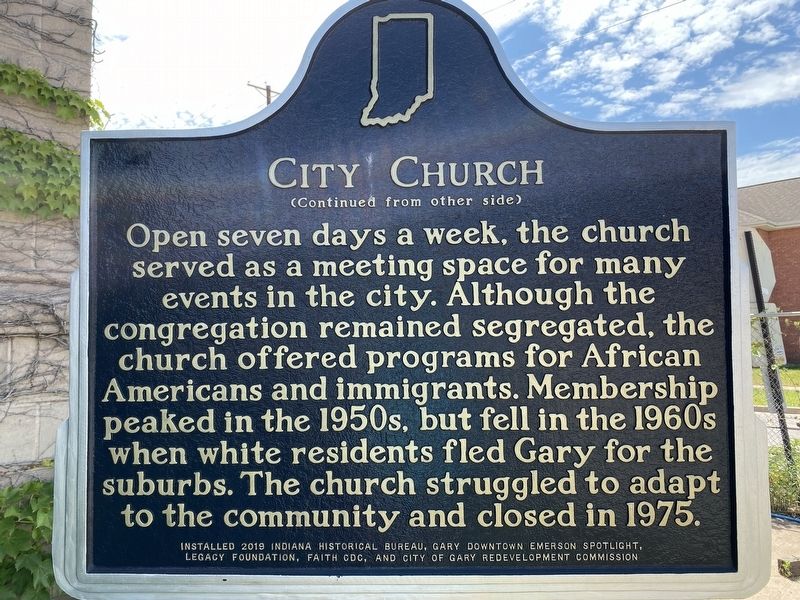
On West 6th Avenue at Washington Street, on the left when traveling east on West 6th Avenue.
In the early 1900s, immigrants, white migrants, and black southerners came to Gary for work in the steel industry. Rev. William G. Seaman founded City Church downtown in 1926 to serve as a Christianizing influence on the diverse population. The . . . — — Map (db m200385) HM
On East Dunes Highway (U.S. 12) at East 6th Avenue, on the right when traveling east on East Dunes Highway.
Dedicated to the memory of the men and women whose love for this nation enabled them to make the supreme sacrifice of life itself in its defense. — — Map (db m226841) WM
On East 4th Avenue (U.S. 12/20) at Broadway, on the left when traveling east on East 4th Avenue.
Gateway Park
This park, along with City Hall and the County Court Building, was envisioned by the Gary Commerce Club as a "front door" to the city. The City and the Gary Public Transportation Corporation (GPTC) used federal transportation . . . — — Map (db m240904) HM
On Ellsworth Street at Ellsworth Street, on the left when traveling south on Ellsworth Street.
In need of their own place to worship in the segregated city of Gary, a group of Black professionals helped establish St. Augustine's Episcopal Mission in 1927. In the late 1930s and 1940s, Benedictine monks, assigned by the Episcopal Diocese of . . . — — Map (db m298694) HM
On Taft St at W. 10th Ave, on the right when traveling north on Taft St.
St. John's Church, the oldest surviving institution in Gary and north of the Little Calumet River, began with the work of the Rev. Henry Wunder in the early 1860's. He regularly came from Chicago by horse and buggy. Baptism records date from 1863; . . . — — Map (db m200365) HM
On East Massachusetts Street at West 15th Avenue, on the right when traveling east on East Massachusetts Street.
Stewart House was organized during depression of 1921 to provide social services for Gary’s black community. A vital neighborhood center for unemployed WWI veterans and southern blacks who migrated for jobs in steel mills, it helped thousands . . . — — Map (db m200378) HM
Genesis Plaza - Omri Amrany's The Fusion Centennial Sculpture The 40' sculpture, often called "The Steelworkers' Monument," was completed and dedicated in 2006 and installed to mark Gary's centennial,. — — Map (db m240999) HM
On East 4th Avenue (U.S. 12/20) at Broadway, on the right when traveling west on East 4th Avenue.
During the 1920's, the population of Gary would double. In order to attract and keep good leadership. U.S. Steel needed quality housing available for its managers. Plans were soon conceived for a 68-unit apartment building near the heart of . . . — — Map (db m226732) HM
On East 4th Avenue (U.S. 12/20) at Broadway, on the right when traveling west on East 4th Avenue.
Gary's first Methodist Church was established in 1906. In October of 1916, Dr. William Gran Seaman became pastor. Seaman relished his role in the growing congregation, but he had bigger dreams; he wanted to build a new church to serve the . . . — — Map (db m227755) HM
On East 4th Avenue north of Broadway, on the right when traveling east.
Gary City Hall - Bryant Baker's Elbert H. Gary Statue
The bronze statue was sculpted and erected in 1927. Elbert Gary was the key founder of U.S. Steel, bringing together J.P. Morgan, Andrew Carnegie, and Charles . . . — — Map (db m241907) HM
On East 4th Avenue (U.S. 12/20) at Broadway, on the right when traveling west on East 4th Avenue.
Gary School Superintendent William Wirt used the Ralph Waldo Emerson School to be the first to use his new Work-Study-Play system of education, a "Whole Child" philosophy. This philosophy drew international attention to Emerson.
The building . . . — — Map (db m227754) HM
Architect Philip Brooks Maher's Gary City Hall Building
City Hall was completed in 1927 by Philip Maher after his father and original architect George W. Maher's death. George drafted a Prairie-style design while . . . — — Map (db m241909) HM
On Broadway at 5th Avenue, on the right when traveling north on Broadway. Reported damaged.
The founding of Gary in 1906 occurred at a time when electric street cars were booming in cities across the country. Provisions were made in the original layout of Gary for electric passenger car rail lines to be placed down the middle of major . . . — — Map (db m241910) HM
This house was the first permanent structure built in Gary, and was the home of Gary's first town hall, polling place, post office, and high school. In 1981 the house was placed on the National Register of Historic Places, and restored in 1982 . . . — — Map (db m253237) HM
On East 4th Avenue (U.S. 12/20) at Broadway, on the right when traveling west on East 4th Avenue.
Gary Public Library (GPL) was organized on March 30, 1908 when its first library board met, and Ora L. Wildermuth, Gary Public Library's founder, moved "that we have a Public Library and that the Board proceed to arrange for the same." The . . . — — Map (db m254713) HM
On East 4th Avenue (U.S. 12/20) at Broadway (Indiana Route 53), on the right when traveling west on East 4th Avenue.
In 1906, a two-level building was erected on the corner of Sth Avenue and Broadway and became the Gary State Bank which operated in the building above until it was razed in 1925 to make way for a new high-rise building.
On East 4th Avenue (U.S. 12/20) at Broadway, on the right when traveling west on East 4th Avenue.
At first, Horace Mann consisted of two portable trailers near the street on the large property. The first class consisted of 45 students who had previously attended Jefferson School. Demand for the west side school was greater than initially . . . — — Map (db m248460) HM
On East 4th Avenue (U.S. 12/20) at Broadway, on the right when traveling west on East 4th Avenue.
Shortly after the city's founding by U.S. Steel in 1906, the Gary Heat, Light, and Water Company constructed the utilities necessary for tens of thousands of new residents and businesses. The company hired civil engineer John W. Alvord of . . . — — Map (db m226733) HM
On Broadway at 5th Avenue, on the right when traveling north on Broadway.
500 Broadway - Jason Bord's Lake Wind Sand Composition Sculpture
This piece, installed in 2018, was part of a public art contest supported by the City of Gary, Legacy Foundation, and the Knight Foundation. The . . . — — Map (db m241912) HM
On Massachusetts Street, on the right when traveling north.
Gary City Hall - Gary Tillery's Mayor Richard G. Hatcher Statue
This statue honors Mayor Hatcher, one of the first two black mayors to be elected in major cities in the U.S. The bronze statue celebrates this . . . — — Map (db m241908) HM
On East 4th Avenue (U.S. 12/20) at Broadway, on the right when traveling west on East 4th Avenue.
Gary Public Schools Memorial Auditorium was built in 1927 to honor Gary residents who died in World War I. It was part of an emerging movement to build structures of significant public utility rather than traditional monuments.
On Massachusetts Street south of East 4th Street (U.S. 20), on the left when traveling north.
In 1967, Mayor Richard Gordon Hatcher became the first elected African American mayor of a major US city. A civil rights luminary, Mayor Hatcher served as advisor to Presidents Lyndon B. Johnson and Jimmy Carter on issues of civil rights and urban . . . — — Map (db m236263) HM
On Broadway north of Interstate 90, on the right when traveling north.
Built in 1910, just four years after the city was founded, the station is located between the elevated lines of the Norfolk Southern and CSX Railroads. The station transported the thousands of workers who came from around the country to work in . . . — — Map (db m236260) HM
On Oak Avenue 1 mile west of Montgomery Street, on the right when traveling west.
The glider you see above you and to your left was designed by Octave Chanute, whose statue you see on your right. In June of 1896 (ten years before Gary, Indiana was founded), Chanute, a leading civil engineer, came across Lake Michigan from . . . — — Map (db m227829) HM
This is to certify that Gary Bathing Beach Aquatorium was placed on the National Register of Historic Places on the 25th day of November 1994 by the United States Department of the Interior in cooperation with the Indiana Department of Natural . . . — — Map (db m226861) HM
Near Oak Avenue west of Montgomery Street, on the right when traveling west.
In 13,000 BC the shoreline of Lake Michigan was several miles south of this marker, at what is now Ridge Road. As the lake receded over the centuries the shoreline inched north to where you are standing. In 1675 Jesuit explorer Father Marquette . . . — — Map (db m236264) HM
On Marquette Drive at Oak Avenue, on the left when traveling east on Marquette Drive.
A French Jesuit Priest. One of the earliest Christian teachers of the American Indians landed here AD 1673 in company with the French explorer Louis Joliet. — — Map (db m226864) HM
On Oak Avenue at North Grand Boulevard, on the left when traveling south on Oak Avenue.
Marquette Pavilion, built in 1924, is an example of prairie-style architecture.
Can you find these features that are emblematic of this style?
• Strong geometry and massing
• Horizontal and vertical lines
• Brick or stucco exteriors . . . — — Map (db m227758) HM
On Oak Avenue west of Montgomery Street, on the right when traveling west.
Octave Chanute arrived at Miller Beach, Gary, Indiana on June 22, 1896 to perform gliding flight experiments in the dunes just west of this site. Over 700 successful flights provided him with significant aerodynamic data.
Chanute willingly . . . — — Map (db m227760) HM
On Oak Avenue west of Montgomery Street, on the right when traveling west.
Octave Chanute, a French-born engineer, is celebrated for his pioneering aviation experiments here on the dunes of Lake Michigan. He was an innovator for railroads as well.
He designed wood and iron trestle bridges for some of the most . . . — — Map (db m227830) HM
On Oak Avenue 1 mile west of Montgomery Street, on the right when traveling west.
Made the first successful flights in heavier-than-air craft from these dunes in 1896. This glacial boulder dedicated to his memory in 1936. — — Map (db m236259) HM
On Oak Avenue 1 mile west of Montgomery Street, on the right when traveling west.
The figure of Octave Chanute is pointing toward the dune where, in July of 1896, he conducted his famous experiments with gliders. These experiments had a dramatic impact on the history of aviation. The publicity generated by the experiments . . . — — Map (db m227824) HM
Near Oak Avenue north of Marquette Drive, on the right when traveling south.
For decades people have enjoyed strolling the bridges to Patterson Island. The small island located in the Grand Calumet Lagoon was enhanced for access during the Great Depression through the Works Progress Administration (WPA). . . . — — Map (db m226859) WM
Near Oak Avenue west of Montgomery Street, on the right when traveling west.
Of the estimated 1,500 shipwrecks in Lake Michigan, there are 14(*) within Indiana waters. Two lie offshore of Gary. They are identified only as "Unknown 5" and "Unknown 6."
"Unknown 5 and 6" have been identified by archeologists as barges . . . — — Map (db m226863) HM
On Oak Avenue west of Montgomery Street, on the right when traveling west.
World's largest freshwater sand dunes in the world line the southern shores of Lake Michigan.
5th largest lake in the world and largest lake in Indiana.
Over 3,500 ships and planes lay at the bottom of Lake Michigan.
You are . . . — — Map (db m226866) HM
Near North Lake Street north of East 3rd Avenue, on the right when traveling north.
The Water Tower of Northwest Indiana Water Company has been a fixture on the Gary skyline since the birth of the city. The concrete structure is 150 feet tall and encloses an elevated, 290,000 gallon capacity, cylindrical steel tank. Originally, the . . . — — Map (db m249547) HM
On Oak Avenue 0.2 miles west of Montgomery Street, on the right when traveling west.
In 1941 the American military did not want the Tuskegee Airmen to fly. By May 8, 1945, the end of World War II in Europe, only the Nazis felt that way.
The heroics of the Tuskegee Airmen led to President Truman's 1948 order ending racial . . . — — Map (db m227759) HM WM
Near Schrage Avenue south of John Street, on the right when traveling south.
As the saying goes,"You cannot have a great building on a weak foundation." The same thought applies to building a business, and for the Schrage Family and Centier Bank, the same applies to building a culture as well. While Henry and Walter Sr. . . . — — Map (db m256564) HM
Near Schrage Avenue south of John Street, on the right when traveling south.
Henry Schrage (1844-1932) was born into one of the first families of Whiting. An entrepreneurial spirit, he learned a strong work ethic from his humble beginnings as a German immigrant. Upon returning home after serving in the Union Army in the . . . — — Map (db m256487) HM
On Schrage Avenue at West Fred Street, on the left when traveling north on Schrage Avenue.
On this site the former Immaculate Conception Church and School stood from 1924 until it was razed in 2018. Rev. Michael Kosko celebrated the first Mass at Midnight, on Christmas Eve, 1924. The last Mass was celebrated on Sunday, March 2, 2014, at . . . — — Map (db m256574) HM
On Schrage Avenue south of John Street, on the right when traveling south.
The original Schrage family mansion is located at 2006 Schrage Avenue. Henry Schrage lived in this home with his wife, Carolina, and their six children. Henry was a naturalist, whose hobbies included beekeeping and birdwatching. He jokingly . . . — — Map (db m256485) HM
Near 119th Street at Oliver Street, on the right when traveling west.
In Thanksgiving to God and in lasting memory ot the men and women who served their country in all wars
Renovation Contributors:
City of Whiting, Whiting City Council, School City of Whiting, American Legion Post 80, American Legion Auxiliary . . . — — Map (db m256399) WM
On 119th Street at Schrage Avenue, on the left when traveling west on 119th Street.
During the course of America's involvement in Vietnam, over 58,000 U.S. service men and women lost their lives. Although it was never officially classified as a "war," Vietnam was America's longest period of continuous combat, 1959 - 1975, prior to . . . — — Map (db m256396) WM
On Indianapolis Boulevard at 119th Street, on the right when traveling north on Indianapolis Boulevard.
For over eight decades, White Castle fed the souls of craver generations on this very site. Creating countless memorable moments, and feeding the souls of craver generations along the way. In fact, we estimate that we served over 105 million . . . — — Map (db m256393) HM
On Washington Street at W. 7th Street, on the right when traveling south on Washington Street.
Given to the people of Michigan City as a cultural and civic center by Mrs. Catherine Barker Hickox in 1968. The original house was built on this site (circa) 1858 by John Barker Sr. (1814-1878). It was reconstructed in 1901 by John H. Barker . . . — — Map (db m77403) HM
On Washington Street at West 7th Street, on the right when traveling south on Washington Street.
The mansion before you was built by freight car magnate John Barker, Sr. in 1857.
Barker lived in this home with his wife, Katherine, and daughter, Catherine. Tragically, both parents died in 1910, making Catherine the world's richest . . . — — Map (db m273351) HM
On Liberty Trail at E. 8th Street, on the right when traveling north on Liberty Trail.
In the aftermath of George Rogers Clark’s conquest, skirmishers from Cahokia led by Capt. B. Hamelin and Lt. T. Brady, who had raided Fort St. Joseph, were defeated and captured near here by fur-trader Etienne Champion and Potawatomi allies of the . . . — — Map (db m72908) HM
On East Michigan Avenue (U.S. 35) at Carroll Avenue on East Michigan Avenue.
One of three Civil War training camps in La Porte County. Site is one fourth mile west. Named for Colonel Edward Anderson. Used 1863-1864 to train Indiana Union volunteers of the 127th, 128th, and 129th regiments. — — Map (db m969) HM
On East Michigan Boulevard east of West Michigan Boulevard (U.S. 12), on the left when traveling east.
Westcott Park, a gateway to Michigan City, is dedicated in memory of Charles R. Westcott, whose lifetime of extraordinary service, especially to children, significantly enriched our community.
For nearly 50 years, Westcott . . . — — Map (db m202852) HM
Near Springland Avenue west of South Karwick Road, on the left when traveling west.
The U.S. Fish & Wildlife Service and Great Lakes Fishery Commission work in partnership with the Indiana Department of Natural Resources to control sea lampreys in the Great Lakes. Tributaries harboring larval sea lampreys are periodically treated . . . — — Map (db m299132) HM
On East 8th Street at Spring Street, on the right when traveling east on East 8th Street.
The role of education is well-evidenced in two of the largest buildings in the district. The Public Library and the Central School were constructed on opposite sides of East 8th Street. While other schools were constructed in Michigan City, . . . — — Map (db m202871) HM
On North Franklin near East 6th Street, on the right when traveling north. Reported damaged.
One of the town's founding families, the Barker's, have patronized Trinity Episcopal Church throughout its history. Among the earliest recorded services at the church was the 1841 wedding of Cordelia Collamer to John Barker, Sr. He and his son, . . . — — Map (db m310322) HM
On Franklin Street at West 9th Street, on the right when traveling south on Franklin Street.
As retail crept south from the original center of town near 4th and Franklin, several churches became a part of the commercial district which had been constructed long before retail businesses moved south. Three churches in the district, St. John's . . . — — Map (db m310319) HM
On Franklin Street near West 4th Street, on the right when traveling south.
The first commercial business in Michigan City was established by Samuel Miller in 1833. Miller started a store supporting grain trade by farmers who brought products to the port. Several more warehouses were built as vessels on Lake Michigan began . . . — — Map (db m310336) HM
In 1845 Lodner Darvontis Phillips invented and launched the first submarine on the Great Lakes in Trail Creek at the foot of the Old Lighthouse. Phillips designed his submarines for salvage and warfare. His cigar-shaped design was the forerunner of . . . — — Map (db m244320) HM
On Wabash Street north of West 6th Street, on the right when traveling north.
The original plat of Michigan City was enlarged during the 1850s on the east and west sides. The Haskell & barker Historic District comprises approximately twenty-five blocks lining Washington and Wabash Streets on the near west side of downtown . . . — — Map (db m244464) HM
Hoosier Slide was located directly across the harbor. Standing over 200 feet high, it was for centuries a landmark for the Indians traveling the lake and later for French explorers. In modern times it was a great tourist attraction. With the . . . — — Map (db m244319) HM
On W. Michigan Blvd (U.S. 12) at Washington Street, on the right when traveling east on W. Michigan Blvd.
Presented by
The Daughters of Union Veterans
of
the Civil War - 1861-1865
In memory of
our Fathers and
The Grand Army of the Republic
June 12, 1939 — — Map (db m72910) WM
Near Lake Shore Drive 0.1 miles west of Franklin Street.
This lighthouse built in 1858 replaced 1837 lighthouse built at water's edge. Remodeled in 1904. Light placed at end of pier. Seven keepers and fourteen assistant keepers served here 1837-1940. — — Map (db m75722) HM
1941 — 1945
Dedicated To
The Memory
Of These
Our Boys
And All Who Served in
World War II
Gilford Albertson S.M. 3/C • Sgt. James Allie • Lt. Walter Baranowski • Cpl. Stanley Batuzik • Pvt. Bernard Baxter • Ens. John T. . . . — — Map (db m77402) WM
On Franklin Street 0.1 miles south of Lake Shore Drive, on the right when traveling south.
This historic site once the location of the Smith Brothers Cough Drop Factory, has been dedicated by the city of Michigan City for the use and enjoyment of all of its
citizens and visitors. We commemorate the celebration of the New Millennium and . . . — — Map (db m270163) HM
On East Michigan Boulevard east of West Michigan Boulevard (U.S. 12), on the left when traveling east.
Naomi Bowman Talbert Anderson was born on March 1, 1843, in Michigan City, Indiana. Her parents, Elijah and Guilly Ann Bowman were born free people of color. Although schools in Indiana were segregated, Naomi was invited to enroll in Michigan . . . — — Map (db m202851) HM
Near Lake Shore Drive 0.1 miles west of Franklin Street, on the left when traveling west.
Rank and Organization: Private First Class, U.S. Marine Corps, Headquarters and Service Company, 3d Battalion, 5th Marines, 1st Marine Division. Place and Date: Fire Support Base Tomahawk, Quang Nam Province, Republic of Vietnam. 1 March 1969. . . . — — Map (db m77364) HM WM
On Franklin Street 0.1 miles south of Lake Shore Drive, on the right when traveling south.
Roger McKee was a talented and visionary civic leader. This fountain
is dedicated to his decades of public service and humanitarian causes.
His proudest accomplishments were the preservation of the land
which this Millennium Plaza is located . . . — — Map (db m163391) HM
The S.S. Eastland was a Great Lakes excursion ship bound for Michigan City, Indiana from Chicago, Illinois on July 24, 1915.
With 2,501 passengers on board, the ship capsized during boarding while in the Chicago River. Tragically, 844 lives . . . — — Map (db m244411) HM
Near Greenwood Avenue at Wrobel Avenue, on the right when traveling east.
In Memory of Our Heroes
Who Died for Their Country
In World War II
May They Rest in Peace
T/SGT. Frank Skwiat 5–1943 • ENS. Ed. P. Komasinski 12–1943 • G.M. 1/C Ted. Pytynia 1–1944 • E.M. 2/C Matthew S. . . . — — Map (db m77445) WM
On West 10th Street at Buffalo Street, on the right when traveling east on West 10th Street.
Parish formed 1 Nov 1867 by merger of St. Ambrose 1849 & St. Mary 1859. Built on site of 1st Catholic cemetery in area on land purchased 1852 by Bishop of Vincennes. Cemetery moved to Calvary 1868. Church architect John Renkawitz; F.X. Zettler . . . — — Map (db m292861) HM
Near W. 10th Street at Buffalo Street, on the right when traveling east.
(Front Panel)
1917 1919
In Piam Memoriam
Erected to the greater glory
of God
And in memory of these four
young men of St. Mary's Parish
who made the supreme sacrifice
of their lives for God and Country
. . . — — Map (db m77393) WM
On East Michigan Boulevard (U.S. 12) at Pine Street on East Michigan Boulevard.
Assassinated President Abraham Lincoln’s funeral was April 19, 1865 at the White House. The funeral train left for Springfield, Illinois April 21 directed by military; stops en route allowed the public to pay homage. From Indianapolis, train . . . — — Map (db m60670) HM
On Franklin Street 0.1 miles south of Lake Shore Drive, on the right when traveling south.
Constructed on the east side of Trail
Creek, Washington Park has been Michigan
City's dominant playground for over 100
years. The park's lakeside setting includes
the Michigan City Lighthouse and Pier
built in 1858/1904. First established as . . . — — Map (db m163374) HM
On Lake Shore Drive, on the right when traveling west.
The Washington Park Zoo began in 1928, due in large part to cast-off or injured exotic animals and pets once cared for by the fire department. During the Great Depression, New Deal programs under the Works Progress Administration assisted the . . . — — Map (db m201678) HM
On Wabash Street at West 5th Street, on the right when traveling north on Wabash Street.
Imagine it's the late 1800s. Instead of the nearby outlet mall, you see the largest industrialized plant east of the Mississippi River.
The Haskell & Barker Car Company occupied this area from 1855 to 1922. The freight car factory was run by . . . — — Map (db m273349) HM
On Wabash Street at West 10th Street, on the right when traveling south on Wabash Street.
One of the most striking features of the Haskell & Barker Historic District is the number of large churches with tall spires that include St. Mary's Catholic Church, St. Stanislaus Catholic Church, the First Congregational Church, and the First . . . — — Map (db m292860) HM
On W. Lake Front Dr 0.1 miles east of Dunbar Ave, on the right when traveling east.
"Century of Progress" homes at the 1933 Chicago World's Fair showcased innovative building materials and designs. Visitors marveled at modern features like dishwashers and air conditioners.
In 1935, developer Robert Bartlett brought five . . . — — Map (db m64158) HM
Near East Lake Front Drive west of Broadway, on the right when traveling west. Reported missing.
Here you can surf the waves, stroll the shoreline, and see the dunes, but you are not at the ocean. Lake Michigan is part of the world’s largest fresh water system–the Great Lakes. Extending northward for 307 miles and averaging 118 miles from . . . — — Map (db m298190)
Near East Lake Front Drive west of Broadway Street, on the right when traveling west. Reported missing.
1. Dig a huge hole with a glacier. Use the ice to grind up millions of tons of rock and dirt and make ridges around the edge of the hole.
2. Fill the hole with glacial meltwater. Stir your brand new lake with strong prevailing northwest . . . — — Map (db m298189)
Near E. Lake Front Drive west of Broadway, on the right when traveling west.
He laid the foundation of the National Park Service defining and establishing the policies under which its areas shall be developed and conserved unimpaired for future generations. There will never come an end to the good that he has done. — — Map (db m72891) HM
Near East Lake Front Drive west of Broadway, on the right when traveling west. Reported missing.
Indigenous (native)
If you dove into the waters of Lake Michigan thousands of years ago, you would have disturbed the home of many indigenous species, such as lake trout, lake whitefish, yellow perch, and lake sturgeon. These healthy native . . . — — Map (db m298191)
On West North Boo Road just south of Navaho Trail, on the left when traveling north.
In the early 1900s steel plants were developed on southern Lake Michigan to improve access to growing Midwest markets. After purchasing 3,300 acres in Porter County, Bethlehem Steel built and began its Burns Harbor operations in 1964. The plant's . . . — — Map (db m202720) HM
On Broadway Avenue near South 2nd Street, on the right when traveling west.
This bandstand is one of the few remaining original bandstands in Indiana. It is noteworthy for its octagonal shape and high peaked roof which make it a notable exception to most bandstands of its time, which were square in shape. Verne L. . . . — — Map (db m267316) HM
On South Calumet Road at Broadway Avenue, on the left when traveling north on South Calumet Road.
Known at various times as Coffee Creek (1833), Calumet (1852), and Chesterton (1870), Chesterton, Indiana became a center for business and trade upon the arrival of the Lakeshore Railroad in 1852. With its proximity to the railroad, Main Street, . . . — — Map (db m266936) HM
Dunes Nature Preserve
has been designated a
Registered Natural Landmark
This site possesses exceptional value
as an illustration of the nation's natural
heritage and contributes to a better
understanding of man's environment . . . — — Map (db m267977)
On County Road 100E, on the left when traveling east.
…our parks and preserves are not mere picnicking places. They are rich storehouses of memories and reveries. They are a solace to the aged and an inspiration to the young.
Richard Lieber, Founder
Indiana State . . . — — Map (db m281874) HM
On Bowser Avenue just west of Jeffrey Street, on the left when traveling west.
Ludstron Home
All steel porcelain enameled
Erected 1950
has been placed on the
National Register
of Historic Places
by the United States
Department of the Interior — — Map (db m152862) HM
Near East Porter Avenue west of Indiana Route 49, on the right when traveling east.
Killed in action
June 2, 1971
Thua Thiên, South Vietnam
In the morning hours of June 2. 1971 U.S. Army scout dog handler Mark Randall Taylor and his loyal U.S. Army scout dog Krieger (65M8) were executing a scouting patrol to detect a hidden . . . — — Map (db m268682) HM WM
149 entries matched your criteria. The first 100 are listed above. The final 49 ⊳