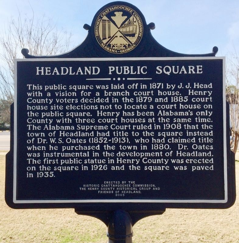
On Main Street 0.1 miles south of Alabama Route 173, on the right when traveling north.
Headland, Alabama
James Joshua Head (1839-1927) founded Headland in 1871 as Head’s Land. He patented land, platted the town and built his home. The Post Office opened, as Headland, on October 10, 1871. J. J. Head sold Headland to Hosey C. . . . — — Map (db m71817) HM
On Museum Avenue, on the right when traveling north.
In 1858, the tiny Poplar Head community requested a post office. Since there was a town called Poplar Spring in the state, the postal authorities arbitrarily assigned the name Dothan to the new post office to prevent misdirected mail. Early maps and . . . — — Map (db m41137) HM
Near Valley View Drive west of Richard Arrington Jr Boulevard South.
Side 1 - Building the Park
In the mid-1930’s, civic leaders worked to move Vulcan to a place of honor on Red Mountain. The park was built through the combined efforts of several groups: the Kiwanis Club of Birmingham, the Birmingham Parks . . . — — Map (db m83807) HM
Near Richard Arrington Junior Boulevard South 0.4 miles south of 16th Avenue South, on the right when traveling south.
The origins of this park date to 1923, when the Kiwanis Club of Birmingham
spearheaded the drive to successfully create a comprehensive park system
for the Magic City. In 1925, the Olmsted Brothers landscape firm revealed
A Park System for . . . — — Map (db m189282) HM
Near Valley View Drive west of Richard Arrington Jr Boulevard South.
The giant, cast iron statue you see towering above you is Vulcan, the Roman god of metalwork and the forge. The 56-foot tall statue was commissioned by Birmingham leaders to represent their new, growing city at the 1904 St. Louis World's Fair. After . . . — — Map (db m26297) HM
On South Broadnax Street at Eufalla Street, on the right when traveling south on South Broadnax Street.
Fletcher Farrington, after graduating from the Alabama Polytechnic Institute (now Auburn University), came to Tallapoosa County as a county agent for the Agricultural Extension Service in 1932. Concluding that soil erosion was the local farmers . . . — — Map (db m95105) HM
On East County 5th Street near South Avenue 39 East, on the right when traveling east.
who carved this farm out of the desert. We, the Wellton-Mohawk Valley Kiwanis Club, dedicate this spot. Here on May 1, 1952 Michael W. Straus, United States Commissioner of Reclamation turned the first water on to lands of the Wellton-Mohawk . . . — — Map (db m28967) HM
On East Walnut Street (State Highway 22/109) near Airport Industrial Road.
In late September 1863, Confederate Col. J.O. Shelby's cavalry headed north to raid into Missouri. On Sept. 27, 1863, Shelby's scouts found Co. H, 1st Arkansas Infantry (U.S.) camped at Haguewood Prairie near present-day Paris. The Union troops . . . — — Map (db m129518) HM
{The marker consists of 3 plaques, the first reading:}
A millstone from the steam powered flour mill built in 1880 by Albert Papst. It is believed the stone came from France. Fire destroyed the four storied mill in 1881.
. . . — — Map (db m41834) HM
Near Route 206 4 miles west of Newville Road (Route 200), on the right when traveling west.
Dedicated to the Noah Simpson family, early
settlers of Stony Creek Valley. The steel girders that form the arch were part of
the original bridge constructed in 1885 and
used until 1961. This site overlooks the
location of the original bridge . . . — — Map (db m172451) HM
On Foothill Boulevard at La Canada Boulevard, on the right when traveling west on Foothill Boulevard.
Within the soul of America is the freedom of mind and spirit
in man. Here alone are the open windows through which pour
the sunlight of all the human spirit. Here alone human
dignity is not a dream but a major accomplishment.
- Herbert . . . — — Map (db m291504) HM
On Chapman Avenue at Marks Way, on the right when traveling west on Chapman Avenue.
Major Fremont and the California Battalion marched from
San Diego to join Commodore Robert F. Stockton in the
first (August 13, 1846) occupation of Los Angeles.
California's governor Pio Pico, fleeing to Mexico to
avoid capture by the . . . — — Map (db m241272) HM
On Handy Street at Katella Avenue on Handy Street.
In 1870 Joel B. Parker, his wife, Mary, and daughter Ida came to Orange County. They purchased acreage from the Leandro Serrano allotment and completed the Octagon House in 1876. This site faced onto Villa Park Road (Katella). Cement used in . . . — — Map (db m241271) HM
On Taylor Road west of Horseshoe Bar Road, on the right when traveling west.
Loomis
Named After
James Oscar Loomis
1830 – 1895
This community was founded in 1850 and originally named “The Grove” by gold miners who settled along Secret Ravine one mile east of here.
Forming . . . — — Map (db m91090) HM
On Euclid Avenue (California Route 83) near C Street, in the median.
This fountain was built by the Women's
Christian Temperance Union and dedicated
to this City of Ontario on July 4th 1908, to
provide the town with "a drinking fountain
where only the pure, sparkling water
can be had at any time by the . . . — — Map (db m37513) HM
This route was opened by Captain Juan Bautista de Anza and Father Francisco Garces in 1774. Anza's expedition of 1775, a group of 240 soldiers and settlers being led from Sonora to found San Francisco, encamped near this place El Vado (The Ford), . . . — — Map (db m51586) HM
Near Washington Avenue south of 10th Street, on the right when traveling south.
Seven members of the Boston Mechanics’ Mining & Trading Company, namely George West (President), Walter Pollard, James MacDonald (Business manager), Mark Leonardo Blunt (later Postmaster), James McIntyre, Lawrence Panton, and Joseph T. Bird . . . — — Map (db m288327) HM
On 8th Street (State Highway 285) north of Pitkin Avenue, on the right when traveling north.
This park is dedicated to Otto Mears, Russian-born Colorado Pioneer, know as “The Pathfinder of the San Juan”, who came to the San Luis Valley in 1865. In Saguache (A Ute Indian word meaning “blue earth”), Otto Mears was married in 1870, . . . — — Map (db m120163) HM
Near Cedar Street (Connecticut Route 175) at Mill Street, on the left when traveling west.
Our Newington Veterans
Forever Loved
Forever Mourned
Presented by the Kiwanis Club
Of Newington and Caring Community
Citizens
1986
World War I
Howard G. Davis • Frank A. Stotzer • Clifford E. May
World War II
Russell Ahlgren • . . . — — Map (db m46043) WM
On Atlantic Street at Main Street, on the right when traveling north on Atlantic Street.
1776 1976
First Congregational Church
A crude, square, wooden structure surrounded by a stockade was erected near this site in 1641-2. It was the first meeting house of the Church of Christ. Later the First Congregational Church. Four members . . . — — Map (db m38752) HM
On Grove Street at Main Street, on the left when traveling north on Grove Street.
1776 1976
St. John's Episcopal Church
In 1774, St John's, the first Episcopal Church in this area, was built here on land granted by the town. Struck by lightning that same year, the original building was repaired and endured for a hundred . . . — — Map (db m38767) HM
On Westover Road, on the right when traveling south.
1776 1976 In August, 1781 Gov. Jonathan Trumbull and the Council of Safety ordered construction of fortifications near Stamford to prevent a surprise attack from the enemy. Designed by Col. Rufus Putnam, and erected and garrisoned by . . . — — Map (db m53433) HM
On 15th Street Northwest at G Street Northwest, on the right when traveling south on 15th Street Northwest.
Friendship between the United States and Canada was developed and strengthened by the signing of the Webster-Ashburton Treaty, on August 9, 1842, in the old State Department building which stood on this site. This treaty established the north . . . — — Map (db m17617) HM
On L Street Northwest 0.1 miles west of 24th Street Northwest, on the right when traveling west.
Peace through limitation of naval armament was promoted between the Dominion of Canada and the United States of America by the signing of the Rush-Bagot Agreement, April 28 and 29, 1817, providing for the restriction of naval forces on the Great . . . — — Map (db m98790) HM
On South De Villiers Street south of Whibbs Drive, on the right when traveling south.
(front)
The 1955 Pensacola Jaycees was the first Black Little League team to compete against a white team in the segregated South. Known as the Pensacola Negro team, the Jaycees became Northwest Florida's Little League champions after . . . — — Map (db m257397) HM
On Tamiami Trail/14th Street West (U.S. 41 BUS) just north of 23rd Avenue West, on the left when traveling north.
BRADENTON KIWANIS CLUB
The Bradenton Kiwanis Club was originally chartered on August 22. 1922 as the Manatee River Kiwanis Club. Later the name of the club was changed to Kiwanis Club of Bradenton. Founding members. Robert M.
Beall, Whitney . . . — — Map (db m236503) HM
Near Rio Grande Avenue just north of West Church Street, on the right when traveling north.
The Pensacola Jaycees & Orlando Kiwanis broke Florida’s color barrier in youth baseball on Optimist Park Field at Lake Lorna Doone. The coaches, players and their families stepped beyond the segregated patterns of the day living into the reality . . . — — Map (db m194559) HM
On West International Speedway Boulevard (U.S. 92) west of White Street, on the right when traveling west.
Crossed north to south near this site. This road was constructed from 1763-1773 by the English, connecting St. Augustine north to St. Mary's River and south to New Smyrna, Florida. First originated as an Indian trail, and later improved by the . . . — — Map (db m45478) HM
Near State Road 67 0.3 miles south of Burkhalter Road, on the left when traveling south.
Kiwanis Ogeechee Fair
Chartered in 1960, the Kiwanis Club of Statesboro conducted agricultural fairs in 1963 and 1964 on open lots on Stockyard Road as fund raisers. After torrential rains nearly ruined the 1964 fair, the club purchased 28 . . . — — Map (db m197933) HM
On Haynes Street at Washington Avenue, on the right when traveling north on Haynes Street.
Judge Debra Halpern Bernes was a loving and devoted wife and mother to her husband, Gary, and children, Lane and Matthew. She served her community as an Assistant District Attorney for Cobb County, a solo practitioner of law and as an elected judge . . . — — Map (db m54702) HM
Lawyer, Legislator, Mayor, Judge Robert Flournoy moved to Marietta from Atlanta in 1957 to practice law. He served in the Georgia House 1963 – 1965, creating the Cobb State Court. Flournoy founded the Downtown Marietta Development Authority in . . . — — Map (db m46618) HM
On 6th Street just north of Reynolds Street, on the left when traveling north.
Seventy one Augusta business leaders organized the Kiwanis Club of
Augusta in early 1920, as a "force for advancement and striving for
betterment along all lines of the city and its interests." Chartered
by Kiwanis International on February 23, . . . — — Map (db m282003) HM
Near S. Upper Blacks Creek Road 1.3 miles north of E. Blacks Creek Road.
From this old Indian trail later known as the Old Oregon Trail Captain B,L,E, Bonnevilles partner on first sighting the river May 1833 exclaimed - Les Bois Les Bois Voyes Les Bois meaning The Woods The Woods See The Woods
Capt Bonneville . . . — — Map (db m71837) HM
On Gartner Road 0.1 miles north of Edgewater Drive, on the right when traveling south.
What Was Here Before the Park?
Early Settlements Along the DuPage River
Before pioneers from the eastern United States arrived in Naperville, the Potawatomi lived in settlements along the DuPage River, most likely including the . . . — — Map (db m305199) HM
Lest We Forget World War I
Applegate, Henry A. • Baldwin, Otto • Boling, Carl • Burns, Jesse Ogden • Crawford, Alva • Crowder, Lester • Dalton, Claude H. • Dawson, William • Dengler, Lundy B. • Dibble, William H. • Dinsmore, Frank A. • Duck, . . . — — Map (db m189020) WM
On East Jackson Street west of North Washington Street, on the right when traveling east.
In 1898, the railroad industry was approaching its height in Carbondale. The expansion of the Illinois Central Railroad resulted in numerous families relocating to the area and major expansion of railroad facilities north of the Town Square. This . . . — — Map (db m161974) HM
On North Chicago Street at Broadway Street, on the left when traveling north on North Chicago Street.
Near this site Abraham Lincoln christened the Town with the juice of a watermelon when the first lots were sold on August 27, 1853.
President-Elect Lincoln spoke here, November 21, 1860, while traveling to Chicago, and Lincoln's Funeral Train . . . — — Map (db m12347) HM
On 5th Street (Business Interstate 55) at South Madison Street, on the right when traveling east on 5th Street.
On this site Dr. John Deskins erected a tavern in 1836. Abraham Lincoln, David Davis and other lawyers frequently stayed overnight here while the Eighth Judicial Circuit Court was in session at the Postville Court House. The judge, lawyers, . . . — — Map (db m56327) HM
On Keokuk Street west of Ottawa Street, on the right when traveling west.
On Abraham Lincoln's last birthday, February 12, 1865, ground was broken for Lincoln University, now Lincoln College. The town proprietors, Robert B. Latham, John D. Gillett and Virgil Hickox, donated the tract of land for the original campus, and . . . — — Map (db m105968) HM
On Broadway Street, on the right when traveling east.
On this site stood two former Logan County Courthouses in which Abraham Lincoln practiced law from 1856 to until elected President. During the March term, 1859, Lincoln substituted for David Davis as the presiding judge of the Logan County Circuit . . . — — Map (db m105970) HM
On 5th Street west of South Washington Street, on the left when traveling west.
In 1835 Russell Post, a Baltimore adventurer, laid out the town of Postville which became the first Logan County seat. The town square is now Postville Park. Here Abraham Lincoln and his friends played townball a predecessor of baseball, threw the . . . — — Map (db m106028) HM
On Latham Place at Kickapoo Street, on the left when traveling west on Latham Place.
On this site stood the home of Robert B. Latham who joined John D. Gillett and Virgil Hickox to found the town of Lincoln in 1853. Abraham Lincoln, judges and lawyers of the eighth judicial circuit were frequent guests in his home. — — Map (db m147790) HM
On Decatur Street south of 4th Street, on the right when traveling south.
On this site during the senatorial campaign of 1858 Stephen A. Douglas spoke to a Democratic political rally in a circus tent on September 4th. Douglas' opponent for the Senate seat, Abraham Lincoln, was on the train from Bloomington to Springfield . . . — — Map (db m105971) HM
On Broadway Street at South Chicago Street, on the left when traveling west on Broadway Street.
On this site the Town proprietors erected the original Lincoln House in 1854.
Leonard Volk met Abraham Lincoln on the sidewalk in front of the hotel on July 16, 1858, and arranged to make Lincoln's life mask later. — — Map (db m12349) HM
On U.S. 24 at Harper Road, on the right when traveling east on U.S. 24.
Wabash and Erie Canal lock was discovered here June 1991 during excavation for highway construction. It was built 1838–1840 by Henry Lotz and named for lock keeper Joseph Gronauer. The rare, well-preserved timber-frame design lock measured . . . — — Map (db m2498) HM
On South Main Street at West Huntington Street (Indiana Route 18), on the left when traveling north on South Main Street.
In honor of astronaut Kevin Ford, native son of Montpelier, Indiana, Blackford County, pilot of the Space Shuttle Discovery "STS 128" — — Map (db m222232) HM
On College Avenue 0.1 miles north of North 3rd Street, on the right when traveling north.
Born in Switzerland, Badollet migrated to America in 1780. President Jefferson appointed him Land Registrar of Vincennes in 1804. He served as a delegate to the Indiana Constitutional Convention in 1816, was a charter member Vincennes University . . . — — Map (db m186640) HM
On State Road 57 north of County Road 150N, on the left when traveling north.
The approximately 460 mile canal from Toledo, Ohio, to Evansville, Indiana, was the longest canal built in the United States. Here a section constructed above the natural land surface to prevent flooding and erosion, remains intact. — — Map (db m47811) HM
On N A Street (U.S. 40) at 7th Street, on the right when traveling west on N A Street.
On October First, 1842, in what was then an open tract in this city square. Henry Clay, the leader of the Whig Party, delivered an address to an immense multitude and Hiram Mendenhall, a Quaker
abolitionist, presented to him on behalf of the . . . — — Map (db m138953) HM
On North 6th Street just north of Central Avenue (State Route 9), on the right when traveling north.
Donated to Estherville by the Elmer Weir family, Sept. 1, 1985 in memory of Stanley Larsen who exemplified good health & vigor and refused to grow old. — — Map (db m238190) HM
On Commercial Street (State Highway 99), on the right when traveling south.
In honor of those who have served in the Armed Forces of the United States of America
Unknown
Lest We Forget
Flag pole donated by Veterans of Foreign Wars Post 7957. In honor of those who
served and survived and those who . . . — — Map (db m49828) WM
On Neosho Street (State Highway 177) near Elm Street, on the right when traveling south.
This picture of Custer Elm was taken in 1928 and at that time the tree was estimated to be 300 years old. Dutch elm disease caused it to die in the early 1970's.
General George Armstrong Custer and his 7th Calvary [sic] regiment camped beneath . . . — — Map (db m44938) HM WM
On Nebo Road (Alternate U.S. 41) 0.3 miles south of Shepherd Lane, on the right when traveling south.
Here was located 11000 acres
allotted by Virginia, for military
services in the American Revolution,
1777 — 1782
to
Frederick Wilhelm Augustus Heinrich Ferdinand
Baron von Steuben
Lieutenant general in the armies of . . . — — Map (db m172094) HM
On College Street at Corgi Lane, on the right when traveling north on College Street.
The Union College Bell was preceded by five others. The first being installed in the original administration building in 1880.
This memorial honors Nola E. Minton, 1884-1975, for her contributions to agriculture, livestock, lumbering, and saddle . . . — — Map (db m233505) HM
On Kentucky Route 90, on the right when traveling south on Kentucky Route 90.
Corbin-Cumberland Falls Road built by Kiwanis Club of Corbin. July 10, 1927, first round trip by auto through wilderness from Corbin to Falls stimulated idea for trail. Members of Kiwanis Road Committee were Tom Gallagher, I.O. Chitwood, Robert A. . . . — — Map (db m9813) HM
On Patterson Drive north of Chelsea Street, on the right when traveling north.
Here on the Jourdan Plantation American Forces under General David Morgan defended the west side of the Mississippi River while General Andrew Jackson defended the east side on January 8, 1815. The War of 1812 ended with the American victory in . . . — — Map (db m116881) HM
On St. Bernard Street, on the left when traveling south.
This turntable bridge was built in 1852 and replaced in 1891. The bridge was moved 3 miles downstream and served as a crossing for the community of Ruth until 1992. The bridge was in place when Breaux Bridge was incorporated on March 14, 1859.April . . . — — Map (db m129778) HM
On NE Central Avenue near East Mulberry Street, on the left when traveling north.
Dedicated in memory of Charlie "C.P." Currier Aug. 10, 1911 - March 21, 1983 Amite City fireman for 58 years. Electrician and plumber by trade. Fireman at heart. A "Jack" of all trades to the people of Amite "Just call C.P." everyone use to . . . — — Map (db m201182) HM
In this property
At 173 West All Saints Street
Dr. Ulysses G. Bourne
and
Dr. Charles Brooks
Operated a 15-Bed Hospital
for African Americans
from 1919 to 1928
This Plaque Erected By
The Kiwanis Club of Frederick
June . . . — — Map (db m107230) HM
Near South Court Street, on the right when traveling north.
On April 23, 1755 At a Tavern located near this spot General Edward Braddock Colonel George Washington and Benjamin Franklin Met to plan the British assault on Ft. Dusquesne During the French & Indian War This plaque erected by the Kiwanis Club . . . — — Map (db m2725) HM
On Ice Street north of West South Street (Route 144), on the right when traveling south.
At This Site - 113 Ice Street
The Home of The Rev. Ignatius Snowden
The Free Colored
Mens Library
and its predecessor
The Young Men's Colored
Reading Club
Operated from 1913 Until 1932.
These were the libraries for . . . — — Map (db m129728) HM
On Ice Street at West All Saints Street when traveling north on Ice Street.
In this Property
at 30 West All Saints Street
Ulysses Grant Bourne
(March 17, 1873 - July 15, 1958)
practiced medicine from
1903 to 1953.
Founder & first President of
the Maryland Negro Medical Society;
co-founder Frederick . . . — — Map (db m107200) HM
On Conway Street at Silver Street, on the right when traveling south on Conway Street.
A military commander during King Phillip's War. Capt. Turner was killed near here in a retreat after leading a massacre of Indians fishing at the Great Falls of the Conn. River in Gill on May 19, 1676. — — Map (db m299224) HM
An original industrial area of Greenfield and site of mills from 1784. In four story granite factory buildings built in 1830 woolens were made for union army during Civil War. Operations ceased in 1872 and factory burned in 1933. The bell tower . . . — — Map (db m65769) HM
On Deerfield Street (U.S. 5) at Meridian Street, on the right on Deerfield Street.
Sites of J. Russell Co., first American cutlery factory, which made the famous "Green River" knives, and Greenfield Tap & Die. World's largest thread-cutting firm, which manufactured the adjustable die invented near here. — — Map (db m230578) HM
On Main St. (Massachusetts Route 2A) 0.1 miles east of US5 & Hwy 2A, on the right when traveling west.
Attributed to Greenfield resident Asher Benjamin who here, in 1797 published first American architectural book, adapting English Georgian architecture to American styles and craftsmen. Became Greenfield Public Library in 1909. — — Map (db m59929) HM
On Main St. (Massachusetts Route 2A) at US5 & Hwy 2A, on the right when traveling east on Main St..
Settled 1686 by Deerfield residents, incorporated 1753 & made county seat 1811. A major industrial & commercial center at crossroads of major North/South & East/West transportation routes. Home of first American cutlery factory & world's largest tap . . . — — Map (db m59927) HM
On South Matteson Street north of East Corey Street, on the right when traveling north.
Built in 1970, in just 14 hours, Bronson's City Hall is made of reinforced fiberglass plastic. The building won the State of Michigan Product of the Year award, presented by the Michigan State Chamber of Commerce.
Bronson sold its old City Hall . . . — — Map (db m159710) HM
On East Chicago Street (U.S. 12) at Marshall Street (Old U.S. 27), on the left when traveling east on East Chicago Street.
Potawatomie Indians ceded Coldwater Prairie to the United States in 1827. The Indians called it “Chuck-sew-ya-bish,” meaning “cold spring water.” Coldwater is located at the junction of Old Sauk and Fort Wayne Indian trails. . . . — — Map (db m65858) HM
Near Interstate 96 at milepost 87, 1.5 miles east of Wright Road (Michigan Route 100).
Ahead lies Lansing, capital of Michigan. In 1835, when the state was organized, Detroit was the capital, as it had been when Michigan was a territory. The capital, after much debate, was moved to its present, more centally located site in 1847. The . . . — — Map (db m94905) HM
On Monument Road 0.1 miles north of Kokosing Road, on the right when traveling north.
To plant a tree is to perform an act of faith – faith in the future. To plant a whole forest is more than an act of faith – it is a positive building for the future.
The Kiwanis project for the development of some unproductive land in . . . — — Map (db m185059) HM
On West Lake Street (U.S. 23) north of Whittemore Street, on the right when traveling north.
Iosco County Courthouse originally built in 1869 of native white pine. the basement was used to house the jail. Replaced by the existing Iosco County building in 1954.
The Tewas Coast Guard Station located on Tawas Point was originally . . . — — Map (db m277356) HM
Kalamazoo is an Indian word said to mean "boiling water." Originally it was applied to the river that flows northwesterly to Lake Michigan. A trickle of settlers in the late 1820's became a torrent in the 1830's as the region's fertile prairies, oak . . . — — Map (db m68803) HM
On U.S. 131 at milepost 43, on the right when traveling south.
Kalamazoo is an Indian word said to mean "boiling water." Originally it was applied to the river that flows northwesterly to Lake Michigan. A trickle of settlers in the late 1820's became a torrent in the 1830's as the region's fertile prairies, oak . . . — — Map (db m68804) HM
On West Maumee Street (Business U.S. 223) at West Church Street (Business U.S. 223), on the right when traveling west on West Maumee Street.
Early in 1974, with much foresight, the City of Adrian adopted a Land Use Plan that called for the acquisition of all river bank property between Riverside and Island Parks. The goal was to connect the two major city parks with a walkway. A major . . . — — Map (db m104477) HM
On West Maumee Street (Business U.S. 223) at West Church Street (Business U.S. 223), on the right when traveling west on West Maumee Street.
The Adrian Kiwanis Club was begun in 1940, some 35 years after Kiwanis was founded in Detroit. The Adrian club was chartered by the Hillsdale Kiwanis Club and Charter Night was September 25, 1940 with an initial membership of 34.
The purpose of . . . — — Map (db m169877) HM
On West Maumee Street (Business Highway 223) at West Church Street (Business U.S. 223), on the right when traveling west on West Maumee Street.
The Adrian Kiwanis Club and the City of Adrian have a rich history of working together to make Adrian a better community. With the assistance of the City in site selection, and through significant public support, the Kiwanis Riverview Terrace, a . . . — — Map (db m104500) HM
On North State Street (Business Interstate 75) north of Marquette Street, on the right when traveling north.
Famous landing place for 17th century adventurers, explorers, voyageurs, traders, coureurs de bois, soldiers and missionaries, who followed Indian routes to this shore; — Brule, Nicolet, Dablon, Marquette, Perrot, Jolliet, La Salle, Hennepin, . . . — — Map (db m139461) HM
Near East 5th Street 0.5 miles east of Bluff Street, on the left when traveling east.
Citizens of Red Wing have long sought convenient access to the summit of Mt. La Grange (Barn Bluff) to enjoy the impressive view of the Mississippi valley.
In 1889 local civic leader C.C. Webster promoted the construction of a path up the . . . — — Map (db m24890) HM
The benches on either side of this section contain thirty five of the steps which were removed from the original Kiwanis stairway. One hundred fourteen steps still remain where they were placed initially on the upper west end of the bluff.
This . . . — — Map (db m224652) HM
On 6th Avenue Southeast at 3rd Street Southeast, on the right when traveling south on 6th Avenue Southeast.
Twenty-five years after the deaths of the Doctors William James and Charles Horace Mayo the citizens of Rochester fittingly observed the Mayo Centennial Year - 1964 - to commemorate the approximate 100th anniversary of the birth dates of the Doctors . . . — — Map (db m196356) HM
On East Howard Street (Business U.S. 169) at 4th Avenue East, on the right when traveling east on East Howard Street.
Constructed as a “new business center”, the Congdon-McIntyre Building housed “31 spacious, well-lighted and ventilated offices and rooms equipped with all modern conveniences.” Pharmacists Congdon and McIntyre relocated their . . . — — Map (db m126664) HM
On East Howard Street (Business U.S. 169) east of 1st Avenue, on the right when traveling east.
Chinese immigrant entrepreneur, Simm Sue opened the Nankin, a “high class Chinese Restaurant” and hotel on this site in 1922. Hibbing, like many Iron Range towns, had small enclaves of Chinese business owners and laborers. Pan Wen Ping, . . . — — Map (db m126663) HM
On 9th Avenue west of Prentice Street, on the right when traveling east.
Although he is best known for his authorship of America's prohibition enforcement act, U.S. Congressman Andrew J. Volstead's greatest legacy as a lawmaker was the Capper-Volstead Act which permits farmers to join together in cooperatives to . . . — — Map (db m272538) HM
On Main Street at Bridge Street, on the left when traveling east on Main Street.
The Kiwanis Club of Smithville, Missouri dedicates this flagpole to the patriotic spirit & national pride of the past, present & future citizens of the Smithville community. It stands in memory of their teaching to their children, hard work for . . . — — Map (db m287061) HM
On Broadway east of Main Street, on the left when traveling east.
Originally dedicated in 1973 by the Kiwanis Club of Hannibal
Rebuilt after the Great Flood of 1993 with assistance from the
Kiwanis Clubs of:
Baton Rouge, Louisiana
Bassett, Virginia
Hannibal, New York
Homestead-South Dade, Florida . . . — — Map (db m302072) HM
On West Third Street near Locust Street, on the left when traveling west.
Anaconda’s business leaders located on the town’s west side beginning in the 1890s. The idyllic neighborhood was far from the smelter and close to commerce on Main and Park streets. Tree-lined sidewalks with street lamps, a large public park, and a . . . — — Map (db m205590) HM
255 entries matched your criteria. The first 100 are listed above. Next 100 ⊳