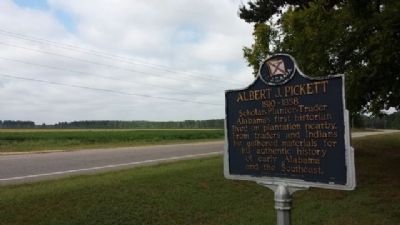
On Alabama Route 14 at County Road 133, on the right when traveling west on Alabama Route 14. Reported permanently removed.
Alabama's first historian lived on plantation nearby. From traders and Indians he gathered materials for his authentic history of early Alabama and the Southeast. — — Map (db m304048) HM
On Alabama 14 at County Road 133, on the left when traveling east on Alabama 14.
Born August 13, 1810 in Anson County, North Carolina. Albert
James Pickett was the youngest child of Colonel William Raiford
Pickett and Frances Dickson. The family moved to the Alabama
Territory in 1818, establishing a plantation and lucrative . . . — — Map (db m304050) HM
On South Autauga Street at Academy Street, on the right when traveling south on South Autauga Street.
Robert Ripley's world-wide syndicated Believe It Or Not! column for July 31, 1935 read: "C. D. Abbott is the first citizen of the U.S.A. He is first alphabetically in Autaugaville, the first town in Autauga, the first county in Alabama, the . . . — — Map (db m68839) HM
On County Road 9 S 0.2 miles north of State Route 14, on the left when traveling north.
Dating to the Reconstruction Era, Greater Mallard's Chapel
A.M.E. Church Cemetery has 151 marked graves and many
unmarked graves. Associated with Greater Mallard's Chapel
A.M.E. Church, which purchased the church building and
property in 1885 . . . — — Map (db m294227) HM
On County Road 78 0.8 miles west of State Highway 14, on the left when traveling west.
The Taylor Family Cemetery and surrounding brick wall date to the mid-1820s. The wall contains bricks hand-made in Autauga County with Alabama red clay. The family of Benjamin Taylor, Sr., (1761-1836) started the cemetery. Benjamin married . . . — — Map (db m306057) HM
On County Road 45N 0.5 miles north of County Road 44, on the right when traveling north.
Old Harmony Cemetery is the final resting place of some of Western Autauga County's earliest settlers. The cemetery includes burials of members of both Harmony Baptist Church and Caver's Methodist Protestant Church. Harmony Baptist Church was . . . — — Map (db m267938) HM
Near County Road 165 at Hilltop Farm Road, on the left when traveling south.
Established prior to 1833, the Robinson-DeJarnette Cemetery is located
on property first granted by the U. S. Government to early Autauga County
settler James Jackson. In 1825, Jackson transferred the land patent to
Eli Terry Sr. On March 16, . . . — — Map (db m294231) HM
On County Road 3 1.9 miles south of U.S. 82, on the left when traveling south.
The William Dixon Smith family settled in Autauga County in 1818, prior to Alabama Statehood. The family patriarch, William Dixon Smith (1809-1902), was a planter, forester, and operated a sawmill and gin. He also operated a mercantile business . . . — — Map (db m304169) HM
On County Road 79 0.6 miles south of County Road 72, on the left when traveling north.
The James Jackson Cemetery is the final resting place of James Jackson,
one of the earliest White settlers in old Autauga County. He settled in the
area in 1817, when Alabama was still a territory. He established a large
plantation, Auburn Hill, . . . — — Map (db m303972) HM
Near County Road 63 0.3 miles south of County Road 530, on the right when traveling south.
By 1900, America's forests were in a depleted
state. In the 1920's and 30's, conservationist
and lumberman Evan Frank Allison led the
movement to revitalize Alabama's forests and
wildlife. At one time he and his forester
counted less than five . . . — — Map (db m207007) HM
Near County Road 63 0.3 miles south of County Road 530, on the right when traveling south.
When the Soldiers' Home opened, veterans
cooked for themselves in their cottages. Later,
cooks were hired, serving meals in one
cottage of each row. Around 1920, the Mess
Hall was constructed, providing the most
efficient method of serving . . . — — Map (db m206693) HM
On County Road 99 north of County Road 68W, on the right when traveling north.
Located on the site of the Old Myrick Plantation, George Myrick established this cemetery. He arrived in Autauga County in 1826 and he built his home just north of this site. The original chapel dates to the 1870s and served as a local school as . . . — — Map (db m206686) HM
Near County Road 63 0.2 miles south of County Road 530, on the right when traveling south.
The individual cottages at the Alabama
Confederate Soldiers' Home contrasted
with the large barracks found at many
other Civil War veterans homes across
the country during the early 1900's.
All nine cottages of the Soldiers' Home
had . . . — — Map (db m206689) HM
Near County Road 63 0.3 miles south of County Road 530, on the right when traveling south.
The individual cottages at the Alabama
Confederate Soldiers' Home contrasted
with the large barracks found at many
other Civil War veterans homes across
the country during the early 1900's. The
cottages in this row were paid for by
private . . . — — Map (db m206798) HM
Near County Road 63 0.2 miles south of County Road 530, on the right when traveling south.
Erected on this site in 1904 by the
State of Alabama, the Hospital was
constructed to meet what was
described as the "pressing need" for
medical care of the veterans at the
Confederate Soldiers' Home. This
25-bed facility was said to . . . — — Map (db m206691) HM
On Autauga County Road 1, on the right when traveling north.
Milton was settled around 1829. By 1840 it had become a prominent village of Autauga County. It was known as "Milton City” when the 1886 flood buried it in sand. Among the early families were Wm. L. and Sarah Taylor. Elihu and Elizabeth Parr Bates. . . . — — Map (db m209092) HM
On Alabama Route 14 0.4 miles west of County Road 9, on the right when traveling west.
Constructed in 1854, Ivy Creek Methodist Church originally was part of the Mulberry Beat in Autagua County. The church served the communities of Hamilton, Huckabee (Evergreen), Milton, Statesville-Mulberry, and West Autaugaville. Ivy Creek Methodist . . . — — Map (db m158666) HM
On East 4th Street west of North Court Street, on the right when traveling west.
Created in 1818 by an act of Alabama Territorial Legislature. Autauga Indians lived on creek from which the county takes its name. Autaugas were members of the Alibamo tribe. They sent many warriors to resist Andrew Jackson's invasion in Creek War. . . . — — Map (db m27907) HM
On Maple Street 0.2 miles west of Selma Highway, on the right when traveling north.
Alabama takes its name from this tribe,
whose settlements were located along the
headwaters of the Alabama River. Early French
colonists called them Alibamons, and engaged
the tribe in trade at nearby Fort Toulouse.
When the French . . . — — Map (db m294212) HM
Near West Main Street 0.1 miles west of South Chestnut Street, on the right when traveling east.
Side 1
Water has always played a significant role in the history of Prattville. Daniel Pratt chose the location for his new town because of the proximity to Autauga Creek and the Alabama River. This area was referred to as an . . . — — Map (db m70815) HM
On County Road 4 0.1 miles west of Buena Vista Boulevard, on the right when traveling west.
This antebellum plantation house was completed by Capt. William Montgomery, a contemporary of Prattville's founder, Daniel Pratt.
This “Deep South” architecture reflects the Federal style with the later addition of a Colonial Revival facade . . . — — Map (db m294722) HM
On East 4th Street at South Chestnut Street, on the right when traveling east on East 4th Street.
Side 1
Daniel Pratt
Founder of Prattville
Daniel Pratt, a native of New Hampshire, became an industrialist, statesman and philanthropist in Alabama. He was a Methodist in both heart and practice. He encourage the development of the . . . — — Map (db m70813) HM
Daniel Pratt CemeteryFinal resting place of early Alabama industrialist Daniel Pratt, 1799-1873, and wife Esther Ticknor Pratt, 1803-1875. He was from New Hampshire and she, Connecticut. Married 1827 at Fortville, Jones County, Georgia. . . . — — Map (db m168941) HM
On Doster Road at Mobile Drive, on the right when traveling south on Doster Road.
Prattville is often referred to as “The Fountain City” for the numerous free-flowing artesian wells found here. A 1933 edition of the Prattville Progress noted that there were more than 400 of these artesian wells in Prattville . . . — — Map (db m70805) HM
On 7th Street at N Court Street, on the right when traveling west on 7th Street.
First Missionary Baptist Church was originally constructed across Autauga
Creek in the 1850s as a white Presbyterian church. That congregation
gifted the building to the Black congregation several decades later.
For over a century, the First . . . — — Map (db m303955) HM
On East 3rd Street at South Chestnut Street, on the right when traveling east on East 3rd Street.
Side 1
First Presbyterian Church of Prattville, Alabama
Organized 1846 by Pastor Wm. H. Mitchell, this congregation succeeded Millenium Hope Presbyterian, 2 mi. E. of town. Pastor Jas. K. Hazen (1861-77) married Mary Ticknor, . . . — — Map (db m81479) HM
On East Sixth Street 0.4 miles east of North Northington Street, on the right when traveling west.
Known as Fair Road, Sixth Street from Northington Street to the big curve was called “Happy Hollow”. The road went to the Fair home place but also curved right, into Warren Circle. Here stood a small frame church where the congregation’s . . . — — Map (db m70800) HM
On South Court Street at West Main Street, on the right when traveling south on South Court Street.
Located within Daniel Pratt Historic District, this park overlooks Autauga Creek and the manufacturing complex around which this New England style village developed. Daniel Pratt founded Prattville in 1839, and patterned the town after those of his . . . — — Map (db m27958) HM
On Dosterville Road 1.5 miles west of South Memorial Drive (U.S. 31), on the left when traveling west.
Indian Springs Post Office
Location of considerable Community activity in the early nineteenth-century Autauga County
Thomas Hill House
Site of first Court after Autauga became a County
Union Baptist Meeting House
1830s . . . — — Map (db m70798) HM
On County Road 57 just north of County Road 6, on the right when traveling north.
In 1919, Anthony Townsend donated 5 acres of land for this school. In 1913, Julius Rosenwald, CEO of Sears & Roebuck, and Booker T. Washington established the Rosenwald School program to improve the quality of public education for African American . . . — — Map (db m158654) HM
On Main Steet at South Chestnut Sreet, on the right when traveling east on Main Steet.
Built circa, 1840s by A.K. McWilliams, this story and one-half Federal-style raised cottage with Greek Revival elements was the residence of Amos Smith, who named the town of Prattville.
The west front parlor was the meeting place where the . . . — — Map (db m27982) HM
On Martin Luther King Drive north of Cone Street, on the right when traveling north.
In 1957, the Citizens Community Improvement Club, represented by Willie Lee
Wood Sr., Mary E. Averhart, Lewis Douglas, and Isom Jones, successfully
lobbied the City of Prattville to designate a vacant 1.5-acre lot as a new
park for African . . . — — Map (db m294217) HM
On South Court Street at West 3rd Street, on the left when traveling south on South Court Street.
The county's third courthouse was used until 1906. George Littlefield Smith, an early citizen of Prattville, designed and built the Italianate-style structure. Earlier county seats were Washington, then Kingston.
Marker placed by the . . . — — Map (db m70808) HM
On County Road 21 0.1 miles south of County Road 40, on the left when traveling south.
This cemetery is one of the oldest cemeteries in Autauga County having been established as a burial ground by at least 1841. The land was officially set aside as a burial ground when the county seat was in this area from 1834 to 1868. The area . . . — — Map (db m82561) HM
On Maple Street at Pletcher Street, on the right when traveling west on Maple Street.
The plank road was constructed of large pine logs, sawed lengthwise and laid round-side down. Daniel Pratt built the road for public benefit and to provide transportation from the Pratt Cotton Gin Factory to Washington on the Alabama River. Over . . . — — Map (db m27983) HM
On East Main Street at South Memorial Drive (U.S. 31), on the right when traveling east on East Main Street.
Once the world's largest plant manufacturing cotton gins.
Founded 1833 by Daniel Pratt, the greatest industrialist of Alabama prior to 1860. Pratt's many industries were of great aid to Confederacy during Northern blockade. — — Map (db m70799) HM
On Bridge Street at Gin Shop Hill Road, on the right when traveling west on Bridge Street.
Daniel Pratt, Prattville’s founding father, constructed an imposing home and garden within a quarter-mile of this site on Autauga Creek, near his industrial complex. The large home was designed and erected by Pratt himself, a noted architect / . . . — — Map (db m27985) HM
On South Washington Street at East 4th Street, on the right when traveling north on South Washington Street.
On this memorial are engraved the names of the 100 original officers and men of the Prattville Dragoons. Their dedication to their families, their homes and their county is remembered and honored by their descendants.
Officers
Jessie . . . — — Map (db m129581) WM
On Rocky Mount Road 1.1 miles north of Cobbs Ford Road (U.S. 82), on the right when traveling north.
Rocky Mount Cemetery was established on this sacred ground for families who settled Cobb’s Ford and the surrounding area. The oldest marked burials date to the 1890s. Numerous veterans of the Civil War and World Wars I and II are buried here. Rocky . . . — — Map (db m158661) HM
On East 4th Street at South Washington Street, on the right when traveling east on East 4th Street.
Saint Mark's was organized in 1859 as a mission of the Diocese of Alabama. Services were first held at the Presbyterian Church and in the old Court House. In December 1876, the congregation purchased an old wooden frame chapel from the Methodists . . . — — Map (db m70801) HM
On Upper Kingston Road at Hadnott Way, on the right when traveling north on Upper Kingston Road.
Sallie Mae Hadnott was a leading civil rights activist in Autauga
County During the 1960s and 1970s, at great personal risk,
Hadnott helped found and lead several organizations dedicated
to improving the lives of African American citizens and . . . — — Map (db m294216) HM
Near Wetumpka Street at South Washington Street, on the right when traveling east.
Beloved teacher of Prattville Academy
1867 • on this site • 1868
whose memory will be forever
cherished by people of Prattville, Ala.
whom he loved and served — — Map (db m70820) HM
On Wetumpka Street (County Route 2) at South Washington Street, on the right when traveling east on Wetumpka Street.
Side 1
Sidney Lanier
1842-1881
The poet and musician, born in Macon, Georgia, was Academy principal in 1867-68. He married Mary H. Day of Macon in December 1867. In Prattville, they lived at the Mims Hotel and later in Dr. S.P. . . . — — Map (db m70802) HM
Near South Washington Street at East 4th Street, on the left when traveling south.
This boulder erected by
The Merrill E. Pratt Chapter U.D.C.
April 26, 1916,
marks the spot where
The Prattville Dragoons
assembled in April, 1861,
on the eve of their departure
to the war,
and is commemorative of their . . . — — Map (db m70819) HM WM
On South Chestnut Street at 1st Street, on the right when traveling south on South Chestnut Street.
A native of Prattville, Wilson Pickett was raised singing gospel in local churches. Upon moving to Detroit as a teenager, he began to blend gospel-style with rhythm and blues, resulting in some of "the deepest, funkiest soul music" to come from the . . . — — Map (db m70804) HM
On County Road 22 0.3 miles east of County Road 130, on the left when traveling north.
The Vine Hill Cemetery was established in the 1880s. The cemetery sits atop
a ridge in western Autauga County and has over 100 marked graves. The
oldest is for Kate Elizabeth Sherrill, who died in 1890. The cemetery
is the final resting place . . . — — Map (db m304120) HM
On County Road 21 south of County Road 20, on the right when traveling south.
In 1870, Marbury Lumber Company donated land for the White Pond Methodist Church and Cemetery. It is believed that the first burial in the cemetery, marked only by a pile of bricks, took place that same year. The earliest marked grave is of Thomas . . . — — Map (db m158662) HM
On County Road 3 0.7 miles east of Greeno Road (U.S. 98), on the right when traveling east.
Barnwell
In 1903, Postmaster Charles 'Dewey' Slocum designated the community
post office 'Barnwell' in honor of Rev. Robert Woodward Barnwell, an
Alabama Episcopal Bishop. It first operated out of the Slocum home and
later from the Basil . . . — — Map (db m207535) HM
On Courthouse Square (U.S. 31) at Hand Avenue, on the left when traveling east on Courthouse Square.
Third oldest county in Alabama.
Created in 1809 while still part
of Mississippi Territory.
Named for Abraham Baldwin (1754-1807)
founder of University of Georgia,
delegate to Constitutional Convention,
member of Congress, 1789-1807. . . . — — Map (db m100839) HM
On Hall Avenue (U.S. 31) at D'Olive Street on Hall Avenue.
Battery B
711th AAA Gun Battalion
Alabama National Guard
Bay Minette, Alabama
[List of names in 3 columns]
4 September 1950
Korean War — — Map (db m100941) WM
On West 2nd Street east of McMillan Avenue, on the right when traveling east.
Side 1
In 1860, the center of commerce in Baldwin County ran along the rivers with the remainder of the county mostly wilderness. In 1861, with secession declared, the Alabama Legislature allocated funds to finish the stalled Mobile . . . — — Map (db m100846) HM
On Courthouse Square (U.S. 31) at Hand Avenue, on the left when traveling east on Courthouse Square.
Bottle Creek Site has been designated a National Historic Landmark. This site possesses national significance in commemorating the history of the United States of America. — — Map (db m100849) HM
On Courthouse Square (U.S. 31) at Hand Avenue, on the left when traveling west on Courthouse Square.
Born and educated in England, Toulmin became a Unitarian Minister and fled persecution in 1793. In the U.S. he served as President of Transylvania University and Secretary of the State of Kentucky. In 1804 Thomas Jefferson appointed him as the first . . . — — Map (db m100850) HM
On Courthouse Square at U.S. 31, on the left when traveling north on Courthouse Square.
Lynching in America
Between 1865 and 1950, at least 6,500 African Americans were victims
of lynch mob violence in the United States. After the Civil War, an
ongoing commitment to white supremacy led to organized resistance to
Black . . . — — Map (db m207065) HM
On Shedrick Hardy Parkway 0.1 miles south of Rain Drive, on the right when traveling south.
Stephen J. Boykin was born in an unincorporated area in Wilcox County, Alabama around 1859. He was a self-educated man and worked early in his life as a laborer at a lumber mill. He married Carrie Taylor in 1906 and they raised eight children.
Mr. . . . — — Map (db m234961) HM
On Washington Avenue south of Old Blakeley Road, on the right when traveling south.
(front)
In memory of the Alabama
Confederate States of America
Soldiers Sailors
who served at Fort Blakeley
Dedicated by
Mobile Bay District
United Daughters of the Confederacy
2010
(back)
Chapters
Bonnie . . . — — Map (db m87295) WM
Near Battlefield Road 0.3 miles east of Green Street, on the right when traveling east.
Fort Blakeley, named for the town which it surrounded, was one of two major Confederate defensive positions protecting eastern approaches to Mobile during the Civil War. The fort consisted of a nearly three mile long series of entrenchments anchored . . . — — Map (db m131891) HM
On Old Blakeley Road, on the right when traveling south.
Artillery and musketry swept them in the face, and sand-bombs burst from under their feet. At last the ditch was reached...the garrison's infantry poured a galling fire from the loop-holes, and the heavy siege guns rained grape(shot) from the . . . — — Map (db m131865) HM
On Franklin Street, on the right when traveling north. Reported permanently removed.
Ruins of the original Foundation of
Baldwin County's First Courthouse
Authorized 1820 • Constructed circa 1833
Preserved by Historic Blakely State Park 2011-12
With support in part of a Save Amerca's Treasures grant by the National Park . . . — — Map (db m82019) HM
On Franklin Street north of Washington Avenue, on the right when traveling north.
This foundation is all that remains of Baldwin County’s first courthouse.
Authorized in 1820 but not constructed until circa 1833, the two-story brick building contained a jail on the bottom floor with office space on the upper floor. . . . — — Map (db m131830) HM
On Franklin Street 0.4 miles north of Washington Avenue, on the right when traveling west.
Just a half century prior to the founding of the town of Blakeley, an Apalachee Indian village stood on this spot. The village was founded in the early 1700s by Apalachee refugees fleeing warfare in Florida for the relative safety of French . . . — — Map (db m131851) HM
On Battlefield Road 0.3 miles east of Green Street.
You are standing on the site of the last grand charge of the Civil War, made during the Battle of Fort Blakeley on April 9. 1865. The battle was the climax of a months-long campaign that led ultimately to the capture of the city of Mobile by Union . . . — — Map (db m131890) HM
On Battlefield Road 0.8 miles east of Green Street, on the right when traveling north.
The Battle of Fort Blakely April 9, 1865 was the last major battle of the Civil War. This 67 acre part of the Blakeley Battlefield was acquired in 2002 with assistance of grants from the Land & Water Conservation Fund administered by the National . . . — — Map (db m87296) HM
On Franklin Street 0.4 miles north of Washington Avenue, on the right when traveling west.
The Bottle Creek site is the second largest mound center in Alabama and it represents the remnants of a large Mississippian Stage civic and ceremonial complex that dominated the Mobile-Tensaw Delta from AD 1250 to 1500. Located in the heart of the . . . — — Map (db m131832) HM
On Battlefield Road, on the left when traveling east.
"Each man was provided with a spade, and at the given signal, the line advanced in good shape, though opposed by a sharp fire."
Brig. Gen. Christopher C. Andrews
The Union Army laid siege to Fort Blakeley for over a week prior to the . . . — — Map (db m131932) HM
On Franklin Street 0.1 miles north of Washington Avenue, on the left when traveling north.
Blakeley was once one of the largest cities in Alabama. Envisioned by its founders as a rival to Mobile as a regional trading center, the town thrived briefly before a combination of factors brought about its decline. Today the site of the city is . . . — — Map (db m131864) HM
On Battlefield Road, on the left when traveling east.
Greater gallantry than was shown by officers and men could hardly be desired. The (troops) were burning with an impulse to do honor to their race, and rushed forward with intense enthusiasm, in face of a terrible fire."
Brig. Gen. . . . — — Map (db m131903) HM
On Union Trail Loop west of Old Blakeley Road, on the left.
Though outnumbering Confederate troops at Blakeley better than four to one, the Union Army had decidedly less artillery than the fort's defenders: By the time of the final assault on the fort on April 9, 1865, about 20 guns were scattered along the . . . — — Map (db m131859) HM
On County Road 49 at Swift Coles Lane, on the left when traveling south on County Road 49.
The Charles Swift Family
Charles Swift came to Alabama in 1880 and married Susan Roberts in 1885. He developed a successful lumber business, including a sawmill here on the Bon Secour River. The Swifts raised their eleven children in this . . . — — Map (db m122465) HM
On River Road 0.2 miles west of Bon Secour Highway, on the left when traveling west.
Both people and animals need salt to remain healthy. Before the Civil War the people of Alabama consumed about 50 pounds of salt per person per year, most of which came from England and the West Indies. One quarter of all the salt imported into the . . . — — Map (db m68503) HM
On Main Street south of Bayfront Park Drive, on the right when traveling south.
Standing on a low limb of a giant oak tree near here, General Andrew Jackson made a pep talk to his troops, fresh from their victory at the Battle of Horse Shoe Bend and poised before advancing on the British and Spanish at Pensacola, and the . . . — — Map (db m100852) HM
On Main Street at Manci Avenue, on the right when traveling south on Main Street.
The City of Daphne was incorporated July 8, 1927 with a population of 500. its history, however, dates to a much earlier period. Research and artifacts show that Tensaw, Alabama, Choctaw, Creeks, and Seminole Indians all lived in the this area prior . . . — — Map (db m100843) HM
On Daphne Road (County Road 64) near State Route 181, on the right when traveling west.
Colonia Italiana 1888-The Beautiful Forest
In 1888, Alesandro Mastro-Valerio, realizing the plight of fellow Italian immigrants living and working in hazardous conditions in many northern states, bought land here to attract colonists. He . . . — — Map (db m130913) HM
This church and cemetery have been in continuous service by the citizens of this area since the 1840's. Originally named "Methodist Episcopal Church South." Land donated by William L. Howard. Building built by L. E. Edmondson and a Creole helper, . . . — — Map (db m49260) HM
On Patrician Drive W 0.1 miles north of Patrician Drive S, in the median.
George and Patrice Fuller from Illinois fell in love with the Southland. In spite of the 1930 economic depression, they acquired sufficient property to plan Spanish Fort Estates.
Their foresight also preserves evidence of the last stand of the . . . — — Map (db m170735) HM
On Main Street (County Road 98) at Magnolia Avenue, on the right when traveling north on Main Street.
On April 15, 1867, Major Lewis Starke deeded these two acres to four of his ex-slaves and their heirs as trustees for this church: Nimrod Lovett, Stamford Starlin (now Sterling), Narcis Elwa, and Benjamin Franklin.
In this cemetery is buried . . . — — Map (db m100851) HM
Patriot's Point Memorial
This Memorial is Dedicated to All the
Brave Men and Women Who Proudly
Served in the United States Armed Forces
Protecting Freedom Around the World — — Map (db m100864) WM
The Eastern Shore Trail is a 24-mile pedestrian/bike trail from US Hwy 98 at Gator Alley in Daphne to Weeks Bay on Scenic Hwy 98. Teko Wiseman, founder of the Baldwin County Trailblazers-the organization responsible for the trail's . . . — — Map (db m128881)
By the 1750s, French colonists were living on family farms on the shores of Mobile Bay. One group of settlements, known as ‘The Village', was located here along on the bluffs of the eastern shore of the bay. The colonists raised cattle, pigs, and . . . — — Map (db m291606) HM
On U.S. 98 north of Whispering Pines Road, on the right when traveling north.
Yancey Crane Cemetery is one of the earliest known cemeteries in Daphne, which was formerly known as the Village. Historical records indicate burials date from 1860 or earlier. Early settlers, Civil War and WWI soldiers, former enslaved persons, and . . . — — Map (db m291861) HM
On U.S. 90 at Thelma Burke Road/Poplar Road, on the right when traveling west on U.S. 90.
This countryside along what is called the “Old Spanish Trail” between Mobile Bay and Pensacola was only sparsely settled in the early 1900’s. In 1909, F. X. Duchesneau and other French Canadians from North Dakota moved here to . . . — — Map (db m285990) HM
On Scenic Highway 98 (Alternate U.S. 98) near Zundel Road, on the right when traveling south.
The Baldwin County Historic Development Commission was petitioned on October 15, 2012, for Historic Site Designation, pursuant to the authority conveyed by the Act No. 80-497, as amended by Act No. 89-960, and during their October 21, 2012 meeting, . . . — — Map (db m154449) HM
On North Section Street north of Fairhope Ave, on the right when traveling north.
Fairhope began as the dream of a group of individuals who were
seeking their own utopia. The first Single-Tax colonists (so called
because of their belief in the economic theories of Henry George,
who advocated no taxes other than a single land . . . — — Map (db m284081) HM
On Pine Grove Drive near Confederate Rest Road, on the right when traveling west.
The Grand Hotel and the Gunnison House served as a hospital for wounded Confederate soldiers from the Battle of Vicksburg during the Civil War. The Confederate Rest Cemetery commemorates more than 300 Confederate soldiers who died while in the . . . — — Map (db m153433) HM
Master woodcarver, adventurer, writer, World War II Marine Corps veteran, and Fairhope legend are just a brief summary of Craig Turner Sheldon's life and contributions. He settled here in 1946 with his Wife Annie Lowrie to raise their growing family . . . — — Map (db m128894)
On Oak Avenue at N Church Street, on the right when traveling west on Oak Avenue.
The founding fathers of the Fairhope Single Tax Corporation recognized a need and established the Fairhope Colony Cemetery circa 1895. A beautiful site, situated on the corner of Oak Avenue and Section Street in the City of Fairhope, was selected . . . — — Map (db m291860) HM
On 24 N Section Street at Fairhope Avenue, on the right when traveling north on 24 N Section Street.
Dedicated 2008
A gift to the people of Fairhope from
The Fairhope Single Tax Corporation
& the City of Fairhope
Dedicated April 5, 2008
The Front Section of this structure was carefully restored to reflect its original
use as Fairhope's . . . — — Map (db m128887) HM
Land
“The Source of all wealth”
Henry George 1839-1897
Taxes applied to the source are an inducement to use the land wisely
These parks donated by
Fairhope Single Tax Corporation September 29, 1931
Capital
“The . . . — — Map (db m128893) HM
Marietta Johnson, world leader of the Progressive Education Movement founded the School of Organic Education in 1907. The school, which demonstrated her philosophy, attracted intellectuals and artists. Her work is a reminder of Fairhope’s . . . — — Map (db m128888) HM
On South Bancroft Street, on the left when traveling south on South Bancroft Street.
At the end of the Civil War, former slaves John
Lewis (1838-1891) and his wife Nancy Lewis (1841-1910)
enjoyed newly found freedom and moved here to
southwest Baldwin County, Alabama.
The Lewis' lived on unused land and had an . . . — — Map (db m285537) HM
Honoring all Veterans and Their Families
Concept Designer:Sissy Birindelli
Sculptor: Stephen Spears
The Fairhope Veterans Memorial Committee
Wishes to thank all our supporters, with special thanks to :
The City of Fairhope
The Single . . . — — Map (db m128892) WM
The first Fairhope pier was built in 1895. In the early years, the wooden pier served as a commercial dock for the bay boats. The first concrete pier was built in 1968 and remained in use until being severely damaged by Hurricane Ivan in 2004 and . . . — — Map (db m128891) HM
On Eastern Shore Trail south of Taylor Street, on the left when traveling north.
Near here at junction of Rock Creek and Mobile Bay lies Ecor Rouge, highest coastline point between Maine and Mexico. Aboriginal Indians held powwows and made pottery here. The red cliff, a mariners' landmark on Spanish maps of 1500's, called Ecor . . . — — Map (db m257464) HM
4624 entries matched your criteria. The first 100 are listed above. Next 100 ⊳