On Wilkinson Street, on the right when traveling south.
Liberty Hall A National Historic Landmark This Georgian mansion was begun 1796, by John Brown and named for Lexington, Virginia academy he attended. His wife Margaretta and Elizabeth Love began first Sunday School west of Alleghenies in . . . — — Map (db m84387) HM
On Charlie Downing Road north of Bragg Avenue, on the right when traveling north.
Thomas Woodson received this farm as a land grant from Thomas Jefferson for service in the Revolutionary War. His son Anthony made his home on this site and developed a prosperous farmstead, considered one of the finest in the county. From his front . . . — — Map (db m40033) HM
On W Jefferson Street at S 5th Street, on the right when traveling west on W Jefferson Street.
City and County Named. Louisville, at the Falls of the Ohio, was founded in 1778 by George Rogers Clark. Site first served as a military outpost; the city which developed was named for Louis XVI. Kentucky Co., Virginia, was divided in 1780 . . . — — Map (db m104581) HM
On West Jefferson Street near South 5th Street, on the right when traveling west.
One of three original counties formed when Kentucky Co., Virginia, was divided by Va. Act in 1780. Other 2 counties were Lincoln and Fayette. Jefferson included 19 present-day counties; parts of 11 others. By 1811 reduced to present boundaries. . . . — — Map (db m205257) HM
On W Jefferson Street near S 5th Street, on the right when traveling west.
( inscribed around the base )
This monument to Thomas Jefferson was presented to the people of Kentucky July 4 1900 by Isaac W and Bernard Bernheim to perpetuate the teachings and examples of the Founders of the Republic
( . . . — — Map (db m104579) HM
On Court Street (State Highway 453) 0.1 miles east of Adair Street (U.S. 60), on the right when traveling east.
For Robert R. Livingston, 1746-1813 N.Y. provincial convention 1775; Continental Congress 1775-77, 1779-81; one of the committee to draft the Declaration of Independence. Sec. of Foreign Affairs, 1781-83. Administered oath to Washington, first . . . — — Map (db m159390) HM
On Main Street north of Shelby Street, on the right when traveling north.
The Kennett Tavern is the oldest commercial building remaining in the State of Kentucky reflecting a Federal/Georgian style architecture. Built along the Old Revolutionary War Road during the Thomas Jefferson Administration-this tavern/hotel housed . . . — — Map (db m67670) HM
Near South Irma Boulevard, 0.3 miles north of East Worthey Street, on the right when traveling north.
Three Louisiana men played prominent roles in the Mexican-American War. Though John Slidell was born in New York, he moved to New Orleans in 1819, started a successful law practice, and eventually became an important leader of the Democratic Party . . . — — Map (db m114832) HM
On U.S. 90 west of West Bank Expressway (Business U.S. 90), on the right when traveling east.
On Feb. 11, 1825, Governor Henry S. Johnson signed legislation creating the Parish of Jefferson out of the Third Senatorial District. It is named for President Thomas Jefferson, who died the following year, July 4. — — Map (db m148816) HM
On State Highway 1 east of Land Fill Lane, on the right when traveling east.
On Feb. 11, 1825, Governor Henry S. Johnson signed legislation creating the Parish of Jefferson out of the Third Senatorial District. It is named for President Thomas Jefferson, who died the following year, July 4. — — Map (db m100007) HM
On Feb. 11, 1825, Governor Henry S. Johnson signed legislation creating the Parish of Jefferson out of the Third Senatorial District. It is named for President Thomas Jefferson, who died the following year, July 4. — — Map (db m112786) HM
On Belle Chasse Highway (State Highway 23) 0.1 miles north of Lapalco Boulevard (State Highway 428), in the median.
On Feb. 11, 1825, Governor Henry S. Johnson signed legislation creating the Parish of Jefferson out of the Third Senatorial District. It is named for President Thomas Jefferson, who died the following year, July 4. — — Map (db m81065) HM
On Jefferson Street (State Highway 6) at Keyser Avenue (State Highway 494), on the right when traveling north on Jefferson Street.
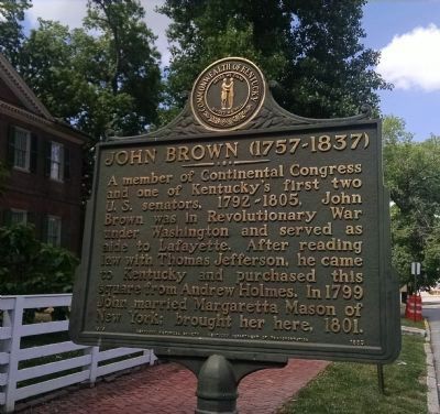
Born May 19th, 1757
Sutton, Massachusetts
Died April 8th, 1837
Natchitoches, Louisiana
In 1776, at age 19, John Sibley served the patriot cause in the American Revolution as a surgeon’s mate with the Massachusetts Militia. In 1784, he . . . — — Map (db m106168) HM
Near 2nd Street at Bossier Street, on the right when traveling north.
Established in 1737, the American Cemetery is considered one of the oldest cemeteries in the Louisiana Purchase. The many civic, religious, military, and political leaders buried here reflect the long and colorful history of Cane River National . . . — — Map (db m106111) HM
On 2nd Street at Sibley Street, on the left when traveling north on 2nd Street.
President Thomas Jefferson negotiated the Louisiana Purchase with French Emperor Napoleon Bonaparte in 1803. The Louisiana Purchase was the largest peacetime land acquisition in U.S. history, containing territory that eventually comprised 15 states. . . . — — Map (db m106110) HM
Near Court Street (County Route 987-4) at Route 987-5.
(panel 1)
Life in Early Nineteenth Century West Baton Rouge…
In 1803, very few Americans lived in West Baton Rouge Parish. It was populated by various Native American tribes; Creoles, who descended from original French and . . . — — Map (db m89070) HM
On Greene Street at Bridge Street on Greene Street.
You are standing at the starting point of this country's first federal road building project, the National Road. A vision of George Washington as a means to develop the continent and to unite the country, his idea was championed by Thomas . . . — — Map (db m17716) HM
On Prince George Street west of Craig Street, on the right when traveling west.
February 22, 1797: At the Presidential Mansion in Philadelphia, President George Washington formally presented Irish-born John Barry with Commission Number One in the newly formed United States Navy. With the commission, backdated to the . . . — — Map (db m114812) HM
On West Street at Church Circle, on the right when traveling west on West Street.
During winter 1988/89, the area known as Lot 70 in James Stoddert’s 1718 survey will be the site of a historical archeological excavation.
In 1718, this lot was owned by Charles Carroll, grandfather of Charles Carroll of Carrollton, who in 1734 . . . — — Map (db m2860) HM
On Conduit Street near Gorman Street, on the left when traveling south.
Just north of this building, facing Main Street, stood Mann’s Tavern where twelve delegates from five states met in 1786 to discuss commercial problems of the new nation. Their call for another convention in Philadelphia to render the government . . . — — Map (db m130220) HM
In this state house, oldest in the nation still in legislative use, General George Washington resigned his commission before the Continental Congress December 23, 1783. Here, January 14, 1784, Congress ratified the Treaty of Paris to end the . . . — — Map (db m2864) HM
On State Circle at Francis Street on State Circle.
In this state house, oldest in the nation still in legislative use, General George Washington resigned his commission before the Continental Congress December 23, 1783. Here, January 14, 1784, Congress ratified the Treaty of Paris to end the . . . — — Map (db m6703) HM
The oldest military monument in the United States honors heroes of the War against the Barbary Coast Pirates, the new republic's first war. In 1804, President Jefferson ordered the nation's tiny naval force to the Mediterranean to protect the . . . — — Map (db m100660) HM
The self-educated Negro mathematician and astronomer was born, lived his entire life and died near here.
He assisted in surveying the District of Columbia, 1791, and published the first Maryland Almanac, 1792. Thomas Jefferson recognized his . . . — — Map (db m160718) HM
On Frederick Road (Maryland Route 144) at Oella Avenue, on the right when traveling west on Frederick Road.
The Ellicott brothers constructed what became the first leg of the Baltimore and Frederick-Town Turnpike to get their flour to market in Baltimore. By 1787, they cut a new road east through the forests to shorten the trip to the city. This route . . . — — Map (db m128248) HM
On Pine Street just north of Cedar Street, on the right when traveling north.
In the first half of the 20th century, Pine Street in Cambridge pulsed to the music of the world's greatest jazz and blues musicians. The neighborhood was then a stop on the "Chitlin' Circuit," the network of nightclubs and theaters traveled by . . . — — Map (db m138282) HM
On Park Mills Road at Urbana Pike (Maryland Route 355), on the right when traveling east on Park Mills Road.
First glass manufactury in Maryland. Established by John Frederick Amelung of Bremen, Germany in 1784. George Washington wrote enthusiastically about it to Thomas Jefferson. — — Map (db m117294) HM
Near Visitors Center Drive at Garrett Highway (U.S. 219), on the left when traveling west. Reported permanently removed.
“. . . so many happy people, restless in the midst of abundance.” —Alexis de Tocqueville, 1840.
Americans are an adventurous people. From
past to present, they have used feet, horses,
wagons, stagecoaches, canals, . . . — — Map (db m2171) HM
On High Street, 0.2 miles north of Cannon Street, on the left when traveling north.
The Chestertown waterfront seems quiet today, but it was a flashpoint in the American colonists' struggle for liberty.
Kent County, long loyal to England, found its ancestral ties weakening with each new generation born on American soil. . . . — — Map (db m138241) HM
On Western Avenue east of Park Avenue, on the right when traveling west.
In 1790, Congress authorized the establishment of a territory 10 miles square on the Potomac River to be the Capital of the United States. It was President Washington's recommendation to use land on both sides of the river. Surveyor Andrew Ellicott, . . . — — Map (db m154770) HM
On Market Street east of South Street, on the right when traveling east.
The Briggs House was built in 1803 for Hannah Brooke Briggs and her husband Isaac Briggs, who were still living here in 1814. The Briggses also owned a house and farm known as Sharon in Sandy Spring. Hannah, a devout Quaker, married Isaac Briggs in . . . — — Map (db m128850) HM
Near Rockville Pike (Maryland Route 355) south of Executive Boulevard, on the left when traveling north.
The following is a list of the translations, transcriptions, and sources for the texts on the screen
John Smith 1612 AD "There is but one entrance by sea into this country, and that is at the mouth of a very goodly bay, 18 or 20 miles . . . — — Map (db m113848) HM
On Bell Station Road, 0.1 miles west of Glenn Dale Boulevard (Maryland Route 193), on the left when traveling west.
Judge Gabriel Duvall built Marietta in 1812-13 and in the 1830s added a two-story wing on the north side. Duvall was distinguished for a lifetime of public service which included election to the Maryland state legislature and the United States . . . — — Map (db m3630) HM
On Toledo Road just west of America Boulevard, on the left when traveling west.
The Declaration of Independence
On June 7, 1776, forty-four-year-old Richard Henry Lee, Senior Member of the Virginia Delegation, submitted a resolution to the Continental Congress:
Resolved, that these United Colonies . . . — — Map (db m145903) HM
On Toledo Road just west of America Boulevard, on the left when traveling west.
The Lewis & Clark Expedition
In the Spring of America's 28th year, Captains Meriwether Lewis and William Clark began a vital mission, having been charged by President Thomas Jefferson to do three things: chart an all-water route from the . . . — — Map (db m145919) HM
The Louisiana Purchase
Under the direction of President Thomas Jefferson, the Louisiana Purchase of 1803 — the largest single land deal in the history of the United States — doubled the size of the young nation. Napolean Bonaparte of . . . — — Map (db m202672) HM
On Broadway just west of Commerce Street (Maryland Route 213), on the left when traveling west.
The Queen Anne's County Courthouse was constructed at the time when the county seat was removed from Queenstown to Centreville. It was accepted by the County Court on June 1, 1796, and ordered to be "taken, held and deemed to be the proper Court . . . — — Map (db m138253) HM
On Old National Road (Alternate U.S. 40) at Washington Monument Road, on the right when traveling west on Old National Road.
Native of Frederick County, skilled hunter and a superintendent of provisions with the Lewis and Clark expedition, John Collins was the first Marylander to cross the North American continent. Meriwether Lewis and William Clark were charged by Thomas . . . — — Map (db m1904) HM
On Old National Pike (Alternate U.S. 40) at Orchard Drive / Shafer Park Road, on the right when traveling east on Old National Pike.
“. . . so many happy people, restless in the midst of abundance.” —Alexis de Tocqueville, 1840.
Americans are an adventurous people. From
past to present, they have used feet, horses,
wagons, stagecoaches, canals, . . . — — Map (db m1911) HM
On the westbound Sideling Hill Visitors Center (Interstate 68 at milepost 75) near Exit 77 (Maryland Route 144), on the right when traveling west. Reported permanently removed.
“. . . so many happy people, restless in the midst of abundance.” —Alexis de Tocqueville, 1840.
Americans are an adventurous people. From
past to present, they have used feet, horses,
wagons, stagecoaches, canals, . . . — — Map (db m824) HM
On Church Street south of Main Street (Maryland Route 144), on the right when traveling north. Reported permanently removed.
“. . . so many happy people, restless in the midst of abundance.” —Alexis de Tocqueville, 1840.
Americans are an adventurous people. From
past to present, they have used feet, horses,
wagons, stagecoaches, canals, . . . — — Map (db m830) HM
On Broadway Street (State Highway 13) at 35th Street, on the right when traveling south on Broadway Street.
This boulder is erected
to the memory of
O-Ge-Ma Ke-Ga-To
Chief Speaker of the Chippewas
Born about 1794,; elected chief, 1815;
spoke at treaty, 1819; spoke before
Congress, 1837; died, 1840
First buried on property now known . . . — — Map (db m180642) HM
“Cass Cliff”
Named by the
Michigan Historical Commission
And
Mackinac Island State Park Commission
In honor of
Lewis Cass
Teacher – Lawyer – Explorer
Soldier – Diplomat . . . — — Map (db m107117) HM
On East Elm Street, 0.1 miles east of North Dixie Highway, on the left when traveling east.
Here in the log house of Jean Baptiste Jereaume the Federal Court of the Erie District, Territory of Michigan, held its first session July 3, 1805. President Thomas Jefferson named Judge Augustus B. Woodward to preside.
Beginning in 1807 the . . . — — Map (db m20909) HM
Near Natchez Trace Parkway (at milepost 8.7), 0.5 miles U.S. 61, on the right when traveling north. Reported missing.
(Marker #1)
A National Road
Natchez in the extreme south-western corner of the United States was threatened by Spain in 1800 and later by France and Great Britain.
President Jefferson in 1801 decided that a road from Nashville . . . — — Map (db m87267) HM
On Natchez Trace Parkway (at milepost 198.6), 3.1 miles north of Mississippi Highway 9, on the right when traveling north.
In the early 1800's many thoughtful Americans believed that isolation and the difficulties of communication would force the Mississippi Valley settlements to form a separate nation. Hoping to hold the frontier, Congress in 1800 established a post . . . — — Map (db m87483) HM
Missouri was a beginning and end for the Lewis and Clark Expedition. Planned by President Thomas Jefferson and carried out by the two captains and a large crew, the expedition is a keystone American event. When the United States took ownership of . . . — — Map (db m44590) HM
The land that would become Missouri and 14 other western states was acquired by the United States in the greatest land acquisition in American history: the Louisiana Purchase. By the stroke of a pen, President Thomas Jefferson ensured the country . . . — — Map (db m44615) HM
Joseph Robidoux, founder of St. Joseph, was the leader of a French-Canadian fur trading family which sent men out to trade with the Indians along the Missouri River and as far west as today's Wyoming, Colorado, and New Mexico. From his first trip . . . — — Map (db m91000) HM
St. Michael's Prairie
St. Michael’s Prairie, the site where St. Joseph would be established, was identified on maps at least as early as 1792. French explorers and trappers had been traveling up and down the Missouri River since the early . . . — — Map (db m47472) HM
In 1804-06, Captains Meriwether Lewis and William Clark led about 40 soldiers and boatmen on an epic journey. President Thomas Jefferson commissioned this "Corps of Discovery" to find a route to the Pacific Ocean through the newly acquired . . . — — Map (db m89212) HM
The Men of the Corps of Discovery
During the winter of 1803, Lewis and Clark set up camp opposite the mouth of the Missouri River. Here they drilled and trained their men to prepare them for the task ahead. All of the men had been selected . . . — — Map (db m79291) HM
On North Water Street south of Broadway Street, on the left when traveling south.
Between 1803 and 1806, Meriwether Lewis and William Clark led President Jefferson's Corps of Discovery to the great American West. On November 23, 1803, they stopped at Cape Girardeau to deliver letters of introduction to Louis Lorimier. Captain . . . — — Map (db m107721) HM
In 1803, President Thomas Jefferson buys the Louisiana Purchase from France for $15 million. It remains one of the greatest acquisitions in American history. In 1804, Jefferson sent Meriwether Lewis and William Clark to explore and map the . . . — — Map (db m68373) HM
On Water Street at Mill Street, on the left when traveling north on Water Street.
The Clay County Fine Arts Council commissioned this mural in commemoration of the 200th anniversary of the Lewis and Clark Corps of Discovery expedition.
The artist's version shows the expedition stopping at sundown to set camp along a bend in . . . — — Map (db m68309) HM
On Miller Street, on the left when traveling east on Miller Street.
In 1804-06, Captains Meriwether Lewis and William Clark led about 40 soldiers and boatmen on an epic journey. President Thomas Jefferson commissioned this "Corps of Discovery" to find a route to the Pacific Ocean through the newly acquired Louisiana . . . — — Map (db m121299) HM
This marker commemorates Robert Frazer, a member of the Corps of Discovery, on the occasion of the bicentennial of the Lewis and Clark Expedition.
Listed as a witness in the trial of United States vs. Robert Westcott, Frazer wrote to President . . . — — Map (db m61608) HM
On Jefferson Street, 0.1 miles north of 8th Street, on the right when traveling north.
Marker Front:
The French-speaking community made a significant contribution to the ultimate success of the epochal Lewis & Clark expedition. The St. Louis Chouteau brothers, fur traders Auguste and Pierre, lodged the two captains in their . . . — — Map (db m86207) HM
On West Thomas Drive at Old Bridge Street, on the left when traveling east on West Thomas Drive.
Sent out by Thomas Jefferson to explore the Great North West, spent three days near here making new oars for their boats June 17-18-19 • 1804 — — Map (db m131994) HM
On Main Street (U.S. 24) south of 2nd Street, on the left when traveling south.
James Monroe was born at Monroe's Creek, Westmoreland County, Virginia on April 28, 1758 to Scots-Welsh parents. He attended the College of William and Mary in Williamsburg, Virginia but left school to enlist in the Third Virginia Regiment, . . . — — Map (db m149767) HM
On Missouri Route 45/273 near the Iatan Power Plant Access Road, on the left when traveling north.
"Set out verry early this morning and proceeded on under a gentle Breeze from the S. passed two Islands one a Small Willow Island on the L.S. the other large Called by the french Isle de Vache or Cow Island, opposit the head of the S.S. is a large . . . — — Map (db m44567) HM
On Missouri Route 45/273 near the Iatan Power Plant Access Road, on the left when traveling north.
In 1804-06, Captains Meriwether Lewis and William Clark led about 40 soldiers and boatmen on an epic journey. President Thomas Jefferson commissioned this "Corps of Discovery" to find a route to the Pacific Ocean through the newly acquired . . . — — Map (db m44565) HM
In 1803, only a handful of states existed in America – the rest of the land was uncharted wilderness. That wilderness included the Louisiana Territory, which was purchased that year by the United States government.
At the same time, . . . — — Map (db m43233) HM
In 1804-06, Captains Meriwether Lewis and William Clark led about 40 soldiers and boatmen on an epic journey. President Thomas Jefferson commissioned this "Corps of Discovery" to find a route to the Pacific Ocean through the newly acquired . . . — — Map (db m44517) HM
On South Riverside Drive at Boone's Lick Road, on the left when traveling south on South Riverside Drive.
Corn (Zea mays), Pole Beans (Phaseolus vulgaris), Squash (Cucurbita maxima)
These three vegetables store very well during winter months and were important food sources for the Native Americans of the northern plains. . . . — — Map (db m169189) HM
On N Leonor K Sullivan Blvd. at Washington Ave., on the left when traveling south on N Leonor K Sullivan Blvd.. Reported missing.
The Return of the Lewis and Clark Expedition
Michael Haynes "We Arrived in Sight of St. Louis"
At about noon on September 23, 1806, five dugout canoes and a larger boat called the "White Pirogue" rounded the bend of the Mississippi River to . . . — — Map (db m151406) HM
On North Broadway at Olive Street, on the left when traveling south on North Broadway.
William Clark died in 1838 at his son's home on this site.
Clark became a national hero more than 30 years earlier when he and Meriwether Lewis explored the newly acquired Louisiana Territory for President Jefferson. Lewis and Clark led 31 . . . — — Map (db m147625) HM
On Government Drive south of Government Drive, on the right when traveling east.
The serpentine wall and Kiener Memorial Entrance to the Zoo were designed by William Bernoudy in 1966.
William Bernoudy was a St. Louis-born architect who studied under Frank Lloyd Wright in the 1930s. He played a vital role in the . . . — — Map (db m133326) HM
On Saint Francois Street just west of North Jefferson Street, on the right when traveling east.
Third President of the United States from 1801 to 1809; a principal American founding father & author of the Declaration of Independence; Father of the 1804 Louisiana Purchase that doubled the Nation's size bringing St. Ferdinand de Fleurissant into . . . — — Map (db m145346) HM
June 20, 1803
President Thomas Jefferson’s instructions to Meriwether Lewis
on river exploration:
“The object of your mission is to explore the Missouri river, & such
principle stream of it, as, by its course & communication with . . . — — Map (db m124994) HM
Near Bellefontaine Road, 0.4 miles north of Fountainhead Lane, on the left when traveling north.
Why is this Park Important?
•St. Louis was a center of military activity for the trans-Mississippi West for 181 years (1765-1946)
•Cantonment Belle Fontaine - First Indian factory (trading post) built west of the Mississippi (1805) . . . — — Map (db m142539) HM
On Delmar Boulevard at Leland Avenue, on the right when traveling west on Delmar Boulevard.
After the Louisiana purchase in 1803, Thomas Jefferson asked William Clark and Meriwether Lewis to explore the newly-acquired but uncharted northwest. An Army Captain, Clark set off with Lewis from St. Charles on May 14, 1804, and vividly chronicled . . . — — Map (db m124513) HM
On 1st Street south of Depot Street, on the left when traveling north.
Missouri was a beginning and end for the Lewis and Clark Expedition. Planned by President Thomas Jefferson and carried out by the two captains and a large crew, the expedition is a keystone American event. When the United States took ownership of . . . — — Map (db m61691) HM
On 1st Street south of Depot Street, on the left when traveling north.
"Camped at the mouth of a Creek called river a Chauritte, above a Small french Village of 7 houses and as many families... The people at this Village is pore, houses Small, they Sent us milk & eggs to eat."
William Clark, May 25, 1804 . . . — — Map (db m61681) HM
On Clarks Lookout Road west of State Highway 91, on the right when traveling south.
Your observations are to be taken with great pains & accuracy, to be entered distinctly & intelligibly for others as well as yourself, to comprehend all the elements necessary —President Thomas Jefferson
On August 13, 1805 William . . . — — Map (db m128184) HM
On Clarks Lookout Road west of State Highway 91, on the right when traveling south.
Instruments for ascertaining, by celestial observations, the geography of the country through which you will pass, have been already provided. —President Thomas Jefferson
The data collected by Lewis and Clark is a striking indicator . . . — — Map (db m128183) HM
Near State Highway 324 near Interstate 15, on the left when traveling east.
In 1804-06, Captains Meriwether Lewis and William Clark led about 40 soldiers and boatmen on an epic journey. President Thomas Jefferson commissioned this “Corps of Discovery” to find a route to the Pacific Ocean through the newly acquired Louisiana . . . — — Map (db m124305) HM
On Clarks Lookout Road west of State Highway 91, on the right when traveling south.
William Clark was central to the success of the Corps of Discovery expedition not only during the two years spent crossing the continent but also because he produced maps of the west long after his return.
His three maps of the Western United . . . — — Map (db m128181) HM
On N. 19th Avenue near I-90 eastbound entrance ramp (at milepost 305), 0.1 miles east of N. 19th Ave. and E. Valley Center Rd., on the left when traveling south.
First Peoples utilized the valley for over 11,000 years before the arrival of Lewis & Clark, and the others that would follow. Trails brought cattle and homesteaders to an agricultural paradise. The military followed, defending settlers, consuming . . . — — Map (db m29084) HM
On Trident Road (County Route 286), on the left when traveling north.
“The object of your mission is to explore the Missouri river, & such
principle stream of it, as, by its course & communication with the
waters of the Pacific ocean… may offer the most direct & practicable
water communication across . . . — — Map (db m99217) HM
On Frontage Road (County Route 205), on the right when traveling east.
Approx.. 2 miles north on the Trident Road (#286) is the
confluence of the Jefferson and Madison Rivers. A mile
further downstream you can view the Gallatin River
merging to form the headwaters of the Missouri River, the
longest U.S. river. . . . — — Map (db m99206) HM
On Interstate 15 at milepost 240 near Bald Eagle Drive, on the right when traveling south.
"To pass across the Traveler's Rest Creek to the Missouri at the Mouth of the Dearbourn's River is 400 miles nearer that the route we Came..." Captain William Clark, Written at Fort Clatsop
As the Corps of Discovery wintered with the . . . — — Map (db m141921) HM
On Lolo Creek Road (U.S. 12) near Forest Road 4232, on the left when traveling west.
Lewis and Clark’s “CORPS OF DISCOVERY” was the first major expedition launched by the United States to explore new lands with an emphasis on scientific inquiry. Lewis spent months being tutored in both physical and biological sciences in . . . — — Map (db m123129) HM
Near Lolo Creek Road (U.S. 12) near U.S. 93, on the left when traveling west.
"Capts. Lewis and Clark parted here with their parties & proceed on" Sergeant John Ordway, Thursday July 3, 1806
An often overlooked aspect of the Lewis and Clark Expedition is the decision to separate when they left Travelers' Rest on . . . — — Map (db m123256) HM
Since the late 1400s and the time of Columbus, explorers from all over the world eagerly sought to discover the legendary water route, or "Northwest Passage," that was rumored to bisect the resource-rich interior of the North American continent. . . . — — Map (db m123330) HM
On August 27, 1804, the Lewis and Clark Expedition set up its camp for four days downstream from Calumet Bluff. The explorers came across three American Indian boys who told them of a large Yankton Sioux camp nearby.
Knowing that President . . . — — Map (db m101392) HM
Between 1804 and 1806, the Corps of Discovery traveled from St. Louis, Missouri, to the Pacific coast and back. President Jefferson instructed Meriwether Lewis to collect information on "the soil & face of the country, [its] growth & vegetable . . . — — Map (db m72050) HM
In August 1804, members of the Expedition visited villages like this one, homes to the Otoe and Missouria who lived in what is today Omaha. Planning to invite these tribes to a council, or meeting, the explorers found the villages deserted. The . . . — — Map (db m72049) HM
459 entries matched your criteria. Entries 101 through 200 are listed above. ⊲ Previous 100 — Next 100 ⊳