By Mark Hilton, February 16, 2014
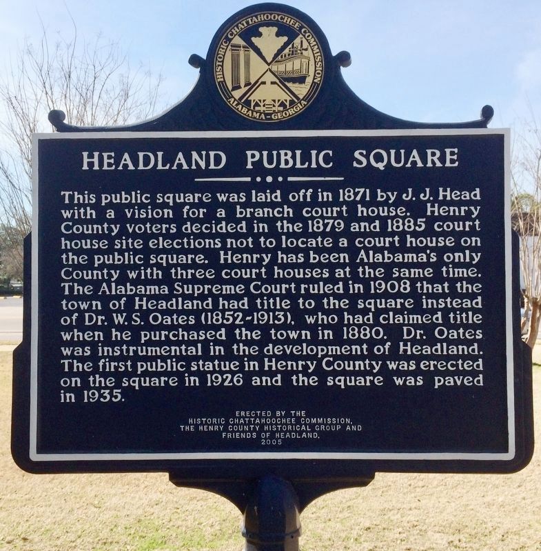
Headland Public Square Marker
| On Main Street 0.1 miles south of Alabama Route 173, on the right when traveling north. |
| On Museum Avenue, on the right when traveling north. |
| Near Valley View Drive west of Richard Arrington Jr Boulevard South. |
| Near Richard Arrington Junior Boulevard South 0.4 miles south of 16th Avenue South, on the right when traveling south. |
| Near Valley View Drive west of Richard Arrington Jr Boulevard South. |
| On South Broadnax Street at Eufalla Street, on the right when traveling south on South Broadnax Street. |
| On East County 5th Street near South Avenue 39 East, on the right when traveling east. |
| On East Walnut Street (State Highway 22/109) near Airport Industrial Road. |
| On Mill Street at 3rd Street on Mill Street. |
| Near Route 206 4 miles west of Newville Road (Route 200), on the right when traveling west. |
| On Foothill Boulevard at La Canada Boulevard, on the right when traveling west on Foothill Boulevard. |
| On Chapman Avenue at Marks Way, on the right when traveling west on Chapman Avenue. |
| On Handy Street at Katella Avenue on Handy Street. |
| On Taylor Road west of Horseshoe Bar Road, on the right when traveling west. |
| On Euclid Avenue (California Route 83) near C Street, in the median. |
| On Horse Camp Road, on the left. |
| Near Washington Avenue south of 10th Street, on the right when traveling south. |
| On 8th Street (State Highway 285) north of Pitkin Avenue, on the right when traveling north. |
| Near Cedar Street (Connecticut Route 175) at Mill Street, on the left when traveling west. |
| Near Howe Avenue (Connecticut Route 110) near Roberts Street, on the right when traveling north. |
| On Atlantic Street at Main Street, on the right when traveling north on Atlantic Street. |
| On Grove Street at Main Street, on the left when traveling north on Grove Street. |
| On Westover Road, on the right when traveling south. |
| On 15th Street Northwest at G Street Northwest, on the right when traveling south on 15th Street Northwest. |
| On L Street Northwest 0.1 miles west of 24th Street Northwest, on the right when traveling west. |
| Near Harbor Walk Drive 0.1 miles north of Nesbit Street. |
| On South De Villiers Street south of Whibbs Drive, on the right when traveling south. |
| On Tamiami Trail/14th Street West (U.S. 41 BUS) just north of 23rd Avenue West, on the left when traveling north. |
| Near Rio Grande Avenue just north of West Church Street, on the right when traveling north. |
| On West International Speedway Boulevard (U.S. 92) west of White Street, on the right when traveling west. |
| On West Indiana Avenue west of North Woodland Boulevard, on the right when traveling west. |
| Near Evard Avenue at Elkcam Boulevard, on the right when traveling north. |
| Near State Road 67 0.3 miles south of Burkhalter Road, on the left when traveling south. |
| On Haynes Street at Washington Avenue, on the right when traveling north on Haynes Street. |
| On Washington Ave. (Georgia Route 120). |
| On 6th Street just north of Reynolds Street, on the left when traveling north. |
| Near S. Upper Blacks Creek Road 1.3 miles north of E. Blacks Creek Road. |
| On North Northwest Highway, on the right when traveling north. |
| On Adams Street at Thomas Avenue, on the right when traveling east on Adams Street. |
| On Gartner Road 0.1 miles north of Edgewater Drive, on the right when traveling south. |
| On Circle Drive south of North Shore Drive. |
| On East Jackson Street west of North Washington Street, on the right when traveling east. |
| On North Chicago Street at Broadway Street, on the left when traveling north on North Chicago Street. |
| On 5th Street (Business Interstate 55) at South Madison Street, on the right when traveling east on 5th Street. |
| On Keokuk Street west of Ottawa Street, on the right when traveling west. |
| On Broadway Street, on the right when traveling east. |
| On 5th Street west of South Washington Street, on the left when traveling west. |
| On Latham Place at Kickapoo Street, on the left when traveling west on Latham Place. |
| On Decatur Street south of 4th Street, on the right when traveling south. |
| On Broadway Street at South Chicago Street, on the left when traveling west on Broadway Street. |
| On U.S. 24 at Harper Road, on the right when traveling east on U.S. 24. |
| On South Main Street at West Huntington Street (Indiana Route 18), on the left when traveling north on South Main Street. |
| On College Avenue 0.1 miles north of North 3rd Street, on the right when traveling north. |
| On State Road 57 north of County Road 150N, on the left when traveling north. |
| On N A Street (U.S. 40) at 7th Street, on the right when traveling west on N A Street. |
| On North 6th Street just north of Central Avenue (State Route 9), on the right when traveling north. |
| On Commercial Street (State Highway 99), on the right when traveling south. |
| On Neosho Street (State Highway 177) near Elm Street, on the right when traveling south. |
| On Nebo Road (Alternate U.S. 41) 0.3 miles south of Shepherd Lane, on the right when traveling south. |
| On College Street at Corgi Lane, on the right when traveling north on College Street. |
| On South Main Street, on the right when traveling south. |
| On Kentucky Route 90, on the right when traveling south on Kentucky Route 90. |
| On Patterson Drive north of Chelsea Street, on the right when traveling north. |
| On St. Bernard Street, on the left when traveling south. |
| On NE Central Avenue near East Mulberry Street, on the left when traveling north. |
| Near West All Saints Street. |
| Near South Court Street, on the right when traveling north. |
| On Church Street at Market Street, on the right when traveling east on Church Street. |
| On Ice Street north of West South Street (Route 144), on the right when traveling south. |
| On Ice Street at West All Saints Street when traveling north on Ice Street. |
| On Conway Street at Silver Street, on the right when traveling south on Conway Street. |
| On Mohawk Trail just west of Factory Hollow Road. |
| On Deerfield Street (U.S. 5) at Meridian Street, on the right on Deerfield Street. |
| On Main St. (Massachusetts Route 2A) 0.1 miles east of US5 & Hwy 2A, on the right when traveling west. |
| On Main St. (Massachusetts Route 2A) at US5 & Hwy 2A, on the right when traveling east on Main St.. |
| On Hubbard Street at Chestnut Street, on the right when traveling east on Hubbard Street. |
| On North Broadway, on the right when traveling south. |
| On South Matteson Street north of East Corey Street, on the right when traveling north. |
| On East Chicago Street (U.S. 12) at Marshall Street (Old U.S. 27), on the left when traveling east on East Chicago Street. |
| Near Interstate 96 at milepost 87, 1.5 miles east of Wright Road (Michigan Route 100). |
| On Monument Road 0.1 miles north of Kokosing Road, on the right when traveling north. |
| On West Lake Street (U.S. 23) north of Whittemore Street, on the right when traveling north. |
| Near Interstate 94 at milepost 84, in the median. |
| On U.S. 131 at milepost 43, on the right when traveling south. |
| On West Maumee Street (Business U.S. 223) at West Church Street (Business U.S. 223), on the right when traveling west on West Maumee Street. |
| On West Maumee Street (Business U.S. 223) at West Church Street (Business U.S. 223), on the right when traveling west on West Maumee Street. |
| On West Maumee Street (Business Highway 223) at West Church Street (Business U.S. 223), on the right when traveling west on West Maumee Street. |
| On North State Street (Business Interstate 75) north of Marquette Street, on the right when traveling north. |
| Near East 5th Street 0.5 miles east of Bluff Street, on the left when traveling east. |
| On 6th Avenue Southeast at 3rd Street Southeast, on the right when traveling south on 6th Avenue Southeast. |
| On East Howard Street (Business U.S. 169) at 4th Avenue East, on the right when traveling east on East Howard Street. |
| On East Howard Street (Business U.S. 169) east of 1st Avenue, on the right when traveling east. |
| On 9th Avenue west of Prentice Street, on the right when traveling east. |
| On Main Street at Bridge Street, on the left when traveling east on Main Street. |
| On Irving Avenue near Lynn Street, on the right when traveling north. |
| On Washington Street at Rollins Street, on the left when traveling east on Washington Street. |
| On Broadway east of Main Street, on the left when traveling east. |
| On West Third Street near Locust Street, on the left when traveling west. |
255 entries matched your criteria. The first 100 are listed above.
Next 100 ⊳
