THE HISTORICAL
MARKER DATABASE
“Bite-Size Bits of Local, National, and Global History”


4630 entries match your criteria. The first 100 are listed.                                               Next 100 ⊳


Historical Markers and War Memorials in Alabama

 
By Mark Hilton, August 26, 2013
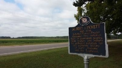
Albert J. Pickett Marker
1 ► Alabama, Autauga County, Autaugaville — Albert J. Pickett — 1810-1858 — Scholar-Planter-Trader
On Alabama Route 14 at County Road 133, on the right when traveling west on Alabama Route 14. Reported permanently removed.
2 ► Alabama, Autauga County, Autaugaville — Albert J. Pickett (1810-1858) — Alabama Historian —
On Alabama 14 at County Road 133, on the left when traveling east on Alabama 14.
3 ► Alabama, Autauga County, Autaugaville — Autaugaville — Intersection of Autauga and Academy Streets — "America's First Crossroad" —
On South Autauga Street at Academy Street, on the right when traveling south on South Autauga Street.
4 ► Alabama, Autauga County, Autaugaville — Greater Mallard's Chapel A.M.E. Church Cemetery — Autauga County —
On County Road 9 S 0.2 miles north of State Route 14, on the left when traveling north.
5 ► Alabama, Autauga County, Autaugaville — Taylor Family Cemetery — Autauga County —
On County Road 78 0.8 miles west of State Highway 14, on the left when traveling west.
6 ► Alabama, Autauga County, Autaugaville, Winslow — Old Harmony Cemetery — Autauga County —
On County Road 45N 0.5 miles north of County Road 44, on the right when traveling north.
7 ► Alabama, Autauga County, Booth — Robinson-DeJarnette Cemetery — Autauga County —
Near County Road 165 at Hilltop Farm Road, on the left when traveling south.
8 ► Alabama, Autauga County, Booth — William D. Smith Family Cemetery — Autauga County —
On County Road 3 1.9 miles south of U.S. 82, on the left when traveling south.
9 ► Alabama, Autauga County, Independence — James Jackson Family Cemetery — Autauga County —
On County Road 79 0.6 miles south of County Road 72, on the left when traveling north.
10 ► Alabama, Autauga County, Marbury — Alabama Forests —
Near County Road 63 0.3 miles south of County Road 530, on the right when traveling south.
11 ► Alabama, Autauga County, Marbury — Mess Hall c. 1920-1929 —
Near County Road 63 0.3 miles south of County Road 530, on the right when traveling south.
12 ► Alabama, Autauga County, Marbury — Myrick Chapel Cemetery — Autauga County — Established 1870 —
On County Road 99 north of County Road 68W, on the right when traveling north.
13 ► Alabama, Autauga County, Marbury — Site of "John E. Moore," "Camp Hardee," "Cottage Number 8" and "Cripple Creek Hotel" Cottages — 1903-1939 —
Near County Road 63 0.2 miles south of County Road 530, on the right when traveling south.
14 ► Alabama, Autauga County, Marbury — Site of the E. L. More, Fox Maull, Lizzie Cameron, — The Blue and the Gray, Flowers and "Last Chance" Cottages — 1902 – 1939 —
Near County Road 63 0.3 miles south of County Road 530, on the right when traveling south.
15 ► Alabama, Autauga County, Marbury — The Hospital — 1904-1939 —
Near County Road 63 0.2 miles south of County Road 530, on the right when traveling south.
Paid Advertisement
16 ► Alabama, Autauga County, Milton — Milton —
On Autauga County Road 1, on the right when traveling north.
17 ► Alabama, Autauga County, Mulberry — Ivy Creek Cemetery — 1829 —
Near Alabama 14 0.2 miles west of County Road 9.
18 ► Alabama, Autauga County, Mulberry — Ivy Creek Methodist Church — Autauga County —
On Alabama Route 14 0.4 miles west of County Road 9, on the right when traveling west.
19 ► Alabama, Autauga County, Mulberry — Old Mulberry Schoolhouse — c. 1895 —
On County Road 9 South north of Highway 14, on the left when traveling north.
20 ► Alabama, Autauga County, Prattville — A County Older Than the State, Autauga County —
On East 4th Street west of North Court Street, on the right when traveling west.
21 ► Alabama, Autauga County, Prattville — Alibamo Indians —
On Maple Street 0.2 miles west of Selma Highway, on the right when traveling north.
22 ► Alabama, Autauga County, Prattville — Autauga County Korean War Memorial —
On West 4th Street (Alabama Route 206) at North Court Street, on the right when traveling west on West 4th Street.
23 ► Alabama, Autauga County, Prattville — Autauga County Viet Nam Memorial —
On West 4th Street (Alabama Route 206) at North Court Street, on the right when traveling west on West 4th Street.
24 ► Alabama, Autauga County, Prattville — Autauga County World War II Memorial —
On North Court Street at West 4th Street ( Route 206), on the right when traveling north on North Court Street.
25 ► Alabama, Autauga County, Prattville — Autauga Creek —
Near West Main Street 0.1 miles west of South Chestnut Street, on the right when traveling east.
26 ► Alabama, Autauga County, Prattville — Buena Vista — Montgomery-Janes-Wittaker Home — (circa 1830) —
On County Road 4 0.1 miles west of Buena Vista Boulevard, on the right when traveling west.
27 ► Alabama, Autauga County, Prattville — Daniel Pratt / First United Methodist Church —
On East 4th Street at South Chestnut Street, on the right when traveling east on East 4th Street.
28 ► Alabama, Autauga County, Prattville — Daniel Pratt Cemetery / George Cooke —
Near Gin Shop Hill Road.
29 ► Alabama, Autauga County, Prattville — Doster Road Artesian Well House —
On Doster Road at Mobile Drive, on the right when traveling south on Doster Road.
30 ► Alabama, Autauga County, Prattville — First Missionary Baptist Church — Autauga County —
On 7th Street at N Court Street, on the right when traveling west on 7th Street.
31 ► Alabama, Autauga County, Prattville — First Presbyterian Church of Prattville, Alabama / Original Members —
On East 3rd Street at South Chestnut Street, on the right when traveling east on East 3rd Street.
Paid Advertisement
32 ► Alabama, Autauga County, Prattville — Happy Hollow —
On East Sixth Street 0.4 miles east of North Northington Street, on the right when traveling west.
33 ► Alabama, Autauga County, Prattville — Heritage Park —
On South Court Street at West Main Street, on the right when traveling south on South Court Street.
34 ► Alabama, Autauga County, Prattville — Indian Springs Post Office • Thomas Hill House • Union Baptist Meeting House —
On Dosterville Road 1.5 miles west of South Memorial Drive (U.S. 31), on the left when traveling west.
35 ► Alabama, Autauga County, Prattville — Mount Sinai Rosenwald School — Autauga County —
On County Road 57 just north of County Road 6, on the right when traveling north.
36 ► Alabama, Autauga County, Prattville — Mulbry Grove Cottage — McWilliams - Smith - Rice House —
On Main Steet at South Chestnut Sreet, on the right when traveling east on Main Steet.
37 ► Alabama, Autauga County, Prattville — North Highland Park —
On Martin Luther King Drive north of Cone Street, on the right when traveling north.
38 ► Alabama, Autauga County, Prattville — Old Autauga County Courthouse — 1870 —
On South Court Street at West 3rd Street, on the left when traveling south on South Court Street.
39 ► Alabama, Autauga County, Prattville — Old Kingston Historical Cemetery —
On County Road 21 0.1 miles south of County Road 40, on the left when traveling south.
40 ► Alabama, Autauga County, Prattville — Old Plank Road — Circa 1840's —
On Maple Street at Pletcher Street, on the right when traveling west on Maple Street.
41 ► Alabama, Autauga County, Prattville — Pratt Gin Factory — 1 mile —
On East Main Street at South Memorial Drive (U.S. 31), on the right when traveling east on East Main Street.
42 ► Alabama, Autauga County, Prattville — Pratt Homesite — Circa 1842 —
On Bridge Street at Gin Shop Hill Road, on the right when traveling west on Bridge Street.
43 ► Alabama, Autauga County, Prattville — Prattville Dragoons —
On South Washington Street at East 4th Street, on the right when traveling north on South Washington Street.
44 ► Alabama, Autauga County, Prattville — Rocky Mount Cemetery —
On Rocky Mount Road 1.1 miles north of Cobbs Ford Road (U.S. 82), on the right when traveling north.
45 ► Alabama, Autauga County, Prattville — Saint Mark's Episcopal Church —
On East 4th Street at South Washington Street, on the right when traveling east on East 4th Street.
46 ► Alabama, Autauga County, Prattville — Sallie Mae Hadnott — (1920-1991) —
On Upper Kingston Road at Hadnott Way, on the right when traveling north on Upper Kingston Road.
47 ► Alabama, Autauga County, Prattville — Sidney Lanier — Musician - Poet - Patriot - Seer —
Near Wetumpka Street at South Washington Street, on the right when traveling east.
Paid Advertisement
48 ► Alabama, Autauga County, Prattville — Sidney Lanier / Prattville Male and Female Academy Site —
On Wetumpka Street (County Route 2) at South Washington Street, on the right when traveling east on Wetumpka Street.
49 ► Alabama, Autauga County, Prattville — The Prattville Dragoons —
Near South Washington Street at East 4th Street, on the left when traveling south.
50 ► Alabama, Autauga County, Prattville — Wilson Pickett, Jr. — March 18, 1941 - January 19, 2006 —
On South Chestnut Street at 1st Street, on the right when traveling south on South Chestnut Street.
51 ► Alabama, Autauga County, Vine Hill — Vine Hill Presbyterian Church Cemetery — Autauga County —
On County Road 22 0.3 miles east of County Road 130, on the left when traveling north.
52 ► Alabama, Autauga County, White City — White City Cemetery —
On County Road 21 south of County Road 20, on the right when traveling south.
53 ► Alabama, Baldwin County, Barnwell — Barnwell / Cavanac —
On County Road 3 0.7 miles east of Greeno Road (U.S. 98), on the right when traveling east.
54 ► Alabama, Baldwin County, Bay Minette — A County Older Than the State, Baldwin County —
On Courthouse Square (U.S. 31) at Hand Avenue, on the left when traveling east on Courthouse Square.
55 ► Alabama, Baldwin County, Bay Minette — Baldwin County Eternal Flame Veterans Memorial —
On Courthouse Square (U.S. 31) at D'Olive Street, on the left when traveling east on Courthouse Square.
56 ► Alabama, Baldwin County, Bay Minette — Bay Minette Korean War Memorial —
On Hall Avenue (U.S. 31) at D'Olive Street on Hall Avenue.
57 ► Alabama, Baldwin County, Bay Minette — Bay Minette, Alabama —
On West 2nd Street east of McMillan Avenue, on the right when traveling east.
58 ► Alabama, Baldwin County, Bay Minette — Bottle Creek Site —
On Courthouse Square (U.S. 31) at Hand Avenue, on the left when traveling east on Courthouse Square.
59 ► Alabama, Baldwin County, Bay Minette — Judge Harry Toulmin — (1766 – 1823) —
On Courthouse Square (U.S. 31) at Hand Avenue, on the left when traveling west on Courthouse Square.
60 ► Alabama, Baldwin County, Bay Minette — Lynching in America / The Lynching of Rueben Sims — Community Remembrance Project —
On Courthouse Square at U.S. 31, on the left when traveling north on Courthouse Square.
61 ► Alabama, Baldwin County, Bay Minette — Stephen J. Boykin / The American Banner —
On Shedrick Hardy Parkway 0.1 miles south of Rain Drive, on the right when traveling south.
62 ► Alabama, Baldwin County, Blakeley — Alabama —
On Washington Avenue south of Old Blakeley Road, on the right when traveling south.
63 ► Alabama, Baldwin County, Blakeley — Battle of Blakeley — April 9, 1865 —
On Washington Avenue south of Old Blakeley Road, on the right when traveling south.
Paid Advertisement
64 ► Alabama, Baldwin County, Blakeley — Fort Blakeley (Blakely*) —
Near Battlefield Road 0.3 miles east of Green Street, on the right when traveling east.
65 ► Alabama, Baldwin County, Blakeley — Redoubt Six —
On Old Blakeley Road, on the right when traveling south.
66 ► Alabama, Baldwin County, Blakeley — Ruins of the original Foundation of Baldwin County's First Courthouse
On Franklin Street, on the right when traveling north. Reported permanently removed.
67 ► Alabama, Baldwin County, Blakeley — Site of Baldwin County's First Courthouse —
On Franklin Street north of Washington Avenue, on the right when traveling north.
68 ► Alabama, Baldwin County, Blakeley — The Apalachee Village —
On Franklin Street 0.4 miles north of Washington Avenue, on the right when traveling west.
69 ► Alabama, Baldwin County, Blakeley — The Battle of Fort Blakeley —
On Battlefield Road 0.3 miles east of Green Street.
70 ► Alabama, Baldwin County, Blakeley — The Battle of Fort Blakely —
On Battlefield Road 0.8 miles east of Green Street, on the right when traveling north.
71 ► Alabama, Baldwin County, Blakeley — The Bottle Creek Site — Alabama Indigenous Mound Trail —
On Franklin Street 0.4 miles north of Washington Avenue, on the right when traveling west.
72 ► Alabama, Baldwin County, Blakeley — The Siege of Fort Blakeley —
On Battlefield Road, on the left when traveling east.
73 ► Alabama, Baldwin County, Blakeley — The Town of Blakeley —
On Franklin Street 0.1 miles north of Washington Avenue, on the left when traveling north.
74 ► Alabama, Baldwin County, Blakeley — The United States Colored Troops (USCT) at the Battle of Fort Blakeley —
On Battlefield Road, on the left when traveling east.
75 ► Alabama, Baldwin County, Blakeley — Union Artillery Batteries —
On Union Trail Loop west of Old Blakeley Road, on the left.
76 ► Alabama, Baldwin County, Bon Secour — The Charles Swift Family / Swift Coles Historic Home —
On County Road 49 at Swift Coles Lane, on the left when traveling south on County Road 49.
77 ► Alabama, Baldwin County, Bon Secour — Stop 3 — Vicinity of Salt Works and Camp Anderson — “Salt Is Eminently Contraband” — Civil War Trail Battle for Mobile Bay —
On River Road 0.2 miles west of Bon Secour Highway, on the left when traveling west.
78 ► Alabama, Baldwin County, Daphne — 1814 - 1977 — General Andrew Jackson —
On Main Street south of Bayfront Park Drive, on the right when traveling south.
79 ► Alabama, Baldwin County, Daphne — City of Daphne — Incorporated July 8, 1927 —
On Main Street at Manci Avenue, on the right when traveling south on Main Street.
Paid Advertisement
80 ► Alabama, Baldwin County, Daphne — Colonia Italiana 1888-The Beautiful Forest / The Founding Fathers of the Italian Colony —
On Daphne Road (County Road 64) near State Route 181, on the right when traveling west.
81 ► Alabama, Baldwin County, Daphne — Daphne United Methodist Church —
Near 6th Avenue.
82 ► Alabama, Baldwin County, Daphne — Fuller Memorial Park —
On Patrician Drive W 0.1 miles north of Patrician Drive S, in the median.
83 ► Alabama, Baldwin County, Daphne — Little Bethel Baptist Church: —
On Main Street (County Road 98) at Magnolia Avenue, on the right when traveling north on Main Street.
84 ► Alabama, Baldwin County, Daphne — Patriot's Point Memorial —
Near U.S. 98 at Whispering Pines Road.
85 ► Alabama, Baldwin County, Daphne — The Eastern Shore Trail —
On N Main St.
86 ► Alabama, Baldwin County, Daphne — The Village —
On Main Street south of U.S. 89.
87 ► Alabama, Baldwin County, Daphne — Yancey Crane Cemetery — Baldwin County —
On U.S. 98 north of Whispering Pines Road, on the right when traveling north.
88 ► Alabama, Baldwin County, Elsanor — Elsanor —
On U.S. 90 at Thelma Burke Road/Poplar Road, on the right when traveling west on U.S. 90.
89 ► Alabama, Baldwin County, Fairhope — Brodbeck and Zundel General Merchandise Store —
On Scenic Highway 98 (Alternate U.S. 98) near Zundel Road, on the right when traveling south.
90 ► Alabama, Baldwin County, Fairhope — City of Fairhope —
On North Section Street north of Fairhope Ave, on the right when traveling north.
91 ► Alabama, Baldwin County, Fairhope — Confederate Rest Cemetery —
On Pine Grove Drive near Confederate Rest Road, on the right when traveling west.
92 ► Alabama, Baldwin County, Fairhope — Craig Turner Sheldon — 1917-1997 —
On 24 N Section Street.
93 ► Alabama, Baldwin County, Fairhope — Fairhope Colony Cemetery — 1895 / Historic Site —
On Oak Avenue at N Church Street, on the right when traveling west on Oak Avenue.
94 ► Alabama, Baldwin County, Fairhope — Fairhope Museum of History —
On 24 N Section Street at Fairhope Avenue, on the right when traveling north on 24 N Section Street.
95 ► Alabama, Baldwin County, Fairhope — Land, Capital, Labor —
On N Beach Road.
Paid Advertisement
96 ► Alabama, Baldwin County, Fairhope — Marietta Johnson —
On South Mobile Street.
97 ► Alabama, Baldwin County, Fairhope — Nancy Lewis / Stewart the Picture Man —
On South Bancroft Street, on the left when traveling south on South Bancroft Street.
98 ► Alabama, Baldwin County, Fairhope — Tears of Sorrow — Tears of Joy —
On N Beach Road.
99 ► Alabama, Baldwin County, Fairhope — Welcome to the Fairhope Pier — Fairhope’s ‘town square’ —
On 4 N Beach Road.
100 ► Alabama, Baldwin County, Fairhope, Montrose Historic District — Ecor Rouge —
On Eastern Shore Trail south of Taylor Street, on the left when traveling north.

4630 entries matched your criteria. The first 100 are listed above. Next 100 ⊳

 
 
CeraNet Cloud Computing sponsors the Historical Marker Database.
This website earns income from purchases you make after using our links to Amazon.com. We appreciate your support.
Paid Advertisement
Nov. 10, 2026