56 entries match your criteria.
Historical Markers and War Memorials
in Northern BC Region
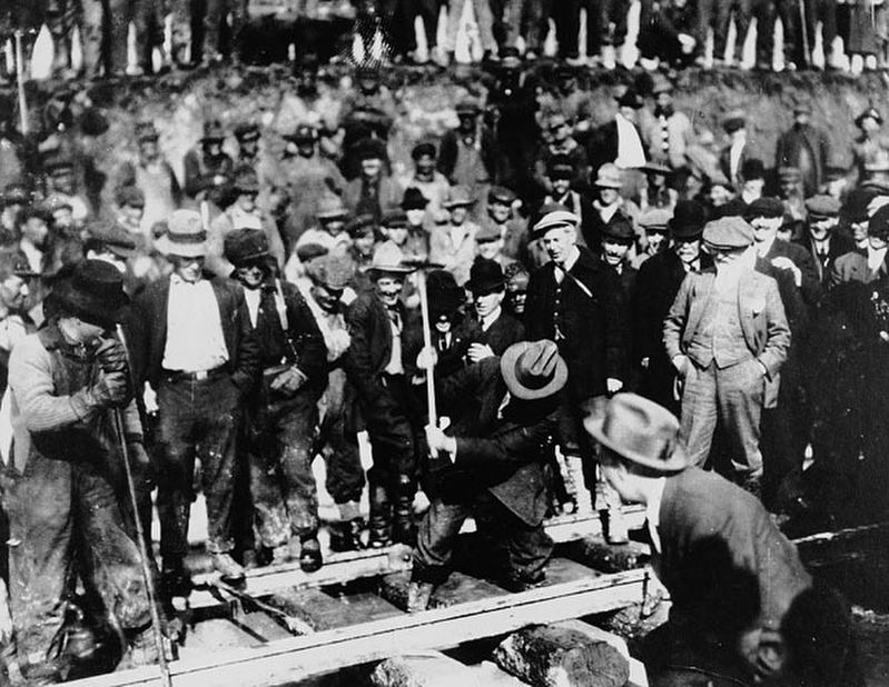
Unknown via British Columbia Archives (Public domain), April 7, 1914
Grand Trunk Pacific Railway — Last Spike
1 ► British Columbia, Bulkley-Nechako, Fort Fraser — Grand Trunk Pacific —  |
| On Fourth Avenue/Yellowhead Highway (Provincial Highway 16) west of Telegraph Road, on the left when traveling west. | |||
| 2 ► British Columbia, Bulkley-Nechako, Southbank — Ootsa Lake Nechako Reservoir — |
| On Ootsa Lake Road, on the left when traveling west. | |||
| 3 ► British Columbia, Bulkley-Nechako, Telkwa — Overland Telegraph — |
| On Yellowhead Highway (Provincial Highway 16) 0.5 kilometers west of George Frontage Road, on the left when traveling west. | |||
| 4 ► British Columbia, Kitimat-Stikine, Bob Quinn Lake — Yukon Telegraph — |
| On Dease Lake Highway/Stewart-Cassiar Highway (Provincial Highway 37) 5.6 kilometers south of Bob Quinn Forest Service Road, on the right when traveling south. | |||
| 5 ► British Columbia, Kitimat-Stikine, Cedarvale — Skeena River Boats — |
| On Yellowhead Highway (Provincial Highway 16) 13 kilometers south of Cedarvale Ferry Road, on the right when traveling south. | |||
| 6 ► British Columbia, Kitimat-Stikine, Hagwilget — The Hagwilget Bridges — |
| On Highway 62 just north of Tse Kya Road, on the left when traveling north. | |||
| 7 ► British Columbia, Kitimat-Stikine, Hazelton — Hazelton — |
| On Government Street at Bay Street, on the left when traveling north on Government Street. | |||
| 8 ► British Columbia, Kitimat-Stikine, Moricetown — Moricetown Canyon — |
| On Yellowhead Highway (National Route 16), on the right when traveling west. | |||
| 9 ► British Columbia, Kitimat-Stikine, New Hazelton — People of the Skeena — |
| Near 9 Avenue just west of Churchill Road. | |||
| 10 ► British Columbia, Kitimat-Stikine, Stewart — Anglo-Russian Treaty of 1825 — |
| On Columbia St, on the right when traveling south. | |||
| 11 ► British Columbia, North Coast, Port Edward — Inverness Cannery — |
| On Skeena Drive, on the right when traveling south. | |||
| 12 ► British Columbia, North Coast, Port Edward — North Pacific Cannery — |
| On Skeena Drive, on the right when traveling south. | |||
| 13 ► British Columbia, North Coast, Prince Rupert — Alder House Frontal Pole — |
| On 3rd Avenue at 3rd Street, on the right when traveling west on 3rd Avenue. | |||
| 14 ► British Columbia, North Coast, Prince Rupert — Anget Pole of Ninstints — |
| On 3rd Avenue at 3rd Street, on the right when traveling west on 3rd Avenue. | |||
| 15 ► British Columbia, North Coast, Prince Rupert — Charles Melville Hays — 1856 - 1912 — "Founder of Our City" — |
| On 3 Avenue West just south of 3 Street, on the right when traveling south. | |||
| 16 ► British Columbia, North Coast, Prince Rupert — Eagle on Decayed Pole — |
| On Market Place east of 1Ave E, on the left when traveling east. | |||
| 17 ► British Columbia, North Coast, Prince Rupert — Former Federal Building/City Hall — Est. 1939 — |
| On 3 Avenue West just south of 3 Street, on the right when traveling south. | |||
| 18 ► British Columbia, North Coast, Prince Rupert — Franklin D. Roosevelt Park — |
| On Summit Avenue south of Taylor Street, on the left when traveling south. | |||
| 19 ► British Columbia, North Coast, Prince Rupert — Grizzly Bear Pole — |
| On Summit Avenue south of Taylor Street, on the right when traveling south. | |||
| 20 ► British Columbia, North Coast, Prince Rupert — Historic Cow Bay — Prince Rupert, British Columbia — |
| On Cow Bay Road south of George Hills Way, on the right when traveling south. | |||
| 21 ► British Columbia, North Coast, Prince Rupert — Kazu Maru Memorial — |
| On 1 Avenue East south of Manson Way, on the right when traveling south. | |||
| 22 ► British Columbia, North Coast, Prince Rupert — Kwinitsa Railway Museum — |
| On Bill Murray Drive west of 1st Avenue West, on the left when traveling north. | |||
| 23 ► British Columbia, North Coast, Prince Rupert — Lieutenant Colonel Cyrus Wesley Peck, VC, DSO & Bar — 1871 - 1956 — |
| On Bill Murray Drive west of 1st Avenue West, on the left when traveling north. | |||
| 24 ► British Columbia, North Coast, Prince Rupert — Lloyd Ernest Bud Pierce — 1926 - 1984 — |
| On Market Place east of 1 Avenue East, on the right when traveling north. | |||
| 25 ► British Columbia, North Coast, Prince Rupert — MacKenzie Furniture Ltd. — |
| On 1st Avenue West north of 1 Street, on the left when traveling north. | |||
| 26 ► British Columbia, North Coast, Prince Rupert — Mother Grey Whale and Calf — |
| On Bill Murray Drive west of 1st Avenue West, on the left when traveling north. | |||
| 27 ► British Columbia, North Coast, Prince Rupert — Mural: Our Wealth — |
| On 1 Avenue East north of Market Place, on the right when traveling north. | |||
| 28 ► British Columbia, North Coast, Prince Rupert — Mural: Our Wealth — |
| On 1 Avenue East north of Market Place, on the right when traveling north. | |||
| 29 ► British Columbia, North Coast, Prince Rupert — Pillsbury House — circa 1907 — |
| On Bill Murray Drive west of 1st Avenue West, on the right when traveling west. | |||
| 30 ► British Columbia, North Coast, Prince Rupert — Prince Rupert B. C. — |
| On Summit Avenue 0.4 kilometers south of Taylor Street, on the right when traveling south. | |||
| 31 ► British Columbia, North Coast, Prince Rupert — Prince Rupert Cenotaph — |
| On Market Place east of 1 Avenue East, on the right when traveling east. | |||
| 32 ► British Columbia, North Coast, Prince Rupert — Prince Rupert Courthouse Cornerstone — |
| On Market Place, on the right when traveling west. | |||
| 33 ► British Columbia, North Coast, Prince Rupert — Private Allan Milton Olsen — |
| On Market Place east of 1 Avenue East, on the right when traveling east. | |||
| 34 ► British Columbia, North Coast, Prince Rupert — Sons of Norway — Vinland Lodge 28 — |
| On 1st Avenue East south of Manson Way, on the right when traveling south. | |||
| 35 ► British Columbia, North Coast, Prince Rupert — Triple Island Lighthouse / Le Phare de L'ile Triple — |
| Near 1 Avenue East at Market Place, on the right when traveling south. | |||
| 36 ► British Columbia, North Coast, Prince Rupert — Workers’ Memorial — |
| On 1 Avenue East, on the right when traveling west. | |||
| 37 ► British Columbia, North Coast, Prince Rupert — The Kazu Maru Memorial — Pacific Mariners’ Memorial Park — Prince Rupert, British Columbia — |
| Near 1st Avenue East south of Manson Way, on the right when traveling south. | |||
| 38 ► British Columbia, North Coast, Tyee — “K-Shian” – The Skeena — |
| On Yellowhead Highway (National Route 16), on the left when traveling west. | |||
| 39 ► British Columbia, Peace River, Dawson Creek — Alaska Highway / La Route De L’Alaska — Completed in 1942 / Terminé en 1942 — International Historic Civil Engineering Landmark / Monument Historique International du Génie Civil — |
| On Alaska Ave (National Highway 2) near 8th Street, in the median. | |||
| 40 ► British Columbia, Peace River, Hudson's Hope — Alexander Mackenzie — |
| Near Canyon Drive 0.5 kilometers east of Ski Hill Road, on the left when traveling east. | |||
| 41 ► British Columbia, Peace River, Pouce Coupe — Dawson Creek — |
| On John Hart Highway (Provincial Highway 97) 0.2 kilometers west of 223 Road, on the left when traveling west. | |||
| 42 ► British Columbia, Peace River, Taylor — The First Highway — |
| On Alaska Highway (Provincial Highway 97) 0.6 kilometers north of Pingel Creek Road, on the right when traveling north. | |||
| 43 ► British Columbia, Peace River, Tumbler Ridge — Cretaceous Trackway — |
| On Don Phillips Way (Provincial Highway 29) 0.8 kilometers west of Heritage Highway (Provincial Highway 52), on the left when traveling west. | |||
| 44 ► British Columbia, Stikine Region, Atlin — Atlin Cemetery — |
| On Surprise Lake Road 1.3 kilometers north of Warm Bay Road, on the left when traveling north. | |||
| 45 ► British Columbia, Stikine Region, Atlin — Bennett — |
| Near British Columbia Route 2, on the right when traveling north. | |||
| 46 ► British Columbia, Stikine Region, Atlin — Me`n Cho`Bennett Lake — Chinkoot National Trail Historic Site — |
| On no nearby street. | |||
| 47 ► British Columbia, Stikine Region, Atlin — St. Andrew's Church — Chilkoot Trail National Historic Site — |
| On no nearby road. | |||
| 48 ► British Columbia, Stikine Region, Bennett — A Precious Place / Un endroit préciux — |
| Near Chilkoot Trail, on the right when traveling north. | |||
| 49 ► British Columbia, Stikine Region, Bennett — Chilkoot Trail National Historic Site / Lieu historique national de la Piste-Chilkoot — |
| Near Chilkoot Trail (British Columbia Route 98) 19.3 kilometers north of Dyea Road, on the right when traveling north. | |||
| 50 ► British Columbia, Stikine Region, Bennett — End of Trail / Fin de la piste — Chilkoot Trail National Historic Site / Lieu historique national de la Piste-Chilkoot — Parks Canada — |
| Near Chilkoot Trail (British Columbia Route 98) 19.3 kilometers north of Dyea Road, on the right when traveling north. | |||
| 51 ► British Columbia, Stikine Region, Bennett — Names on the land / Noms de la terre — |
| Near Chilkoot Trail (British Columbia Route 98) 19.3 kilometers north of Dyea Road, on the right when traveling north. | |||
| 52 ► British Columbia, Stikine Region, Bennett — St. Andrew's Church / Église St. Andrew's — |
| On Chilkoot Trail. | |||
| 53 ► British Columbia, Stikine Region, Bennett — Welcome / Bienvenue — |
| Near Chilkoot Trail (British Columbia Route 98) 19.2 kilometers north of Dyea Road, on the right when traveling north. | |||
| 54 ► British Columbia, Stikine Region, Centreville — Cassiar Gold Rush — |
| On Dease Lake Highway/Stewart-Cassiar Highway (Provincial Highway 37) 7.2 kilometers west of Good Hope Lake Band Road, on the left when traveling west. | |||
| 55 ► British Columbia, Stikine Region, Fraser — Fraser — |
| On Klondike Highway, on the left when traveling south. | |||
| 56 ► British Columbia, Stikine Region, Fraser, Watson — Fraser — Welcome to Canada: Welcome to the Yukon — |
| On Klondike Highway. | |||