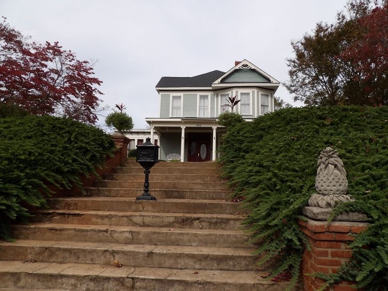
On West Market Street west of South Prevost Street, on the right when traveling west.
This Victorian home was built by J. Thomas Bolt, great nephew of Oliver Bolt who operated the first electrified cotton gin in the world. J. Thomas Bolt was a cotton merchant, and owned B&B Motor Company. — — Map (db m185517) HM
On East Greenville Street (State Highway 81), on the right when traveling north.
The original Anderson High School sat on the corner of North Fant and East Calhoun Streets. All grade levels were taught despite being called a high school. This school burned down in 1904 and was rebuilt the following year. Due to overcrowding, . . . — — Map (db m65305) HM
Building History
Built in the 1930s by Frank R. Thompson, this building was the main street depot for the Anderson Petroleum Company and Dixie Distributors, Inc., both successful petroleum distributors in Anderson, Oconee, Pickens, . . . — — Map (db m42762) HM
This building constructed in 1912
is named in honor of
Dr. Annie Dove Denmark
associated with Anderson College for
36 years, serving as President of the
college from 1928-1953. Dr. Denmark
was a resident of this dormitory
during . . . — — Map (db m19738) HM
On Due West Highway (State Highway 185) at County Road 17-60A, on the left when traveling west on Due West Highway.
[Front]:
This church, formally organized by about 1800, is thought to be the oldest Methodist congregation in Anderson County. Circuit riders and other itinerant ministers held early services in a nearby brush arbor. Its first and second . . . — — Map (db m55621) HM
On North Main Street, on the left when traveling south.
This store is the oldest business firm in Anderson. It has been owned and operated consistently by the same family for 175 years. Established by George W. Fant and originally named G.W. Fant & Son the store is an outgrowth of Dr. Edmund Webb's Drug . . . — — Map (db m21292) HM
Near Anderson Independence Mail Boulevard west of Freedom Way.
Famous aviator Amelia Earhart landed on an airfield near here on November 14, 1931. She was piloting a Beechnut Autogiro on a nation wide tour promoting Beechnut Products. It was shortly after completing this tour that she made her famous solo . . . — — Map (db m21250) HM
On West Whitner Street (State Highway 24) west of Towers Street.
Organized Sept. 23, 1837 on land given by J. N. Whitner. First frame structure was built in 1839. Anderson's first cemetery is here, and city's first Sunday School was organized here about 1855. Present sanctuary's cornerstone was laid in 1879. . . . — — Map (db m10727) HM
On Flat Rock Road at Glen Eddie Road (South Carolina Highway 475) on Flat Rock Road.
Serving Country
and
Jesus Christ
Veterans Who Are buried
in Flat Rock Cemetery
[Left Column]
Harry Drake, Daniel Y. Culbertson, J.C. Culbertson, Luther M. Borders, John T Neims, Charles A. Thornton, Berry Faine, Edward . . . — — Map (db m54779) HM
Miss Sarah Jane (Janie) Frierson was a well known educator and the daughter of Dr. David Frierson, an early pastor of the First Presbyterian Church of Anderson. Miss Frierson opened her one room school in the late 1880s. One room schools of this . . . — — Map (db m42189) HM
On South McDuffie Street at East Market Street, on the right when traveling north on South McDuffie Street.
Entered on the National Register
of Historic Places
December 13, 1971
Federal Building
U.S. Courthouse
Federal Postal Station
Anderson, South Carolina
Thomas Harlan Ellett
Architect 1938
This . . . — — Map (db m19912) HM
On East Whitner Street at North McDuffie Street, on the left when traveling east on East Whitner Street.
This building was erected as the home of G.F. Tolly Furniture Company, an outgrowth of Anderson's first cabinet shop established at this site by Ezekiel George. George F. Tolly entered business with Mr. George in 1856. Later married George's . . . — — Map (db m42725) HM
On Webb Street north of West Market Street, on the right when traveling north.
This original postwar bungalow was purchased by Anderson philanthropist and polio stricken Anne J. Gambrill in 1962. Remodeled by noted architect and landscape designer John W. Linley in a relaxed New Orleans style, the antique brick used throughout . . . — — Map (db m185526) HM
On East Greenville Street (State Highway 81), on the right when traveling south.
The Anderson County Museum is situated on the former site of Anderson Girls High School. The original structure, an imposing multi-story brick building, was built in 1918. At that time, both boys and girls attended the school known as Anderson . . . — — Map (db m42249) HM
On South McDuffie Street at East Reed Street, on the left when traveling south on South McDuffie Street.
Front
This Parish, organized in 1851 with the Rev. Benjamin Webb as its first vicar, grew out of occasional Episcopal services held in Anderson as early as 1844. The first church here, a frame Carpenter Gothic building, was completed in . . . — — Map (db m10417) HM
On Broadway Lake Road at Belton Highway (U.S. 178), on the right when traveling east on Broadway Lake Road.
2.9 miles south on Rocky River
Anderson Water, Light, & Power Co.,
organized in 1894 by
William C. Whitner,
was successful the next year
in transmitting electricity over
the distance of six miles
to Anderson.
This achievement was a . . . — — Map (db m88441) HM
On Hopewell Road, on the right when traveling east.
This Baptist church, which was first located about 1.5 miles northwest, was constituted in 1803. The congregation moved to the present 4.4 acre site after it was surveyed December 14, 1822. Two houses of worship were built here before 1891, when . . . — — Map (db m10668) HM
In this burial ground
the first public burial ground
in the City of Anderson, S.C.,
rest fifty or more persons
known only to God.
This plaque is in honor of
those unnamed persons who
lived and died as a part
of the Anderson . . . — — Map (db m54638) HM
Born August 29, 1852
Died February 26, 1905
----------
Founder and President
Orr Cotton Mills
----------
Honest and Fearless in the
Discharge of Every Duty.
Rest in Peace. — — Map (db m15269) HM
On East Greenville Street (State Highway 81), on the right when traveling south.
[Front]
In honor of the
Korean War veterans of
Anderson County
1950-1955
[Reverse]
In honor of the
Viet Nam veterans of
Anderson County
1964-1975 — — Map (db m10674) WM
On South Main Street (South Carolina Route 28) south of East River Street (U.S. 178), on the right when traveling north.
Lynching in America
Between 1865 and 1950, at least 6,500 Black people were victims of lynchings in the United States. The abolition of chattel slavery was not accompanied by a commitment to equal rights or protection for Black people. In many . . . — — Map (db m237660) HM
On Mall Road at Country Club Lane, on the left when traveling west on Mall Road. Reported missing.
• A mobile, full tracked, lightly armored antiaircraft & ground support weapon system.
• Manufactured by Cadillac at the Cleveland Tank Arsenal in the 1950s.
• Weight of 49,500 pounds and a crew of six.
• Powered by a continental air cooled . . . — — Map (db m19918) HM
On East Benson Street west of South McDuffie Street, on the right when traveling east.
This is the second Masonic Temple to occupy this location. After its organization in 1848, Hiram Lodge No. 68 met in the second story of a store building on the east side of the square for several years. The first temple was erected at this . . . — — Map (db m38438) HM
On South McDuffie Street, on the right when traveling north.
McDuffie High School stood
proudly at this location from
1964 until 1996. Serving
Anderson as a comprehensive
vocational high school,
McDuffie enrollment averaged
1000 students each year it was
open. Many of Anderson's
current . . . — — Map (db m59360) HM
The McGee Harness Shop was located on the corner of West Benson Street in downtown Anderson. Mr. James L. McGee was listed in the 1905 Anderson City Directory as a dealer in stock, buggies, wagons, and harnesses. By 1910, the small shop located . . . — — Map (db m42151) HM
“I was always told that if you wanted to amount to anything in life, you should be like the business people on Church Street. It was the most viable part of the black community. Besides that, there were very few places where . . . — — Map (db m312097) HM
On US Highway 29 at Norris Road ( Highway 104), on the left when traveling west on US Highway 29.
Organized in 1789 initially as an Arm
of the Shockley Ferry Church.
Known for a time as Bethesda.
Cooper Bennett was its first pastor.
The oldest church in the Saluda Baptist
Association, it has been a Lighthouse
for the lost and a . . . — — Map (db m10132) HM
In Memory of
Mrs. J.D. Chapman
First President of Woman's Missionary Union
Auxiliary to South Carolina Baptist Convention
1902-1907 1913-1930
Dedicated Christian Missions Leader
of Vision and Ability
Honored by Name of WMU State . . . — — Map (db m19867) HM
On East Greenville Street, on the left when traveling south.
Located 1.09 miles northwest, this cemetery marks the original site of Hopewell Baptist Church which was constituted in 1803. The cemetery contains graves of Revolutionary and Confederate veterans. Some graves are marked by field stones with . . . — — Map (db m10724) HM
On West Whitner Street (State Highway 24) west of State Highway 1028, on the right when traveling west.
The first cotton gin to be powered by electricity transmitted over a long distance stood near this site on the farm of Oliver "Duck" Bolt (1847-1922). In 1897 Bolt, whose gin had previously been powered by a steam engine, contracted with the . . . — — Map (db m15161) HM
Deeded to the City in 1992, these humble grounds are the final resting place for some Orr Mill employees and family members dating to the 1800s. Numerous graves are here, marked and unmarked, including infants.
Help us improve these unique . . . — — Map (db m50102) HM
On East Greenville Street (State Highway 81), on the left when traveling south.
The Orr Monument was never a tombstone, but a cenotaph, or memorial, to Colonel James L. Orr, son of South Carolina Governor James L. Orr. Colonel Orr was an Anderson native, the founder and president of Orr Cotton Mills, and a well known . . . — — Map (db m42246) HM
On North McDuffie Street at Whitner Street on North McDuffie Street.
[Front Marker]:
In 1889, the City of Anderson contracted with a 26 year old native son, an engineering graduate of the University of South Carolina, to build a steam power plant and water system for the city. Keeping up with the . . . — — Map (db m10697) HM
On North McDuffie Street at Whitner Street, on the right when traveling south on North McDuffie Street.
Half mile West on Seneca River
the Portman Shoals Power Plant,
built by William C. Whitner,
began in 1897 the transmission
of high-voltage electricity over
the longest lines then in use for
that purpose in the United States.
The . . . — — Map (db m10696) HM
This building constructed in 1912
is named in honor of
Dr. and Mrs. R.N. Pratt
Outstanding Teachers
at Anderson College
Dr. Pratt - 1922-1927
Mrs. Pratt - 1922-1946 — — Map (db m19745) HM
The idea for a memorial fountain to honor General Robert Anderson, the American Revolutionary hero for whom our county is named, was part of an overall plan to beautify downtown Anderson. Through the efforts of Mrs. Rufus Fant and the Anderson . . . — — Map (db m42186) HM
On State Highway 187 at Old Roberts Church Road on State Highway 187.
Organized in 1789 and sometimes called Simpson's Meetinghouse, this church is one of Anderson County's oldest Presbyterian churches. The Reverend John Simpson was the first minister, and the Reverend David Humphreys served here for 39 years until . . . — — Map (db m31002) HM
On U.S. 29 north of Broadwell Mill Road, on the right when traveling south.
Mount Sinai Methodist Church (½ mi. S) was the home church of the Undenominational Singing Convention, later called the Interdenominational Colored Signing Convention. Formed by 1895, the Convention held annual meetings mostly at local Methodist . . . — — Map (db m268388) HM
On West Reed Street at South Towers Street on West Reed Street.
After another high school was built, Reed Street High was renamed Perry Elementary School.
Perry Elementary later became known as
Perry Child Development Center.
This memorial is dedicated to the students teachers and principals who were a . . . — — Map (db m60542) HM
On West Whitner (State Highway 24) at Rose Hill Street, in the median on West Whitner.
The home of Judge Joseph N. Whitner, Anderson County's founding father, was located at the crest of this will. It stood until recent years when it was torn down. Judge Whitner was a South Carolina House of Representative from Pendleton District . . . — — Map (db m59361) HM
On East River Street (U.S. 76) near South McDuffie Street, on the left when traveling east.
Organized in 1828, this
was the first church in
Anderson. A log meeting
house built in 1830 on
West Benson Street served
the church until 1858
when a frame building
was erected on this site.
A brick church replaced
it in 1888. The . . . — — Map (db m10733) HM
On West Reed Street, on the right when traveling west.
This is the first Negro church established in Anderson County. It was founded immediately after emancipation and incorporated in 1873. The Rev. Philip Morris was its first pastor. The present edifice, built in 1903, replaced two earlier frame . . . — — Map (db m60543) HM
On South Main Street (State Highway 28) south of West Benson Street, on the right when traveling south.
This building was erected in 1891 and has been the home of Sullivan Hardware Company since 1903. In earlier years it was occupied by the Alliance Store operated by Rufus Hill. The Sullivan Firm was founded as a general merchandise store by J.M. . . . — — Map (db m42745) HM
This building was donated to
Anderson College in 1914 by
Mr. Charles S. Sullivan, Sr.
to be used as the President's Home.
In 1965 it was renovated to serve
as the music building. — — Map (db m19804) HM
On North Oakland Avenue north of East Peachtree Street, on the right when traveling north.
Front
Anderson's Jewish Community dates to the antebellum era but grew significantly after 1900 with the arrival of several families from Eastern Europe. This congregation founded as Temple B'nai Israel (Sons of Israel) as early as 1911. . . . — — Map (db m77333) HM
Civic Center of Anderson - 1992
Chris Taylor Memorial Park - Dedicated 1998
Anderson Sports Complex - 1999
Anderson County Amphitheater - 1999
---------------------------
The Anderson County Sports and Entertainment Center . . . — — Map (db m36170) HM
On West Church Street west of South Main Street (State Highway 28).
Church Street was a thriving center for African-American commerce in Anderson, South Carolina from (circa) 1907 until 1980, when most of the buildings were torn down to make way for a parking lot. The citizens on Church Street were educated, . . . — — Map (db m185372) HM
On Manning Street at East Church Street, on the left when traveling south on Manning Street.
Originally mounted in the church tower during the alterations to the building in the year 1892, and removed in 1976 when the old tower was razed.
The bell is mounted here as a symbol of the influence on the community of this church for the . . . — — Map (db m11248) HM
On South Main Street (State Highway 28), on the right when traveling south.
In 1932, Rotarian Herbey Taylor created The Four Way Test, a code of ethics adopted by Rotary 11 years later. The test, which has been translated into more than 100 languages, asks the following questions:
Of the things we think, say or . . . — — Map (db m62432) HM
On South Fant Street, on the left when traveling south.
The Horace Greeley Institute Trust was established in 1870 in the name of abolitionist Horace Greeley. Because the trust was to be used for the advancement of the education of "Freedmen and their Children," a school, known as the Greeley Institute, . . . — — Map (db m61078) HM
On Kingsley Road, on the right when traveling north.
In Memory of
Henry Hitt Watkins
1866-1947
and
Maude Wakefield Watkins
1870-1963
This building was made possible through the generosity of Judge and Mrs. Watkins, the South Carolina Baptist Convention, and other dedicated friends . . . — — Map (db m19816) HM
This structure is called a "sweatbox" and was commonly used throughout the United States as a government-recommended method of disciplining prisoners during the mid-1900s. It was very much despised and feared by the prisoners, who referred to it as . . . — — Map (db m19917) HM
On Kingsley Road, on the right when traveling north.
Erected 1962-63
Named in honor of
Dr. John Edward Rouse
Baptist Leader, Friend of Youth
Champion of Education
President of Anderson College 1957-73
This dormitory is named to honor him
in grateful recognition of
his . . . — — Map (db m19829) HM
Near East Greenville Street (State Highway 81), on the left.
Though not engaged in actual warfare since the Revolutionary War, when it was used by both the American and British Army, this old cannon has had much to do with the making of South Carolina history. It came into this section, first in 1814, in . . . — — Map (db m21310) HM
Near Flat Rock Road at Glen Eddie Road ( Highway 475), on the right when traveling south.
The Original Back Door Step
of the
Flat Rock Union Church
Dedicated October 9, 1988
Flat Rock Presbyterian Church
Chartered November 10, 1888
Flat Rock Baptist Church
Chartered November 17, 1832 — — Map (db m54639) HM
Named in honor of
Wilton E. Hall
Publisher of
The Anderson Independent
and
Daily Mail
For his dedicated service
to Anderson County
and South Carolina — — Map (db m19493) HM
On West Market Street near South Murray Avenue ( Highway 81), on the right when traveling east.
This was the second Negro church founded in Anderson. It was organized at a meeting of approximately 15 persons at the home of the Rev. Henry A. Mikell, who served as the first pastor. A lot was purchased from Bale Clayton for $100 and a small . . . — — Map (db m11745) HM
On South Main Street (State Highway 28) at Johnson Street, on the right when traveling south on South Main Street.
Three educational institutions have been in this immediate area: Johnson Female University (1856-63) named for William Bullein Johnson; the Carolina Collegiate Institute (about 1866-90) under W. J. Ligon; and Patrick Military Institute (1887-1900), . . . — — Map (db m10524) HM
Whyte House
The west wing of this building was
constructed in 1920 and is named
in honor of
James Primrose Whyte
Dean and beloved Professor of
Literature and Sociology at
Anderson College from 1918 to 1922.
John E. White . . . — — Map (db m19784) HM
On Standridge Road, on the right when traveling north.
Greater love hath no man than this, that a man lay down his life for his friends.
Vietnam
1957 ---
Dedicated to the memory and honor of all Anderson County Vietnam veterans. They will always be remembered for their sacrifices and their . . . — — Map (db m84131) WM
Near North Fant Street at Greenville Street ( Highway 81).
Out of Whose Vision, Leadership and Love to Humanity was Born a New Hospital
Virginia "Jennie" Gilmer is widely recognized as the founder of Anderson's first hospital, which over the years evolved into Anmed Health, the largest private . . . — — Map (db m59427) HM
This structure once housed the Anderson County Airport's Weather Reporting Station. Located across the street where the Civic Center is now and constructed in 1931 at a cost between $5500 and $6000, this building was designed to provide shelter . . . — — Map (db m15327) HM
Near Sayre Street (U.S. 29), on the right when traveling south.
In Memory of World War Casualties
War No. I
Thomas Adjer
Scott Hill
Ollie Rutledge
War No. II
James Joyner
Johnnie M. Leroy
Frank Lewis
John M. McBride
Mayor
Richard A. Shirley
City Manager
John R. . . . — — Map (db m49493) HM
Near County Road 16, on the right when traveling east.
William A. Floyd, a man of vision, served Anderson County as the first African-American elected to the Anderson County Council. He touched the lives of many county residents in various ways, as a husband, father, teacher, coach, councilman, . . . — — Map (db m21328) HM
On South Manning Street near East Church Street, on the left when traveling south.
President of Triennial Southern, South Carolina Baptist Conventions. Johnson Female University founded here in 1848 as Johnson Female Seminary was named for him because of his support for female education. From 1853 to 1858, while Chancellor of . . . — — Map (db m10526) HM
Native son William Church Whitner developed the concept and spearheaded financing for the first hydroelectric plant to transmit power over a long distance in the South. On May 1, 1895, electricity travelled six miles from a generator at High . . . — — Map (db m10695) HM
On South Fant Street at East Whitner Street, on the right when traveling north on South Fant Street.
This facility was originally built in 1951 and was the cafeteria for the McCants Middle School. Renovation of the space for Meals on Wheels was completed in 2000 to allow for the expansion of the successful community program, which was begin in . . . — — Map (db m59442) HM
On East Greenville Street (State Highway 81), on the right when traveling south.
i>[Front]
In honor of the
World War veterans of
Anderson County, 1914-1918
Erected by the
American Legion Auxiliary
W.H. Hudgens Unit No. 14
1933
[Reverse]
In honor of the
World War veterans of
Anderson . . . — — Map (db m10673) WM
On Mitchell Road at Highway 146, on the left when traveling north on Mitchell Road.
On this site stood the third building erected by Whitefield Baptist Church. The building was used by the Congregation for worship and fellowship until 1957.
Erected as a memorial to God's blessings by his people at this sacred place. — — Map (db m36637) HM
On Holmes Street, on the left when traveling south.
Belton
The Tennis Capital of South Carolina
Tennis Anyone?
Long know as the Tennis Capital of South Carolina, Belton's tennis history can be traced back over 110 years. An 1892 edition of the Anderson Intelligencer . . . — — Map (db m35564) HM
On Myrtle Avenue, on the right when traveling south.
Belton Academy
This site, on a lot donated by Dr. George Brown, was the location of a school for more than a century, Belton Academy, a private school with a classical curriculum, opened ca. 1851 as the town grew up around the new railroad . . . — — Map (db m81782) HM
On North Main Street (U.S. 76) at Highway 247, on the right when traveling south on North Main Street.
Replacing the wooden structure located across the street that had served the Belton Community since 1853, the brick Southern & Blue Ridge Combined Railway Depot was designed in 1907 and completed by 1910. In the heyday of passenger and freight train . . . — — Map (db m31012) HM
On Blue Ridge Avenue at Bannister Street on Blue Ridge Avenue.
[Front Center]:
In this place we honor all those who served in the Armed Forces and reflect upon their dedication to duty and country. We recognize the hardships they endured to protect our freedoms and the ultimate sacrifice of life . . . — — Map (db m10757) HM
On River Street (State Highway 247) at William Street on River Street.
This house, built c. 1854 for railroad supervisor Charles C. Chamberlain, was among the first homes constructed in Belton. When the town incorporated in 1855, Chamberlain was chosen as the first intendent. Ira Williams, who was active in . . . — — Map (db m87307) HM
In honor of the
men and women
serving our country
Dorchester Baptist Church
1941-1945
Breazeale, Thomas C
Cox, James B
Cox, William N
Cox, Fred N
Cox, Charles M
Fullbright, Bessie V
Fullbright, Ralph M
Keys, William R . . . — — Map (db m36667) HM
On North Main Street (State Highway 20) at Anderson Street (U.S. 178), on the right when traveling south on North Main Street.
Greenville & Columbia RR
The Greenville & Columbia Railroad, founded in 1845, began construction in 1849. It reached Greenville in 1853, with a branch at this point to Anderson - the Blue Ridge Railroad. The town of Belton grew up around the . . . — — Map (db m35635) HM
On River Street (South Carolina Route 247) at Green Street, on the left when traveling east on River Street.
Est. in 1876, the Belton
Methodist Episcopal Church,
South, was chartered with 44
members, including the
Harris, Smith, McGee, and
Pinson families. Rev. John
Attaway (1835-1903) was its
first pastor while serving
the Sandy Springs . . . — — Map (db m276589) HM
This building served as a classroom and
dormitory for the former Union High School
Dedicated
"To The Glory of God"
July 20, 1991
The Reverend R.H. Mitchell -- Moderator at Renovation
Dr. Earl J. Mathis -- At Dedication
. . . — — Map (db m10752) HM
On McGee Way near Campbell Street, on the left when traveling east.
The National Register
of Historic Places:
The Belton
Standpipe
Dedication Plaque:
The Belton Standpipe
Historical Landmark Built 1908, Restored 1990
Placed on the State and National Archive's Register 1987
Mayor . . . — — Map (db m31166) HM
On Old Greenville Highway (South Carolina Route 88) at Pisgah Road, on the left when traveling west on Old Greenville Highway.
Mt. Pisgah Baptist Church was founded in 1791 as Brush Creek Church with 10 members. In 1809, the church name was changed to Mt. Pisgah Baptist Church. The early church included white and African American members. In 1824, the 2nd church building . . . — — Map (db m238531) HM
On Three and Twenty Road (State Highway 485), on the left when traveling south.
This land, Cherokee territory until 1777, became the final resting place after the American Revolution for early pioneers who settled the area. A number of soldiers of the Revolution are buried here including Robert Pickens, who served in the . . . — — Map (db m9087) HM
On Brushy Creek Road at Colonel Johnson Road, on the right when traveling west on Brushy Creek Road. Reported missing.
[Front]:
This church, founded in 1803, held its first services in the home of John Wilson and was first known as Wilson's Chapel. That year the congregation bought two acres here from George Head; the first church on this site was built . . . — — Map (db m47088) HM
On Honea Path Highway (State Highway 252) at Barkers Creek Road, on the right when traveling south on Honea Path Highway.
Founded in 1821, this is the boyhood church and burial place of Olin D. Johnston. He was decorated for bravery in World War I, served in the S.C. House of Representatives, was twice Governor of S.C., in 1935-1939 and 1943-1945, and U.S. Senator from . . . — — Map (db m9335) HM
On North Shirley Avenue, on the left when traveling east.
Honea Path is the smallest town of the fourteen South Carolina communities with libraries funded by the Andrew Carnegie Foundation. Dr. John Wright, Mayor John Humbert, and Miss Jennie Erwin were leaders in obtaining the $5000 grant. The Honea . . . — — Map (db m10759) HM
Near East Greer Street (U.S. 76), on the right when traveling west.
Rang from 1924 until 1959
August, 1980
Rang for 75th Anniversary
Mr. Ben L. Davis (Uncle Ben, as he was
called) rang the bell until his retirement in
1958. The bell was rung at 9:00 am and
10:00 am and 10:30 am and 11:00 am. . . . — — Map (db m38380) HM
[West Inscription]:
James David Hammett
March 16, 1868
April 16, 1924.
-----
The founder and president
of this company.
-----
"And what doth the lord require
of thee but to do justly, love
mercy and walk humbly with . . . — — Map (db m37530) HM
On Trail Road (South Carolina Route 20) at Clinkscales Road, on the right when traveling south on Trail Road.
(Front)
Once Cherokee hunting grounds, the area was opened in 1784 by settlers obtaining grants for Revolutionary War service. Listed on early maps as Craytons, this crossroad became a thriving community in the early 1800s, featuring a . . . — — Map (db m238535) HM
1434 entries matched your criteria. Entries 101 through 200 are listed above. ⊲ Previous 100 — Next 100 ⊳