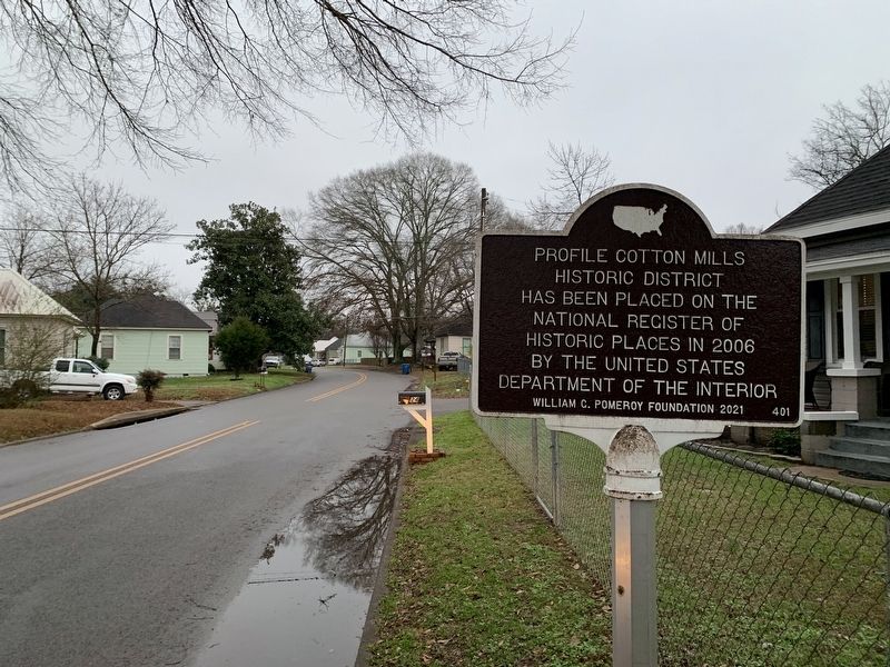
On A Street Southwest at G Avenue Southwest, on the left when traveling west on A Street Southwest.
Profile Cotton Mills Historic District has been placed on the National Register of Historic Places in 2006 by the United States Department of the Interior — — Map (db m195728) HM
On Ladiga Street Southeast at Church Avenue Southeast, on the right when traveling east on Ladiga Street Southeast.
John D. and Anna Maria Hoke founded the parish on June 30, 1844. Members of the Hoke, Forney, and Abernathy families joined over the years. The church design was based on Richard Upjohn's 1852 pattern book, Upjohn's Rural Architecture. Upjohn was . . . — — Map (db m199134) HM
On Ladiga Street Southeast at Chinabee Ave SE, on the right when traveling east on Ladiga Street Southeast.
Erected 1885.
Judge of Probate. A. Woods.
Commissioners, J.W. Anderson, A.M. Stewart, J.C. Watson, B.B. Nunnelly,
Architect & Builder
Joe. B. Patton.
Site of Calhoun County Court House destroyed by fire 1925 — — Map (db m267048) HM
On Ranch Road 0.1 miles east of Old Sulphur Springs Road, on the left when traveling south.
At this site, Robert Draper organized the first company accepted into the Provisional Army of the Confederate States from Calhoun County. The Sulphur Springs Greys, later the Calhoun Greys, were designated Company B of the 7th Alabama Volunteer . . . — — Map (db m271705) HM
Near Mountain Street Northwest west of Woodward Avenue Northwest.
The Depot was constructed in 1860 by the Selma, Rome and Dalton (GA) Railroad. It was used as a transfer and storage point for Confederate troops and materials during the War Between the States. — — Map (db m36443) HM
On Pelham Road North at Clinton Street Southwest, on the left when traveling north on Pelham Road North.
Since 1890 the financial interests of this area have been served by The First National Bank and its predecessor The Tredagar National Bank (an institution of the "Boom" days of Jacksonville)
Organizers were Peyton Rowan, President, Jos. . . . — — Map (db m29480) HM
On Pelham Road (State Highway 21) at 5th Street NE, on the right when traveling north on Pelham Road.
Prominent citizen of Jacksonville who served Alabama as Brigadier General, State Militia; member Legislature and Pres. of Senate; Circuit Court Judge; and Pres. Ala. and Tenn. Railroad
He owned extensive cotton plantations and mining interests . . . — — Map (db m29921) HM
On Ladiga Street Southwest at Gayle Ave SW, on the right when traveling east on Ladiga Street Southwest.
This Arkansas congressman and General had lived here (1833-1844).
Veteran of War with Mexico.
Elected to U.S. Congress in 1858 and 1860.
Served in Trans-Mississippi Dept. C.S.A as Brigadier General 1861-1862 served with Army of Tennessee . . . — — Map (db m267232) HM
On Public Square East (State Highway 21) south of Clinton Street Southeast, on the left when traveling north.
Brigadier General C.S.A.
With Army of Virginia 1861-1865.
Wounded in battle five times.
He was one of four distinguished sons
of Jacob Forney and Sabina Swope Hoke
of Jacksonville who held commissions
in the Confederate Army.
. . . — — Map (db m36480) HM
On Janney Road 0.1 miles east of Spring Road, on the left when traveling east.
The furnace was constructed by Montgomery businessman Alfred A. Janney, reportedly using slaves brought from Tennessee by a "Dr. Smith." The furnace was completed and ready to produce pig iron when, on July 14, 1864, a Union cavalry raiding force of . . . — — Map (db m25544) HM
The Archaic period covers a vast expanse of time (8,250 years).
Many changes occurred during the Archaic period. For
example, the climate and vegetation that Early Archaic people
saw was much different than the climate and vegetation that
Late . . . — — Map (db m160554) HM
In 2007, the City of Oxford began planning what is today known as
Choccolocco Park. Discoveries at the site identified the presence of the
humans inhabiting this land as early as 10,000 years ago. Oxford undertook
an archaeological investigation . . . — — Map (db m144980) HM
Boiling Springs Road once provided a vital transportation link
across Choccolocco Creek for residents of the valley. The road
received its name from the Boiling Spring (pictured below and to
the right) located across the creek at this location. . . . — — Map (db m145023) HM
Choccolocco Park is located on land that was farmed by the Caver,
Christian and Davis families from 1840 until the late twentieth
century. During the Great Depression, the farm was documented
by the Historic American Building Survey. The subjects . . . — — Map (db m145025) HM
When workers began excavating the lake for Choccolocco Park, they
uncovered several large charcoal-filled ditches that formed circles.
Archaeologists investigated these features and determined that these
were the remains of 19th century charcoal . . . — — Map (db m144947) HM
Near Recreation Drive east of Mc Cullars Lane, on the left when traveling east.
was moved on August 17 , 1990 to Oxford Lake
Leon Smith, Mayor
City of Oxford Councilmembers
Johnny Austin • Johnny Bentley • Bruce Dempsey
Norma Martin • Marshall Shaddix
The bridge was donated to the City of Oxford
by the . . . — — Map (db m198533) HM
On Main Street at Mc Kibbon Street, on the right when traveling north on Main Street.
[Top plaque]
This property has been
placed on the
National Register
of Historic Places
by the United States
Department of the Interior
[Bottom plaque]
301 Main Street
has been placed on the
Alabama Register
of . . . — — Map (db m217258) HM
On Main Street south of East Oak Street, on the right when traveling north.
A Memorial to
Gen. Andrew Jackson,
the Tennessee Patriots,
the Alabama Patriots, and
pioneers who by their
courage and fortitude in
1813 - 1814, won five successful
battles in the Creek Indian
Campaign.
Side . . . — — Map (db m106593) HM
Near Recreation Drive east of Mc Cullars Lane, on the right when traveling east.
Seaman Second Class, United States Navy, George Washington Ingram was killed in action in the defense of Pearl Harbor on December 7, 1941.
For Seaman Ingram's bravery, an American destroyer was built and named in his honor. The U.S.S. George W. . . . — — Map (db m217252) HM WM
On Main Street at East Oak Street, on the right when traveling north on Main Street.
First incorporated as a town, February 7, 1852, in Benton County, Oxford's second incorporation was approved February 21, 1860 in Calhoun County. Long before this territory was “settled”, it was inhabited by Creek Indians. In the time . . . — — Map (db m106589) HM
Near Recreation Drive east of Mc Cullars Lane, on the right when traveling east.
Great citizen, eminent lawyer, valiant soldier, renowned statesman, diplomat, Christian gentleman. Near this spot, 1862, he mustered into service 51 Ala. Regt. Cavalry, Army Confederate States of America. Ala. U.S. Senator, 1877 until his death. . . . — — Map (db m217250) WM
The Mississippian inhabitants of Choccolocco were skilled
agriculturalists who grew corn, squash and beans in addition to
the many wild plants that they harvested. Archaeologists
working here have found the remains of many of these plants in
the . . . — — Map (db m144950) HM
During the Mississippi period earthen mound construction
resumed at Choccolocco. Mound building was a community
effort and these earthen constructions served as the center of
community life for large towns like the one depicted at right.
This . . . — — Map (db m144936) HM
Welcome! We are the Arbeka (Abihka). This is the ceremonial
ground of our ancestors who once called this valley their home.
When the Arbeka (Abihka) were forced to remove to Oklahoma
they carried the sacred fire from this place to their new home. . . . — — Map (db m144923) HM
The ancestral traditions of the Muscogee (Creek) Nation are still practiced
today. Among these is a game called “Little Brother of War" or "stickball”.
The game is used to settle disagreements, to toughen warriors and
sometimes for . . . — — Map (db m144938) HM
By AD 1730, the English, French and Spanish had all established colonies
in the region. It was also around this time that the people within the
Coosa, Tallapoosa and Chattahoochee Valleys, known to history as the
Arbekas (Abihkas), Tallapoosas, . . . — — Map (db m145022) HM
On Mc Cullars Lane east of Recreation Dr, on the left when traveling east.
Oxford Lake, since the 1800's, has been the social & recreational center for this area. In the 1900's there was horse racing, boating, & a trolley line that brought visitors to the park. In the 1930s the lake had an amusement park. This site was . . . — — Map (db m261791) HM
The people living during the Paleoindian period experienced a
world very different from that we know today. These people
lived during the last ice age when large mammals still roamed
North America. Archaeologists sometimes refer to these . . . — — Map (db m144948) HM
The stone mound here once sat on nearby Signal Mountain and is now
understood to be part of a much larger cultural landscape. Working with
the Muscogee (Creek) Nation and the people of the Arbeka (Abihka)
Ceremonial Ground, archaeologist Robert . . . — — Map (db m144927) HM
On Main Street south of East Oak Street, on the right when traveling north.
The town of Oxford was first incorporated by the Alabama legislature in 1852. The original boundaries included a one square mile area enlarged in 1860. Oxford became active as a cotton and trading center but during the Civil War growth slowed, and . . . — — Map (db m106591) HM
The arrival of European explorers and colonists in North
America disrupted the Mississippian world in ways that
researchers are still working to understand. Spanish
explorer Hernando de Soto arrived in the interior in AD
1540. He traveled . . . — — Map (db m144973) HM
Centered around Boiling Spring, the Choccolocco Creek Archaeological Complex once consisted of at least three earthen mounds, a large stone mound, and a large snake effigy (representation) also made of stone. The largest earthen mound once stood . . . — — Map (db m144926) HM
On McKibbon Street 0.1 miles west of Ross Street, on the right when traveling west.
Located at the end of McKibbon Street is on a cedar covered hill with a beautiful view. The cemetery contains the remains of many of Oxford's early settlers. Some markers date in the 1850's. — — Map (db m195727) HM
Today, the people who once inhabited this region of Alabama are recognized
by the federal government as belonging to several tribes: the Muscogee
(Creek) Nation, Alabama-Quassarte Tribal Town, Kialegee Tribal Town, and
Thlopthlocco Tribal Town of . . . — — Map (db m144937) HM
{Timeline from 12,500 BC to AD 1979}
Creek Chiefs During the Removal Period
Selocta, Chinnabee, Soletawv Cetto Yupe, Horned Snake Soldier
Opothle Yahola
Menawa
William McIntosh — — Map (db m145089) HM
The interpretive trail winds through what was once the 19th century
Muscogee (Creek) Nation town of Choccolocco. Archaeologists have
found evidence that Native Americans began coming to this place about
8,000 BC and the establishment of long-term . . . — — Map (db m145097) HM
Woodland period people established permanent communities
within a climate and forest that was very similar to that
experienced by today's residents of the Choccolocco Valley. By
AD 100, the residents had started constructing the earthen
mound . . . — — Map (db m144977) HM
On East Ladiga Street east of North Center Avenue, on the right when traveling west.
Cross Plains citizens voted for incorporation March 10, 1871. A second vote was cast for reincorporation May 15, 1882. By the acts of the Alabama Legislature of 1888, Cross Plains became Piedmont September 30, 1888. Mayors for both Cross Plains . . . — — Map (db m272389) HM
On North Center Avenue at Southern Blvd, on the right when traveling south on North Center Avenue.
Cross Plains citizens voted for incorporation March 10, 1871. A second vote was cast for reincorporation May 15, 1882. By the acts of the Alabama Legislature of 1888, Cross Plains became Piedmont September 30, 1888. Mayors for both Cross Plains and . . . — — Map (db m272390) HM
On Seaboard Blvd at S Center Ave, on the right when traveling east on Seaboard Blvd.
Originally the Dixie Hotel was the Dixie House, operated by Mrs.
Martin Tyler Ledbetter from 1910-1916. Traveling salesmen were
regular guests as well as local residents who boarded the train at
the Hotel. Mrs. Ledbetter set a table with a . . . — — Map (db m285145) HM
On East Ladiga Street at Mc Farland Ave, on the right when traveling east on East Ladiga Street.
Hiram Dugger came to Benton County, Alabama, in 1832 from Carter County, Tennessee, before the Indians were removed to the west. He worked a year for Joseph Nolen before marrying Mr. Nolen's daughter, Zanna. The couple moved to the base of the . . . — — Map (db m270859) HM
On East Ladiga Street, on the left when traveling west.
The First Presbyterian Church of Piedmont was organized March 18, 1890, with seventeen charter members, by Rev. B. F. Bedinger, Presbyterian evangelist. Rev. J. E. McLean was the first minister. First elders were C. W. McMahon and Stephen Ferguson; . . . — — Map (db m27993) HM
On North Main Street at Alabama Street on North Main Street.
Beginning as a Methodist mission in the 1850's, the Piedmont First United Methodist Church was organized in 1867 as the Cross Plains Methodist Episcopal Church, South, by Wilson Johnson and a small band of local Methodists. In 1868 a small church . . . — — Map (db m308073) HM
On North Center Avenue at Front Street East on North Center Avenue.
The Alabama Tennessee River Railroad was chartered by the Alabama legislature in the session of 1836-1837. Work was begun at Selma in 1851 and the rails reached Blue Mountain in 1861. Work was terminated during the War Between the States.
In . . . — — Map (db m27995) HM
On Southern Boulevard west of N Center Ave, on the right when traveling west.
Major Jacob Forney Dailey was an early pioneer settler and the first mayor of Cross Plains (1871-1874). He built this home around 1880 as a wedding gift for his daughter Mary Catherine, who married Alexander McCollister, mayor of Piedmont . . . — — Map (db m270594) HM
On North Main Street at W Ladiga St, on the right when traveling south on North Main Street.
The First Baptist Church, in the early years being known as Piedmont Baptist Church, was organized in 1870.
The first church building was a white frame building located at 202 Daily Street and in 1905 moved to a new building at the corner of . . . — — Map (db m272381) HM
Near Museum Drive north of Regar Circle, on the left when traveling north.
Dedicated Oct. 15, 1980 and given in memory of those members who gave their lives in World War I & II by the 27th. Division Association whose members trained on this ground 1940-1941 — — Map (db m53009) HM
On Martin Luther King Drive (County Road 83) at County Road 82, on the right when traveling south on Martin Luther King Drive.
Following the signing of the Creek Treaty in 1832, the early white settlers constructed a 16 by 30 foot hand hewn log fort for protection against a possible Indian uprising from Cussetaw Indian Village on Osanippa Creek just north of here. Walls of . . . — — Map (db m71643) HM
On County Road 388 at County Road 267, on the right when traveling west on County Road 388.
Pat Garrett and Billy the Kid
As sheriff of Lincoln County, Pat Garrett was charged with tracking down and arresting Billy the Kid, a friend from Garrett's saloon keeping days in Fort Sumner, New Mexico. He was captured in December 1880 . . . — — Map (db m83262) HM
On U.S. 431 at County Route 222, on the left when traveling south on U.S. 431.
On a hill one-half mile east of U.S. Highway 431 stood the original Five Points High School. The imposing brick building had two floors above a full basement and a large auditorium that seated 400 people. Erected in 1916, it stood amidst an 18-acre . . . — — Map (db m195786) HM
On U.S. 431 0.1 miles south of County Route 222, on the right when traveling south.
In 1885, Five Points was named because of five roads converging at a single point. Before this, the post office was known as Lystra, operated by Postmaster W.C. Smith. The town was incorporated in 1915, making the town Chambers County's oldest . . . — — Map (db m195788) HM
On 5 Points Fredonia Road (County Road 222) east of County Road 267, on the right when traveling east.
From its foundation, Fredonia was the educational and trade center for northeast section of Chambers County. "The Southern Military Academy" was established in the village by the state legislature and forced to close by the civil strife. Sixteen . . . — — Map (db m197957) HM
Near County Road 267 0.8 miles north of County Road 216, on the left when traveling north.
The Rosenwald School program was a collaboration
between educator Booker T. Washington and Sears
CEO Julius Rosenwald to improve educational
opportunities for African American children in
the rural South during the early 1900's. The
Rosenwald . . . — — Map (db m238815) HM
On Lafayette Street North (U.S. 431) at 1st Avenue Southwest, on the right when traveling north on Lafayette Street North.
World Heavyweight Champion
1937-1949
Born May 13,1914
Chamber County, Alabama
Died April 12,1981
Buried Arlington National Cemetery
Arlington, Virginia
"The Brown Bomber"
"Joe Louis is a credit to his Race… The . . . — — Map (db m197976)
On Lafayette Street North (U.S. 431) just south of Alabama Avenue, on the right when traveling north.
Chambers County, created December 18, 1832 from Creek Indian cession. Named for Dr. Henry C. Chambers of Madison County, member of Constitutional Convention 1819, legislature of 1820, elected U.S. Senator 1825 but died enroute to Washington.
. . . — — Map (db m18162) HM
On 1st Street SE at 7th Street SE, on the left when traveling south on 1st Street SE.
On September 29, 1919, Chambers County Training School
opened its doors for African American students.
The year before, a local African American educator
and merchant, C. Neal Finley, wrote an appeal to the
"white citizens of LaFayette and . . . — — Map (db m238831) HM
On Lafayette Street (U.S. 431), on the right when traveling north.
In Memory of
Chambers Co. Veterans
Who Gave Their Lives
In Following Wars
World War II
Askew, Arthur L. Pvt. • Austin, George L. Jr. 1st Lt. • Baker, Edwin H. Sgt. • Bassett, Wilma M. Pvt. • Belcher, Guy E. PFC. • Bishop, Ulysses . . . — — Map (db m18163) WM
On B Street 0.4 miles south of 2nd Street SW, on the right when traveling south.
Elisha and Essie Handy came to La Fayette in 1925. They were
educators and active in civic and religious activities. In 1940 their
oldest son, Ralph, died from tuberculosis and was buried in the
only cemetery in La Fayette for African-Americans . . . — — Map (db m151220) HM
On Southeast Avenue A (County Route 50) 0.1 miles east of Southeast 3rd Street, on the right when traveling east.
LaFayette Cemetery, also known as Westview, began in 1934 with the death of Miss Sarah Gipson. Many early pioneers and veterans of East Alabama are buried here including Revolutionary War Patriot Capt. Alexander Dunn, Col. Charles McLemore, . . . — — Map (db m83263) HM
On 1st Street Southeast at 2nd Avenue Southeast, on the right when traveling north on 1st Street Southeast.
This structure was built by early settlers from Virginia, Tennessee, and the Carolinas, and subsequently modified. The original building has stood since 1836.
Union Sunday School begun here in 1891. Many eminent ministers have filled the . . . — — Map (db m83264) HM
On B Street at 1st Place SW, on the right when traveling north on B Street.
Vines Funeral Home and Ambulance Service was established in 1952
and is representative of a mid-20th century rural African American
funeral home. It is the only funeral home in Alabama still operating
an ambulance service. The main building of . . . — — Map (db m151221) HM
On North Lanier Avenue at 1st Street, on the left when traveling north on North Lanier Avenue. Reported permanently removed.
Known as Bluffton from about 1835-1893. Bluffton was incorporated in 1865. Name changed to Lanett, town of Lanett incorporated 1893. Its charter was approved in 1895. Early records mention academies, two near this site. The Presbyterian Church was . . . — — Map (db m92061) HM
On State Line Road (County Route 212) 0.1 miles south of North State Line Road, on the right when traveling north.
A flourishing, ancient town of the Muscogee Indians known as Ocfuskooche Tallahassee (Old Town) stood on this site. English traders from Charles Town visited it about 1685. A trail known as "Old Horse Path" led from this village to the Tallapoosa. . . . — — Map (db m36315) HM
On Country Club Road 1.6 miles west of County Road 210, on the left when traveling west.
Side 1
Providence Baptist Church was organized before 1836 by Elder Francis Calloway. It was one of the ten charter churches of the East Liberty Baptist Association. The small white frame church was built during the ministry of Reverend . . . — — Map (db m83265) HM
On North Lanier Avenue at 1st Street on North Lanier Avenue.
Bluffton was the name of a village adjacent to West Point, Georgia in Chambers County, Alabama. Bluffton was incorporated as a town by an Act of the Alabama Legislature and approved February 20, 1866. It is not known who gave it the name of . . . — — Map (db m295585) HM
On U.S. 431 near County Road 23, on the right when traveling north.
Near this site stood the Oak Bowery Female Institute,
opened in 1849 under auspices of the Methodist church. Masons
established the East Alabama Masonic Institute for Young Men
Among Oak Bowery's noteworthy citizens:
William J. Samford. Alabama . . . — — Map (db m151222) HM
On California Road at Middle Street, on the left when traveling north on California Road.
The church was founded by Elder
J.A. Branch with thirteen charter
members. From its beginning, the
church has striven to live, teach
and preach Christianity. The church
building was built circa 1870.
Given in memory of Annie Love . . . — — Map (db m304290) HM
On Boulevard at Scott Street, on the right when traveling south on Boulevard.
Side 1
Built 1916 by West Point Mfg. Co. and called Fairfax “Union” Church as it was shared by Disciples of Christ, Methodist, & Baptist groups. It was purchased by the Disciples of Christ after the others left to build their . . . — — Map (db m83266) HM
On Boulevard at Combs Street, on the right when traveling south on Boulevard.
Built in 1916, the kindergarten was one of five original public buildings in the Fairfax Mill Village. Each mill village had an efficient, attractive, and well kept kindergarten for children ages four to six. LaFayette Lanier, Sr. was the . . . — — Map (db m71634) HM
On Hopewell Road 0.2 miles east of Ben Brown Road, on the right when traveling east.
In 1853 James E. Chambers donated 3-acres of land
on the Collins Ferry-Oakbowery Road for Hopewell
Church and Cemetery. The first building here was
crude with split log benches. It was replaced in the
1880's by one built by James B. Chambers & . . . — — Map (db m304111) HM
On Cherry Drive at North 13th Avenue, on the right when traveling west on Cherry Drive.
The school was located at three different sites on Cherry Drive. Its beginning was in The Blue Hall Building adjacent to Goodsell Methodist Church. Later it was moved to the Dallas/Jackson Home and became the Jackson Hill School. In 1921, George H. . . . — — Map (db m71638) HM
On 20th Avenue (U.S. 29) 0.1 miles north of 61st Street West, on the right when traveling east.
Cornerstones of Chattahoochee Mfg. Co., Langdale, Ala., and Alabama & Georgia Mfg. Co., River View, Ala., were laid on August 1, 1866. Mills used Chattahoochee River water power for operation of spindles and looms. Planters and businessmen of . . . — — Map (db m71637) HM
According to Joseph L. Lanier, "The cotton textile industry came to
East Alabama, in the valley of the Chattahoochee River, in 1866,
soon after Appomattox. Two separate groups of local planters and
merchants took stock of their ruined . . . — — Map (db m297194) HM
On County Road 251 0.1 miles north of County Road 714, on the right when traveling north.
Dedicated to the memory
of all our servicemen
who were in the
Revolutionary War 1775-1783
War with Great Britain 1812-1814
Indian wars - various 1813-1837
War with Mexico 1846-1848
War Between the States 1861-1865
Spanish-American . . . — — Map (db m156266) WM
The Confederate States of America in 1862 commissioned the Noble Brothers of Rome, Georgia to erect a cold blast furnace to produce needed pig iron for the war effort.
The skilled labor was detailed from Confederate army personnel. It is . . . — — Map (db m83267) HM
On County Road 251 0.1 miles north of County Road 714, on the left when traveling north.
Built in late 1862 by the Noble brothers, Cornwall Furnace was named for a similar blast iron furnace in James Noble's home state of Pennsylvania. The pig iron ingots produced from this facility were taken to the Noble Foundry in Rome where they . . . — — Map (db m156264) HM
On County Road 251 0.1 miles north of County Road 714, on the right when traveling north.
The furnace was constructed 1862-1863 by the Nobles Brothers Foundry from Rome, GA using financing from the Confederate States of America. Slave labor was used to dig a half mile canal upstream to the Chattooga River, which powered the airblast. A . . . — — Map (db m156261) HM
On Alabama Route 273 at County Route 275, on the right when traveling south on Alabama Route 273.
Gen. Hood, commanding the Dept. of Tennessee and Georgia for the Confederate Army, made his headquarters in this house on Oct. 19, 1864 on his retreat from Atlanta to Tennessee via Gadsden. His army numbered approximately 40,000 troops. — — Map (db m116615) HM
On Old Alabama Route 9 west of Sewell Ferry Road, on the right when traveling west.
This general area is believed to be the site of the Indian village of Costa visited by DeSoto July 2, 1540. The very old cedar trees may have been here at that time. They are some of the largest in the Southeast. These cedars are among the . . . — — Map (db m114988) HM
On County Road 92 0.3 miles east of County Road 585 when traveling east.
Constructed around 1875 by John Seaborn Watt for his bride, Emma Chastillette Williamson, this fine example of Victorian architecture was originally located near Yancey's Bend prior to the construction of Weiss Lake. The site was going to be . . . — — Map (db m137844) HM
On Cedar Bluff Road at West Main Street (Business U.S. 411), on the right on Cedar Bluff Road.
Area 575 square miles. Aborigines inhabited area 4000 B.C. Cherokee and Creek Historic Indians about 1300-May 1838. Hernando De Soto-First white man July 1540. First white settlers about 1810 from VA, NC, SC, GA, and Tenn. Formed Cherokee Cession . . . — — Map (db m133321) HM
On Cedar Bluff Road (State Road 283) north of West Main Street (Business U.S. 411), in the median.
The current courthouse is the fourth to be built on this site. The first courthouse, constructed of brick in 1849, burned in 1882. A second brick courthouse was built that year and it only lasted 13 years before it burned in 1895. The third brick . . . — — Map (db m114838) HM
On East Main Street (Business U.S. 411) at Cedar Bluff Road, on the left when traveling east on East Main Street.
In November 1958, Col. Robert E. Mann and a small group of interested residents organized the Cherokee County Historical Society in Cedar Bluff with a goal to initiate the preservation of the history of Cherokee County. Over the following years, the . . . — — Map (db m261855) HM
On East Main Street (Business U.S. 411) at Iris Drive, on the right when traveling west on East Main Street.
In honor of those men and women who fought for the
cause of freedom and in memory of those who paid the
ultimate price and or did not make it back home
World War I • World War II • Korea • Vietnam • Desert Storm
This war memorial . . . — — Map (db m197522) WM
On Cedar Bluff Road (State Road 283) north of West Main Street (Business U.S. 411), in the median.
This area had long been home to the Cherokee Indians and the first white settlers did not arrive until the early 1800's. On December 29, 1835, the Cherokees signed a controversial treaty surrendering their lands here to the U.S. Government. A short . . . — — Map (db m114840) HM
On College Street (Route 20) 0.1 miles south of South River Road, on the right when traveling north.
Final resting place of Chief Pathkiller (B. 1749 - D. 1827) who served as principal chief of the Cherokee Nation. Many prominent early settlers are also interred here including newspaper editor and publisher, Confederate infantry captain and . . . — — Map (db m114282) HM
On Jackson Drive east of Bay Springs Road, on the left when traveling east.
Hatcher School was created as a result of the dreams and sacrifices of the people of the community. Black children in Centre had to travel to Cedar Bluff to attend school. The State purchased land and citizens of the community provided funding and . . . — — Map (db m133323) HM
On South River Street south of 2nd Street, on the left when traveling south.
This house was built in 1846 by George Walden soon after the town of Centre was laid out. The house was occupied by Judge Wm. Lafayette Whitlock who was a lawyer, delegate to the 1861 Secession Convention and judge of the 12th judicial district. . . . — — Map (db m120047) HM
On West Main Street (Business U.S. 411) at Tol Street, on the right when traveling west on West Main Street.
Inventor of the early typewriter—the pterotye. Born in 1831, Union Dist., S.C., died in 1905, grave 2 miles west. While registered in chancery and later editor of the National Democrat near this siteabout 1860, developed his first writing . . . — — Map (db m115571) HM
The McClung brothers, J.B. and Thomas, homesteaded land on Johhny's Creek in the 1800s. The two brothers harnessed power from water that flowed over the falls to operate a sawmill and grist mill. The McClung's two mills and blacksmith shop played . . . — — Map (db m212844) HM
On East Main Street (Business U.S. 411) at Cedar Bluff Road, on the left when traveling east on East Main Street.
Jordan Big Store
has been placed on the
Alabama Register of
Landmarks & Heritage
by the Alabama
Historical Commission
August 10, 2017 — — Map (db m114746) HM
On West Main Street at Watson Drive, on the right when traveling west on West Main Street.
Mose Hampton bought his freedom prior to the Civil War. He was a builder, assisted in laying out and surveying the town of Centre, a minister in the Episcopal Methodist North, and an inventor. Mr. Hampton owned land in the vicinity of this marker on . . . — — Map (db m120046) HM
On East Main Street (Business U.S. 411) at Iris Drive, on the right when traveling east on East Main Street.
Dedicated on November 19, 1948 has been listed in the Alabama Register of Landmarks and Heritage by the Alabama Historical Commission June 27, 2019 — — Map (db m181355) HM
479 entries matched your criteria. Entries 101 through 200 are listed above. ⊲ Previous 100 — Next 100 ⊳