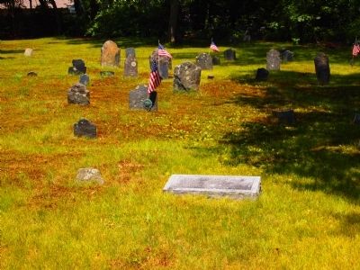
Site of "The Palmer's River Meeting House" The first meeting house in the second precinct of Rehoboth. Construction started in 1717 and completed November 29th 1721, with Reverend David Turner as pastor. Fifty pounds was donated towards the cost of . . . — — Map (db m55662) HM
Somerset Remembers
1917 1918
These Sons and Daughters Who Served their Country
And Humanity in the World War
Adamson, Thomas · Almy, Albert B · Almy, Israel T · Auclair, Amos J · Babbitt, Leon P · Banville, Edme F · Beaulieu, Reginald J . . . — — Map (db m208878) WM
Erected
In Honor of Our
Country’s Defenders
and Dedicated to
Those
who made the
Supreme Sacrifice
James L. & John E. Lynch
Post 8500
Somerset, Mass.
May 30, 1951 — — Map (db m208829) WM
United States Army
Phillip Y. Adams · John Arruda · Antonio S. Borges · Rodman P. Bowker · Irving F. Brown Jr. · Sheldon I. Clarkson · James P. Davis · Arthur J. Gagnon · Antone C. Lima · John E. Lynch · Stuart C. Manchester · William R. Snyder · . . . — — Map (db m208876) WM
Dedicated to the Memory of
Henry C. Cousineau EOI U.S.N.R.
Killed In Action
Jan. 4, 1968 Tam Ky Danang South Vietnam
Veteran of World War II
Volunteer for Duty in Vietnam
This Tablet Erected by Family and
Townspeople of Swansea, Mass. . . . — — Map (db m160353) HM WM
King’s Rock, spanning 200 ft. along today’s Warren/Swansea border, was a significant location along the route and an important place for tribal gatherings under Metacom’s older brother, Wamsutta. Tribes from all over New England were known to have . . . — — Map (db m301437) HM
Near this spot stood the John Myles Garrison House. The place of meeting of the troops of Massachusetts Bay and Plymouth colonies.
Commanded by
Majors Thomas Savage and James Cudworth, who marched to the relief of Swansea at the opening of . . . — — Map (db m299489) HM WM
Operations Desert Shield - Desert Storm
August 2, 1990 – April 11, 1991
In Honor of the Swansea Men and Women
Deployed to Serve in the Persian Gulf War
SP4 L. Rudy Arruda, Jr. · ABH3 David W. Archer · LCPL Todd C. Baptista · PFC Eric . . . — — Map (db m160351) WM
Here were built about 200 ships from small sloops to vessels of 1060 tons which sailed from the Atlantic coast to the China seas.
Dedicated to their memory by
Algernon H Bell •
Carolyn Bell Fenley •
Constance Bell Falconer — — Map (db m56214) HM
1917 Roll of Honor The World War 1918
This Tablet Is Erected
By the Town of Swansea
In Honor of its Citizens
Who Served Their Country in the World War — — Map (db m160358) WM
Dedicated to the
Vietnam Veterans
by
Swansea's Veterans Council
Veterans of Foreign Wars
American Legion
Citizens
November 11,1983 — — Map (db m160355) WM
( names on the granite benches )
Frank Joseph Sawejko USN · Colonel Antone S. Agular, Jr. · Horace A. “Hap” Pelletier USN · Capt. John A. Burke, Jr. USN — — Map (db m160348) WM
In 1653 settler-colonists laid claim to "Sowams," the ancestral home of the Pokanoket. Though the Pokanoket never relinquished their claim, settler-colonists soon occupied the land, including modern-day Barrington. Among these settler-colonists were . . . — — Map (db m251628) HM
Early Plymouth colonists called Barrington "The Garden of the Colony" for its beautiful location on Narragansett Bay and the Providence River, its numerous streams and meadows, and its fertile soil.
- from Bicknell, A History . . . — — Map (db m304528) HM
"Campers all helped each other pitch tents, which had a big pole in the middle. The tents were up all summer long and Labor Day, down they'd come. There would be at least a hundred of them."
- Mary Clare Feeley, a summer . . . — — Map (db m251860) HM
In 1847, Nathaniel Potter of Providence founded the Nayett Brick Company along the nearby banks of Mouscochuck Creek and what was then a large swamp. Making bricks involved digging clay by hand with picks and shovels from holes 12 to 14 feet in . . . — — Map (db m251635) HM
Prince's Hill, the highest point of land in Barrington, was named for its original colonial owner, Governor Thomas Prince, or Prence, of Plymouth Plantation. Around 1728, the town bought a half-acre of land on this hill for Prince's Hill . . . — — Map (db m251626) HM
A family of shipbuilders, seafarers, and farmers, the Drowns settled in Bristol and Warren before the American Revolution. In the late 1700s, Jeremiah Drown began buying land in Barrington, and, in 1833, his son Alfred purchased 16 acres here . . . — — Map (db m251862) HM
Platted
1868
Welcome to
Drownville
Farmland once owned by the Drown family, and the land was subdivided after passenger rail service was established in 1855, connecting Barrington to Providence.
Listed on the
National . . . — — Map (db m251908) HM
Once known as the Humphrey Farm, Haines Memorial State Park (originally named the Dr. George B. Haines Memorial Park) is a picturesque stretch of fields, woods, and coastline in Barrington and the Riverside section of East Providence. Dr. Haines, . . . — — Map (db m251859) HM
The Willis E. Blount Ice Company was created circa 1918 on Little Echo to provide ice for the Warren-based Blount Oyster Company. The pond, a flooded claypit, had been used for ice harvesting since the late 1800s. Willis' sons, Luther and Francis . . . — — Map (db m251909) HM
This Boulder Marks the site of Massasoit Spring and commemorates the great Indian sachem Massasoit, friend of the white man and chief of this region when the Pilgrims landed at Plymouth, 1620.
This tablet is placed in accordance with the . . . — — Map (db m290544) HM
"When workers were building the Barrington Bridge in 1914, my grandmother, Maria Balia, who lived nearby would serve them drinks that she kept cold in her well. The workers used to go to her house every day and sit under the grape . . . — — Map (db m304538) HM
Osamequin Nature Preserve and Bird Sanctuary is named in honor of the Massasoit (Great Leader) Osamequin (or Ousamequin) of the Pokanoket Tribe. Osamequin, which means Yellow Feather, led his people in helping the settlers of the Plymouth Colony . . . — — Map (db m282075) HM
"I remember the spectacular view of the Barrington River in the Spring and Summer; the boats were moored in the beautiful harbor which gave the police access to our community from both land and water."
- Police Officer Joseph . . . — — Map (db m223004) HM
This monument is here to remind us of all who served, in whatever capacity, in whatever place, the men and women of the Army, Navy, Air Force, Marines and Coast Guard.
Dedicated to Barrington veterans WWII "Operation Silent Witness" . . . — — Map (db m251630) WM
A Conservation Success Story - Sowams Woods is a 12.3 acre parcel owned and managed by the Barrington Land Conservation Trust. It took four years, two-million dollars and a far-reaching coalition to protect the property forever. The effort . . . — — Map (db m283199) HM
A memorial of patriotism and a tribute of honor to the men of Barrington who in the World War served their country 1914 - 1918
Domenico Acciardo •
Giuseppe Acciardo •
Earl Adams •
G. Edward Anderson •
Gustaf O. Anderson . . . — — Map (db m252317) WM
In memory of the members of this parish who made the supreme sacrifice in World War II
1941 - 1945
Anthony Carlone •
Frank Chianese •
Amos Cabral •
Roland O. Cusson •
John DiCicco •
Peter D'Elia •
James Paolella •
Constantino . . . — — Map (db m251636) WM
The Mount Hoge Bridge was immediately heralded as a triumph of engineering and remarkably beautiful structure. Steinman had began with an inherently graceful bridge form and then given special attention in the artistic design of the entire . . . — — Map (db m186854) HM
Named in honor of
Raymond Earl Bliven
Corporal 16th Co. 5th Regt.
U.S. Marine Corps
Born August 5 1897
Killed in Action in France
June 23 1918 — — Map (db m222947) WM
The Mount Hope Bridge was built as a private toll bridge by the Mount Hope Bridge Co. after state proposals for a public bridge were defeated. In 1927, Dr. David B Steinman, the noted New York bridge engineer, produced the design for a graceful . . . — — Map (db m186853) HM
World War I •
World War II •
Korean War •
Vietnam War •
Miscellaneous Conflicts •
Persian Gulf •
World War II •
Korean War •
Vietnam War •
Afghanistan •
Iraq •
Combat Merchant Marines
Oath of . . . — — Map (db m222954) WM
In appreciation of the US Coast Guard who have served their country and the State of Rhode Island and the Town of Bristol since 1935 — — Map (db m222756) HM WM
In January 1680, following King Philip’s War, Plymouth Colony sold the area “known by the name of Mount Hope Neck and Poppasquash Neck”, which was part of Sowams, the ancestral home of the Pokanoket Tribe. Following the sale, four wealthy Boston . . . — — Map (db m186127) HM
The Bristol Rainkeep
Mrs. Perry's Garden in Thomas Park had no water source and no electrical power, so providing consistent, reliable moisture for plants here was difficult. The Bristol Rainkeep provides a sustainable solution to . . . — — Map (db m311816) HM
Organized and first church edifice built on Bristol Common 1683. Oldest Congregational church in Rhode Island. Second church building erected 1784. This building erected 1856. — — Map (db m222915) HM
Erected in memory of the stalwart founders and builders of Bristol those courageous men and women whose dauntless spirit and renowned achievements have become the everlasting heritage of this town — — Map (db m222923) HM
Finney's Distillery was discovered during demolition of the structure of the original Bank of Bristol (shown below, center). For nearly thirty-five years, two hundred gallons of rum were made each day. The rum was placed in barrels called . . . — — Map (db m222816) HM
In 1675, after King Philip's War, the lands known as Mount Hope were ceded to Plymouth Colony. Plymouth sold the area that became the Town of Bristol and its deep water harbor to four proprietors, who laid out streets relative to the waterfront. . . . — — Map (db m222772) HM
Today, Bristol's waterfront embodies the town's many successful efforts to repurpose its maritime-related resources and structures. The creation of the Bristol Waterfront Historic District in 1975 encouraged residents to work actively towards . . . — — Map (db m222783) HM
With the collapse of the DeWolf empire in 1825, Bristol's golden years came to an abrupt halt. Although the maritime economy would eventually rebound, it would never reach the plateau it had known prior to 1825. By the 1830s, new pressures on . . . — — Map (db m222828) HM
In Bristol's early years, the waterfront was an important means of transportation. In addition to ships engaged in the trans-Atlantic merchant trade, smaller boats ferried people and goods around both Narraganset Bay, and beyond to cities like . . . — — Map (db m222836) HM
After the Civil war, Bristol's economy shifted to the production of rubber goods. In 1865, August O. Bourn established the National Rubber Company on Wood Street and began manufacturing rubber using vulcanizing technology, which had been recently . . . — — Map (db m222849) HM
Flood awareness is important to Bristol's community of residents, businesses and visitors. These historic photos depict the destruction to the town from the 1938 and 1954 Hurricanes.
❶ The D'Wolf Inn stood on this . . . — — Map (db m222764) HM
Flood awareness is important to Bristol's community of residents, businesses and visitors. These historic photos depict the destruction to the town from the 1938 Hurricane.
In 1818 James DeWolf and his brother built the DeWolf Warehouse. The DeWolf family engaged in numerous sea-related enterprises that included the slave trade, rum distilleries, privateering, merchant marine, insurance, banking and Cuban sugar and . . . — — Map (db m222814) HM
Liberty Tree Memorial
This American Liberty Elm was named after "The Liberty Tree
Our Country's first Symbol of Freedom." On the morning of
August 14, 1765, the people of Boston awakened to discover two
effigies suspended from an elm tree in . . . — — Map (db m306036) WM
In grateful recognition of the veterans of Bristol Rhode Island who gave their lives to defend the liberties of the world
~ In memory of ~
Almeida, Anthony •
Barboza, Joseph •
Barboza, Manuel M. •
Barron, Robert K. • . . . — — Map (db m222893) WM
Memorial to
Bristol Naval Veterans
Originally dedicated
Victory Day Aug. 13, 1979
Rededicated Nov. 11, 1993
Bristol Veterans Council — — Map (db m311756) WM
Mount Hope (originally Montaup in the Pokanoket language) is a wooded promontory on the eastern shore of Bristol, Rhode Island overlooking the part of Narragansett Bay known as Mount Hope Bay. Before the European settlers arrived in New England, . . . — — Map (db m301431) HM
Connecting Providence plantations settled by Roger Williams 1636 with the island of Rhode Island settled by John Clarke 1638 (purchased from the Indians and originally called Aquidneck)
On the nearby shores of Mount Hope lived the Wampanoag . . . — — Map (db m305879) HM
This Red Maple Tree is planted by the Rhode Island Semiquincentennial Commission in commemoration of the 250th anniversary of the founding of the United States of America in 2026. Like the original 18th century Liberty Trees - symbols of . . . — — Map (db m311729) HM WM
This Federal Style mansion designed by Russel Warren was built by George DeWolf in 1810. Money received from the trading of enslaved people funded its construction. The DeWolf family financed 88 slaving voyages accounting for 60 percent of all . . . — — Map (db m222899) HM
Dedicated to the following employees who entered the Armed Forces of our country
Margaret Black •
W. Steven Burns •
Harold Connery •
Francis Connery •
Norman Cologne •
J. Raymond Dugan •
Harris Fonseca •
Carmelo Ficarra • . . . — — Map (db m222950) WM
Salt marshes, found between land and sea, are highly productive habitats. They serve as a nursery for fish and crabs and an important feeding area for birds and other wildlife. Salt marshes are also a valuable shoreline buffer against erosion and . . . — — Map (db m305890) HM
Dedicated in memory of
Specialist Michael Andrade
169th/115th MP Company
U.S. Army RI National Guard
May this boardwalk be a place for reflection, prayer and joy for all who visit. A place to remember and honor the sacrifices of all . . . — — Map (db m222781) WM
Organized by members of the Church of England 1718. First church erected on this spot 1720. Burned by the British May 25, 1778. Second church erected 1786. removed to make way for a larger one 1833. Third church burned Dec. 5, 1858. Fourth church . . . — — Map (db m222933) HM
"Loafers' Corner"
The
Easterbrooks-Paull Block
1899
has been placed on the
National Register
of Historic Places
by the United States
Department of the Interior — — Map (db m222909) HM
The Herreshoff Manufacturing Company was started here in 1863 by John B. Herreshoff with his brother Nathanael G. Herreshoff as designer.
The Company designed and built many famous vessels including Seagoing Torpedo Boat No. 1 U.S.S. Cushing . . . — — Map (db m222724) HM
Launched in 1994, the international and inter-regional project The Slave Route: Resistance, Liberty, Heritage addresses the history of the slave trade and slavery through the prism of intercultural dialogue, a culture of . . . — — Map (db m311728) HM
The War of Independence
Voice of the People
In response to the "Boston Tea Party" the citizens of Bristol in the Town Meeting of February 28, 1774 adopted an 11-point resolution in support which included these words: . . . — — Map (db m222856) HM WM
The America's Cup is not only the most prestigious and exciting yacht race in the world, but it is also a blending of each competing country's best technology and talent. All of the racing teams from each country engage their best naval . . . — — Map (db m222749) HM
For centuries travelers have come here, where the waters narrow between Mount Hope Bay and Narragansett Bay, to come over to Aquidneck Island. Before 1929, the trip was made by water. The Wampanoag people, who were the earliest residents of Mount . . . — — Map (db m190085) HM
1917 - 1918
In honor and in memory of the citizens of Bristol, R.I. who served in World War I
[Names listed]
American Legion
Memorial Square
This square is dedicated in honor of the citizens of Bristol who served in the wars of our . . . — — Map (db m222902) WM
Rhode Island College, now Brown University, was founded on this site with the Rev. James Manning as its first President.
The First Commencement was held here in 1769, when the student enrollment was 29.
The College moved to its . . . — — Map (db m303759) HM
The Sowams Heritage Area includes Barrington, Bristol, East Providence, Providence, and Warren RI, and Rehoboth, Seekonk and Swansea, MA. Sowams means "Southern Area” and was the historic home of the Pokanokets (later described as Wampanoags) . . . — — Map (db m296118) HM
The town of Warren was first settled by people from the Pokanoket Tribe, later known as the Wampanoag. The Pokanoket controlled the land from Plymouth to the eastern shores of Narragansett Bay. In 1620, “Osamequin”, which translates as “Yellow . . . — — Map (db m301430) HM
History of the Kickemuit River
Pre-Colonial Wampanoag (11,000 BCE - 1600) Approx. 12,000 years
Food: Clams, oysters, and quahogs were abundant in the river. Fish and shellfish provided the Wampanoag with valuable high quality . . . — — Map (db m303826) HM
In memory of Hugh Cole. Born London, England, 1627. Died Swansea, Mass, 1699. An honorable and useful citizen of Plymouth Colony. Many years a representative of Swansea, Mass.
A sergeant in King Philip's War, 1675. An esteemed friend of . . . — — Map (db m304527) HM
In October of 2000 the Massasoit Park Revitalization Committee rehabilitated and re-dedicated this park for the community of Warren as a recreational space for the Historic Waterfront District.
In the “Sacred Circle,” East, West, North and . . . — — Map (db m282078) HM
This tablet placed beside the gushing water known for many generations as Massasoit's Spring commemorates the great Indian Sachem Massasoit "friend of the White man" ruler of this region when the Pilgrims of the Mayflower landed at . . . — — Map (db m282074) HM
This tablet was erected
May 25, 1897
by the
Benevolent Baptist Society
Incorporated Aug. 29, 1785.
First Officers
Pres. Nathan Miller •
V.Pres. Ebenezer Cole •
Treas. Robert Carr •
Sec. Wm Turner Miller . . . — — Map (db m222986) HM
This truly magnificent building has been a light in both the spiritual and navigational life of Warren.
The first Methodist sermon ever preached in Warren was by Rev. Daniel Smith in 1789. The Rev. Jesse Lee, noted pioneer of . . . — — Map (db m222983) HM
Rhode Island was the center of the American transatlantic slave trade, accounting for the majority of American slave voyages from 1700 until 1808.
More than 110,000 Africans were forcibly taken from their homeland on Rhode Island ships and . . . — — Map (db m150887) HM