A bird's-eye view of Kalispell drawn in 1897 shows this Colonial Revival style residence already in place on its prominent corner. The Kalispell Building and Loan Association likely built the home in 1895 when the company obtained title to the . . . — — Map (db m160199) HM
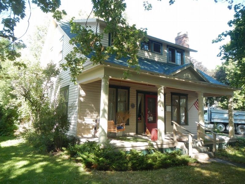
The Colonial Revival style is nicely represented in this early-twentieth-century residence built by Civil War veteran Joseph Stuart. One of Flathead County’s early pioneers, Stuart and his wife Nancy settled in the Flathead Valley in 1886. Stuart . . . — — Map (db m160856) HM
Dr. Victor Sundelius was the first owner of this charming cottage, built circa 1937. Victor and his brother Fred, both osteopathic physicians, practiced together in Kalispell during the 1930s and 1940s. The brothers were generous to the community, . . . — — Map (db m161105) HM
Belsami Tetrault was born in Montreal, Canada, in 1852 and came with her family by covered wagon to the Flathead Valley in the mid-1880s. Her husband Joseph, also a native of Montreal, left his family in 1881 to work on the railroad in the United . . . — — Map (db m161033) HM
In 1905, James E. Waggener purchased the business of retiring undertaker Nelson Willoughby. At this time nationally, the mortuary business was in transition. Funerals in the previous century had traditionally been held in the home, and the . . . — — Map (db m160722) HM
In 1905, James E. Waggener purchased the business of retiring undertaker Nelson Willoughby. At this time nationally, the mortuary business was in transition. Funerals in the previous century had traditionally been held in the home, and the . . . — — Map (db m160489) HM
The Kalispell Bee in 1903 described the newly completed residence of county clerk and recorder James Wiltse Walker as “one of the handsomest dwelling houses in the city.” A classic example of the Queen Anne style, typical architectural elements . . . — — Map (db m160968) HM
Described by the Flathead Herald-Journal as “an elegant mansion” in the “colonial style,” this residence’s overall symmetry and small gabled front dormers are typically Colonial Revival. However, the two-story turret, elaborate stained glass . . . — — Map (db m160336) HM
Carpenter William Williscroft owned, and possibly built, this one-story hipped-roof cottage between 1891 and 1897. He likely intended it as an investment property because by 1900 renters occupied the house. Sometime after 1950, owners replaced the . . . — — Map (db m160273) HM
Small farms and orchards dotted the fourteen blocks of this residential neighborhood when the original townsite of Kalispell was platted in 1891. Soon a few wood frame buildings were constructed on its lots for temporary housing and to provide . . . — — Map (db m160967) HM
Wide bracketed eaves, a gabled front porch, square columns, and a flared chimney identify this home as a premier example of the Craftsman style. Kalispell contractor Caesar Haverlandt built the home in 1912 for longtime school superintendent . . . — — Map (db m160270) HM
The Flathead Monitor declared in 1899 that the west side was way ahead of the east side with “a new residence being started there about every day.” By 1900, streets and sidewalks had replaced the open prairie. This Queen Anne style home . . . — — Map (db m161035) HM
Hudson Bay Company (HBC) agent Joseph Howse built a trading post just north of here in 1810, the first European settlement in the valley north of Flathead Lake. Described as “adventurous, tough, and intelligent,” Howse joined the . . . — — Map (db m127682) HM
In 1901, Great Northern Railway tycoon James J. Hill and local businessman John O'Brien joined forces to build and operate a 11-mile railroad line to a saw-mill on the north shore of Flathead Lake. Hill built this spur line in record time and . . . — — Map (db m127683) HM
A river of ice over 2,000 feet thick moved down this valley. Lake McDonald is evidence of its passing.
When the glacier receded more than ten thousand years ago, it revealed a changed landscape. The ice had quarried away huge amounts of rock. A . . . — — Map (db m82767)
Great Northern Railway chairman of the board Louis Hill dubbed the rugged mountains of Glacier National Park “America’s Alps.” Between 1909 and 1913, the Great Northern Railway constructed the Belton Chalet complex under Hill’s direction. It was the . . . — — Map (db m255175) HM
To visit Glacier National Park before 1930, you would have arrived on the Great Northern Railway, Buckboards waited at the Belton Depot to carry tourists over a nearly impassable road through swampy redcedar forest to the foot of Lake McDonald. At . . . — — Map (db m255173) HM
In 1895 there were no roads along Lake McDonald. Tourists arrived at this dock by wood-fired steamboat after getting off the train at Belton Depot and bumping along in a wagon to Apgar Landing.
The steamboat F.I. Whitney was the first . . . — — Map (db m45061) HM
A Glacier Tradition
National parks often seem timeless and are valued for the continuity of experience they offer to generations of visitors. At Glacier National Park, the past and future come together through a fleet of historic buses, . . . — — Map (db m45060) HM
Like many buildings in the park, Lake McDonald Lodge has a rustic architectural style. The lodge was built during the winter of 1913-14 with locally available materials, creating a rustic exterior of native stone and western cedar that blends . . . — — Map (db m45062) HM
For most of the 20th century, this corner was the site of the Cadillac Hotel. The Cadillac was not the first hotel in town; that distinction went to the Dodge Hotel, on Central Avenue between First and Second Streets. But with its proximity to . . . — — Map (db m160029) HM
This is the site of one of the oldest buildings in Whitefish. It opened as the Spraque Saloon in 1905, and. under a succession of ownerships, the building has catered to thirsty local residents for over 110 years.
In 1911, it was known as the . . . — — Map (db m160027) HM
This staid old brick building has a rich and colorful history.
The Duncan Samson Block, built in 1910 at a cost of about $32,000, was the third or fourth brick building in the fledgling town of Whitefish. Mrs. Jemima Duncan, a widow who had . . . — — Map (db m160000) HM
Not long after the Great Northern Railway announced its plans for a division point in Whitefish, Presbyterian missionary E. M. Ellis and Kalispell minister Alexander Pringle traveled by bicycle and rowboat to visit the site. Soon after, Reverend . . . — — Map (db m159943) HM
When the two-story 1st National Bank of Whitefish building was erected in 1910, the Whitefish Pilot declared in the headline: "Stability of Town Firmly Established."
The bank had been organized in 1907 with capital stock of $25,000. Its . . . — — Map (db m160001) HM
Whitefish served as a division point for the Great Northern Railway from its founding in 1904 until 1955. In 1925, one railroader called it “the most distinctively railroad town on the whole Great Northern system.” The second floor of . . . — — Map (db m159944) HM
This architecturally unremarkable building has a colorful history, having gone from an early-20th-century blacksmith shop to an early-21st-century liquor store, with several other incarnations along the way.
Built of locally manufactured . . . — — Map (db m160006) HM
The corner drugstore: an American icon.
Haines Drug opened on this corner in the heart of downtown Whitefish in 1926, having earlier shared the brick building (or "block", as such structures were then called) directly across the street on . . . — — Map (db m159999) HM
This Whitefish landmark has a long and colorful history, centering around the Japanese immigrant, M.M. Hori, who had come to the Flathead Valley as a house-boy for the family of Charles Conrad, a major figure in the founding of Kalispell. Conrad . . . — — Map (db m159946) HM
History was made on the night of June, 13, 1916 when the Orpheum Theatre opened on this site. This building was purchased by Lloyd J. Sissel and converted into what the press called "one of the classiest playhouses in the Northwest". He remodeled . . . — — Map (db m160007) HM
Historical records on this building are incomplete, but (it) is believed that it has alway housed an alcohol-related business. From 1915 to 1919, it was the home of the Kalispell Malting and Brewing Co. For most of its existence since then, it has . . . — — Map (db m160023) HM
This venerable building has a long and colorful history as a Whitefish watering place and entertainment center. Called the Dodge House when it was built in 1903, it eventually became known as the Pastime bar, a name it retained for many years, . . . — — Map (db m159947) HM
This building, built in 1921 by J.A. Robinson, has housed a variety of businesses in the ensuing decades. When construction was announced, the Whitefish Pilot called the lot in the heart of the emerging downtown complex "the most valuable piece . . . — — Map (db m160020) HM
The Bruck, a custom-designed bus-truck, has a unique place in the history of Whitefish and of the Great Northern Railway, an important residence in the life of the town.
Because the Empire Builder and Westerns Star passenger trains . . . — — Map (db m159945) HM
Built by the Great Northern Railway in 1927, the Whitefish Depot is not only a local landmark but is recognized fondly by hundred of thousands of people who have passed through Whitefish by train over the years. The building’s chalet-style . . . — — Map (db m49491) HM
… there should be erected at once at every camp, good, substantial, permanent buildings of one, two, three and four rooms for just the 'forgotten man'… There should also be constructed at every camp a building for a restaurant or cafeteria where . . . — — Map (db m167201) HM
The monument on the hill above was erected by the Great Northern Railway in 1925 to commemorate the farthest point north reached by the Lewis and Clark Expedition, 1804-1806. Captain Meriwether Lewis, with three of his best men, left the main party . . . — — Map (db m161235) HM
Relentless glaciers sculpted Mt. Reynold's jagged summit. When several glaciers erode a mountaintop from different sides, a steep mountain peak or horn develops. The result is a glacial horn like the Swiss Matterhorn.
There are glacial horns in . . . — — Map (db m45059) HM
He laid the foundation of the National Park Service, defining and establishing the policies under which its areas shall be developed and conserved unimpaired for future generations. There will never come an end to the good that he has done. — — Map (db m127494) HM
The Blackfoot Nation consist of three tribes, the Pikunis or Piegans, the bloods and the Blackfoot. Each tribe is divided into clans marking blood relationship. The majority of the Indians on this reservation are Piegans.
Many years ago the . . . — — Map (db m130198) HM
The Blackfeet Nation consists of three tribes, the Pikunis or Piegans, the Bloods and the Blackfoot. Each tribe is divided into clans marking blood relationships. The majority of Indians on the Blackfeet Indian Reservation are Piegans.
Many . . . — — Map (db m253968) HM
Every glacier in the park is receding. The park had over 100 glaciers when it was established in 1910. By 1966, 35 named glaciers remained. In 2015, only 26 met the size criteria to be designated active glaciers.
Snow avalanches, ice flow . . . — — Map (db m269934) HM
The Early Days
Even before World War I, the expansive flat area that is now Cut Bank International Airport drew the attention of local "brave souls" who dared to fly early aircraft and land on a grass airstrip. When WWI ended in 1918, the . . . — — Map (db m220324) HM
From a grass airstrip for barnstormers to Army Air Force Satellite Base for bombers to modern-day International Airport - the Cut Bank Airport Authority, the City of Cut Bank, and Glacier County are all extremely proud of the history and . . . — — Map (db m220325) HM
The present-day general store is the latest incarnation of a historic lodge, built in 1913 before there were roads into the park's interior.
To promote Glacier to adventurous tourists in the early 1900s, the Great Northern Railway built a . . . — — Map (db m128468) HM
Women, and especially club women, played outsized roles in creating and maintaining the community institutions - churches, schools, and libraries - that they and their families valued. Providing an outlet for women to exercise their leadership . . . — — Map (db m161119) HM
Lewis and Clark
National Forest
Memorial to
Theodore Roosevelt
This memorial was authorized by a Bill introduced in the Congress of the United States of America, by Representative Scot Leavitt, February 1, 1930 and approved by . . . — — Map (db m161505) HM
One of the most impressive geologic features in Montana is the mountainside north of you. Notice the prominent layer of white limestone half way up the mountainside. The rocks above this layer were deposited more than 50 miles southwest of here and . . . — — Map (db m161417) HM
A Glacier Tradition
National parks often seem timeless and are valued for the continuity of experience they offer to generations of visitors. At Glacier National Park, the past and future come together through a fleet of historic buses, . . . — — Map (db m45054) HM
Arriving at East Glacier depot, tourist in the 1920s could gaze at the glaciated peaks looming beyond their first night's lodging. The hotel appeared to be their last taste of civilization before riding horseback into the primitive backcountry of . . . — — Map (db m45055) HM
The second Indian Agency on the Blackfeet Reservation was built at Old Agency in 1879. Agent John Young moved the buildings from Upper Badger Creek with help from the Blackfeet Indians. Both men and women dug cellars, hauled stone and mixed mortar. . . . — — Map (db m130200) HM
In 1879, the Blackfeet agency was moved to this site from a previous site south of here to encourage the Blackfeet to take up farming. Old Agency was also the site of where over 600 Blackfeet starved to death, which is known as "The Starvation . . . — — Map (db m130211) HM
Chief Mountain, NINA-STA-QUAY, has alway been known to the Blackfeet people. Identified on maps as King Mountain as early as 1796, this outstanding landmark has long been revered for its supernatural powers. Generations of Blackfeet have used Chief . . . — — Map (db m220323) HM
With the disappearance of the buffalo in 1883, the entire tribe depended on the Agency for food. The agency failed to provide adequate rations during that winter, which resulted in over 600 tribal members starving to death. They were buried along . . . — — Map (db m130213) HM
With the buffalo gone the Indian was completely dependent on the Indian Agency. Food rations of meat and a variety of foods and materials were issued once a week per family. — — Map (db m130212) HM
In the 1920s, large parties of tourist gathered on horseback at Many Glacier Hotel. The hotel was part of a network of chalets built a day's ride apart-a way for guest to cross the park's wild, roadless interior while spending nights in relative . . . — — Map (db m45057) HM
Only about 26 glaciers remain from the 150 that were here in 1850. That number is dropping steadily. If the weather is clear, you might be able to see what is left of five glaciers in the Many Glacier Valley. As climate changes, both the visible and . . . — — Map (db m45058) HM
For thousands of years, western Montana, including the Jocko Valley, has been home to the Qluspé (Kalispel or Pend d'Oreille) and Séliš (Salish or "Flathead") people. In their tradition creation stories, tribal elders tell how . . . — — Map (db m159542) HM
The 1887 Dawes Act gave Congress the power to survey Indian reservations, assign land (allotments) to individual Indians, and open the remaining land to homesteaders. Although tribal leaders, including Chief Charlo and Sam Resurrection, resisted . . . — — Map (db m219655) HM
Congress opened the Flathead Reservation for homesteading in 1910, setting aside several tracts of land for townsite purposes. The town of D’Aste was platted soon after. Thomas P. Quinn operated a store and post office at D’Aste, serving fifty-three . . . — — Map (db m219139) HM
The National Bison Range was established in 1908 to help save the American Bison from extinction. Today populations are secure and bison roam in Parks, Refuges and on private ranches throughout the country.
The Bison Range is a National Wildlife . . . — — Map (db m96503) HM
For ten days in July 1855, near the confluence of the Bitterroot and Clark Fork Rivers, Salish, Pend d’Oreille, and Kootenai people met in council with US officials. The tribes struggled to understand the negotiations due to inept translators. In . . . — — Map (db m269898) HM
In the 1855 Treaty of Hellgate, leaders of the Salish ("Flathead"), Pend d'Oreille, and Kootenai tribes ceded to the United States most of their lands west of the Continental Divide. The tribes, however "reserved" certain areas, including this . . . — — Map (db m219146) HM
Homebuilding across the country stopped completely during World War II as materials were diverted to the war effort. When residential construction resumed after the war, architects broke with past traditions and embraced modernism. One-story ranch . . . — — Map (db m219135) HM
The first circuit-riding Methodist ministers, “the Lord’s Horsemen,” arrived in Montana in the 1870s to establish congregations among the territory’s early population. Settlers came to the Flathead when reservation lands opened to homesteading in . . . — — Map (db m219136) HM
The mountains rising to the east lie in the Mission Mountain Wilderness and the Mission Mountain Tribal Wilderness. The range is more than a natural wonder, it is the first place in America where an Indian nation has designated tribal lands as a . . . — — Map (db m159547) HM
Construction of the last Hudson Bay Trading Post, within the present borders of the United States, was started here in 1846, and was completed in 1847 by Angus McDonald. Angus originally named the fort "Connen" after a river valley in his Scottish . . . — — Map (db m159546) HM
This church, dedicated to St. Ignatius of Loyola, founder of the society of Jesus, was built in 1891. In 1840, Fr. Peter DeSmet came to Montana in response to the request of four separate delegations of Indians, and in 1841, he established St. . . . — — Map (db m219042) HM
About 15,000 years ago, this area was covered by huge glaciers which formed unique geological formations throughout the valley called drumlins or hills composed of glacial till deposited beneath the glaciers.
Ice periodically dammed up the . . . — — Map (db m113518) HM
Look and listen for the array of waterfowl who call Kootenai River their home and highway. Mallard ducks, Canadian geese, and common mergansers are year long residents, nesting along the water’s edge. Watch for waterfowl close to the rivers edge . . . — — Map (db m100112) HM
The land around Kootenai Falls has been explored and used for thousands of years by the Kootenai or Tunaxa People. The Kootenai tribe made up of seven bands, two in U.S. and five in Canada.
European traders and surveyors were lured to the region . . . — — Map (db m127287) HM
The river is named for the Kootenai tribe that lived and hunted in this part of Montana and adjoining territory in Idaho and Canada. They were settled south of Flathead Lake in 1855 with the Salish on the Flathead Reservation.
They were . . . — — Map (db m71509) HM
The Mullan Road is carved into the face of the mountains high above the Clark Fork River west of here. Lieutenant John Mullan tried to keep his wagon road as close to the river as possible. But when his work crews ran up against a mountain spur that . . . — — Map (db m123060) HM
"Great Spirit: teach us to walk soft upon the mother earth with all the creatures we live with ... Mitakuye oyasin! We are all related!" "Eagle Man" Ed McGaa, Oglala Lakota Sioux
The Bald Eagle is the magnificent emblem of the United . . . — — Map (db m123061) HM
During the last ice age about 15,000 years ago, an enormous glacier pushed down from British Columbia and blocked the Clark Fork River in northern Idaho. The glacier functioned as an ice dam creating the largest glacial lake known to have existed, . . . — — Map (db m123059) HM
The 1930s was a time of huge improvements to Montana's highways and bridges. The federal government provided funds to the state to alleviate massive unemployment during the Great Depression and, in the process, modernized the state's . . . — — Map (db m307137) HM
This structure is an example of how engineers incorporated a natural feature into the design of a bridge. Designed by Montana Highway Department bridge engineers, the bridge is a standard riveted Warren through truss. The bridge is unusual in that . . . — — Map (db m123057) HM
“With the cinders and ashes falling all around him, and so dark that he could not see his horse’s head at three o’clock in the afternoon, [Barringer] rode up to the face of the fire…[and] collected his scattered crews….” - . . . — — Map (db m45505) HM
“Fires of yesterday and last night have swept practically all the country from Avery to St. Regis. Nothing could have lived in the mountains last evening except for the tunnels.” - E. J. Pearson, Chief Engineer, Puget Sound . . . — — Map (db m45511) HM
“All that remained was to salvage what material that could be salvaged from the disaster, and reorganize for a new start.” - Clarence B. Swim, Assistant Forester
As the railroad operated rescue trains, Missoula residents . . . — — Map (db m45509) HM
“The whole twenty-five miles of railroad…between Avery and the Taft Tunnel was swept by a consuming blast of fire, so hot that pick handles lying in the open beside the track were utterly consumed.” - Elers Koch, Forest . . . — — Map (db m45510) HM
Just getting groceries up here could be a challenge
Deep winter snow sometimes made getting to school, going to the doctor, or buying food an adventure.
Families living at the top of the Bitterroot Mountains, here at East Portal and . . . — — Map (db m45544) HM
“I won’t die here in this creek… [I’m] getting out of here.” - Pinkie Adair, homesteader and camp cook
During the 1910 Fires, perseverance often meant the difference between life and death. At 26 years old, Ione . . . — — Map (db m45503) HM
The Milwaukee Road faced the daunting task of drilling a tunnel 23 feet high, 16 feet wide and 1.7 miles long into Idaho.
It was a damp, dark, dirty dig. After the approaches were prepared in 1906, and a faltering start in 1907, work . . . — — Map (db m45550) HM
Once a critical part of the longest electrified railroad in the world, the broken concrete foundation to your left is all that remains of the two-story, brick East Portal Substation.
Essentially a gigantic electric vault, East Portal was . . . — — Map (db m45542) HM
The Last Transcontinental Railroad
The Chicago, Milwaukee and St. Paul Railway’s Pacific Extension survived for 71 colorful years. Racing silk trains sped along the route, and long, rumbling troop trains carried men and materiel through . . . — — Map (db m45548) HM
…and Historians Trace the History along the Trail.
When the Milwaukee Road abandoned its route over the Bitterroot Mountains, salvage companies stripped the line of all the rails, ties, signals, posts and everything else of value. The . . . — — Map (db m45549) HM
Buried beneath busy Interstate 90 in the valley below are the bones of what the Chicago Tribune in 1909 named “the wickedest city in America”.
This “den of iniquity” sprouted up when the Chicago, Milwaukee and St. Paul Railroad began . . . — — Map (db m45552) HM
“The fire by this time was an awe-inspiring spectacle, the whole horizon to the west was aflame and the noise caused by the falling timber was terrific.” - Roy A. Phillips, Lolo Forest Guard
One of the most devastating . . . — — Map (db m45508) HM
Creation of the National Forest Service in 1905 brought Elers Koch, one of the nation's first professional foresters, to inspect and evaluate the Forest Reserves of Montana and Wyoming. Appointed Forest Supervisor of the Bitterroot and Lolo National . . . — — Map (db m123027) HM
Imagine a world very different than we know today. About 1.5 billion years ago during the Precambrian Era, the earth's environment was desolate, with no trees, fish, animals or birds. Shallow seas with extensive near-shore flats were fed by streams . . . — — Map (db m123024) HM
"Our work ... from the 16th of August to the 4th of December, 1859 consisted of cutting through this densely timbered section of one hundred miles, building small bridge were required, and grading thousands of places.... the work was heavy, and . . . — — Map (db m123025) HM
Wherever you are in Montana, you stand in the pathway of Lewis and Clark. Their 1804-1806 expedition was a grand adventure to investigate the people and resources of the newly acquired Louisiana Purchase and to seek a navigable passage across the . . . — — Map (db m123023) HM
The Mullan Road is carved into the face of the mountains high above the Clark Fork River west of here. Lieutenant John Mullan tried to keep his wagon road as close to the river as possible. But when his work crews ran up against a mountain spur that . . . — — Map (db m123054) HM
This marker commemorates the placement of the first 25 Bibles in November 1908 by the Gideons in the Superior Hotel, Superior (formerly Iron Mountain), Montana then located on this spot.
From that small beginning, The Gideons International . . . — — Map (db m123030) HM
Travelers along the Mullan Road and prosectors lured by the 1869 discovery of gold on Cedar Creek opened the way for settlement of this area. After the placer gold played out and other mining camps became ghost towns, the town of Superior continued . . . — — Map (db m123029) HM
Who was Frank Hamilton? No one really knows. Simple grave markers pay a humble tribute to the five miners buried at the Sand Park Cemetery between 1898 and 1914. Little more is known than their names and year of death. Most of the other . . . — — Map (db m71503) HM
For millennia, the Blackfoot River corridor has been part of the homeland of the Salish and Pend d'Oreille people. They and visiting members of other tribes used a vast network of trails to criss-cross this region of great abundance -- rich in game, . . . — — Map (db m123101) HM
By 1900 the Big Blackfoot Milling Company had largely depleted its nearby timber supplies and moved further up the Blackfoot. The mill, now owned by the Anaconda Company, got most of its timber from logs cut and dumped into the river and floated . . . — — Map (db m123103) HM
426 entries matched your criteria. Entries 101 through 200 are listed above. ⊲ Previous 100 — Next 100 ⊳