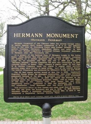
Hermann (Arminius) of the Cherusci tribe led several German tribes in battle against their Roman conquerors in 9 A.D., and defeated them in the hills of Teutoburg Forest near present Detmold. To later unified Germany, Hermann . . . — — Map (db m65467) HM
Stan Wilfahrt – an outstanding player for New Ulm's 1941 State Legion Champs & 1943 Brewers State Amateur Champions. He coached baseball at Cathedral High School for 1957-1978 with a 246-68 (.783) record. His teams appeared in nine state . . . — — Map (db m79894) HM
On this date at Chaska, Minnesota, New Ulm High School coach James Senske recored his 510th coaching victory, a new Minnesota State High School League baseball record for wins by a coach. At the completion of the 1994 season, . . . — — Map (db m79913) HM
Jacob Nix from Bingen Am Rhein in Germany was a key figure in the defense of New Ulm in 1862. Born in 1822, Nix early joined the push for a united Germany under a republican form of government. During the ill-fated 1848 Revolution, Nix served as . . . — — Map (db m65455) HM
This home was built by John Lind in 1887 and was a significant cultural, social and political center built on a prominence above early New Ulm. Swedish born Lind came to America and Minnesota in 1867 at age thirteen. While very young he was a . . . — — Map (db m65399) HM
The quality of life in New Ulm improved notably after a young teacher-coach accepted a position at New Ulm High School in 1928. During the succeeding 51 years, "Joe" Harman provided the inspiration that left this community a better place in which to . . . — — Map (db m66381) HM
In the early 1870's, fourteen settlers purchased this beautiful spot located on the north bank of the Big Cottonwood River and named it Jägers Ruhe (Hunters' Rest). The objectives of this group of hunters was to preserve this property for their . . . — — Map (db m66087) HM
The Kiesling House is one of the three downtown buildings in New Ulm to survive the Dakota War of 1862. Frederick W. Kiesling, blacksmith and ferrier, had built the modest frame house ($125) the year before the outbreak of the war. In August of . . . — — Map (db m65497) HM
During the Minnesota Sioux Uprising of 1862, eighteen men left New Ulm early on the morning of August 19, and travelled westward about 20 miles along the Big Cottonwood River to the area of Leavenworth. Searching for relatives and friends, they . . . — — Map (db m65486) HM WM
In 1914, two four-inch naval cannon barrels, each with a pyramid of balls, were placed on the courthouse grounds as a tribute to all Brown County citizens who served their nation in time of conflict. The United States Government reclaimed them in . . . — — Map (db m66967) HM WM
In 1851, leaders of the Dakota Nation signed the Treaty of Traverse des Sioux with the United States Government. This treaty opened new lands in Minnesota Territory for settlement. Two years later, German immigrants in Chicago, led by Frederick . . . — — Map (db m65452) HM
Schonlau Park, named in honor of Theodore H. and Clara K. Schonlau, is the setting for the City of New Ulm’s unique Glockenspiel. Local contributors were joined by donors from three foreign countries, 31 States, and 51 other Minnesota cities, in . . . — — Map (db m65492) HM
Frederick Beinhorn and Wilhelm Pfaender, pioneer founders of the prairie colony of New Ulm, were cut of the same cloth. Both came to America from Germany after the 1848 Revolution in Central Europe failed to unite German peoples under a new frame . . . — — Map (db m65694) HM
In memory of our honored brave who fell in defence of The Union.
In memory of those who fell in defence of New Ulm 1862.
In memory of those massacred by the Indians in Brown Co. 1862.
Erected by the citizens of Brown Co. . . . — — Map (db m68705) WM
While crossing this ravine a
recruiting party of the Civil War
was ambushed by the Sioux
Indians on August 18th, 1862, at
the noon hour.
The following were killed or
mortally wounded:
John Schneider • Ernest Dietrich . . . — — Map (db m73704) HM WM
On this site in 1859 Frederick Roebbecke built a seventy foot high wooden windmill for grinding corn and grain. Situated on a prominent ridge, it commanded an excellent view of the scattered settlement. Barricaded with sacks of flour and grain, the . . . — — Map (db m65400) HM
In 1874, shortly after George Kuhlman arrived in New Ulm, he constructed a home on this site. The same year, he was appointed as Brown County’s Attorney to fill a one-year opening left by his predecessors death. In addition to his legal vocation, . . . — — Map (db m153851) HM
To pay homage to the sturdy pioneers who founded the territory of Minnesota a century ago. And to express veneration for the pioneers of Brown County and members of their families who lost their lives during the Sioux War of 1862 — 1863. . . . — — Map (db m73642) HM WM
This neighborhood dates back to the early days of New Ulm. Oral history suggests the borders shown above. The origin of the name “The Wallachei” is obscure. The most likely translation is “low land horse pasture.” Or, legend . . . — — Map (db m65396) HM
The Turner concept of developing a sound mind and body through discussion of common problems and physical exercise was conceived by Frederick Jahn of Berlin in 1811. It was an effort to strengthen German resolve against the French conqueror, . . . — — Map (db m65426) HM
Von hier 717 fuss in der Richtung des Pfeils wurde am 11ten November 1856 der New Ulmer Turnverein gegruendet.
(From here, 717 feet in the direction of the arrow on the 11th of November 1856 the New Ulm Turnverein . . . — — Map (db m66239) HM
The first news of the Sioux Uprising was brought to New Ulm at noon on August 18, 1862, by survivors of a Civil War recruiting party that had been ambushed in Milford Township. Barricades were hastily erected in a three-block area on Minnesota . . . — — Map (db m65402) HM
The federal government erected the post office building in 1910, designed by James Knox Taylor, the supervising architect of the United States Treasury. Although the city's postal service began in 1856, it had been located in rented space . . . — — Map (db m74074) HM
The first river steamboat, WEST NEWTON, passed by here in 1853 going upriver with troops to lay out the site of Fort Ridgely. Two days later TIGER and CLARION followed with men and supplies.
For the . . . — — Map (db m66383) HM
Henry A. Subilia, a native of Jean, Italy, constructed the Waraju distillery in 1861. The construction cost total of $8,000, plus $2,000 for furnishings. The building required approximately 200,000 bricks and measured 72 feet x 46 feet. It obtained . . . — — Map (db m153916) HM
In 1857, Rev. August Huelster held the first Evangelical church service at the home of Charles Lauer in Cottonwood Township. In 1865, two acres of land were purchased in Cottonwood Township by John Mohr, Philip Pfisterer & Carl Schreyer, . . . — — Map (db m78463) HM
Searles, a small community in Section 21 of Cottonwood Township, was platted on October 10, 1899, by Harry and Anna Jenkins. It was a railroad station point named by officials of the Minneapolis and St. Louis Railroad.
The original plat . . . — — Map (db m67914) HM
Sleepy Eyes, or Drooping Eyelids, was born about 1780 in a Sisseton Sioux Indian village at Swan Lake in Nicollet County. The Bureau of Indian Affairs commissioned him a chief in 1824. His fame was achieved not as a warrior or hunter but as a . . . — — Map (db m67658) HM
In the summer of 1851 the Dakota Indians, a group of Native Americans who lived in Southern Minnesota, sold their land, 35 million acres, to the United States for $3,000,000. The Dakota agreed to move to a reservation which included land ten miles . . . — — Map (db m67983) HM
The village of Golden Gate occupied this area for some years. The town took its name from the U.S. Post Office established in 1868 with Ebenezer Fuller in charge.
Construction of a water-powered grist mill on Spring Creek in 1869 by . . . — — Map (db m70993) HM
The mill, built in 1867 by John Heimerdinger, was down 1/4 mile from Golden Gate on the Ruhe-Heim Creek. It was powered by a pond kept full by many wells, dug by hand. Wheat was ground by stones into flour and feed. — — Map (db m71062) HM
In 1866 the budding village of Iberia had a log school house, four frame buildings and a cemetery. The settlement is the center of Stark Township, organized in 1866.
Iberia crossroads was named for a community in Ohio because many of the first . . . — — Map (db m73752) HM
In honor of the
Brave Service Men & Women
who have defended and
continue to defend the
United States of America.
Sons of John & Mary Broich
Chris USNR, Art USNR, Walter USAF, Joseph . . . — — Map (db m67856) WM
In the 1850s there was a land boom in southern Minnesota. Jonathan Brown, 37 years old, filed on land along the Cottonwood River in what is now Burnstown Township. (S 1/2 of SW 1/4, Sec. 15; N 1/2 of NW 1/4 of Sec. 22)
Jonathan picked a good . . . — — Map (db m67820) HM
John and Daniel Burns were pioneer settlers in this area of brown County. Burnstown Township was named in their honor.
Railroad construction advanced westward and the name of the station stop here in 1873 was "Burns." A small settlement . . . — — Map (db m67542) HM
Proudly, we salute our veterans and
pledge eternal gratitude for their sacrifices and
gallant preservation of freedom for all.
seals of the United States Army • Air Force • Navy • Marine Corps • Coast Guard
Dedicated July 4, 1994 . . . — — Map (db m71172) WM
Carver Historic District
has been placed on the
National Register
of Historic Places
by the United States
Department of the Interior
Church by-the River,
Presbyterian Church
1913 — — Map (db m79234) HM
Carver Historic District
has been placed on the
National Register
of Historic Places
by the United States
Department of the Interior
Funk Hardware Store
ca. 1880 — — Map (db m79278) HM
Carver Historic District
has been placed on the
National Register
of Historic Places
by the United States
Department of the Interior
Minnesota Valley Oil Co.
1925 — — Map (db m75255) HM
Carver Historic District
has been placed on the
National Register
of Historic Places
by the United States
Department of the Interior
Stephen Kult Clothing Store
1871 — — Map (db m79125) HM
Carver Historic District
has been placed on the
National Register
of Historic Places
by the United States
Department of the Interior
Trinity Lutheran Church
1914 — — Map (db m79158) HM
This property
has been placed on the
National Register
of Historic Places
by the United States
Department of the Interior
Brinkhaus Livery Stable
1890 — — Map (db m59555) HM
City Square Park
City Square in Chaska has always been a gathering place and the heart of this community. The land was set aside for public purpose in 1852 in the original plat. Early settlers in Chaska found six earthen mounds on this . . . — — Map (db m63707) HM
This silo marks the site of the Christian Bender farm, homesteaded in 1854. George Bender, grandson of Christian, sold the farm to Henry McKnight in 1963. This was the first farm to become part of Jonathan.
Dedicated . . . — — Map (db m60394) HM
By 1804 Jean B. Faribault was trading in furs for the Northwest Company near the "Little Rapids" of the Minnesota River, 5 miles south of this point, and in this vicinity. His fur post of 1824 on the site of Chaska became the nucleus for the first . . . — — Map (db m41051) HM
The first burial at this location was 1857.
There is no cemetery record of who or where people are buried in this location.
During the decade of 1960 vandals damaged monuments.
The damaged monuments were removed[.] In the process the . . . — — Map (db m311182) HM
Dedicated by the Luther League to the honor of the men from the East Union Evangelical Lutheran Church who took part in the World War 1914-1918.
George W. Lundquist •
Clarence A. Ekström •
Wilhard E. Olander •
Henry R. Nord •
J. Elmer A. . . . — — Map (db m94398) WM
James J. Hill
The Dakota Rail Regional Trail follows the route of a former railroad line that was once part of the Great Northern Railway. Built by James J. Hill in the late 1800s, this historic line played a part in connecting Minnesota to . . . — — Map (db m98390) HM
Otto Oschner Jr • Army • WWI / KIA
Donald J Greene • Army • Vietnam KIA
Bill G Insall • Army • Vietnam KIA
Edward Born • Army • World War I KIA
Jerry E Auxier • Army • Vietnam KIA
Karsten H Panning • Army • Civil War / KIA
Wilmer H . . . — — Map (db m311229) WM
"The production of a forage plant so hardy as Grimm Alfalfa is almost without parallel in plant history... It is impossible to compute in dollars and cents what it has meant to the nation."
Everett Edwards, 1938
U.S. Department . . . — — Map (db m212539) HM
The Big Woods
When the first Euro-American settlers came to this area in the 1850s, the land looked very different than it does today. At that time, the spot where you now stand would have been near the center of a two-million-acre hardwood . . . — — Map (db m212415) HM
The Brick Farmhouse
The brick farmhouse before you was built by the Grimm family sometime around 1875. It replaced a small log cabin where the family had lived since they first acquired the property in 1857. More than just a new home, this . . . — — Map (db m212381) HM
To the Memory
of the
Defenders of the
Union,
1861 to 1865.
Erected by the Citizens
of
Carver County in 1892.
F. Anthony, S.M. Alexander, Ch. All, A. Arneson, L. Anderson, C.F. Anderson, S. Anderson, A.G. Anderson, J. Anderson, . . . — — Map (db m71715) WM
There was a time, not long ago, that harvesting meant long hours of hard manual labor. The process of harvesting grain meant first cutting the grain with a cradle scythe. The stalks were then gathered by hand and tied into bundles. Groups of 15-20 . . . — — Map (db m163406) HM
World War II
Poland -
Battle of the Atlantic -
Pearl Harbor -
Bataan -
Corregidor -
Coral Sea -
Midway -
Guadalcanal -
North Africa -
Bismarck Sea -
Salerno -
Tarawa -
Kwajalein -
Normandy -
Southern France -
The . . . — — Map (db m72282) WM
Erected in Memory
of Those Who Served
During the World War
1914 —— 1918
Allmann Andrew •
Bade Ed. •
Bade Henry •
Beck Walter •
Beiersdorf O.H. •
Boettcher Otto •
Boehmke Herb •
Brandenburg Henry . . . — — Map (db m71520) WM
Watertown is one of the oldest settlements in Minnesota’s south central region. Chief Little Crow of the Dakota Nation and his tribe often camped by the Crow River. At first the Chief and the settlers trusted each . . . — — Map (db m213030) HM
Minnie Christina Peterson Upon her father's death in 1914, Minnie became the sole proprietor of the Watertown General Merchandise Store. It's been said that Minnie was "way ahead of her time for a business woman." She passed away in a tragic . . . — — Map (db m213045) HM
Kathryn M. Burns "There are no words that can ever begin to describe the depth and meaning of the years that Kitty helped serve multiple patients in the Watertown and Waconia area. Kitty was truly a gracious, caring, and loving unselfish . . . — — Map (db m213084) HM
Civil War 100 Watertown pioneers served in the Union Army during the Civil War. They served in infantry, artillery, and cavalry regiments. By 1865 there was not a man left in the area between the ages of 18 and 45; the town remained at a . . . — — Map (db m213070) HM
About 13,000 years ago, glacial melt water that collected in a basin named Glacial Lake Agassiz burst through a natural earthen dike creating a huge torrent of water that carved the Minnesota River Valley as we see it today. There are . . . — — Map (db m169925)
They counted not their lives dear unto themselves
Dedicated in reverent and enduring memory our honored heroes who so valiantly served in the cause of freedom
They are enshrined in our hearts forever — — Map (db m259739) WM
In the spring of 1869 a group of settlers from Fayette County, Iowa ventured north to explore and settle in new land that was opening up in the Minnesota Valley. This party was led by Peter F Jacobson, and became known as the Jacobson Colony. They . . . — — Map (db m259743) HM
Church History
1889 Maxwell Providence Mission Church was organized at District 25 schoolhouse, Maxwell Township
1890 First church was built across the road & 1/4 mile North from this site.
1904 Purchased Methodist . . . — — Map (db m259638) HM
On September 26, 1862, 91 whites and about 150 mixed-blood captives, some of whom had been prisoners of the Dakota Indians for more than a month, were returned to Colonel Henry H. Sibley's military camp, later joyfully known as Camp Release. In the . . . — — Map (db m69118) HM
On September 26, 1862, the 270 men, women and children taken captive by the Dakota during the war were released to military commander Henry H. Sibley at this site, known from that time on as Camp Release.
Years later at the . . . — — Map (db m71384) HM
Experience showed Dakota Chief Maza śa (Red Iron) that it did little good to stand in the way of the U.S. government. He had opposed the 1851 Treaty of Traverse des Sioux but, in the end, had little choice when he and other Dakota . . . — — Map (db m164642) HM
Just two days after the captives were turned over, the brief military trials of the Dakota who had taken part in the fighting began here at Camp Release on September 28, 1862. The trials moved to the Redwood (Lower Sioux) Agency on . . . — — Map (db m71437) HM
The Geldner Mill
This historic sawmill played an important role in the settlement, clearing, and development of the countryside in which it stands. The machinery was manufactured in the late 1860s by Halbert and Paige of Painesville, Ohio, . . . — — Map (db m207640) HM
The accomplishments of the Mayo family in the field of medicine have brought fame to both its members and to Minnesota, for it was Dr. William W. Mayo and his two sons, William J. and Charles H., who founded the Mayo Clinic in Rochester, . . . — — Map (db m65417) HM
Named for Pierre Charles Le Sueur, French explorer who passed the site in 1700. This town on the old Red River trail includes two towns, Le Sueur and Le Sueur City which were laid out in 1852-53 on Prairie Le Fleche about a mile apart. Consolidation . . . — — Map (db m65509) HM
Le Sueur Tigers No. 1, William Dellaughter, commander
I. Allen,
E. Bacon,
A. Bangs,
H. Bridenthall,
B. Birdsall,
J. Birdsall,
P. Burch,
N. Burgers,
L. Butman,
F. Butteauz,
S. Carpenter,
W. Case, J. Coggswell, G. Cook, B. Cosly, . . . — — Map (db m65705) HM WM
In 1903, fourteen of Le Sueur's leading businessmen met in the back of the Cosgrove Harness Shop to start a canning factory. They called it the Minnesota Valley Canning Company. Sixty-seven shares of stock at one hundred dollars per share were sold . . . — — Map (db m65416) HM
Geologically young when compared with ancient rivers such as the Nile or the Amazon, the Minnesota River is only about 12,000 years old. It occupies a channel that was cut by the Glacial River Warren, when it drained Glacial Lake Agassiz, the . . . — — Map (db m65411) HM
To the memory of Reverend Emil Polášekwho for thirty-two years, from 1905 to 1937, served God as a pastor of The Church of the Holy Redeemer, rejoicing with us in our joys, comforting us in our sorrows, exhorting us by word of mouth . . . — — Map (db m212945) HM
Built on a shelf of oneota dolomite limestone, Ottawa is home to six little known treasures from the past. Platted in 1853, the once thriving village has left behind a collection of limestone structures that have stood the test of time, all built . . . — — Map (db m212838) HM
Was organized in 1857 and the stone building was erected in 1859 by the Methodists of this community and has served for 90 years as a place of worship and education. This church building is one of the three oldest Methodist church buildings in . . . — — Map (db m212845) HM
On the Red River Oxcart Trail to Traverse des Sioux
1854–First white man to claim land–Bruce Pierce.
1855-56–Then; Christian, John & Andrew Anderson; Christian & Torger Peterson & the Jensens.
1862–The Applebaum home . . . — — Map (db m73506) HM
This Church Was Moved to
Farmamerica, Wasega, MN June 1987
Site of the Brighton United Methodist Church
Established in 1854 after the Rev. John Tidlund responded to the prayers of the early settlers. Services were held in homes and . . . — — Map (db m75307) HM
1855 - First settlers were Jacob Harmon, Mr. Haresine, John Sidel, Jacob Gfeller, & Ole Nelson - Most of the early settlers came from Germany.
1856 - Village of Red Stone, near the ferry, was surveyed but never developed.
1856 - Hilo post . . . — — Map (db m66070) HM
The Post's surgeon lived here. In addition to treating the sick and injured, the post surgeon was himself a commissioned officer, in charge of enforcing proper sanitary measures. The regular inspection of living quarters, the water supply, . . . — — Map (db m71677) HM
Most officers in the regular army during the 1850s were professional soldiers with combat experience. Most had fought in the Mexican-American War (1846-47), and three quarters were West Point graduates. To those who had seen action in Mexico, . . . — — Map (db m71768) HM
A Minority in Their Homeland
For generations, the land stretching out around you was the homeland of the Dakota Indians. Through treaties in 1851, the Dakota sold all of their land in southern Minnesota. The treaties disregarded Dakota . . . — — Map (db m71126) HM
President Franklin D. Roosevelt Creates the CCC
During the early 1930s close to 40% of America's youth (16 to 24 years old) were unemployed and not in school. Twenty-five percent of adult men were unemployed. Out of this great economic . . . — — Map (db m71893) HM
The Dakota plan of attack on August 22 was the same as on the 20th—a volley of three shots from the north, followed by a rush of warriors from the east, south, and west. The plan was disrupted again when a mail carrier was spotted on the New Ulm . . . — — Map (db m199447) HM
You are standing where cannon fire stopped the Dakota assault on August 20, 1862. According to Tasina Wakanhdi (Lightning Blanket), who was involved in both attacks on the Fort, the warriors who made the first attack on Fort Ridgely were men from . . . — — Map (db m71702) HM
437 entries matched your criteria. Entries 101 through 200 are listed above. ⊲ Previous 100 — Next 100 ⊳