1755 entries match your criteria. Entries 201 through 300 are listed.⊲ Previous 100 — Next 100 ⊳
E Clampus Vitus Historical Markers
The Ancient and Honorable Order of E Clampus Vitus (ECV) is a fraternal organization dedicated to the preservation of the heritage of the American West, especially the history of the Mother Lode and gold mining regions of the area. More than 1,400 markers point the way to the past.
By Andrew Ruppenstein, November 8, 2009
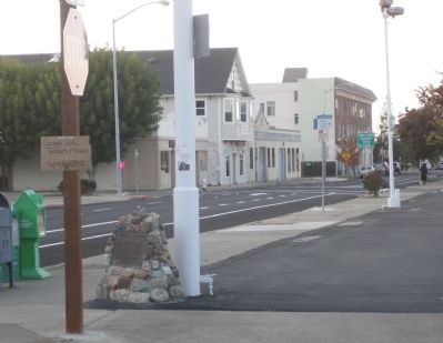
Birthplace of the Martini Marker. Looking along Alhambra Avenue
On this site in 1874, Julio Richelieu, bartender, served up the first martini when a miner came into his saloon with a fistful of nuggets and asked for something special. He was served a "Martinez Special." After three or four drinks, however, the . . . — — Map (db m57975) HM
This Victorian cottage was the home of the Robert Borland Family. Built in 1890 by Dr. John S. Moore, D.D.S., and originally used as his dental office. The property was inherited by his daughter, Mrs. Emma Moore Borland. The Martinez Historical . . . — — Map (db m16730) HM
This monument erected in honor of his contributions as a soldier, mountain man, and explorer who through his efforts and those of his breed such as Jim Bridger, Thomas Fitzpatrick, Jedediah Smith, helped explore and open the way to the West. There . . . — — Map (db m93508) HM
Dedicated to the family of Don Ignacio Martinez, who settled El Rancho Pinole in 1830. Many of his descendants rest here, members of one of Contra Costa's first families. — — Map (db m53061) HM
Potters field at Alhambra Cemetery. Here, marked by numbered headstones the size of bread loaves, are buried over 600 poor and unknown early pioneers of California and Martinez. The earliest known burial was in 1853 and they continued until the . . . — — Map (db m93541) HM
On this site in 1852, Hiram Fogg began a mercantile store.
Operating since as:
1854 - 1897 Simon Blum & Bro.
1897 - 1912 Baer Bros.
1912 - 1986 Hilson's — — Map (db m93573) HM
William Hook came to the California gold country in 1850 to sell mining equipment and build mining machinery. In 1853 Hook opened a general store at the corner of Ferry and Main Streets in Martinez. Over the years Hook brought up land in Contra . . . — — Map (db m93510) HM
In 1865, at the age of 17, James Rankin emigrated from a Scottish coal mining town after hearing of the "Black Gold" in Contra Costa. He worked with pick and shovel in the underground mines of Somersville.
In 1885, Rankin was elected . . . — — Map (db m93506) HM
The City of Martinez has been the home of a train station along the waterfront for 125 years. The first station (approximately 200 yards to the east of this site) was erected in 1876 and closed in 2001 when this station was opened.
More than . . . — — Map (db m93542) HM
Founded by Dr. Robert Semple in 1847, the Martinez-Benicia ferry was the first established and longest operating ferry service in the S.F. Bay Area. In 1850 Oliver Coffin took over the operation and with his brothers purchased a new ferryboat, the . . . — — Map (db m27645) HM
In this cemetery are laid to rest many of the early California pioneers, settlers and their families. One of the more famous is Joseph Reddeford Walker, XNGH - mountain man, guide and pathfinder. — — Map (db m93507) HM
In the city, from 1879 to 1932, the 70 acre parcel of land extending in a triangle from what is now Bush Street to Pacheco Boulevard to Brown Street to Alhambra Creek was owned by The Christian Brothers Religious Teaching Order, Founded by Saint . . . — — Map (db m112828) HM
In 1849, Vicente Martinez built a two-story adobe ranch house on his portion of the Rancho Pinole. This land was inherited from his father, Don Ignacio Martinez, a Spanish officer who became Comandante of the San Francisco Presidio and later Alcade . . . — — Map (db m50821) HM
The First National Bank Building was designed by E.L. Norberg and built by G.H. Fields & Co. in 1921.
In January 1927, the bank was purchased by Liberty Bank of San Francisco, which then merged with Bank of America Los Angeles later the same day. . . . — — Map (db m37488) HM
In 1860, at the confluence of the Sacramento and San Joaquin Rivers, settlers founded the village of Black Diamond. Named for the coal that was mined in the Mount Diablo foothills, the village of Black Diamond flourished as a shipping port for coal . . . — — Map (db m91846) HM
Built in 1923, this brick building was the home of the Coast Counties Gas and Electric Company which provided utilities to the City of Pittsburgh. The company closed its office in the 1950s and the building became a newspaper publishing and . . . — — Map (db m37423) HM
Patrick Rodgers left Ireland for America C. 1843 at the age of 10, without his family. In 1855, he arrived in California for the Gold Rush. In 1868, he and his wife, Mary Ann, bought this 149-acre site to grow wheat. The Rodgers, along with eight . . . — — Map (db m99625) HM
Port Costa's old timers are quite certain that the rumor of the Burlington Hotel being a bordello is untrue. Their reasoning is that the respected owners and their families lived nearby, therefore it could not have been a bordello.
However, the . . . — — Map (db m57971) HM
The SS Red Oak Victory is the last remaining ship of the 747 vessels built at the Kaiser Shipyards in Richmond, Ca, during World War II. Commissioned by the U.S. Navy as the USS Red Oak Victory (AK-235), on December 5, 1944, she served as an . . . — — Map (db m131188) HM
These young Welshmen died far from home in an 1876 mine accident. Despite hard times, these people of Nortonville pitched in to erect a white bronze monument on this site. This plaque keeps their memory alive. — — Map (db m199137) HM
Nearby are portions of the hull of the General Petroleum Corporation tanker S.S. Emidio, which on December 20, 1941 became the first casualty of the Imperial Japanese Navy's submarine force action on California's Pacific Coast. The ship was attacked . . . — — Map (db m143397) HM WM
The heroic voyage of this crossbreed steer; floating downriver from Klamath Glen and up the coast into Crescent City Harbor, was an inspiration to the flood victims of Klamath. He embodied their courage, stamina, and indomitable spirit. A living . . . — — Map (db m91941) HM
Following the California Gold Rush of ’49, swarms of Chinese miners came to make their mark on the diggings in the Mother Lode, including this Coloma Valley. They were industrious and self-contained and mostly content to thoroughly comb the old . . . — — Map (db m12225) HM
“Boys I believe I have found a gold mine” so said James W. Marshall to his millworkers on January 24, 1848, after he discovered gold in the tail race of Captain John A. Sutter’s sawmill at Coloma. This discovery started the great Gold Rush to . . . — — Map (db m12224) HM
The home of the pioneer Monroe family stood here for more than a century. The family matriarch, Nancy Gooch, came across the plains from Missouri as a slave in 1849. She gained her freedom in 1850 when California joined the Union as a . . . — — Map (db m17455) HM
This replica of Sutter’s Mill was based on research from many sources – a drawing by James Marshall, an old photograph of the mill, and the results of several excavations made on the original mill site. The building is 60 feet long, 20 feet wide, . . . — — Map (db m12206) HM
Trading post, emigrant stop, and mining camp of the 1850’s. This became one of the remount stations of the Central Overland Pony Express. Here at the Nevada House on April 13, 1860, pony rider William (Sam) Hamilton changed horses while carrying . . . — — Map (db m11571) HM
At this site on the old Clarksville-White Rock Emigrant Road was Mormon Tavern. Constructed in 1849, this popular stage stop was enlarged and operated by Franklin Winchell in 1851. It became a remount station of the Central Overland Pony Express and . . . — — Map (db m12056) HM
[Three small markers are mounted on the front of the building:]
Marker 1:
Balsar House
A hotel built in 1850 by
Madam Balsar
Remodeled for an opera house in 1870. Restored by the Independent Order Odd Fellows and used as a . . . — — Map (db m54812) HM
Founded August 7, 1849 by George Phipps and party. Nicknamed Growlersburg from the heavy nuggets that “growled” in the miners’ pans. Georgetown was the hub of an immensely rich gold area. After the disastrous fire of 1852 the old town . . . — — Map (db m57962) HM
Georgetown
Pride of the Sierras
Georgetown was founded in 1849 by George Phipps, a member of a party of sailors prospecting for gold, who first pitched his tent near the head of what is now known as Empire Canyon. George's town quickly . . . — — Map (db m54773) HM
A Military Company Was Organized
At Georgetown In August 1859, Called
The Georgetown Blues
This Is In Honor Of Them, And
Dedicated To All United States
Veterans Who Have So Honorably
Answered Their Nation’s Call To Duty
America . . . — — Map (db m55078) HM
This firehouse, completed in 1965, was built to replace one on the opposite side of Main Street which was inadequate to house modern equipment. Headquarters of the Georgetown Fire District, now in this building, were formerly on Church Street. — — Map (db m54929) HM
This was the site of a change station of the Pioneer Stage Company in the 1850’s and 1860’s. During 1860-1861, the Central Overland Pony Express maintained here the first pony remount station east of Sportsman’s Hall. — — Map (db m57977) HM
The youngest town acquisition of El Dorado County owes its origin to the Placerville and Sacramento Valley Railroad. They established a station for neighboring Amador County at this crossing of the roads. The town started on the completion of the . . . — — Map (db m19317) HM
This was the site of the most eastern remount station of the Central Overland Pony Express in California. Established as a trading post in 1851 by Martin Smith, it became a popular hostelry and stage-stop operated by Ephraim “Yank” Clement on the . . . — — Map (db m433) HM
Established on banks of “Hangtown” Creek as rich mining camp in spring of 1848. Millions in gold were taken from its ravines and hills. Supply center for surrounding mining camps and transportation terminus for famous Comstock Lode. John M. . . . — — Map (db m12732) HM
Gold Rush town and Western Terminus of the Placerville – Carson Road to the Comstock. Placerville was a relay station of the Central Overland Pony Express, April 4, 1860 – June 30, 1861. Here on April 4, 1860 the first east-bound pony . . . — — Map (db m57973) HM
Born Nebraska 1887. Educated Biltmore Forest School, North Carolina. Began career 1908 in California with U.S.F.S.
Major U.S. Army A.E.F. 1917 – 1919
General Manager
Michigan California Lumber Co. 1925 – 1949
California State . . . — — Map (db m57974) HM
“Somewhere here lie the remains of the three unfortunates hanged in late 1849 from the oak tree in the feed corral after fair trial by the vigilantes. This incident changed the name of Dry Diggins to Hangtown.
Let us not judge them too harshly . . . — — Map (db m227884) HM
This was the site of Sportsman’s Hall, also known as Twelve-Mile House. The hotel operated in the late 1850’s and 1860’s by John and James Blair, a stopping place for stages and teams of the comstock. It became a relay station of the Central . . . — — Map (db m609) HM
Gabriel Moraga of the Spanish Army, on Jan. 6, 1806 camped near here on the banks of a river never before seen by white men. The day was Epiphany, commemorating the visit of the three kings of the East to the Christ Child. This holy day suggested a . . . — — Map (db m27833) HM
One Quarter mile NW of here in a grove of oak tress on the south bank of Dog Creek was established "The Academy" in 1872. It was the first secondary school in Fresno County. J.D. Collins, later Sheriff was the first teacher. Just easterly of The . . . — — Map (db m28014) HM
Built in 1892 as one of the three depots along the line of the San Joaquin Valley Railroad, this structure was originally located on the Tarpey Ranch just southeast of what is now the intersection of Ashlan and Clovis Avenues. In the span of its . . . — — Map (db m101992) HM
In 1891, Marcus Pollasky formed a company to construct a railroad from the junction of the Southern Pacific Co. tracks in Fresno to the Sierra with the idea that eventually the railroad would cross the mountains and open the San Joaquin Valley to . . . — — Map (db m28017) HM
One of the largest stands of Giant Sequoias, it contained some of the finest Big Trees. The grove was logged as a private land between 1897 and 1907, first by the Sanger Lumber Company and later by Hume-Bennett Lumber Company, which in 1909 . . . — — Map (db m52239) HM
Arriving in Fresno County in 1870, Sands Baker purchased a quarter section of land at the base of what became Baker's Mountain. Baker continually added to this tract until he had about 2000 acres.
Baker was prominent in the mountain community. . . . — — Map (db m147608) HM
[Side A:]
Easton
In 1878, O.W. Easton and J.P. Whitney, San Francisco entrepreneurs, bought a total of 12 sections of land in this area (7680 acres), formed the Washington Irrigated Colony and began selling 20-acre farms. Allen T. . . . — — Map (db m229962) HM
Andrew Davidson Firebaugh was born in Virginia in 1823. He served with the Texas Mounted Riflemen in the Mexican War. Coming to California in 1849, he fought in the Mariposa Indian War under Major James D. Savage on the expedition that discovered . . . — — Map (db m229464) HM
In 1872, the old Central Pacific Railroad, forerunner of the Southern Pacific, constructed a north-south line through the San Joaquin Valley, which opened the valley to commerce and settlement. The railroad contructed a switch a short distance . . . — — Map (db m26132) HM
In 1874 600 people moved to what is now Fresno. Of those, 200 were Chinese, who made the brick and helped start the building of Fresno. A short time later, they were persuaded to settle west of the train tracks. They built an area of shops, which . . . — — Map (db m52981) HM
In June of 1919, William "Billy" Winning, age 14 died in a tragic accident at his family home on Van Ness Boulevard. In December of 1920, Billy's mother, Mae, decorated the deodur cedar in front of the home as a memorial to Billy, who had loved . . . — — Map (db m242281) HM
Approximately 2 miles north of this point, Fort Washintgon was built in the spring of 1850 by Wiley B Cassity (Cassady or Cassidy), Charls D. Gibbes, Major Lane and others. This fort, probably the first building erected in Fresno County, served as . . . — — Map (db m28013) HM
A temporary rough board building, containing county offices, was erected near the spot in the fall of 1874, about the time the cornerstone was laid for the original permanent courthouse. Fresno was selected by the voters in a previous spring . . . — — Map (db m27940) HM
During the year 1903, streetcars began to rattle along the city streets from the San Joaquin River through the fig garden area to downtown Fresno and east along Huntington Boulevard to Sunnyside.
Providing a reliable, entertaining, even . . . — — Map (db m27830) HM
On this spot in the early days was a flowing spring beside which stood a large green bush. Wild horses, deer, elk and antelope watered here and it served as a watering place for sheep and cattle.
The presence of this water caused the . . . — — Map (db m242667) HM
Fremont passed within sight of this spot on April 7, 1844. He was crossing from the San Joaquin River to the Kings River with his mountain men guides, Thomas "Broken Hand" Fitzpatrick, Kit Carson and Alex Godey. Fremont described a vast prairie with . . . — — Map (db m229460) HM
Kogetsu-Do
A Fresno landmark. Confectioner Kogetsu - Do has survived in the same location it has occupied for 99 Years. Sugimatsu Ikeda and his wife Sakino started the business in 1915 and were able to purchase this building on "F" Street in . . . — — Map (db m101863) HM
The Father of Fresno Irrigation. He was born in New York State in 1819, became a blacksmith and emigrated to California in 1852. He came to Fresno County in 1868 and employed by A. Y. Easterby, built the first irrigation system for lush fields of . . . — — Map (db m127909) HM
Established October 23, 1946 as America's first aviation community. Through the efforts of Wm. and Doris Smilie, 130 acres of rolling "hog-wallow" and hardpan were transformed into a public use airport, with a sod runway, connecting taxi-way and . . . — — Map (db m247120) HM
Built in 1883 by Moses J. Church, Fresno's first flour mill operated with Fancher Creek water run through Mill Ditch and down Fresno Street. The original wooden structure was replaced in 1892 by a brick building and was sold to the Sperry Flour . . . — — Map (db m69808) HM
[Marker mounted to the left of the entrance door.]
This building is the first Basque Hotel built near the Central Pacific Railroad lines that brought many new immigrants to Fresno and the San Joaquin Valley.
It was one of several . . . — — Map (db m101868) HM
Ernst Eilert, a European trained Brewmaster and his son William established the Fresno Brewing Company on this site in 1899. They built a six story brewery, a laboratory, a racking room, stable and other structures. Five kinds of beer were brewed . . . — — Map (db m26298) HM
In the 1860s a bandit held up the Hildreth to O'Neals
stage and stole $10,000 in gold bullion. He hid the loot in a tree stump and started a fire to hide his tracks. Later two locals discovered some of the gold and tried to sell it in Millerton. . . . — — Map (db m148147) HM
Due north of here, now covered by the waters of the lake, was the site of Millerton, first County Seat of Fresno County 1856-1874 — — Map (db m52442) HM
This site was originally called Mechanicsville, gradually changing to Humphrey Station after Miles Humphreys' store. Miles Humphreys came to California to join his brother John after the Civil War and saw an opportunity by opening his store at this . . . — — Map (db m28272) HM
Originally, in the late 1800's Kerman was called "Collis" in honor of the Southern Pacific Railroad President at the time, Collis P. Huntington. The Southern Pacific Railroad line was built through Kerman in 1891. The name was changed to Kerman in . . . — — Map (db m229450) HM
Steamboats carrying supplies for Millerton reached the head of navigation at Sycamore Point on the south bank of the San Joaquin River about one mile upstream from here. In the spring of 1852 and for many years thereafter paddle wheel steamers made . . . — — Map (db m229463) HM
Upon the arrival of the white man early in the nineteenth century, a group of people were already here. These people called themselves Choinumni. According to the Choinumni, they have been in this area for thousands of years. Prior to the arrival of . . . — — Map (db m27998) HM
James D. Savage was born in 1817 in Cayuga County, New York and moved to Illinois as a a child. He was described as a strong man with blue eyes and a magnificent physique. It was said that he was smart as a whip, shrewd in business and adept with . . . — — Map (db m101846) HM
Side A - North
Poole's Ferry
Most important of Kings River's earliest crossings, it was operated from 1851 - 1857 by William Campbell and John Poole 3 miles above this point. The ferry and its trading post served travelers and . . . — — Map (db m28844) HM
In the early 1850's, before it became a town, Reedley was in Mariposa County. The only way to cross the Kings River was doing so at your own risk or to find a ferry and pay a fee to cross. The Reedley area could claim two operating ferries. . . . — — Map (db m77752) HM
In 1891, a posse shootout forced the infamous Dalton Brothers gang from this mountain hideout. They made their way back to Kansas where they eventually met their fate in Coffeyville. The outlaws, long since gone, leave Dalton Mountain as their . . . — — Map (db m27962) HM
Its waters made possible the irrigation of a million fertile acres, despite a 39 year battle over water rights. From 1882 forward, 150 lawsuits were filed and early irrigators often used armed force to open headgates to water their crops. L. A. . . . — — Map (db m27996) HM
Founded by the Pacific Improvement Co. following the completion of Southern Pacific's east side railroad in May 1888. Its name honors Joseph Sanger, Jr., Indiana rail executive. Sanger, supported by a rich fruit citrus farming district which later . . . — — Map (db m28164) HM
"Yank" Hazelton, son of Joseph, a blacksmith, and Sophia Cleveland, was born in Coeyman, N.Y., in 1824. He emigrated to California through San Diego in 1853. He settled on this site and homesteaded this land in November, 1857, with his wife of 2 . . . — — Map (db m28069) HM
Born in Canada in 1836, orphaned at age 8, he worked at numerous jobs before arriving in California in 1858. In his 40 years here he pioneered in photography, discovered Tehipite Valley and other prominent Sierra features. He led construction of the . . . — — Map (db m28156) HM
[Marker Front:]
Groundwater Irrigation Beginnings
The San Joaquin Valley's groundwater reservoir was first tapped with a practical pumping plant 4 miles northeast of here on Dec. 12, 1894. William De La Grange of Selma, tired of . . . — — Map (db m28594) HM
On this 6 1/4 acre site, Libby, McNeill and Libby opened the San Joaquin Valley's largest cannery on July 18, 1911, less than four hectic months after the site was acquired and construction plans were announced. The initial construction cost was . . . — — Map (db m52240) HM
Founded along this street in the late spring and early summer of 1880 by Jacob E. Whitson, George B. Otis, Monroe Snyder and E. H. Tucker as a 40 acre townsite mapped from Whitson's homestead and wheat field. Selma boomed and first prospered here . . . — — Map (db m28161) HM
Two miles northwest of here astride Mill Flat Creek is the site of old Millwood. A sawmill town established in 1891. Railroads brought logs here for milling and later lumber from other nearby mills including that which cut the privately owned . . . — — Map (db m2979) HM
In the early 60's Elijah Sarvers, a solitary goatherd, was the first non-Indian here. In 1866 the Woods Bros. began making shakes on Pine Ridge, hiring Indians to carry them down the mountain. In 1867 the county granted them a franchise to build a . . . — — Map (db m28016) HM
Eureka was founded as a town in 1850 and incorporated as a city in 1874. Located on the remote northwestern coast of California, Eureka was the region's major port of entry by water in the 19th century before the construction of good access by land, . . . — — Map (db m113509) HM
By the early 1850's, newly arrived white settlers had moved into the Humboldt Bay area, causing conflict with the native inhabitants. To protect both Indians and settlers, Fort Humboldt was established in 1853 and operated until 1866. It became a . . . — — Map (db m19936) HM
"Big Diamond", a circus elephant, expired near here in 1927. His skinned hulk was buried. Years later, his bones were unearthed and speculation arose about a
Humboldt Mastodon until investigators were enlightened
by people who'd seen the . . . — — Map (db m22274) HM
Lit Dec. 1, 1868 to Mar. 3, 1951.
Built at 422 ft. elevation, the light swept 30 mi. to sea. The perilous waters here claimed nine ships. Mules took supplies to the site, 15 mi. north, the westernmost in the U.S.
Dedicated to the Keepers of . . . — — Map (db m51954) HM
Lit Dec. 1, 1868, the light from its first order Fresnel lens swept 30 miles to sea. Decommissioned in 1951, the structure slowly began to inch toward the 422’ cliff. The light was dismantled in 1998 and moved to Point Delgada, Shelter Cove by . . . — — Map (db m1093) HM
Founded April 8, 1850, Trinidad is the oldest town on the Northern California coast. During the 1850s, it served as a vital supply link between ships anchored at Trinidad Bay and miners in the Klamath, Trinity, Salmon River, and Gold Bluff mines. It . . . — — Map (db m1188) HM
Completed in 1919, the library was constructed with a $10,000 grant from industrialist and philanthropist Andrew Carnegie. Calexico's Woman's Improvement Club and the Farmers and Merchants Club encouraged the city to apply for the Carnegie funds. In . . . — — Map (db m62070) HM
Here on September 23, 1849, Lieut. Cave J. Couts, Escort Commander, International Boundary Commission, established Camp Salvation. From September till the first of December 1849, it served as a refugee center for distressed emigrants attempting to . . . — — Map (db m50586) HM
The Hotel De Anza was opened on May 28, 1931 by Will R. Conway, an experienced hotelman. The $48,000 cost was partly financed by Calexico citizens. It was opened with a big celebration after being built in only four month. The hotel featured three . . . — — Map (db m62071) HM
Camacho's Place was opened for business on December 12, 1946 by Richard Camacho and his wife, Juanita. It is erected on the site of a former Seventh-Day Adventist church and school that had been damaged and abandoned following a major earthquake on . . . — — Map (db m62073) HM
Known as Santa Rosa De Las Lajas (Flat Rocks), this site was used on March 8, 1774 by the Anza exploring expedition, opening the land route from Sonora, Mexico, to Alta California. On December 11 to 15, 1775 the three divisions of Anza's colonizing . . . — — Map (db m62074) HM
1755 entries matched your criteria. Entries 201 through 300 are listed above. ⊲ Previous 100 — Next 100 ⊳