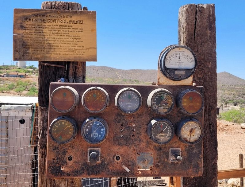
This control panel was used for the pressure lines.
The mined ore is usually crushed into small chunks and heaped on an impermeable plastic or clay lined leach pad where it can be irrigated with a leach solution to dissolve the valuable metals. The . . . — — Map (db m249731) HM
M. Calisher was a California company that opened a store in Tombstone in 1879. They sold general merchandise as well as lumber. Eighteen year old David Calisher managed the store. He was a member of a grand jury that indicted William Claiborne for a . . . — — Map (db m48528) HM
At 1:00 p.m. on April 21st, 1907, the "Million Dollar Stope" was created when the Good Enough Stope caved in dropping a horse and wagon 75' into a gaping hole. The driver had climbed down to see why his horse had stumbled only to find himself . . . — — Map (db m131088) HM
On December 28th of 1881 while crossing 5th St., Virgil Earp was ambushed and shot. Would be assassins hidden in a new building under construction opened fire with shotguns. Virgil was severely wounded. He survived, but lost the use of his left arm. . . . — — Map (db m48517) HM
In 1934, Robert Ripley
declares the Rose Bush
the World's Largest in the
Newspaper column
"Believe it or Not".
The fire of May 26th, 1882, destroyed the dwellings located here. In 1885, Mrs. Amelia Adamson built the Cochise House . . . — — Map (db m125645) HM
Sal Anderson and Jacob Smith opened Russ House in December of 1880 as a boarding house and hotel. It was adobe with a broad veranda in view of the mines. It featured spring mattresses and one of the largest dining rooms in Tombstone. Russ House is . . . — — Map (db m249779) HM
In 1881, Nellie Cashman aided in building an adobe structure which served as a combination church and rectory; the first Pastor was Father Emmanuel P. Schneider. Another church was built in 1882 and Bishop John B. Salpointe dedicated it in 1883. The . . . — — Map (db m27916) HM
Upon its completion on June 8, 1881 it became the largest, most elaborate theatre between El Paso, Texas and San Francisco, California.
Albert Schieffelin and William Harwood conceived and constructed a "first class opera house" for the citizens . . . — — Map (db m195859) HM
The railroad reached Tucson in March of 1880. Richard Grid had a railroad spike crafted of solid silver from the Toughnut Mine. It was presented to the President of the Southern Pacific Railroad as an inducement to bring a railroad spur to . . . — — Map (db m53401) HM
The First Protestant Church in Arizona Territory under the direction of Endicott Peabody who conducted the first services in this building on June 18, 1882.
The structure is of hand formed adobe brick, stuccoed in 1970 to protect the adobe. The . . . — — Map (db m27920) HM
The Bird Cage Theatre was built in 1881 by Billy and Lottie Hutchinson on the site of the killing of Marshal Fred White. After the fire of 1881, it became the only other theatre in Tombstone except Schieffelin Hall. It quickly became a first class . . . — — Map (db m249816) HM
In September of 1880 a new adobe structure, the Grand Hotel, opened for business. It boasted all the luxury and comfort that 1880 had to offer. It displayed Brussels carpets, a black walnut baluster, walnut furniture and rare oil paintings. John . . . — — Map (db m48515) HM
Tombstone was a mining town. Everything that happened here happened because of the lure of the silver and gold found by Ed Schieffelin in the hills of Tombstone in 1877. And so they came, the prospectors, laborers, miners, lawmen, “shady . . . — — Map (db m131095) HM
The Oriental Saloon was opened in 1880 by Milton Joyce with the gaming concessions run by Lou Rickenbaugh. The Epitaph News described it as "the most elegantly furnished saloon this side of the Golden Gate". Wyatt Earp bought a share of the gaming . . . — — Map (db m48524) HM
The picture of the "World's Largest Rose Bush", that has been given you, was taken during the blooming in the month of April. The rose is a white Lady Banksia and the root was sent from Scotland in 1885. The bush was planted to climb over the . . . — — Map (db m293656) HM
The four ore cars you see before you were left in place by miners when the Tombstone Consolidated Mines closed in 1904 these relics remained undiscovered for over a century until members of the Tombstone Mine Recovery and Preservation Team unearthed . . . — — Map (db m249718) HM
Architect Frank Walker designed this building in Victorian style adapted to Western Territorial. It is constructed of fired red brick. It has been in continuous service since 1882 for Mayors, Marshals and official city offices. In the 1880s it . . . — — Map (db m27918) HM
The devastating fires of 1881 and 1882 brought major changes to the Tombstone Fire Department. A new fire station was completed in 1881, a new Rescue Hook and Ladder Co. was formed, and a new water source was obtained. Thirty six miles of fifteen . . . — — Map (db m53403) HM
In 1877 prospector Ed Schieffelin searched for silver in Apache land. He was told he would only find his own tombstone. Schieffelin ignored the advice. The result was a strike worth at least forty million dollars.
This brought not only miners . . . — — Map (db m48507) HM
Buried here are the remains of Tom McLaury, Frank McLaury, Billy Clanton - killed in Earp Clanton battle Oct 26, 1881.
Dan Dowd, Red Sample, Bill DeLancy, Dan Kelly: Tex Howard hanged legally by Sheriff Ward for Bisbee massacre Mar 1884, John . . . — — Map (db m100173) HM
Wells Fargo had several locations in Tombstone. They were the major carrier of mail, bullion and payroll in the early years. While they hired agents and shotgun messengers, they contracted with local stage coach lines to carry express cargo. . . . — — Map (db m249815) HM
Lillian Erickson's husband, Ed Riggs,
was instrumental in the development
of Chiricahua National Monument.
, , , , , , , , , ,
He was quiet and warm-hearted – a man who liked to work with his hands. Ed Riggs grew up nearby . . . — — Map (db m151089) HM
They came when only the brave dared come: They stayed where only the valiant could stay. Born in Sweden. Americans by choice - not by accident of birth, they loved their adopted country and served her well.
Neil
Served five years in the . . . — — Map (db m28368) HM
Faraway Ranch represents a
transition from the wild, unsettled
frontier to a peaceful cattle and
guest ranch of the 20th century.
—————————
In 1887, shortly after the final . . . — — Map (db m28370) HM
It was at this location the Headquarters Saloon stood from the 1890's until it burned down in 1940. Warren Earp was shot and killed at the Saloon on July 6, 1900. — — Map (db m28179) HM
On 30 December, 1951, during a routine training flight from Merced, California, to Tyndall Air Force Base, Florida, Lt. Robert G. Westlund lost his life when his F-51 "Mustang" fighter plane crashed near Sunset Peak in the Galiuro Mountains . . . — — Map (db m28414) HM
The military campaigns against the
Apaches brought them together.
, , , , , , , , , ,
Young Neil Erickson came to America from Sweden. He joined the army and was promoted to 1st Sergeant in the 4th Cavalry at Fort Craig, New . . . — — Map (db m151094) HM
Earliest panel brick style commercial building in Willcox. Was a meat market during prohibition. Listed on the National Register of Historic Places. — — Map (db m28175) HM
Railroad Avenue became the Commercial center for the growth of Willcox and the Sulpher Springs Valley from the time of the construction of the Southern Pacific Railroad through the area in 1880. — — Map (db m28174) HM
[Marker mounted to the left of sculpture:]
Born December 31, 1920 to Horace and Faye Allen in Willcox, Rex Elvie Allen was cross-eyed at birth.
As a young boy, Rex sang in the barber shop on this very street. He and his Dad played . . . — — Map (db m28199) HM
This was the homeland of the Chiricahua Apache. From out of the north came these semi nomadic hunters. Separating from other Apache groups in the 1690’s, the Chiricahua Apache moved into southeastern Arizona. — — Map (db m100161) HM
"Sacred to the memory of these pioneers, they came when only the
brave dared come: they stayed
where only the valiant could stay."
Lillian Erickson Riggs
Swedish immigrants, Neil and Emma Erickson married in 1887 and . . . — — Map (db m28366) HM
Built by Delso Smith as an Army Officer reception center during the Indian wars. Bought by Mr. Schwertner in 1893 and donated to the local Historic Society in 1980.
It is listed on the National Register of Historic Places. — — Map (db m28418) HM
This is the only remaining original redwood frame Southern Pacific R.R. Station in Arizona. It is also the only known, original, on site, passenger depot still extant on the Southern – Trans – Continental Railroad route, between Los Angeles and . . . — — Map (db m28180) HM
Built by Thomas A. Huffman. The Toggery was originally constructed as a single unit and later Mr. Huffman built the adjacent building. Huffman's Toggery was established in 1916 as part of the Commercial Development of Willcox.
Listed on the . . . — — Map (db m28200) HM
Was constructed by P. Howard Pregenzer and crew
In Memory of
P. Howard Pregenzer
1894-1980
Resident of Willcox, Arizona 1927-1980
Construction began in 1934 and completed in 1936
Construction sponsored by the City of Willcox, . . . — — Map (db m28415) HM
Eight hundred years ago, a savannah-like grassland covered much of this high desert with abundant grasses. The residents would have collected and burned much of the nearby fuel, necessitating long walks to adjacent areas to gather wood. Sparse . . . — — Map (db m60105) HM
Named for one of Arizona's first U.S. Senators. A pioneer in development of trails and copper mines in Grand Canyon. Near here was the site of Tanner's Crossing of the Little Colorado River on the Mormon Trail from Utah via Lee Ferry to settlements . . . — — Map (db m80764) HM
Jesse Jefferson "Bear" Howard was one of the first settlers in Oak Creek in the 1880s, arriving there from California. Well known in the territory for hunting bears, Howard primarily sold the meat to merchants in Flagstaff and Williams. He hollowed . . . — — Map (db m263145) HM
Section crews were the laborers who built the railroads in the beginning and have continued throughout the years to maintain them. These crews were most efficient in moving heavy sections of rails when they all worked in unison. To accomplish . . . — — Map (db m178072) HM
On June 30, 1956, a TWA Constellation and a United Airlines DC-7 collided over the Grand Canyon. The 123 passengers and crew members aboard both aircraft perished.
This site is a common burial and memorial to 66 of the 70 TWA passengers and . . . — — Map (db m154949) HM
This 11-ton telescope, built by the Alvan Clark & Sons Telescope Manufacturing Company of Cambridgeport, Massachusetts, was installed at Lowell Observatory in 1909. It came with four secondary mirror combinations so that it could be operated at . . . — — Map (db m149451) HM
]Panel 1:]
Between 1100 and 1200, more people lived in this area than ever before, or since. Located along routes linking large populations to the northeast and south, villages here were well situated for trade. As people, goods, and ideas . . . — — Map (db m60079) HM
Box Canyon and Lomaki ruins are a short 15-minute walk from here, along the edges of ancient earthcracks. The 1/4-mile trail will take you back in time over 800 years to the remnants of this once-thriving community. You will see the few native . . . — — Map (db m60114) HM
A Village
You are entering the “Citadel,” a ruin from the late 1100s. Research has not been completed so it is important that we leave things as they are. Will there be extra storage spaces found, possible evidence for the . . . — — Map (db m60089) HM
Under the forebearer of this American Elm George Washington assumed command of the Continental Army at Cambridge, Massachusetts, on July 3, 1775.
This sprig of the "Washington Elm" was donated to the Arizona State Teachers College at . . . — — Map (db m263603) HM
The idea of a non-motorized trail
traversing Arizona from Mexico to Utah
was conceived by Dale Shewalter, a Flagstaff
public school teacher, after numerous
long-distance hikes throughout the state. In
1985 Dale walked from Nogales to . . . — — Map (db m121444) HM
Aubineau Building: The earliest buildings on this site were wood frame saloons, which burned in 1886 and 1888 and 1892. In 1892, ownership passed to Julius Aubineau, who later became Mayor of Flagstaff and is credited with installing the . . . — — Map (db m33267) HM
Because of its prime location, this corner, containing two lots, was one of the earliest in Flagstaff to be developed. Pioneer merchant J. R. Kilpatrick built New Town's sixth building here in December 1883. This wooden store building burned in the . . . — — Map (db m119945) HM
In 1888, David Babbitt, who had been running a lumber yard on this site, decided to construct a general store. Starting in late summer, he built a 35 X 70 foot structure on this corner, with the long side of the building running west along Aspen . . . — — Map (db m59504) HM
In 1857 Congress authorized Navy Lieutenant Edward F. Beale to survey a wagon road along the 35th parallel from Fort Defiance, New Mexico Territory, to the Colorado River. A secondary mission was to test the feasibility of using camels in the . . . — — Map (db m33348) HM
From 1857-60, Lt. Edward F. Beale and a crew of 100 men completed the first federal highway in the southwest from Fort Smith, Ark. to Los Angeles, Calif. at a cost of $200,000. The wagon road was used extensively by immigrants en route to . . . — — Map (db m33346) HM
The rich diversity of plants and animals of the Flagstaff area was first recognized in the summer of 1889 when Dr. C. Hart Merriam led a biological survey to the San Francisco Peaks. Merriam's "Life Zone Theory" detailed that temperature and . . . — — Map (db m201772) HM
The Box Canyon ruins are typical of many pueblos found in this region. Early inhabitants constructed walls of nearby sandstone and limestone, and used local soils to cement the stones together. The flat roofs were built of timbers laid side-by-side, . . . — — Map (db m60094) HM
The City of Flagstaff purchased this land in 1959 from the United States Forest Service.
In 1964, James Potter, Sr., long-time resident, entrepreneur and Flagstaff Chamber of Commerce President, led the effort to form a non-profit organization, . . . — — Map (db m33347) HM
Bushmaster Park is named in memory of Flagstaff's Company I-158th Infantry Regiment, Arizona National Guard, and their sacrifices for freedom made in New Guinea, the Phillipine Islands and Japan from 1941 to 1945.
"No greater fighting team ever . . . — — Map (db m60932) HM
In 1888, at the insistence of a group of Catholic
Laymen, The First Catholic Church in Flagstaff was built of brick on the south side of town. It was moved in 1911 to a temporary site just west of and across the street from the present permanent . . . — — Map (db m33336) HM
Understanding and predicting local weather patterns helps astronomers plan successful observing runs. Because of this, observatories such as Lowell typically maintain weather stations to monitor the conditions. One such station was set up at the . . . — — Map (db m149452) HM
The Hoxworth family was the first to develop this lot, when H. H. Hoxworth built a hardware and furniture store here in January 1884. The property was owned by his father, George Hoxworth, a wounded Union veteran of the Battle of Shiloh.
Like . . . — — Map (db m33268) HM
This area seems quiet and lonely today - but not 800 years ago. This valley was used for farming and hunting by the people living in Citadel, Nalakihu, and other nearby pueblos, all inhabited at about the same time. (You can see the ruins of at . . . — — Map (db m41716) HM
Plaza
An open area in the pueblo near the rim of the earthcrack is known as the plaza. In pueblos, the plaza was the center for many daily activities including grinding corn, making pottery, working obsidian into arrowheads, processing other . . . — — Map (db m60110) HM
This building for many years was the home of J. J. "Sandy" Donahue's famous Senate Saloon. After earlier frame buildings on the site had been destroyed by fire, Donahue built the present brick structure in 1888.
An important figure in . . . — — Map (db m33266) HM
The K.J. Nackard family came to Flagstaff in 1912 and opened a small general store at 106 E. Railroad Avenue. The store was successful. In 1921, Nackard built a home on this property, just a stone's throw from the store.
Soon afterwards, . . . — — Map (db m119932) HM
Volcanic activity to the south produced giant fissures or earthcracks throughout the Wupatki area in the Kaibab Limestone. This formation covers most of the western half of Wupatki National Monument. The Sinagua and Anasazi Indians who inhabited . . . — — Map (db m60098) HM
The Emerson School bell and concrete nameplate once graced Flagstaff's first permanent education institution, built by the city with a bond generated in an 1893 election. The following year, the Territorial Legislature encouraged school districts . . . — — Map (db m263147) HM
The City of Flagstaff City Council & Historic Sites Commission recognize this property for its Historic & Architectural Significance cited 1988 — — Map (db m157599) HM
Floods and People Chose the Rio's Course
For thousands of years, rain and snowmelt on the south-west slopes of the San Francisco Peaks flowed down the Rio de Flag drainage carving a shallow canyon where Bonito Street is located today. The . . . — — Map (db m263269) HM
Named for a pine tree stripped of its branches by a party of immigrants and used as a flagpole for a patriotic celebration on July 4, 1876. Nearby Antelope or Old Town Spring provided water and led to the establishment of a railroad construction . . . — — Map (db m33330) HM
Historians generally agree that Flagstaff derives its name from a flag-raising ceremony held July 4, 1876, by a group of settlers from New England who were camped within sight of this historic monument.
In February and May of 1876, two . . . — — Map (db m33365) HM
Flagstaff Presbyterian Church
1892 - 1916
Flagstaff Federated Community Church
1916-1927
Mexican Methodist Mission – El Divino Redentor
United Methodist Church 1927-present
The First Presbyterian congregation of Flagstaff was . . . — — Map (db m33364) HM
Flagstaff was a name on a map before the area had any significant population. The first permanent settler was Thomas F. McMillan who arrived sometime in 1876. On July 4, 1876, a party of emigrants traveling from Boston to California was camped at . . . — — Map (db m41717) HM
Original proprietors T.A. Riordan David Babbit Architect J. Kennedy Construction by Edivaros & Wiley Los Angeles National Registery of Historic Places Number FHR 107 — — Map (db m157598) HM
In northern Arizona, the history by the earth is revealed on a gigantic scale. Exposures of rock at the bottom of Grand Canyon reveal two episodes of mountain building, each separated by extensive erosion. These rocks, from two billion to 570 . . . — — Map (db m263751) HM
Another life-long employee of Lowell Observatory, Henry is best remembered for his Proper Motion Study of 1971, which entailed repeating the Pluto search plates after 25 years to determine whatever changes had taken place in the background of . . . — — Map (db m149456) HM
The United Nations' International Day of Peace is held annually on September 21 to encourage individuals, organizations, and governments to end conflict and promote peace within and among all peoples and nations. It is a global call for ceasefire . . . — — Map (db m263752) HM
Seen from here is the San Francisco Peaks Complex. Highest is Humphrey Peak, elevation 12,611'. The fourth highest is Aubineau Peak 11,800'. Nearby is Aubineau Springs, the original source for Flagstaff's first water system. Subsequent developments . . . — — Map (db m263142) HM
Logging wheels were originally an integral part of the early lumber industry in Northern Arizona. Originally designed in 1870 by Silas Overpack, a Manistee, Michigan wheelwright, the wheels were used by a local farmer to help him clear his land. . . . — — Map (db m33331) HM
Maker - Silas Overpack Wheelwright, Manslee, MI
c. 1900
Also known as Michigan High Wheels, Big Wheels, or Skid Wheels, these wheels were the workhouse of the forest. The large wheel here made it easy to transport logs over rough . . . — — Map (db m263150) HM
Lowell Observatory has been designated a Registered National Historic Landmark Under the provisions of the Historic Sites Act of August 21, 1935 this site possesses exceptional value in commemorating or illustrating the History of The . . . — — Map (db m149455) HM
Thomas F. McMillan (also spelled McMillon) was the father of Flagstaff. Born in Tennessee, he sought gold in California and raised sheep in Australia before moving to northern Arizona in 1876. Here he established a sheep ranch and farm just north . . . — — Map (db m33271) HM
Flagstaff's first congregation was formed by the Methodists in 1883 and they raised the first church five blocks east of here in 1887. In 1906 they moved here and constructed this Gothic style building of locally quarried red sandstone. The . . . — — Map (db m178071) HM
Beneath the inverted, forked ponderosa entryway awaits an adventure in pioneer history, country-western legends and ghost stories - one of northern Arizona's liveliest landmarks since 1931.
Recognized by Hampton Hotels Save-A-Landmark . . . — — Map (db m192855) HM
Nalakihu - A modern Hopi name, "House Outside the Village"
Farmers lived here about 800 years ago. (Roof beams gave tree ring dates in the late 1100s.) The way the walls join show this small pueblo was not built all at once, but was added onto. . . . — — Map (db m41713) HM
The facility was originally constructed in 1925-1926 by the Atchison, Topeka and Santa Fe Railroad as the passenger station for the Flagstaff stop. The City of Flagstaff acquired the building in 1992 using city of Flagstaff Bed, Board & Booze tax . . . — — Map (db m78739) HM
As the keystone shows, this building was constructed in 1911. Its owner was R.O. Raymond, M.D., one of Flagstaff’s first doctors. Raymond came west for his health. After a short stay in Williams, he moved to Flagstaff in 1906.
He was the . . . — — Map (db m59511) HM
The first building on this site was a wooden structure located at 22 N. San Francisco Street dating from the early 1890s. It was the home of a saloon with a cute name, The Office. (“Honey I can’t come home just yet, I’m still at The Office.”) . . . — — Map (db m59510) HM
This trail follows the south side of historic Route 66 from downtown Flagstaff to the east side of town. In the mid 1990s the City removed a series of Billboards from the strip or land between Route 66 and the BNSF railroad tracks, and replaced it . . . — — Map (db m263060) HM
For years, the only way to fight fire at the Observatory was with a soda acid fire extinguisher. This was a 30-gallon extinguisher on wheels that mixed water, soda and sulfuric acid (for pressure.) It was once used to save V.M. Slipher's house from . . . — — Map (db m263230) HM
The distant San Francisco Peaks would have looked much like they do today. To the east, however, Sunset Crater Volcano would still have been belching black smoke and cinders when the Sinagua and Anasazi lived here. The thick layer of cinders over . . . — — Map (db m60107) HM
This building was constructed in 1909 by John W. Weatherford, the man who earlier built the adjacent Weatherford Hotel. It was the headquarters for the Arizona Overland Telephone Company, housing its offices and physical plant.
Construction . . . — — Map (db m59966) HM
Ballcourts were common in southern Arizona from A.D. 750 to 1200, but relatively rare here in the northern part of the state. This suggests that the people of Wupatki intermingled with their southern Arizona neighbors - the Hohokam - who may have . . . — — Map (db m41696) HM
This blowhole - a crevice in the earth's crust that appears to breathe - is one of several found in the Wupatki area. It connects to an underground passage - size, depth, and complexity unknown - called an earthcrack. Earthcracks resulted from . . . — — Map (db m41701) HM
The Citadel
It was a remarkable achievement, to use primitive mortar and local stones to build the walls above you straight up from the edge of the top of the rock. “The Citadel” is the modern name given to this ruin because . . . — — Map (db m60087) HM
Historic Basque handball court (cancha) built in 1926 by Jesus Garcia, a Spaniard who migrated to Flagstaff in 1912. He owned and operated the adjacent Tourist Home. The Basque would reportedly herd sheep, drink, chase women, or play their beloved . . . — — Map (db m59498) HM
A gift to the Observatory from President A. Lawrence Lowell through this instrument the ninth planet Pluto was first found in 1930 ”It means a planet out there as yet unseen by Man, but certain sometime to be detected and added to the . . . — — Map (db m149454) HM
1851 entries matched your criteria. Entries 201 through 300 are listed above. ⊲ Previous 100 — Next 100 ⊳