The town of Aberfoil was incorporated January 26, 1839, in then Macon County, with the first election for councilors conducted and managed by Lewis Stoudenmire, Charles G. Lynch, Thomas Scott, David Hudson, and A. J. and E. A. Jackson. Aberfoil was . . . — — Map (db m61027) HM
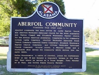
Side 1
In 1890, Reverend C. H. Thornton donated 10 acres of land where he
organized a church and the first public school for African Americans
in the Aberfoil community. The first school structure was a one
room log cabin. Rev. . . . — — Map (db m153582) HM
Samuel Sellers (1788-1857) of North Carolina arrived with his large family at Three Notch Road on January 29, 1835. Here, in what was then the Missouri Beat, Pike County, the first post office in the area was established, 2.5 miles west of . . . — — Map (db m61061) HM
Side 1
Built by U.S. Army engineers over the summer of 1824, Three Notch Road has served as Bullock County’s major transportation route throughout its history. It was constructed to facilitate military communication between Pensacola . . . — — Map (db m89638) HM
Lacking an established church nearby, pioneer families of the Fitzpatrick community into the mid-19th century took turns hosting worship services in their homes on Sunday mornings. "The Church of the Seven Sisters" was established in 1858 by seven . . . — — Map (db m67158) HM
Drill Ground of the Midway Guards 1860, later Company B 15th Alabama C.S.A. ordered to Richmond. Second Company 1861 assigned to Company C 45th Alabama C.S.A. ordered to Army of Tennessee. These and many later volunteers met the enemy in . . . — — Map (db m89636) HM
The Macedonia Baptist Church, located between the communities of Midway and Mt. Coney, was constructed by freedmen after the American Civil War, replacing the brush arbors used by the area’s antebellum slaves as sites for religious worship. Four . . . — — Map (db m60947) HM
Midway, a part of Barbour County in the mid-19th century, was also known as Five Points, a small community of a handful of dwellings, two stores, and a Methodist church of logs. In this Methodist church, Joel Willis, J.M. Thornton, Robert G. Hall, . . . — — Map (db m60908) HM
Margaret Elizabeth Merritt of Midway sold two acres for $5 to the state of Alabama in 1921 as a site for an elementary school for African-American children. Built in 1922 with matching Rosenwald funds, the Midway Colored Public School featured oak . . . — — Map (db m60910) HM
St. James Christian Methodist Episcopal Church founded by Reverend Jack McMillan, a former slave of Midway’s Daniel McMillan. Initially meeting outdoors under a brush arbor, ex-slaves and their children constructed a wood-frame church building soon . . . — — Map (db m60909) HM
Pioneer Samuel Feagin Sr. settled the Village of Midway in 1836. He came from Jones County, Georgia and established his residence at what is still called “The Old Feagin Place.” Samuel purchased a large acreage of land and sold it to . . . — — Map (db m61854) HM
This community, settled during the mid-1830s, was first called Fulford’s Cross Roads, then Missouri Cross Roads when a post office was established here in 1846. The name Perote, adopted in 1850 was suggested by veterans returning from the Mexican . . . — — Map (db m83256) HM
Side 1
Built by U.S. Army engineers over the summer of 1824, Three Notch Road has served as Bullock County’s major transportation route throughout its history. It was constructed to facilitate military communication between Pensacola . . . — — Map (db m89637) HM
The Bullock County Courthouse Historic District in Union Springs consists of 47 structures along three blocks of Prairie Street. Focal point of the district is the 1871 courthouse which is one of the finest post-bellum courthouses in the state and . . . — — Map (db m83257) HM
The Treaty of Fort Jackson of August 9, 1814, by Major General Andrew Jackson on behalf of the President of the United States of America and the Chiefs, Deputies and Warriors of the Creek Nation, established a boundary line between the Mississippi . . . — — Map (db m61026) HM
The Treaty of Fort Jackson of August 9, 1814, by Major General Andrew Jackson on behalf of the President of the United States of America and the Chiefs, Deputies and Warriors of the Creek Nation, established a boundary line between the Mississippi . . . — — Map (db m202468) HM
Log Cabin Museum
Early settlers of this area cleared land and built their first homes of logs in the early 1830s. This cabin was built by Reuben Rice Kirkland (1829-1915) about 1850. He and his first wife had ten children while living in the . . . — — Map (db m60969) HM
A 19th century cultural center located on the ridge dividing the coastal plain from the black belt originally Pike Co., Al.; Bullock Co. since 1866
Cemetery established in the 1830s for all faiths, situated between Mt. Hilliard Methodist . . . — — Map (db m181649) HM
Founded by settlers from Virginia, Georgia, and Carolinas. Building erected 1856. It was the central feature of the village of Mount Hilliard. Named in honor of Henry W. Hilliard -- who debated William L. Yancey in the 1850's. Revivals held at . . . — — Map (db m67553) HM
(side 1)
Settlers from the Edgefield District, South Carolina, organized the Sardis Baptist Church on June 10, 1837. The first building, a log cabin, was constructed in 1841 after John M. and his wife Amy Youngblood Dozier deeded four and . . . — — Map (db m67552) HM
Trinity Episcopal Church was established in Union Springs by Rev. DeBerniere Waddell in 1872 as a parish of the Episcopal Diocese of Alabama with seventeen communicants and an annual budget of $412.50. Until 1879 services were held monthly in the . . . — — Map (db m60973) HM
In the early 1800s, settlers coming from the Carolinas and Georgia received land grants and some purchased land from the Indians. They settled and cleared the forest for new farms and plantations in what would become a newly formed State of Alabama . . . — — Map (db m83258) HM
Early Native Americans in Butler County
Native Americans lived in the land that would become Alabama
for thousands of years before settlers arrived. They included
the Creeks, a multiethnic confederacy of tribes descended from
the . . . — — Map (db m246820) HM
(obverse)
The Butler Massacre
On March 20, 1818, Capt. William Butler, Capt. James Saffold, William Gardener, Daniel Shaw and John Hinson left Fort Bibb to meet Col. Sam Dale. They were attacked near Pine Barren Creek by Savannah . . . — — Map (db m83259) HM
In March 1863 Francis and Sarah Sheppard gave 3 acres of land to Methodist Episcopal Church South as a place for worship and burial. 2 more acres given by Alexander and Mary Sheppard Oct. 1868. Property sold to County Line Primitive Baptist Church . . . — — Map (db m70838) HM
City of Georgiana Founded in 1855
Early settlers moved from Virginia, the Carolinas, Kentucky, Tennessee and Georgia into the deep forests of southern Butler County. In 1855, the Rev. Pitt S. Milner established a home-stead and post . . . — — Map (db m86265) HM
Side 1
Hank Williams' Boyhood Home
Hiram Williams lived in Georgiana from age 7 to 11. In 1931, Mrs. Lillie Williams moved Hiram and his sister Irene from rural Wilcox County to this house owned by Thaddeus B. Rose. When he . . . — — Map (db m81276) HM
Front
William Bartram, America's first great naturalist, passed through northwest Butler County in July 1775. He described the "limestone rocks" and "banks of various kinds of sea shells" left by oceans that covered this area millions of . . . — — Map (db m120937) HM
Side 1
Created in 1819 by Act of Alabama Territorial Legislature from lands ceded by the Creek Indian Nation by the Treaty of Fort Jackson, 1814.
Named for Captain William Butler, soldier of Creek Indian War, 1813-14, early settler . . . — — Map (db m70755) HM
In
Memory of
Butler County
Veterans of
Vietnam War
Killed in Action
Likely, James T. • 10-2-1967
Taylor, Clarence • 5-28-1969
Rutherford, Michael T. • 11-5-1969
Cooper, William Morris • 9-7-1968
Johnson, Johnny L. • . . . — — Map (db m70771) WM
On August 28, 1917, Alabama National Guardsmen departed from Union Station in Montgomery for shipment to France as the 167th United States Infantry Regiment of the Rainbow Division. Men from Butler County killed in action during 1918 in that great . . . — — Map (db m120940) WM
Dr. John Coleman, born June 6, 1788 in North Carolina, was one of Butler County's earliest pioneer settlers. He built the Coleman-Crenshaw House some time between 1817 and 1821. In June 1820 the first election for Sheriff and Constable, held in . . . — — Map (db m130052) HM
Greenville City Hall-Site of Public School
A two-story brick Greenville Public School was built in 1897 on this site. In 1921, the upper story was partially destroyed by fire and the school was remodeled into a grammar school. In 1927, the . . . — — Map (db m70749) HM
A native of Virginia.
Pioneer settler of Butler County
for whom the county is named
Massacred by the Indians
near Butler Springs
March 18, 1818 — — Map (db m130049) HM
Ogly-Stroud Massacre
William Ogly built his cabin near this site at Poplar Springs along the Federal Road, and was killed here with most of his family on March 13, 1818. His friend Eli Stroud's wife was fatally wounded and their infant . . . — — Map (db m120933) HM
North side: Our Confederate Dead
West side: Erected 1903 by the The Father Ryan Chapter of the United Daughters of the Confederacy.
South side: To the memory of Butler CO's . . . — — Map (db m130089) WM
Greenville's oldest, established 1819. Captain William Butler, for whom the county was named, buried here. He was killed fighting Indians led by Savannah Jack in March, 1818. Greenville's oldest church, a community church established in 1822, . . . — — Map (db m70751) HM
The Butler County Electric Membership Corporation was formed as a rural electric cooperative in Greenville in July 1938. The first home receiving electricity from the cooperative was located near here.
The Cooperative's original Board of . . . — — Map (db m70756) HM
Commissioned and opened to the public in 1950, Sherling Lake is part of the Alabama Department of Conservation's efforts to construct public fishing lakes throughout Alabama in the 1940s. Greenville Chamber of Commerce President A.G. Johnson . . . — — Map (db m228690) HM
The Camellia City
Mr. J. Glenn Stanley, an ardent camellia enthusiast, dreamed of Greenville becoming “The Camellia City” and loyally promoted this slogan as editor of The Greenville Advocate. The city’s first Camellia Show was held at . . . — — Map (db m154579) HM
The Federal Road and the Palings
The Federal Road was built in 1806 as a shorter route from Washington to New Orleans and the new Louisiana Territory. The road entered Alabama at Fort Mitchell, Georgia and passed through Butler County near this . . . — — Map (db m130050) HM
Side 1
West Commerce Street Historic District
The completion of the railroad in the late 1850s brought this District into being. The District grew into a major trade center between Montgomery and Mobile. The capital accumulated . . . — — Map (db m70753) HM
Front
1941—1945
Dedicated
to the glory of God
and in grateful memory
of all those Butler Countians
who served their country
in the cause of freedom.
Rear
These made the
Supreme Sacrifice
1942 . . . — — Map (db m83260) WM
Oakey Streak
The community of Oakey Streak was so named for the abundance of oak trees in the immediate vicinity. From 1829-1843 the post office here was known as Middletown and from 1853-1935 Oakey Streak. Nearby was the Dawson Masonic . . . — — Map (db m70757) HM
Searcy School House was built in 1922, six miles north of Greenville,
Alabama. This historic building is one of the few original wood-frame
school houses remaining in Butler County. Considered state of the art
for its day, it was built by men of . . . — — Map (db m191642) HM
James Crook established this cemetery in
1837 on land he purchased from Creek
Indians. In 1834, he and his family moved
to this area from South Carolina.
In Nov. 1837, Samuel M. Crook, grandson
of James Crook, was the first person buried
here. . . . — — Map (db m36552) HM
At this site, on Nov. 3, 1813, after the Battle of
Tallasehatchee, known then as Talluschatches,
during the Creek Indian War,
Gen. Andrew Jackson found a dead
Creek Indian woman embracing her living
infant son. Gen. Jackson, upon hearing that . . . — — Map (db m36551) HM
Gen. John Coffee, commanding 900 Tennessee Volunteers, surrounded Indians nearby; killed some 200 warriors. This was first American victory. It avenged earlier massacre of 517 at Ft. Mims by Indians. — — Map (db m27610) HM
This stone marks the site of the Tallasahatchie Battle Field. On this spot Lieut. Gen. John Coffee with Gen. Andrew Jackson's men won a victory over the Creek Indians, Nov. 3, 1813. — — Map (db m36554) HM
On May 11, 2011, 40 students who were retracing the route of the original Freedom Ride, arrived in Anniston. The student Freedom Ride was part of a promotion organized by WGBH/Boston, a member of the Public Broadcasting system. The goal was to . . . — — Map (db m217423) HM
When seven injured "Freedom Riders" arrived at the Hospital on
this date, the mob that had attacked them earlier in the day
followed. The Riders were testing desegregation of public
transportation in the South by riding buses. The bus they . . . — — Map (db m106647) HM
Desegregation of the Library began when two African American
pastors, Reverends William B. McClain and Nimrod Q. Reynolds,
peacefully attempted to enter the building on September 15, 1963.
Their actions were endorsed by the city of Anniston . . . — — Map (db m106644) HM
South side
This tablet is
erected in honor
of the
Soldiers and
Sailors from
Calhoun County
Alabama
who served in the
Great World War
1917 - 1919
North side
Calhoun . . . — — Map (db m106706) WM
In the early 1940s, all of the buildings
on Block 148 were demolished to make
way for two new buildings, the USO
Recreation Center and a public health
building. Paul W. Hofferbert designed the
USO building for the Army. Hofferbert
was a local . . . — — Map (db m217677) HM
On May 14, 1961, a Greyhound bus left Atlanta, GA carrying among its passengers seven members of the Congress of Racial Equality (CORE), a.k.a. the “Freedom Riders,” on a journey to test interstate bus segregation. The bus was met by an angry mob . . . — — Map (db m35737) HM
Seaman Second Class, United States Navy, George Washington Ingram was killed in action in the defense of Pearl Harbor on December 7, 1941.
For Seaman Ingram's bravery, an American destroyer was built and named in his honor. The U.S.S. George . . . — — Map (db m106617) HM
Outstanding local industrialist as President, Kilby Steel Company; Chairman, Board of Directors, Alabama Pipe Company; President, City National and Anniston National Banks. Served as Mayor of Anniston (1905-09); State Senator (1911-15); Lieutenant . . . — — Map (db m35758) HM
Called “A poem in cedar & stone,” its history is intimately related to that of Anniston: Town Founders, Daniel Tyler & Samuel Noble, inspired its conception, funded its construction & caused Woodstock Iron Co. to donate the land on which . . . — — Map (db m35759) HM
Front
This was the site of the Greyhound bus terminal where on May 14, 1961, a bus carrying black and white Civil Rights Activists known as "Freedom Riders" was attacked by a mob of whites who were protesting desegregation of public . . . — — Map (db m106621) HM
This sign marks the start line of the
Woodstock 5K, one of the oldest continuous
footraces in the southeast. First held in
1980, the race takes place the first Saturday
in August each year and rollercoasters
through the historic neighborhoods . . . — — Map (db m217680) HM
The violence reached a crescendo when a flaming bundle of rags was thrown into one of the broken windows. Within seconds, the bundle exploded, sending dark gray smoke throughout the bus.
Three of the Riders found open windows, dropping to the . . . — — Map (db m217417) HM
Block 148, the block on which you are standing, was first developed in 1880 when three identical brick houses were constructed at the southeast corner of the block as rental properties for workers at the nearby factories. This 1888 Bird's Eye View . . . — — Map (db m217433) HM
Commanded Horse Artillery of
Army of Northern Virginia, C.S.A.
Killed at Kelly’s Ford, Va.
March 17, 1863
Styled “The Gallant Pelham”
By Robert E. Lee — — Map (db m36546) HM
On July 3, 1887, a congregation of 45 people met at the Opera House on Noble Street to organize a new church. Originally called Second Baptist Church, the name soon was changed to Twelfth Street Baptist Church.
In 1889, it became Parker . . . — — Map (db m36545) HM
Prelude: 12 p.m.- 12:54 p.m.
Just before this picture of the Greyhound Bus Depot at 1031 Gurnee (below left) was taken, approximately 75 men had gathered in front of it. They quickly dispersed as free-lance photographer for The Anniston Star, . . . — — Map (db m217412) HM
Pursuit: 1:25 p.m. - 1:35 p.m.
Heading to Birmingham, the battered bus turned south on Gurnee from the station and west on 10th St. while men rushed to their cars to follow. Police escorted the bus to the city limits where they turned back, . . . — — Map (db m217416) HM
Rescue
Once there, all of the injured were treated at the urging of an FBI agent on the scene. In the meantime, the crowd outside the hospital grew larger and more menacing, with some Klansmen threatening to burn the building to the ground. At . . . — — Map (db m217420) HM
4005 entries matched your criteria. Entries 301 through 400 are listed above. ⊲ Previous 100 — Next 100 ⊳