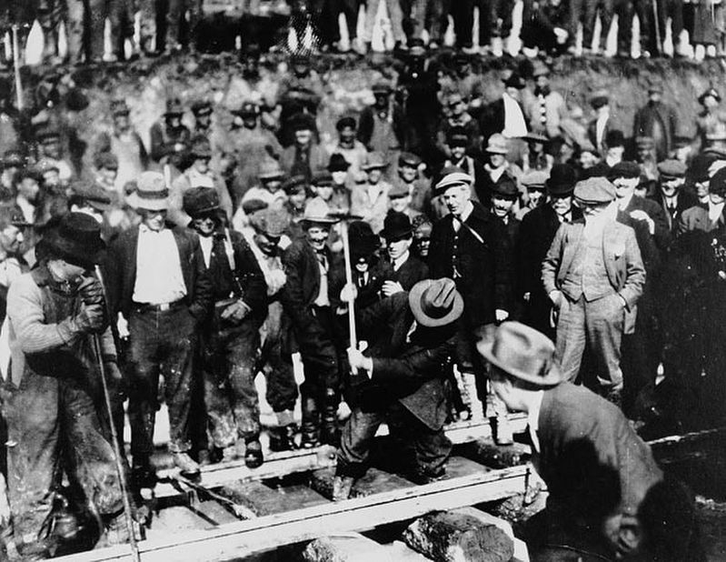
The last spike in Canada's second trans-continental railroad was driven near this site on April 7, 1914. The Grand Trunk Pacific became the most important factor in the dvelopment of Central British Columbia. However, financial problems plagued the . . . — — Map (db m187999) HM
In 1952, the Kenney Dam was constructed on the Nechako River to service the new Alcan aluminum smelter at Kitimat, resulting in the creation of the Nechako Reservoir and the relocation of over 75 families. The damming also linked the rivers and . . . — — Map (db m8855) HM
Perry Collins, an American, envisioned a land route to link America and Asia by telegraph. All attempts to lay a cable across the Atlantic had failed.
Western Union had completed 800 miles northerly from New Westminster in 1865-66, when the ocean . . . — — Map (db m187980) HM
Born of the Klondike Gold Rush of 1898, the 1,900 mile Dominion Telegraph Line linked Dawson City with Vancouver via the CPR wires through Ashcroft. Built in 1899-1901, the line blazed a route across this vast northern section of the Province but . . . — — Map (db m187925) HM
From 1889, sternwheelers and smaller craft fought their way through the Coast Mountains, churning past such awesome places as “The Devil's Elbow” and “The Hornet's Nest”. Men and supplies were freighted upstream, furs and gold downstream. A quarter . . . — — Map (db m187963) HM
First bridge built in 1856
Described as a graceful wooden spiderweb, the first Hagwilget Bridge was built by the indigenous population using only knives and axes. It was 150 feet long, and swayed 100 feet above the churning waters of the . . . — — Map (db m198556) HM
Head of sternwheeler navigation on the Skeena. The town grew at the landing close to the Indian village of Gitenmaks. Crews from the Collins Telegraph arrived in 1866. Following them Omineca gold miners, Hudson’s Bay pack strings and “gandy . . . — — Map (db m9073) HM
This site, once the largest village of the Bulkley Valley Indians, later was named after the pioneer missionary, Father Morice. Salmon, staple food of the Indian, concentrated in the canyon and were caught with basketry traps, dip-nets, and . . . — — Map (db m9072) HM
The Gitxsan are people of the Skeena River or River of Mist. For 10,000 years the Gitxsan have dwelled in their traditional territory and today approximately 13,000 members live in communities known as Gitwangak, Gitanyow, Gitsegukla, Hagwilget, . . . — — Map (db m187933) HM
In 1825 diplomats representing Russia and Great Britain met in St. Petersburg to resolve several navigational, commercial and territorial matters in dispute on the North West coast of North America and in particular, the immediate . . . — — Map (db m292190) HM
The developing provincial salmon industry spread northward when the Inverness Cannery opened here in 1876. The first cannery in northern British Columbia, it took advantage of the abundant sockeye runs up the Skeena River to challenge the dominance . . . — — Map (db m9075) HM
Salmon canning stimulated economic development on this coast. North Pacific is the oldest West Coast cannery still standing. From here the Bell-Irving family shipped high quality salmon directly to England before 1900. Typical of most canneries in . . . — — Map (db m9203) HM
Born 16 May, 1856 in Rock Island, Illinois, Charles Hays, the visionary promoter with a remarkable talent for raising vast sums of money, spear headed this great transcontinental railroad system and its west coast port, designed to rival . . . — — Map (db m309259) HM
The first municipal election for the new incorporated City of Prince Rupert was held on May 19th, 1910, just four years after the first Grand Trunk Pacific Railway survey parties landed on Kaien Island, or Lax Kxeen as it is known to the local . . . — — Map (db m309875) HM
This park, formerly known as
Acropolis Hill
was re-named on April 12, 1946
Franklin D. Roosevelt Park
in memory of a great leader and in tribute to the thousands of United States Armed Forces who served here in World War II and . . . — — Map (db m309294) HM
This area, a Railway right of way, was known originally as Cameron Cove & in 1908 renamed when a Swiss man John Nehring unloaded a herd of cows for his dairy from a barge.
On these waterfront flats the first hospital was built by Railway . . . — — Map (db m309829) HM
The odyssey of the "Khau Maru" has a mystic quality. On September 25th 1985, Kazukio Sakamoto left Owase, Japan for a day of fishing aboard his beloved "Kazu Maru". Unfortunately, he never returned.
A year and a half later the "Kazu Maru" . . . — — Map (db m309064) HM
The Kwinitsa Station, built in 1911, was originally located along the Grand Trunk Railroad Line between Prince Rupert and Terrace. When CN decommissioned the station in 1985, the Kwinitsa Station Relocation Committee, with help from the City of . . . — — Map (db m309608) HM
For the most conspicuous bravery and skillful leadership when in attack under incense artillery, rifle, and machine-gun fire, Colonel Peck was awarded the Victoria Cross.
In September 1918 at Villiers les Cagnicourt, France (The . . . — — Map (db m309801) HM WM
A pioneer of Prince Rupert, Bud was born and raised in the only house on the Court House grounds. He worked for 33 years as a dedicated public servant with the British Columbia Buildings Corporation as a groundskeeper and took exceptional care to . . . — — Map (db m309362) HM
Hans Siniarski and his wife Naida, the designers and sculptors, donated the statue to the City of Prince Rupert for the 75th anniversary celebrations in 1985. Hans constructed the statue using donations from local citizens and businesses. . . . — — Map (db m309721) HM
This mural was completed in the summer of 2019 by Coast Tsimshian artist Russell Mather with the assistance of students at Coast Tsimshian Academy, a private school based in Lax Kw'alaams, BC. Russell Mather is an established artist and carver . . . — — Map (db m309205) HM
This mural was completed in the summer of 2019 by Coast Tsimshian artist Russell Mather with the assistance of students at Coast Tsimshian Academy, a private school based in Lax Kw'alaams, BC. Russell Mather is an established artist and carver . . . — — Map (db m309220) HM
Built by the Grand Trunk Pacific Railway (now CN) for Assistant Harbour Engineer Joel H. Pillsbury and his family, "Number One Pacific Place" was one of the first settler residences in Prince Rupert.
The distinctive gables of Pillsbury house . . . — — Map (db m309489) HM
"Canada's friendliest little city!"
Global location 54°19′ N 130°21′ W
In 1902 Charles Melville Hays [missing text] promoting a second Trans-Canada Railway, "The Grand Trunk Pacific" (now CN). Kaien Island was chosen by . . . — — Map (db m309807) HM
(Southwest Face):
Our Glorious Dead
In memory of the men of Prince Rupert who died in action during World War I
1914 - 1918
"Their name liveth forever more"
A. Blyth •
A. Brighton •
A. Carss •
W. Crippen •
C. . . . — — Map (db m309445) WM
In memory of
C65050 Private Allan Milton Olsen,
"D" Company, the Midland Regiment, Royal Canadian Infantry Corps, Canadian Active Service Force, who lost his life, on 5 November 1942, during a patrol on the Kaien Island Highway, when his Bren . . . — — Map (db m309479) WM
Prevailing westerly gales and high flood tides in the spring and fall made construction of a lighthouse here one of the most hazardous tasks in Canadian maritime history. Nevertheless, contractor J. H. Hildritch of Prince Rupert . . . — — Map (db m309148) HM
The Skeena, “river of mists,” makes a major cleft through the Coast Mountains. To Coastal Tsimshian Indians and Interior tribes it was vital to trade and travel. In later years, Port Essington, near the river’s mouth, became the main port of this . . . — — Map (db m9074) HM
Constructed in just 8 months in 1942,
this 2,450 kilometre highway provided
an essential transportation link to the
northwest of North America during
the Second World War, and has since
remained a major transportation
artery. . . . — — Map (db m135256) HM
Seeking a route to the Pacific Ocean, this resolute fur trader and explorer, with his party of 9 men and a frail bark canoe, portaged nearby in May 1793 to avoid the awesome Peace River Canyon. On July 20 he reached tidewater. By this unrivalled . . . — — Map (db m188028) HM
Once called “The Beaver Plains”, this townsite was named in honour of Dr. G.M. Dawson, outstanding Canadian geologist and scientist, whose expeditions in B.C. covered almost every field of natural history. His geodetic surveys of 1879 reported the . . . — — Map (db m188018) HM
In 1793 Alexander Mackenzie and North West Company adventurers discovered this route through the Rocky Mountains. During 1805-08 Simon Fraser built forts and trading posts west of the mountains. Furs of the Pacific watershed began moving eastward. . . . — — Map (db m187958) HM
In the summer of 2000, two young boys tubing down Flatbed Creek stumbled upon ankylosaur tracks - the longest dinosaur trackway in British Columbia at the time. This discovery was a turning point in the development of Tumbler Ridge and the Peace . . . — — Map (db m187874) HM
In 1898, Fritz Miller and Kenny McLaren found gold on nearby Pine Creek, triggering British Columbia's last placer gold rush. The boom subsided by 1908, but gold has kept Atlin alive. Now Miller and McLaren lie here among hard bitten prospectors, . . . — — Map (db m188029) HM
Please remember that the landscape here is fragile and easily damaged. Please stay on packed trails to reduce damage to artifacts and vegetation. Building remains like the one shown here are important archaeological sites and are . . . — — Map (db m248978) HM
In the spring of 1898, a sea of tents stretched from here to Lake Lindeman. Travelers from the Chilkoot Trail and White Pass routes met at Bennett. They found barbers, jewelers, cobblers, hot baths, hotels, restaurants, saloons, a police post, a . . . — — Map (db m248966) HM
St. Andrew's Presbyterian Church served new settlers in Bennett from 1899-1902. Post-stampeders wanted to build boats, not churches, so the first minister held services in bunkhouses, tents, or hotels.
The completed church offered many . . . — — Map (db m248972) HM
Tagish and Tlingit families were here long before the gold rush, and are still here today. For them, this is home-not a place to hurry through on the way to somewhere else. Moose, goat, fish, wolverine, marten, beaver, rabbits, . . . — — Map (db m248964) HM
Here at Bennett you are in Chilkoot Trail National Historic Site, one of Canada's nearly 900 national historic sites. Each of these special places has its own story and is an important part of Canadian history and identity. Parks . . . — — Map (db m248890) HM
Over 20,000 stampeders hiked the Chilkoot and White Pass routes in 1897--98. Most spent 3 to 12 weeks getting their supplies across. The railway opened to Bennett a year later, and the town boomed until the rails reached Whitehorse. . . . — — Map (db m248891) HM
This area is covered with Tlingit and Tagish names. These names are tied to the land and stories; they help people navigate and make sense of the world. In Tagish, Bennett Lake is M`en Cho` (big lake). In Tlingit, it is Ch'aku`x Anax dul.adi Ye` . . . — — Map (db m248963) HM
They hold socials, write letters, have business meetings, meet engagements, read smoke, and file saws (when there are no ladies present). And sometimes do a little courting in the place, which is a better-equipped town, they would . . . — — Map (db m267942) HM
Klondike Gold Rush International Park
More than a century ago, gold was found in a tributary of the Klondike River, setting off a stampede to the area and forever changing the Yukon and Alaska. More than 100,000 people headed north . . . — — Map (db m248888) HM
The prospect of quick riches lured hundreds of placer miners to the Cassiar, where gold was discovered first at Dease Creek in 1872. Rich claims were later found at Thibert Creek and here at McDame Creek. From this creek in 1877 a 72-ounce solid . . . — — Map (db m187916) HM
The present-day location of Canadian Customs is also the site of one of the White Pass & Yukon Route railway stations. The station was named Fraser, probably to honor a politician from eastern Canada who had helped the railway company in its early . . . — — Map (db m248642) HM
This section of the Klondike Highway from the U.S. border to Log Cabin passes through terrain not usually accessible by road- a sparse and sometimes eerie subalpine landscape of lakes and stunted trees. This transition of vegetation between the . . . — — Map (db m248649) HM