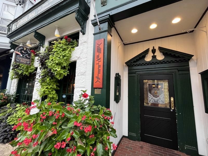
This is an example of "Ogham" writing. It is a style of Irish alphabet and writing dating from the 1st Century. It is read from the bottom to the top.
This sign says,
"Go Navy, Beat Army" — — Map (db m232497) HM
"St. Clair Wright said many times that Historic Annapolis accomplished more in the eight years I was mayor than in any other period. That makes me feel awfully good."
Roger "Pip" Moyer, 2002.
Historic preservation in Annapolis . . . — — Map (db m114540) HM
This is an example of "Ogham" writing. It is a style of Irish alphabet and writing dating from the 1st Century. It is read from the bottom to the top.
This sign says,
"Welcome to Galway Bay".
— — Map (db m114858) HM
130 Dock Street
could have been placed on
the National Register
of Historic Places
On October 29, 1776, George Washington brought his wife, Martha, to this very location hoping to treat her to ice cream. Sadly, it would not be until . . . — — Map (db m288626) HM
This commercial structure was one of several built between 1908-1913 after a fire destroyed the City Hotel. Merchant James F. Strange had the building constructed during his ownership. The building has remained in the Strange Family and in retail . . . — — Map (db m114549) HM
The property at 163 Main Street was originally part of a section of land confiscated from British Loyalists. The lot contained the City Hotel which was a well known hostelry. After a fire destroyed the City Hotel, the lot was subdivided and in 1903 . . . — — Map (db m6311) HM
This site owned by Amos Garrett was surveyed as Lot 46 on James Stoddert's 1718 plan of Annapolis. The Lloyd Dulany family lived here from 1761 until 1783. The group of buildings known successively as Mann's Tavern, City Tavern and the City Hotel . . . — — Map (db m6194) HM
38 Maryland Avenue has been a fixture of Annapolis since 1878. This property was once owned by Samuel Chase, who signed the Declaration of Independence. Once a private residence, the property has been thoughtfully reimagined as five distinctive . . . — — Map (db m295707) HM
In 1771 when Annapolis merchant Charles Wallace laid out plot lines on Cornhill Street, former ship captain Beriah Maybury leased two plots and built this house which he opened as the King's Arms Tavern in 1773. In 1792 he renamed it the Sign of the . . . — — Map (db m6450) HM
Built in the 1920s, this property was one of the last mixed-use buildings constructed on Maryland Avenue in the 20th century. The upper level is a luxurious apartment with beautiful views above the antique store below. Previously, the building . . . — — Map (db m295720) HM
Built between 1844 and 1854, 64 State Circle began as a physician's office and later served as a dental office for a former Annapolis mayor. After a fire in 1913, the structure was rebuilt using salvaged materials from the Maryland State House, . . . — — Map (db m295718) HM
Annapolitans and county residents visited this site for medical care for nearly a century after the founding of the Annapolis Emergency Hospital in 1902. The hospital first purchased the home of former mayor Edwin Seidewitz, part of which probably . . . — — Map (db m114790) HM
1984
Banneker-Douglass Museum
As the official museum of African-American history and culture for the State of Maryland, the Banneker-Douglass Museum is dedicated to discovering documenting, preserving and promoting . . . — — Map (db m114557) HM
Civil War Dead
An estimated 700,000 Union and Confederate soldiers died in the Civil War between April 1861 and April 1865. As the death toll rose, the U.S. government struggled with the urgent but unplanned need to bury fallen Union troops. . . . — — Map (db m114568) HM
The story of historic preservation in Annapolis is one of community involvement. Efforts to protect the historic element of Annapolis extend back to the nineteenth century. In . . . — — Map (db m114793) HM
"Annapolis is an almost perfect example of town/village GOLD Bay Partner." Comment from the presentation to Annapolis as a Gold Medal Community Partner.
Environmental Protection Agency, 2007
"And for the support of this Declaration, with a firm Reliance on the Protection of divine Providence, we mutually pledge to each other our Lives, our Fortunes, and our sacred Honor."
With these ringing words of resolve, . . . — — Map (db m114543) HM
2005
Wings and Sails
Annapolis has a stunning array of outdoor sculpture, paintings, murals, and other public artwork. Each of these paintings was commissioned by the Art in Public Places Commission.
"Wings and Sails" is . . . — — Map (db m114800) HM
General Butler to Governor Hicks
Off Annapolis, April 22, 1861
"Have I your excellency's permission...to land my men, to supply their wants, and to relieve them from the extreme and unhealthy confinement of a transport vessel not fit to . . . — — Map (db m114563) HM
Civil War Annapolis
In April 1861, Gen. Benjamin Butler and his Massachusetts troops entered the Maryland capital to ensure the state remained in the Union. The U.S. Army then reformed the Department of Annapolis, headed by Butler, to . . . — — Map (db m114566) HM
In the decades before the American Revolution, Annapolis was the customs port for the upper Bay western shore. Ships clearing in and out paid duties and fees to the local naval officer. With good shipyards (including Ship Carpenters Lot north of the . . . — — Map (db m19288) HM
This image of Anne Catharine Green pays homage to her as the first woman printer/publisher in the country. Appointed by the Maryland Assembly as the Official Printer of the Province, she printed all public documents and currency of the colony. . . . — — Map (db m114789) HM
Annapolis Charter 300, the city wide commemoration in 2008 of the 1708 city charter granted during Queen Anne's reign, was especially rich in inspiring original public art, music and choral work, a ballet suite, films, sculpture, photography, . . . — — Map (db m283181) HM
Site of the oldest and most prominent African American congregation in Annapolis, MD. In 1803, seven free African Americans bought the land and established the First African Methodist Episcopal Church. It was closed in 1832 in a local reaction to . . . — — Map (db m6191) HM
Major General · In the American Army during the Revolutionary War · Killed while valiantly leading Maryland and Delaware troops against superior numbers at the Battle of Camden in South Carolina, August 19, 1780. — — Map (db m295713) HM WM
Major General · In the American Army during the Revolutionary War · Killed while valiantly leading Maryland and Delaware troops against superior numbers at the Battle of Camden in South Carolina, August 19, 1780. — — Map (db m295715) HM WM
Baron Johann de Kalb was a distinguished German soldier who served as a major general in the Continental Army during the American Revolutionary War. He was a friend and mentor of the Marquis de Lafayette.
De Kalb served at Valley Forge . . . — — Map (db m75680) HM
Baron Johann de Kalb was a distinguished German soldier who served as a major general in the Continental Army during the American Revolutionary War.
commanding a division of Maryland and Delaware soldiers at the Battle of Camden, South . . . — — Map (db m295712) HM
This site was the first freestanding secondary school for all African American children in Anne Arundel County. Citizens groups, including the Stanton Parent-Teachers Association, led the charge for its construction. Bates opened its doors on . . . — — Map (db m157089) HM
Wiley H. Bates High School has a strength beyond bricks and mortar — its real foundation has always been its people. The last African American class to put on robes of purple and gold and receive their diplomas was the class of 1966, but . . . — — Map (db m157085) HM
On March 25, 1655, colonial Governor William Stone landed Maryland militia at the Puritan settlement of Providence, located at the mouth of the Severn River. He planned to subdue the settlers who had asserted their independence from the . . . — — Map (db m309692) HM
The firefighter and EMS provider are ascending the staircase of time as they depart from this world. they are running to their calling to do the job of serving our community with strength, determination and sacrifice as if going to war. The . . . — — Map (db m9286) HM
The maritime industry and the history of Annapolis are closely intertwined. This connection extends beyond downtown to historic Eastport, the neighborhood located across the Spa Creek Bridge. Eastport was developed after the Civil War as Horn Point . . . — — Map (db m114799) HM
Lieutenant John Rodgers (USNA Class of 1903) took off from this location in the Wright B-1 aircraft on September 7, 1911. With less than 450 feet to become airborne, an eager group of midshipmen assisted by running alongside while pulling ropes . . . — — Map (db m250537) HM
As a Redemptorist, Father Seelos was stationed in Baltimore, Pittsburg, Annapolis, Cumberland Detroit and New Orleans. He preached missions and retreats throughout the country.
Father Seelos served here as Pastor of St. Mary's Parish in 1857 . . . — — Map (db m200103) HM
Dedicated to the Brown and Leanos families that operated a grocery and restaurant business, respectively at this location since the late 1890's. — — Map (db m6387) HM
Near this spot
which was then the shore of the bay,
the Brig “Peggy Stewart” was burned
by her owner, “Anthony Stewart.”
October 19, 1774
To pacify the indignation of the
citizens roused by the payment of . . . — — Map (db m6313) HM
The 8th Massachusetts Infantry reached Annapolis April 21, 1861, on the Railroad Ferry Maryland. Col. Benjamin F. Butler forwarded his and the 7th New York Infantry Regiments to Washington. Shortly he was directed to prevent the legislature from . . . — — Map (db m6312) HM
100 Years
From the Depths - Sea Power
1900 - 2000
Dedicated to those
who serve beneath the seas,
families and support personnel
[Back of marker}:In recognition of the generosity
of the following donors
Lockheed Martin . . . — — Map (db m6398) HM
The porch you see before you is a modern reconstruction of this principal entrance to the Carroll House. It was added to the house in the 1770s by Charles Carroll of Carrolton and removed by 1866 when a two story passage was built between St. . . . — — Map (db m175948) HM
Patriot politician and future Declaration of Independence signer Samuel Chase began building this Georgian mansion in 1769, but he couldn't afford to finish the house and sold it two years later to Edward Lloyd IV. The wealthy Eastern Shore . . . — — Map (db m305390) HM
Given in recognition of all members of the Class of 1956 who served our nation so faithfully in Navy, Marine Corps, and Air Force careers; in industry, government, and the professions; and to our wives and families whose continuing support was so . . . — — Map (db m127932) WM
This montage is the collaborative effort of George "Lassie" Belt, children from the Stanton Community Center (listed below), and Artwalk curator, Sally Wern Comport. This artwork, part of the Annapolis 300 celebration, is at the entrance to the . . . — — Map (db m130944) HM
In the 1700s, the shore of Annapolis followed approximately along the line of buildings that now front Dock Street, Market Space, and part of Compromise Street—everything closer to the water is built upon fill. Through the next three centuries, . . . — — Map (db m114794) HM
Has been designated a Registered National Historic Landmark Under the provisions of the Historic Sites Act of August 21, 1935. This site possesses exceptional value in commemorating or illustrating the history of the United States U.S. . . . — — Map (db m6199) HM
In command of the Central America, home-bound with California Gold seekers, Captain Herndon lost his life in a gallant effort to save ship and lives during a cyclone off Hatteras, September 12, 1857
"Forgetful of self, in his death . . . — — Map (db m7213) HM
February 22, 1797: At the Presidential Mansion in Philadelphia, President George Washington formally presented Irish-born John Barry with Commission Number One in the newly formed United States Navy. With the commission, backdated to the . . . — — Map (db m114812) HM
Annapolis' Sister City of Wexford, Ireland, was the boyhood home of John Barry, naval hero of the American Revolution. Barry went to sea as a young boy and advanced to be master of his own vessel. he settled in America and in 1776 joined the . . . — — Map (db m114944) HM
Washington, Baltimore and Annapolis Station, West Street, Annapolis, Md.
African Americans became property owners or moved into the area—literally "on the other side of the tracks" of the Washington, Baltimore, and Annapolis Railroad, which . . . — — Map (db m295772) HM
1784
Peace Treaty Ratified[Captions:]
• Governor William Paca's Proclamation of the ratification of the Treaty of Paris. Treaty of Paris Broadside Collection [MSA SC 5785]
• The last page of the Treaty of Paris, . . . — — Map (db m114555) HM
The oldest surviving map of Annapolis, drawn by James Stoddert in 1718, shows that the area now occupied by Corhill and Fleet Streets, had been set aside for Governor Francis Nocholson for use as a garden, summer house and vineyard. In 1771 Charles . . . — — Map (db m17689) HM
This tree is dedicated to the memory of
Dr. Martin Luther King, Jr.
1929 - 1968
"Freedom must ring from every mountainside…and when this happens, all…will be able to stand together…and sing a new song… Free at last, free . . . — — Map (db m295710) HM
Dred Scott was born a slave in Southampton, Virginia. His family was owned by Peter Blow who sold Scott to an army doctor named John Emerson. Dr. Emerson took Scott to live in the free states of Illinois and Wisconsin where, in 1836, Scott . . . — — Map (db m123233) HM
This Chesapeake Bay restoration project supports clean water and resiliency to climate change stressors by restoring hydrologic function and native plants that naturally filter the water.
In pre-colonial America, the Mid-Atlantic coastal . . . — — Map (db m288628) HM
Spanish 12-pounder bronze smooth bore
gun named El Neptuno
Captured by the United States Navy from the
Mexicans in California in 1847 — — Map (db m29642) HM
Built in 1828 as the Hallam Theatre Reconstructed in 1847 for use by the church Enlarged in 1948 and 1959 Designated May 25, 1947 as the National Naval Memorial of the Presbyterian Church This plaque given in memory of Agnes Myers Zorn . . . — — Map (db m6197) HM
Kneseth Israel (Assembly of Israel), chartered in 1906, purchased this home in 1910 for use as the first synagogue in Annapolis.
The congregation used the building as a synagogue until 1912, when it moved to larger quarters on
Prince George . . . — — Map (db m286442) HM
Beyond Main Street: As you travel up Main Street from the City Dock, looking up from Francis Street to your right you see one of the iconic views of Annapolis—the Maryland State House. Built in the late 18th century atop the hill crowned by State . . . — — Map (db m114552) HM
Look around the harbor. Imagine what the first colonists saw more than 350 years ago when they first viewed this Chesapeake Bay peninsula: a pristine, abundant natural site with deep, protected harbors that had experienced little human settlement. . . . — — Map (db m19266) HM
Standing on this spot, General Washington resigned his commission as Commander-in-Chief of the Continental Army on December 23rd, 1783. — — Map (db m17688) HM
Growing up on South Street near the county courthouse, George Phelps' boyhood dream was to be a police officer. After WWII, Army 1st Lt. Phelps saw his dream come true when County Exective Joseph W. Alton appointed him, the first African . . . — — Map (db m53175) HM
“Having now finished the work assigned me, I retire from the great theatre of action.”
After the 1781 victory at Yorktown, some Americans thought the triumphant General George Washington should be crowned the new . . . — — Map (db m114542) HM
[Front:]
Gold Star Families Memorial Monument
A tribute to
Gold Star
Mothers,
Fathers,
and
Relatives
who sacrificed
a Loved One
for our Freedom.
[Back of Monument:]
"To Recognize The . . . — — Map (db m127928) WM
Francis Street is named for Sir Francis Nicholson (1655-1728), royal governor of Maryland, who served from 1694 to 1698. When the capital of the colony moved from St. Mary's City to Annapolis, Nicholson devised the city's baroque plan featuring two . . . — — Map (db m114797) HM
Bloomsbury Square was named after a square in London where the Lords Baltimore, proprietors (owners) of Maryland, lived and where prospective settlers went in 1633 to get information concerning the proposed new colony of Maryland. Bloomsbury Square . . . — — Map (db m5419) HM
Greg Harlin's magnificent historical painting honors the maritime and military heritage of Annapolis and it's significant role in our modern day liberties. The artwork features one of American history's legendary frigates, the Ranger . . . — — Map (db m125120) HM
Designed and built for legislator and patriot, Mathias Hammond by the colonial architect, William Buckland, this beautiful residence is considered the pinnacle of the Georgian Style in America.
A museum today, the house is almost entirely . . . — — Map (db m7898) HM
Tours start at the top of the hour from noon until 4:00 (summer) or 3:00 (winter).
Built in 1774 by renowned architect William Buckland for tobacco planter and patriot Matthias Hammond, the house is one of the finest examples of . . . — — Map (db m142372) HM
Built in 1774 by architect William Buckland for American patriot Matthias Hammond, the house is an excellent example of Anglo-Palladian design. The museum's period rooms hold a celebrated collection of fine and decorative arts. Also featured: . . . — — Map (db m287107) HM
Design
The black and gold design on the flag is the coat of arms from the Calvert line. It was granted to George Calvert as a reward for his storming a fortification during a battle. The red and white design is the coat of arms of the . . . — — Map (db m114857) HM
This granite block was dedicated as the cornerstone of a proposed fountain on 22 November 1908, the 200th anniversary of the Annapolis City Charter. The fountain was planned to commemorate the 1649 "Act Concerning Religion," known as the "Act of . . . — — Map (db m6386) HM
This gun tube was removed from the British flagship, the HMS Confiance, during the Battle of Lake Champlain with was fought on September 11, 1814. Early in that battle a cannon ball fired by the American flagship Saratoga struck the . . . — — Map (db m305389) HM
Figurehead of HMS Macedonian.
The classical head represents Alexander, the Macedonian who ruled Greece and much of the known world in the 4th century BC. It was carved in wood in 1810 to decorate the bow of the British warship named . . . — — Map (db m305368) HM
Homewood's Lot
Patented 1650. Occupied by the Homewood family until 1761. Portrait Painter John Hesselius lived here, 1764-1778. Known in the 19th century as "Belfield Farm" it is today the home of the Utz family. — — Map (db m298884) HM
Class of 1873. While Instructor at the Naval Academy in 11879 made first accurate measurement of speed of light. Invented interferometer. First American scientist to receive Nobel Prize, for physics in 1907. Performed with Morley ether drift . . . — — Map (db m66015) HM
This field is named in honor of Jackson Thomas Stephens, an outstanding graduate of the United States Naval Academy Class of 1947.
Also honored for distinguished service are:
James Earl Carter '47
Submariner and 39th . . . — — Map (db m127945) HM
In memory of Japanese Ambassador Hirosi Saito who died in Washington on Jan 26, 1939 & whose remains were by order of President Franklin D Roosevelt conveyed on board the USS Astoria to his native land. In grateful appreciation of American . . . — — Map (db m70122) HM WM
This type 93 Torpedo is the largest enemy
weapon of its kind encountered in World War II.
It is 29½ feet long, 24 inches in diameter
and carries over 1,000 lbs. of explosive in the
war head. At the low speed setting of 40 knots
a maximum . . . — — Map (db m29636) HM
I have been imprisoned and now I am about to shake hands with time and welcome eternity, for in a few hours from now, I shall step out of time into eternity to pay the penalty of a crime I am not guilty of. God knows that I am telling the truth, . . . — — Map (db m53173) HM
In 1814 when Francis Scott Key wrote the words to the poem "The Defense of Fort McHenry," his wife's sister and brother-in-law lived in a house on this site. The poem quickly became famous when it was set to music and re-titled "The Star-Spangled . . . — — Map (db m305387) HM
"54" was built in 1911 by Dr. Sewell Hepburn, a Johns Hopkins trained physician. His niece, Kate, spent time here with the family. Reportedly, Kate's limousine had trouble navigating State Circle. Kate always wore trousers. — — Map (db m6193) HM
To commemorate the arrival in this harbor of Kunte Kinte, immortalized by Alex Haley in Roots, and all others who came to these shores in bondage and who by their toil, character and ceaseless struggle for freedom have helped to make these . . . — — Map (db m5572) HM
The Memorial commemorates the arrival in Annapolis of Kunte Kinte, Alex Haley’s ancestor, as told in his book, Roots. That arrival was not a voluntary one. Kunte Kinte was one among one hundred-forty Africans forced into the hold of the slave . . . — — Map (db m6392) HM
Lafayette visited Ogle Hall on December 18, 1824. Two days later, he returned for an evening party hosted by Mary Nevett Steele. — — Map (db m287108) HM
On December 19, 1824, General Lafayette visited Elizabeth Tayloe Lloyd at the Chase-Lloyd House. They first met during the Revolutionary War. — — Map (db m287498) HM
Class of 1897, United States Naval Academy
USS Oregon, Battle of Santiago, 3 July 1898
Chief, Bureau of Ordnance, 1927-1931
Commander, Destroyers, Scouting Force, 1931-1933
Chief, Bureau of Navigation, 1933-1935
Vice Admiral, . . . — — Map (db m114852) HM WM
Founder and President of The Kunte Kinte-Alex Haley Foundation, his inspirational leadership created this Memorial Site and his tireless efforts encouraged racial healing and promoted African-American History. — — Map (db m6382) HM
This tree was bud-grafted from the last standing Revolutionary era Liberty Tree. These trees served as gathering places for American colonists fighting for their independence. May this tree serve as a living testimony to our American founding . . . — — Map (db m114553) HM WM
Light House Bistro serves the community as a gathering place for patrons from all walks of life. This Artwork by Sally Wern Comport pays tribute to the area's history and the people that make it special. The Presidents Hill neighborhood is named . . . — — Map (db m237501) HM
"Induced by a dispatch from General Grant, I join you at Fort Monroe as soon as I can come." Lincoln to Secretary Seward, 9:00 am, February 2, 1865 (sent in cipher). February 2, 1865: President Abraham Lincoln arrived at the Annapolis & . . . — — Map (db m38081) HM
3441 entries matched your criteria. The first 100 are listed above. Next 100 ⊳