Asbury Methodist Episcopal Church, South was built 1893–1894 on land donated by Newton and Annie Allen Sayers of Massadale Farm. Methodist circuit riders stopped regularly at this farm to administer to
the spiritual needs of their followers in the . . . — — Map (db m237426) HM
The road bed here follows the south branch of the Dumfries Road, in use before 1740, which crossed Cedar Run at Tacquet’s Ford. This route connected the Port of Dumfries with Red Store, now known as Warrenton, and interior settlements beyond. Dower . . . — — Map (db m2260) HM
On land originally part of the Brent Town Grant, the Green Level Plantation was established ca. 1750. In addition to to growing tobacco and raising livestock, owner Lynaugh Heim served as a local militia captain, Justice of the Peace, member of the . . . — — Map (db m237424) HM
Organized April 22, 1837, the nineteen original members of Antioch Baptist Church worshipped in a small log building until the stone church was erected in 1842. Baptisms were held in the creek behind the church. In 1901, the congregation tore down . . . — — Map (db m40091) HM
The Little Union Baptist Church was originally built in 1903 on land deeded by Mary Bates Thomas and her husband, John Thomas. Mary Bates Thomas (1838-1922) was a truly remarkable and accomplished woman of color. Born into a free African American . . . — — Map (db m168443) HM
Free African Americans were present in Prince William County as early as the mid-eighteenth century. After the Civil War, emancipated slaves joined other African American families in a growing community near Cabin Branch. Batestown, as it became . . . — — Map (db m168444) HM
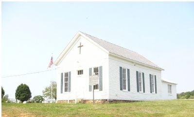
In 1850, the people of this area decided to build a church where the Word of God could be preached and expounded. Burr and Emsey Glascock donated the land and were the main leaders. Private donations by the people of the community were a large . . . — — Map (db m2332) HM
Just to the east is the original route of an ancient trail used to lay the first telegraph wire from Washington to New Orleans in 1847. During the Civil War it became a strategic military objective. It was first used by Confederate forces supporting . . . — — Map (db m237293) HM
Fourth seat of the Prince William County government. Courthouse, jail, Episcopal Chapel, and White House were built in 1822 on land originally part of the Brent Town tract confiscated from Robert Bristow, a Tory, in 1779.
♦ St. James . . . — — Map (db m780) HM
Southwest of Brentsville along Cedar Run stood "Oakland," the home of Joseph Latimer. Born in 1843, Latimer entered the Virginia Military Institute at age 16. He studied under Thomas Jackson and was first in his class. After Virginia joined the . . . — — Map (db m237421) HM
During the late summer of 1861, Confederate troops from Alabama, Mississippi, North Carolina, Tennessee, and Virginia camped in the vicinity of Bristoe Station. Typhoid, measles, and other contagious diseases quickly swept through these camps . . . — — Map (db m154871) HM
Near here is the site of the Anglican Dettingen Parish’s Broad Run Chapel which served this part of Prince William County from 1745-1758 until a new church was built on Slaty Run at Old Church Road. Though the Chapel was abandoned it was still . . . — — Map (db m218897) HM
On October 19, 1863, 12,000 Confederate and Union cavalry clashed at Buckland. Gen. J.E.B. Stuart, screening the Confederate withdrawal following the Battle of Bristoe Station, blocked the advance of Union Gen. H. Judson Kilpatrick's cavalry . . . — — Map (db m237427) HM
The town of Buckland, named for William Buckland, Architect, was chartered in 1798 with streets and lots on both sides of Broad Run near the mill of John Love. Tranquility, future site of Buckland Hall nearby, was John Love’s seat. This property was . . . — — Map (db m237430) HM
Jennie Dean (1852-1913) was born in slavery near here. A pioneer in the advancement of education and religion among the black citizens of Prince William County and neighboring counties, Miss Dean founded the Manassas Industrial School for Colored . . . — — Map (db m7618) HM
The site for the first church, a small brick building, was donated by Landon Carter of Woodland in 1822. During the battles of Manassas (Bull Run), it was used as a field hospital by both the North and the South, but was so badly damaged that it was . . . — — Map (db m874) HM
Named in honor of Benita Fitzgerald,
Olympic Gold Medalist – 100 Meter Hurdles,
XXIII Olympiad – 1984 •
Pan American Games Champion – 1983 •
U.S. National Champion – 1983 and 1986.
Benita was born in Warrenton, . . . — — Map (db m2333) HM
Here are interred members of the Glascock family of “Oak Hill.” Burr Glascock (1812–1896) brought his family here from Fauquier County in 1851. In 1870, he became the first County Supervisor from Occoquan District. His son William Beauregard . . . — — Map (db m233880) HM
On this site slaves gathered between 1861-1865. They built a brush arbor church, worshipped God and became a faithful congregation. On December 5, 1881, Rev. John L. Bell and four other church leaders purchased one acre of this land for eleven . . . — — Map (db m237294) HM
On this site once stood the first high school in eastern Prince William County. The original two-story wood frame building was built in 1914. Lightning struck and destroyed the school on June 12, 1927. It was rebuilt as a two-room brick elementary . . . — — Map (db m233885) HM
In 1954, the U.S. Supreme Court ruled that segregated schools were unconstitutional in Brown v. Board of Education. Many school systems resisted integration. Nearly ten years later many Virginia schools remained segregated. In 1964 the Prince . . . — — Map (db m206649) HM
Just east of this location along the Quantico creek was the plantation known as Graham Park. This property was patented by John Graham (1711-1787) who came to Virginia from Scotland about 1733. Graham is known as the founder of Dumfries since the . . . — — Map (db m519) HM
Between 1914 and 1953, African-American children of the surrounding area attended a two-room schoolhouse a short distance east of here along the Warrenton Turnpike. This was the final location for the Macrae School, originally established in 1870 as . . . — — Map (db m40118) HM
The town of Haymarket, chartered in 1799, owes its location to the junction of the Old Carolina Road and the north branch of the Dumfries Road at the site of the Red House. The Carolina Road developed from the Iroquois hunting path which was . . . — — Map (db m766) HM
The Carolina Road, earlier an Indian hunting path, roughly approximating Route 15 at this point, derived its name from trade between Frederick, Maryland, and Georgia. Later the road was used by settlers emigrating to western lands. Because of . . . — — Map (db m105) HM
The first of three churches, variously known as Occoquan Meeting House, Bacon Race Church, and Oak Grove Church, was built on this site c. 1774. Led by Elder David Thomas, it was Prince William County’s first Baptist Church. These churches were Old . . . — — Map (db m233876) HM
Preparatory to the Battle of Yorktown (c. 1781) General Washington ordered a troop road cut through this area to move American and French forces via the ford on the Occoquan River at Wolf Run Shoals. The road was again used during the Civil War for . . . — — Map (db m237292) HM
Near here on the Occoquan River was Selecman’s Ford, a rocky, narrow river crossing used by both sides during the Civil War. The 17th Pennsylvania Cavalry with 100 men of the 6th Pennsylvania Cavalry crossed this ford on December 19, 1862 to defend . . . — — Map (db m233890) HM
Near this site lived six generations of the Chinn family, one of Prince William County’s early African-American families. The family traces its heritage to Nancy, a slave born in 1794 on the William Roe farm in Fauquier County. William Roe’s nephew, . . . — — Map (db m233891) HM
On March 11, 1748, George Washington and George William Fairfax crossed the Occoquan above the falls near here – Washington to enter the service of Lord Fairfax, and Lord Fairfax to meet his constituents in Frederick County. They traveled by . . . — — Map (db m233853) HM
In September 1781, General George Washington directed the repair and clearing of roads leading to and from Wolf Run Shoals, the main ford of the Occoquan River, located seven miles upstream from the main ferry at Colchester. Prince William and . . . — — Map (db m233892) HM
On this site in 1961 the Whitecoff family opened the Woodbridge Airport as a general aviation field. Like many small, family-operated airports throughout the country at the time, it was constructed as a "dirt strip." As air traffic increased, . . . — — Map (db m233845) HM
Henry Lee III
"Light Horse Harry"
1756 - 1818
1776 - 1781
Cavalry Commander
1779
Awarded Congressional Medal
1786 - 1788
Member, Continental Congress
1791 - 1794
Governor of Virginia
1799 - 1801
Member, U.S. Congress . . . — — Map (db m237419) HM
Nearby are the sites of a fort ordered built in 1679, and of the oldest tomb found in the county, that of Rose Peters—1690. Iron mining was begun here as early as 1784. Remains of a colonial furnace, foundry, and mill have been discovered. . . . — — Map (db m237420) HM
A tavern originally known as Florance's Ordinary was established in this vicinity and operated by Joseph Florance in 1773 on land originally granted to John Florance in 1725. By 1786 it became known as Gaines' Tavern, being operated by William . . . — — Map (db m168451) HM
This area was known as Five Forks during the Civil War and was settled by freed slaves during Reconstruction. In 1900 a Missionary Sunday School was opened on Balls Ford Road by Miss Jennie Dean.
In 1909 this site was donated by Henritta . . . — — Map (db m20962) HM
Part of an early 18th century plantation established on Bull Run by Col. Richard Blackburn formerly of Yorkshire, England, the land was acquired by Wilmer McLean in 1854. The battle which opened 1st Manassas raged across this farm July 18, 1861, . . . — — Map (db m657) HM
After nearly four years at Appomattox Court House, Wilmer McLean and his family returned to Prince William County in 1867. McLean still owned the 985-acre Yorkshire Plantation and lived there, but wartime devastation and the end of slavery brought . . . — — Map (db m40074) HM
This land was part of a 2960-acre tract granted to Henry Walker in 1677 which he called “Walker Town.” Major Charles Ewell (c. 1713–1747) acquired 800 acres in 1739 and built “Bel Air” in 1740. The house is believed to be built on the foundations of . . . — — Map (db m233827) HM
The stone foundation and cemetery here mark the site of Prince William County's second Presbyterian Church. It was dedicated in 1855 on land donated by Oliver Chamberlin, who with Thomas Clarke and Abram Walden became the first trustees of the . . . — — Map (db m168448) HM
Nearby is Bel Air Plantation (c. 1740), burial site of Parson Mason Locke Weems, first biographer of George Washington. French and American troops moved through this community on their way to Yorktown in 1781. Northern dairymen developed large farms . . . — — Map (db m233844) HM
Originally located in the Independent Hill area, this house was built in 1797. Capitalizing on its location on one side of Prince William County's main east-west roads, the Adams family converted the house into a tavern for travelers. Later in . . . — — Map (db m168445) HM
Allison Maddox (ca. 1760-1843), a veteran of the Revolutionary War from Charles County, Maryland, purchased this property in 1810 from James E. Heath. The Maddox family cemetery, situated well inside the tract, is typical for a small farmstead of . . . — — Map (db m237291) HM
Prince William militia opened a road nearby in preparation for the Yorktown Campaign of 1781. French and American cavalry, wagon trains, and cattle unable to use the ferry at Woodbridge, traveled this road, fording the river at Wolf Run Shoals on . . . — — Map (db m233896) HM
Thru this village in January, 1779 passed the British and Hessian troops captured at the Battle of Saratoga on their way to prisoner of war camps located near Charlottesville. Later on June 5, 1781 General Anthony Wayne brought his brigade of the . . . — — Map (db m4362) HM
A stone foundation and graveyard mark the site of Prince William County's first Presbyterian Church which was established in 1848 on land donated by the Kline family. Buried within the cemetery are the Presbyterian founders, a Methodist minister, . . . — — Map (db m143105) HM
Nathaniel Ellicott formally established the town in 1804, bringing to fruition industrial and commercial developments begun 'at or near the Falls of Occoquan' by John Ballendine c. 1750. The estuary of The Occoquan has attracted the attention of . . . — — Map (db m122460) HM
In 1758 when John Ballendine built his dwelling, “Rockledge,” at Occoquan, the town began to prosper. By 1765 it was a flourishing industrial settlement with grist mills, foundry, and tobacco warehouses. “Rockledge” and a . . . — — Map (db m114) HM
The Federal style stone, “Manor” house and its accessory buildings are the visible reminders of Ben Lomond Farm, which was begun in about 1830 by Benjamin Tasker Chinn, the grandson of Robert “Councillor” Carter. Ben . . . — — Map (db m43313) HM
Families of African-American, Native American, and mixed ancestry migrated here from Fauquier, Culpeper, Rappahannock and Warren Counties after the Civil War. The Allen, Berry, Fletcher, Nickens, and Peyton families, along with former slaves from . . . — — Map (db m974) HM
Quantico, the Algonquian term for the once navigable creek to the port of Dumfries, lends its name to the Marine Corps installation established in 1917 and to the Potomac River town chartered in 1927. Early land patents date to 1654. . . . — — Map (db m40092) HM
In 1653, Thomas Burbage obtained 3,000 acres between the Occoquan and Neabsco Creek. Burbage’s Neck later passed to Martin Scarlet (d.1695), pioneer settler and sometime Burgess. George Mason II gained 534 acres of Occoquan River frontage including . . . — — Map (db m2336) HM
To the east is the only preserved segment of the Potomac Path, the earliest north-south route in northern Virginia. Following an ancient Indian trail, the road, later known as the King's Highway, assumed great importance for overland travel between . . . — — Map (db m2164) HM
Noted for his cratsmanship on the first Falls Church and other structures for prominent landowners, to include the Washington family. Richard Blackburn (1710-1757) built Rippon Lodge as his main estate house circa 1747. Richard's son, Thomas . . . — — Map (db m131560) HM
William Grayson, lawyer, member of the Continental Congress, Constitutional Convention and U.S. Senate, is buried nearby on property formerly part of “Belle Air,” the family plantation. In 1774, Grayson organized Prince William County’s . . . — — Map (db m770) HM