By James R. Murray, August 11, 2016
Alton New Hampshire Civil War Memorial
| On Main Street (Route 11), on the right when traveling north. |
| On Main Street (New Hampshire Route 11), on the right when traveling north. |
| On Main Street (New Hampshire Route 11), on the right. |
| On Main Street (New Hampshire Route 11), on the right. |
| On Rt. 11 (New Hampshire Route 11), on the right. |
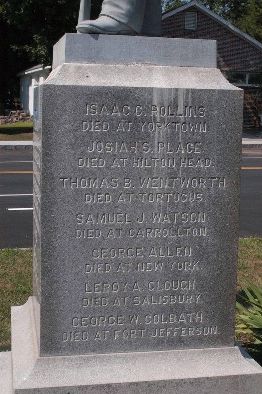
| On S Barnstead Road (New Hampshire Route 126) north of Gray Road, on the left when traveling north. |
| On Main Street, 0.1 miles south of Plymouth Street (New Hampshire Route 25B), on the right when traveling north. |
| On New Hampshire Route 25, on the right when traveling south. |
| On New Hampshire Route 107, on the right when traveling north. |
| Near Endicott Street (U.S. 3) east of Lakeside Avenue, on the right when traveling west. |
| On Endicott Street (U.S. 3) east of Lakeside Avenue, on the right when traveling west. |
| On Main Street, on the right when traveling south. |
| On Park Street (New Hampshire Route 132) at Dearborn Road, on the right when traveling north on Park Street. |
| On Sargent Street at Park Street (New Hampshire Route 132), on the right when traveling east on Sargent Street. |
| On West Main Street (U.S. 3) 0.2 miles west of Deer Street, on the right when traveling west. |
| On West Main Street (U.S. 3) at Winter Street, on the right when traveling west on West Main Street. |
| Near West Main Street (U.S. 3) at Winter Street, on the left when traveling west. |
| Near West Main Street (U.S. 3) at Winter Street, on the left when traveling west. |
| Near West Main Street (U.S. 3) at Winter Street, on the left when traveling west. |
| On Main Street (U.S. 3) at School Street, in the median on Main Street. |
| On Passaconaway Road east of Kancamagus Highway (New Hampshire Route 112), on the right when traveling east. |
| Near Passaconaway Road east of Kancamagus Highway (New Hampshire Route 112) when traveling east. |
| On Main Street (U.S. 302) at Albany Avenue, on the left when traveling west on Main Street. |
| On Main Street at Albany Avenue, on the left when traveling west on Main Street. |
| On Main Street (U.S. 302) at River Street, on the right when traveling east on Main Street. |
| On Crawford Notch Road (Route 302), on the right when traveling south. |
| On West Side Road, 2.2 miles north of River Road, on the left when traveling south. |
| On Chocorua Mountain Highway (New Hampshire Route 16) 0.8 miles north of Chocorua Lake Road, on the left when traveling north. |
| On New Hampshire Route 112, 0.3 miles west of Moat View Drive, on the right when traveling west. |
| On West Side Road at Hillside Avenue, on the right when traveling north on West Side Road. |
| On Skimobile Road, on the right when traveling east. |
| On Intervale Cross Road, 0.2 miles east of White Mountain Highway (U.S. 302), on the left when traveling east. |
| On U.S. 302, 0.1 miles south of Hurricane Mountain Road, on the right when traveling south. |
| On Route 302, on the right when traveling north. |
| On U.S. 302 west of White Mountain Road (New Hampshire Route 16), on the left when traveling west. |
| On Crawford Notch Road (U.S. 302), on the right when traveling north. |
| On Crawford Notch Road (U.S. 302) west of White Mountain Road (New Hampshire Route 16), on the right when traveling east. |
| On Crawford Notch Road (U.S. 302) 1 mile north of Willey House Station Road, on the left when traveling north. |
| On Main Street (New Hampshire Route 16A) at Carter Notch Road (New Hampshire Route 16B), on the right when traveling east on Main Street. |
| On Main Street (New Hampshire Route 16A) at Pinkham Notch Road (New Hampshire Route 16), on the right when traveling west on Main Street. |
| On East Madison Road at Village Road (New Hampshire Route 113), on the left when traveling south on East Madison Road. |
| Near Norcross Circle, 0.1 miles west of White Mountain Road (U.S. 302). |
| Near Norcross Circle, 0.1 miles west of White Mountain Road (U.S. 302). |
| Near Norcross Circle, 0.1 miles west of White Mountain Road (U.S. 302). |
| Near Norcross Circle, 0.1 miles west of White Mountain Road (U.S. 302). |
| Near Norcross Circle, 0.1 miles west of White Mountains Road (U.S. 302). |
| Near Norcross Circle, 0.1 miles west of White Mountains Road (U.S. 302). |
| Near Norcross Circle, 0.1 miles west of White Mountains Road (U.S. 302). |
| Near Norcross Circle, 0.1 miles west of White Mountains Road (U.S. 302). |
| On White Mountain Road (U.S. 302) at Kearsarge Road, on the right when traveling north on White Mountain Road. |
| Near Norcross Circle, 0.1 miles west of White Mountains Road (U.S. 302). |
| On White Mountain Road (U.S. 302) at Norcross Circle, on the right when traveling south on White Mountain Road. |
| On Norcross Circle, 0.1 miles west of White Mountain Highway (U.S. 302), on the right when traveling south. |
| Near Norcross Circle at White Mountain Road (U.S. 302). |
| Near Norcross Circle, 0.1 miles west of White Mountains Road (U.S. 302). |
| Near Norcross Circle, 0.1 miles west of White Mountains Road (U.S. 302). |
| On White Mountain Highway (New Hampshire Route 16) at New Hampshire Route 16B, on the right when traveling north on White Mountain Highway. |
| On Tamworth Road (New Hampshire Route 113) at Main Street, on the left when traveling east on Tamworth Road. |
| On Tamworth Road (New Hampshire Route 116) near Main Street, on the left when traveling east. |
| On New Hampshire Route 109, on the right when traveling north. |
| On New Hampshire Route 109 at Lake Road, on the right when traveling east on State Route 109. |
| On North Main Street (New Hampshire Route 109) at Lang Pond Road, on the right when traveling north on North Main Street. |
| On Center Street just north of Willow Street, on the right when traveling north. |
| On South Main Street (New Hampshire Route 109) at Center Street (New Hampshire Route 28), on the right when traveling east on South Main Street. |
| Near Center Street (New Hampshire Route 28) 0.1 miles north of Willow Street, on the left when traveling north. |
| On Chinook Trail (New Hampshire Route 113A). |
| On Hinsdale Road (New Hampshire Route 119) at Gun Mountain Road, on the left when traveling west on Hinsdale Road. |
| On Local Route 63, 0.1 miles north of Old Chesterfield Road, on the right when traveling north. |
| On New Hampshire Route 9A at Joslin Street, on the right when traveling west on State Route 9A. |
| On Franklin Pierce Highway (New Hampshire Route 9) at Pond Brook Road, on the right when traveling west on Franklin Pierce Highway. |
| On New Hampshire Route 119 at Templeton Turnpike, on the left when traveling south on State Route 119. |
| On New Hampshire Route 119 west of Templeton Turnpike, on the left when traveling west. |
| On Templeton Turnpike, 0.1 miles south of New Hampshire Route 119, on the left when traveling south. |
| On Canal Street (New Hampshire Route 119) 0.5 miles east of Chesterfield Road (New Hampshire Route 63), on the left when traveling east. |
| On Canal Street (New Hampshire Route 119) at Depot Street, on the right when traveling east on Canal Street. |
| On Canal Street (New Hampshire Route 119) at Depot Street, on the right when traveling east on Canal Street. |
| On Main Street (New Hampshire Route 119) just west of Depot Street, on the left when traveling west. |
| On Canal St., on the right when traveling east. |
| On Canal St., on the right when traveling east. |
| On Canal Street (New Hampshire Route 119) 0.5 miles east of Chesterfield Road (New Hampshire Route 63), on the left when traveling east. |
| On Canal Street (New Hampshire Route 119) at Depot Street, on the right when traveling east on Canal Street. |
| On Church Street at Main Street, on the left when traveling west on Church Street. |
| Near West Street at Federal Street. |
| On Main Street at Wyman Way, on the right when traveling north on Main Street. |
| On Main Street (New Hampshire Route 12) at Manchester Street, on the right when traveling north on Main Street. |
| On Railroad Street just east of Main Street, on the right when traveling east. |
| On West Street at St. James Street, on the right when traveling east on West Street. |
| On Washington St., on the right when traveling south. |
| On Main Street at Roxbury Street, in the median on Main Street. |
| On Main Street at Railroad Street, on the right when traveling north on Main Street. |
| On Main Street at Winchester Street, on the right on Main Street. |
| On Main St. (New Hampshire Route 12) 0.1 miles north of Rte. 101E and Hwy. 12, on the right when traveling south. |
| On Main Street (New Hampshire Route 12) north of Gates Street, on the right when traveling north. |
| On Main St. (New Hampshire Route 12) at Baker Street, on the right when traveling north on Main St.. |
| On Cheshire Rail Trail at Main Street, on the left when traveling west on Cheshire Rail Trail. |
| On Central Square at Washington Street, on the right when traveling west on Central Square. |
| On Winchester Road (New Hampshire Route 119) 0.1 miles west of Athol Road (New Hampshire Route 32), on the left when traveling west. |
| On Franklin Pierce Highway (New Hampshire Route 9), on the right when traveling east. |
785 entries matched your criteria. The first 100 are listed above.
Next 100 ⊳