(East Face):
Tribute dedicated to the memory of the soldiers who gave their lives in the defense of our country here at Fort Morgan.
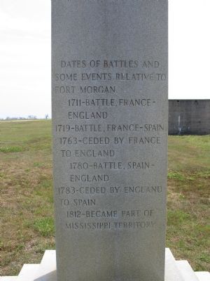
Here lies the pride of seven flags entombed in our ancestor’s worth, who heard the thunder of the fray . . . — — Map (db m4649) HM
At, or near, this site, the United States, after seizing this point of land from the Spanish in 1813, built Fort Bowyer, a structure of wood and sand.
A small garrison of men courageously fought to defend the fort against two British attacks, one . . . — — Map (db m187339) HM
On this site stood the St. Julian Hotel where Jefferson Davis and his daughter Winnie, spent the night and where he spoke to the people of Eufaula, March 9, 1886. — — Map (db m185917) HM
Ogly-Stroud Massacre
William Ogly built his cabin near this site at Poplar Springs along the Federal Road, and was killed here with most of his family on March 13, 1818. His friend Eli Stroud's wife was fatally wounded and their infant . . . — — Map (db m120933) HM
In erecting this marker the Clarke County Historical Society's sole purpose is to mark events and areas affecting the county's history.
Beat 15 of Clarke County, since the mid 19th century, came to be known as Mitcham Beat, named for an early . . . — — Map (db m203677) HM
This sculpture is dedicated to the many individuals whose efforts made Muscle Shoals and the Muscle Shoals area the “Hit Recording Capital of the World,” and to those who continue that legacy.
Legend of the Singing River
The . . . — — Map (db m167279) HM
Old courthouse clock bell from 1897 to 1917
has been donated to Covington County
this Bicentennial year 1976
by H. Speller Moates and family.
Dedicated to the early settlers of Covington County
Erected in honor of
the . . . — — Map (db m94205) HM
A tribute to the citizens of
Cullman County for
bending, but not breaking, following
the EF4 tornado on April 27, 2011.
Dedicated: April 27, 2013
Designed by: Cullman City Street Dept. — — Map (db m101094) HM
The Cullman County native was the first
man drafted in America for World War I. His
Selective Service number 258, was the first
one drawn in the U.S. Senate Building in
Washington D.C. on July 20, 1917. 10,500 men
were drafted that . . . — — Map (db m101097) HM
"This was a glorious fight, one that did the soldiers' hearts good to look upon, made there in the mountains in the darkness of the night, almost hand-to-hand, with only the light from the vivid flash of the artillery and . . . — — Map (db m101089) HM
"The thanks of Congress are again due to General N. B. Forrest and the officers and men of his command, for meritorious service in the field, and especially for the daring, skill, and perseverance exhibited in the pursuit . . . — — Map (db m101090) HM
On a May afternoon in 1856, an angry
John A. Bell rounded this corner
carrying a large hickory stick. He passed
by Edward Perine's fine brick store, and
continued south down the sidewalk.
Under his coat, he carried two pistols
and a . . . — — Map (db m112527) HM
A shallow offshore area of the ancient Gulf of Mexico eventually became the land upon which downtown Wetumpka was built and through which today's Coosa River flows. This area also was the site of Alabama's greatest natural disaster and the "bull's . . . — — Map (db m222632) HM
You are on the northwestern rim of the Wetumpka Impact Crater. In this area of
the crater rim, there are several man-made cuts into the metamorphic bedrock.
Mica schist forms the bedrock in this area down to depths of several thousand feet. After . . . — — Map (db m189013) HM
The beautiful vista across the Wetumpka Impact Crater is best seen
from the highest point on the northwestern rim here at Bald Knob.
A favored area for communication towers, Bald Knob is almost 600
feet above sea level. Looking down the power . . . — — Map (db m189019) HM
You are on the crater floor inside the western rim of the Wetumpka Impact Crater, in an area called the "cliffs." After the meteor's impact, there was a massive landslide from the southern rim that brought vast quantities of clay and sandy sediment . . . — — Map (db m189021) HM
This section of Buck Ridge Road is unusual because you can easily see hills created on both sides of the road that are related to the impact of a large meteor 85 million years ago. These hills contain large boulders that came to rest near the . . . — — Map (db m189024) HM
Because of the cleared natural gas pipeline, this area provides an excellent view
of the eastern rim of the Wetumpka Impact Crater. The notch on the far rim is
over a mile away. On the west side of Trotters Trail (behind you) the high point
is . . . — — Map (db m189029) HM
From a distance, one of the best vistas of the Wetumpka Impact Crater is from the Wetumpka Sports Complex. Your view here is of the highest remains of the northwestern rim of the crater. In the center, several communication towers are located on . . . — — Map (db m189035) HM
The rock layers here in the Coosa River are part of
the deeply eroded western rim of the Wetumpka
Impact Crater. The Coosa River curves around the
rim in the downtown area and these rock layers tilt
away from the crater center, typical of . . . — — Map (db m189038) HM
Wetumpka Timeline (Prehistory – 1924)
85 Million Years Ago
A meteor strikes Wetumpka during the age
of the dinosaurs creating a five-mile wide
impact crater blasted into the bedrock.
1714
At the invitation of the Creeks and . . . — — Map (db m222651) HM
The Eleventh Street School, built in 1907, was one of the earliest elementary schools in Gadsden. It is the only local surviving school building of that era.
This two-story red brick structure has solid masonry exterior walls and an entrance which . . . — — Map (db m83734) HM
The North Alabama Conference of the United Methodist Church was organized on this site in the Methodist Episcopal Church, South of Gadsden, Alabama
November 16, 1870
Bishop Robert Paine, presiding
The Centennial Convocation of the Conference . . . — — Map (db m83739) HM
Ashford was incorporated on June 22, 1891. Citizens, friends, and families of Ashford gathered here on June 22, 1991, to remember Ashford's durable and progressive history. This commemoration also affirmed their faith in Ashford's future by placing . . . — — Map (db m73411) HM
The story of “steel drivin’ man” John Henry is one of America’s most enduring legends. The strong ex-slave became a folk hero during construction of the Columbus & Western Railroad between Goodwater and Birmingham. He drilled holes for . . . — — Map (db m22207) HM
About 1800 Doublehead located his village at this site, where his brother-in-law Tahlonteeskee had previously lived. Doublehead's log house was built along the same style of those of the white settlers. Chief Doublehead had previously led raids . . . — — Map (db m83942) HM
The notorious outlaw gang leader who boasted that no one would ever run over Tom Clark lies buried near the center of Tennessee Street where now all who pass by do run over him. In 1872, Clark, who terrorized helpless citizens during the Civil War, . . . — — Map (db m80320) HM
Construction of this road, as ordered by General Andrew Jackson, began in May 1817 by troops of the U.S. Army for national defense purposes. Beginning near Nashville, Tennessee and continuing to Madison, Louisiana, it shortened the distance from . . . — — Map (db m80321) HM
Dr. E. B. Norton was a member of the U.S. Education Mission sent to Japan after World War II to advise Gen. McArthur on the complete reorganization of the Japanese School System, which is still in place today. — — Map (db m219325) HM
After flying more than 90 worldwide reconnaissance missions, in 1990 Lt. Col. Ed Yeilding set a coast to coast aircraft speed record of 67 minutes 54 seconds flying an SR-71 spy plane, which is now at the Smithsonian. — — Map (db m219174) HM
Side A This area near the mouth of Cypress Creek was inhabited by Archaic People as early as 8,000 B.C. Their main food consisted of freshwater mollusks from the river.
(These mussels were the origin of the name "Muscle Shoals.")
The . . . — — Map (db m84044) HM
Known as the "Father of Rock and Roll,"
Sam Phillips established Sun Records in 1952, helping Elvis Presley and other well-known artists launch their careers. He received a Grammy for Lifetime Achievement in music. — — Map (db m219189) HM
The University of North Alabama became the first school in the history of NCAA scholarship football to win three consecutive national championships (1993, 1994, and 1995). Under Coach Bobby Wallace, UNA posted a 41~1 record over the same three ~ . . . — — Map (db m32765) HM
Thousands of Cherokee Indians passed through Waterloo in the 1830s when they were forced by the U.S. government to move West on the "Trail of Tears". Most came by boat from Tuscumbia and camped here to await transfer to larger steamboats. During the . . . — — Map (db m84301) HM
Five Historic Indian tribes lived in this area. By 1701, The Yuchi were living at the shoals on the Tennessee River. In early 1700s the Yuchi left, some moving to the Cherokee Nation on the Hiwassee River, TN and others to Chattahoochee River, GA. . . . — — Map (db m36040) HM
Coming of the railroad from Montgomery in 1845 started a new era, with Loachapoka's name revived. It became the trade center for Waverly, Roxana, Rome, Camp Hill, Dudleyville, and Dadeville.
Rousseau's Raiders hit Loachapoka at sun down, . . . — — Map (db m31356) HM
Lynching in America
Thousands of black people were the victims of lynching and racial violence in the United States between 1877 and 1950. The lynching of African Americans during this era was a form of racial terrorism intended to . . . — — Map (db m97983) HM
Samuel "Sammy" Leamon Younge, Jr. (1944-1966), a civil rights and voting rights activist, was the first African American university student killed during the civil rights movement. A Tuskegee native, Younge was attending Tuskegee University when . . . — — Map (db m139875) HM
In August of 1963, the United States District Court M. D. Alabama sided with the plaintiff in Lee v. Macon County Board of Education. This pivotal civil rights case involved the integration of, the all-white Tuskegee High School (located on . . . — — Map (db m139878) HM
Charles Goode Gomillion (1900-1995) was born on April 1, 1900, in Johnston, South Carolina. He joined the faculty at Tuskegee University in 1928, where he served as dean of students and chair of the social sciences department. He was president of . . . — — Map (db m140006) HM
In May 1838 soldiers, under the command of U.S. Army General Winfield Scott, began rounding up Cherokee Indians in this area who had refused to move to Indian Territory in Oklahoma. About 16,000 Cherokees were placed in stockades in Tennessee and . . . — — Map (db m33318) HM
Before statehood, the Alabama Territory had only limited rights of self government. Between July 5 and August 2, 1819, forty-four delegates from across the Territory convened in Huntsville to draft a constitution for statehood. Lawyers, merchants, . . . — — Map (db m26592) HM
Side A Organized to enhance the economic growth and well~being of the community in order to provide employment opportunities and a superior quality of life for local residents.
First known as the Huntsville Chamber of Commerce, the . . . — — Map (db m234324) HM
The Tree of Pau
Presented to the people of Mobile
from their sister city, Pau, France.
Symbolic of the restoration after
Hurricane Frederic 1979. — — Map (db m86439) HM
On this site stood the home of Mayor Samuel H. Garrow, where the Marquis de Lafayette was entertained on his visit to Mobile, April 7, 1825. Lafayette, French officer, statesman, and hero of the American Revolution, visited the United States as . . . — — Map (db m86420) HM
Although having a very small military, Luxembourg sent a 44-man volunteer infantry platoon to Korea in November 1950. This unit served as part of the Belgium Battalions who were assigned to the U.S. 3rd Infantry Division throughout the war. The . . . — — Map (db m192094) WM
On March 21, 1981, 19-year-old Michael Donald was abducted, beaten, killed and hung from a tree on this street by members of the Ku Klux Klan. He was randomly selected in retaliation for an interracial jury failing to convict a black man for killing . . . — — Map (db m111384) HM
Greek immigrant Christopher Anastasios Katechis opened Chris’ Hot Dogs on May 1, 1917, at 138 Dexter Avenue. Until the 1960’s, Chris offered curb service for its hot dogs, leading to long lines of cars cued for service. The hot dogs featured Chris’ . . . — — Map (db m103243) HM
Georgia Gilmore, cited as a “solid energetic boycott participant and supporter.” Lived in this house during the days of the Montgomery Bus Boycott. Once arrested on a bus, Gilmore was ardent in her efforts to raise funds for the Movement . . . — — Map (db m28197) HM
Front Between May 20-24, 1961 Dr. Harris opened this home to a group of 33 students from Nashville, Tennessee, who were challenging interstate bus segregation. Known as the Freedom Riders, the group was attacked at the historic Montgomery . . . — — Map (db m86119) HM
On December 13, 1878, a meeting was held in Montgomery for the purpose of forming a bar association, and on January 15, 1879, delegates from each county met for five days at a preliminary conference in the Hall of the House of Representatives. The . . . — — Map (db m86121) HM
In the 17th and 18th centuries, 12 million African people were kidnapped, chained, and brought to the Americas after a torturous journey across the Atlantic Ocean. Nearly two million people died during the voyage. The labor of enslaved black people . . . — — Map (db m118044) HM
The Great Hartselle Bank Robbery In the early morning hours of Monday, March 15, 1926, bandits pulled off one of the most brazen bank robberies in the history of Alabama. In a well-planned operation, a band of five to ten men took around $15,000 . . . — — Map (db m217091) HM
Erected By
The Cadet Corps 1923-1924
Cadets
Jefferson Bryant Meharg
and
Lawrence Christopher Olsen
who lost their lives
in the burning of college barracks
March 17, 1924
"Greater love hath no man than this, . . . — — Map (db m116917) HM
Fort Mitchell served as a primary point of concentration for creeks being sent westward to Indian Territory before, during, and after the Second Creek War (1836-1837). By the terms of the 1832 Treaty of Washington, Creek heads of household and . . . — — Map (db m101840) HM
In 1870 St. Clair Co. was still under Radical Republican Reconstruction. On August 20, 1870 honorable men of the County (former Confederates) had decided to hold the first Democratic Convention after the War Between the States. The meeting would be . . . — — Map (db m28142) HM
Stars Fell On Alabama
November 30, 1954. It was a cold, clear early afternoon when Dr. Moody Jacobs left his office for lunch. In the sky, he saw a trail of dark smoke and heard an explosion before white smoke shot out in several directions. . . . — — Map (db m44229) HM
The Trail of Tears led thousands of Creek Indians through Tuscaloosa, capital of Alabama in 1836. Chief Eufaula addressed the legislature with these words:
"I come here, brothers, to see the great house of Alabama and the men who make laws and . . . — — Map (db m119308) HM
Foster Auditorium is the site of the June 11, 1963, “stand in the schoolhouse door” by Governor George C. Wallace in defiance of a court order requiring The University of Alabama to admit African-American students Vivian Malone and James . . . — — Map (db m37917) HM
Visionary
An ardent expansionist, Seward pursued his vision of “Manifest Destiny” to expand the borders of the United States through peaceful means. Some of his interests included a port in the Caribbean, Hawaii, Guam, British Columbia, and . . . — — Map (db m181745) HM
On October 18, 1867, the Russian eagle ceded its perch on this hill to the American eagle.
What a Deal!
By the 1860s, the Russian-American Company (RAC), which managed Russia's colonies in Alaska, was losing money, so Russia decided to sell . . . — — Map (db m181361) HM
The first American flag was raised by a colorguard from Company F, 9th Infantry, to signify the transfer of Alaska from czarist Russia.
The first 49 star American flag was raised on July 4, 1959, by a colorguard from the First Battle Group 9th . . . — — Map (db m133863) HM
Frank Reid, guarding the approach to Sylvester's Wharf, where the vigilantes were meeting to restore law and order, shot "Soapy Smith" who failed to stop when challenged, July 8, 1898. — — Map (db m72790) HM
[Seal of the Royal Canadian Mounted Police] In Commemoration of Inspector Charles Constantine and Staff Sergeant Charles Brown North West Mounted Police First members of this historic Canadian police force who landed at Skagway, Alaska . . . — — Map (db m69014) HM
In 1899, 14 year old Bertha Wahl was murdered here by a shepherd. Just south of here was the original Becker Store. Beyond lie the graves of the Becker family. Due west stood Henry Springer's Mercantile. — — Map (db m36647) HM
On Dec. 25, 1886, James Hale was gunned down here in front of the Brighton Saloon. His accused was never brought to trial. In 1894 this site, then called Hunter's Hall, held the first Presbyterian services in the Round Valley. — — Map (db m36651) HM
At this location on June 5, 1933, First Lady Eleanor Roosevelt, wife of President Franklin Delano Roosevelt, dedicated Douglas International Airport as the first international airport in the United States.
Designed by J. P. Sexton as the first . . . — — Map (db m28357) HM
Spanish:
En el año 1539, recordando aún el anuncio de la conquista del imperio inca que occurrió en 1533, el virrey Antonio de Mendoza receloso pero con te a la vez, envió a un sacerdote para comprobar los rumres [rumores] sobre ricas . . . — — Map (db m28255) HM
Bob Hatch and John Campbell opened a billiard parlor in 1880. Bob Hatch was a colorful character and an amateur thespian. It was said he kept a jar of frogs on the counter as their croaking helped him predict the weather. He followed the Earps to . . . — — Map (db m48516) HM
The devastating fires of 1881 and 1882 brought major changes to the Tombstone Fire Department. A new fire station was completed in 1881, a new Rescue Hook and Ladder Co. was formed, and a new water source was obtained. Thirty six miles of fifteen . . . — — Map (db m53403) HM
Named for a pine tree stripped of its branches by a party of immigrants and used as a flagpole for a patriotic celebration on July 4, 1876. Nearby Antelope or Old Town Spring provided water and led to the establishment of a railroad construction . . . — — Map (db m33330) HM
Flags have been important to the history of Flagstaff. It was a pine tree used as a flag staff that gave the town its name when Old Glory was flown at a spring (that later became the site of Flagstaff) on the occasion of the nation's . . . — — Map (db m33338) HM
This fountain is dedicated to the memory of our fellow employees who died October 8, 1997 in a plane crash near Montrose, Colorado.
Their names encircle the fountain just as the accomplishments of their careers and lives encircle us. . . . — — Map (db m40325) HM
One of the West’s Longest and Bloodiest feuds took
place here and around Pleasant Valley. The Grahams and
the Tewksburys had been in the cattle business and it
seems probable that they first fell out over the division of cattle they jointly . . . — — Map (db m78742) HM
The 740th tank battalion was activated at Fort Knox, Ky. on March 1, 1943. It trained at Fort Knox and at Camp Bouse, Az. as a canal defense light (CDL) unit and as a standard medium tank battalion from October 15, 1943 to April 24, 1944 then sailed . . . — — Map (db m78562) HM
This boxcar is one of 49 that comprised the French Gratitude Train. Once filled with 50 tons of gifts, the Gratitude Train was a way for the people of France to say “Thank You” to the American people for their help during and after World . . . — — Map (db m126700) HM WM
In Memory of
Our Hualapai Ancestors
Who Fought Against Cultural Genocide
With Bravery and Foresight
They Sacrificed Their Lives
So The Hualapai People's
Survival May Continue
Today And Forever…
This location was a . . . — — Map (db m36013) HM
"O Lord, thou givest us everything at the price of an effort."
Leonardo Da Vinci
1452-1519
We remember
those who gave their
lives in the Holocaust of
July 5, 1973, in Kingman
John O. Campbell • Allan Hanson • Christopher G . . . — — Map (db m29421) HM
"We are now friends with England and with all Mankind."
Written by Benjamin Franklin, American Peace
Commissioner in Paris, following the signing of the peace treaty ending the American Revolution
September 1783
With American and . . . — — Map (db m31843) HM
Opened By
The Right Honorable The Lord Mayor Of London
Alderman Sir Peter Studd G.B.E.M.A.D.Sc.
In The Presence Of
The Honorable Jack Williams
Governor Of Arizona
October 10, 1971
Robert P. McCulloch Sr C.V. Wood Jr. . . . — — Map (db m4328) HM
The Old Spanish Trail, the main trade route between Santa Fe and Los Angeles, passed this way beginning in 1829. At the end of the Mexican-American War this portion of the route evolved into what was variously known as the Salt Lake Road, the . . . — — Map (db m78535) HM
The petrified wood strewn in the valley below was once encased in the bluffs around you. When erosional forces removed the softer rocks, the petrified wood tumbled and accumulated on the valley floor. Once filled with fallen logs, Jasper Forest was . . . — — Map (db m68871) HM
A solstice is an astronomical event that happens twice annually as the Sun reaches its highest or lowest point in the sky. Here in the Northern Hemisphere, June 20th is usually the longest day of the year and is referred to as the summer solstice. . . . — — Map (db m68888) HM
In 1876, Corydon E. Cooley and Marion Clark, two ranchers who had both laid claim to, and eventually became partners in managing 100,000 acres of land at the northwest edge of the White Mountains determined that the land could not support two . . . — — Map (db m36664) HM
Near this site on December 16 – 17, 1846, the U.S. 101st Infantry ("Mormon") Battalion under the command of Colonel Philip St. George Cooke peacefully occupied the Presidio San Agustin del Tucson.
Organized in Council Bluffs, Iowa, to . . . — — Map (db m73983) HM
Born Segno, Italy, 1645 – Educated at Jesuit Colleges
Entered society of Jesus, 1665 – His petition to be sent upon
a distant and dangerous mission granted, 1678 – Began missionary labors in Lower California, April 1, 1683 . . . — — Map (db m26394) HM
Honoring the young men who served in the Civilian Conservation Corps here and across the nation. With shovel and hammer, trowel and chisel, they moved earth, planted trees, crafted stone, and built structures that shape our landscape and remain a . . . — — Map (db m30614) HM
Who camped here Dec 20, 1846
in rout to Cal. War with Mexico.
Erected By
Aaronic Priesthood Mesa 3rd Ward L.D.S.C.
Troop 57 Boy Scouts of America R.C.
Hugh Dana Sp.• Joseph Moody S.M. •
F.K. Pomeroy 1st Coun • T. Elmer Hastings Asst . . . — — Map (db m27207) HM
The Gila River north of this site marked the international border of the United States and Mexico from 1848 to 1854. James Gadsden negotiated to purchase 38,000 sq. miles of "wild country" for $15 million in gold. Amended to $10 million for 29,640 . . . — — Map (db m33689) HM
The Gila River north of this site marked the international border of the United States and Mexico from 1848 to 1854. James Gadsden negotiated to purchase 38,000 sq. miles of "wild country" for $15 million in gold. Amended to $10 million for 29,640 . . . — — Map (db m33692) HM
From a Sycamore near this spot, L.V. Grime and C.B. Hawley were lynched on Aug. 24, 1882 for the hold up – murder of Andrew Hall, Wells Fargo Packer, and Dr. S.T. Vail. The culprits had a fair hearing before JP Allen on Wednesday eve, and at 2 . . . — — Map (db m34116) HM
Dedicated to
Ira H. Hayes USMC
February 23rd 1992
by the Memorial Committee
Lance Lewis Director,
Shirley Lewis Coordinator
JR Currea Artist
In Country Vietnam Veterans
Post 2 Tempe Arizona
Ira H. Hayes American . . . — — Map (db m32845) WM
2912 entries matched your criteria. The first 100 are listed above. Next 100 ⊳