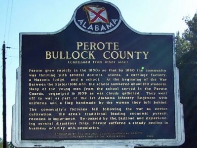
This community, settled during the mid-1830s, was first called Fulford’s Cross Roads, then Missouri Cross Roads when a post office was established here in 1846. The name Perote, adopted in 1850 was suggested by veterans returning from the Mexican . . . — — Map (db m83256) HM
Brigadier General C.S.A.
With Army of Virginia 1861-1865.
Wounded in battle five times.
He was one of four distinguished sons
of Jacob Forney and Sabina Swope Hoke
of Jacksonville who held commissions
in the Confederate Army.
. . . — — Map (db m36480) HM
Brigadier General Birkett Davenport Fry, CSA
(1822-1891)
In his lifetime General Birkett D. Fry was a cadet at Virginia Military Institute and West Point; 1st Lt. (U.S. Infantry) in Mexican War; lawyer in California; mercenary-soldier of . . . — — Map (db m95112) HM
Seminole Wars
1814-1858
I am Private Pet Younger of the 4th US Infantry Regiment. I joined the Regular Army in November 1835 at age 15. I was specially trained as part of the light infantry company whose main jobs were scouting and . . . — — Map (db m85604) WM
Earliest visitors to the region now known as Winfield were bands of Chickasaw Indians who frequented this area as a hunting ground. The abundant wildlife of the Appalachian foothills made this area attractive to early hunters. After the Chickasaw . . . — — Map (db m85847) HM
A graduate of West Point Military Academy, he served the United States as Colonel of Mississippi Volunteers, Mexican War; member of House of Representatives, Senator, and as Secretary of War. Inaugurated President of the provisional government, . . . — — Map (db m155530) HM
Built by James J. Gilmer. Purchased by Reuben C. Shorter, 1849, for his wife, Caroline A.V. Billingslea, who later married Tennent Lomax, captain and governor of Orizaba, Mexican War colonel, 3rd Ala. Infantry Regt., CSA, killed at Battle of Seven . . . — — Map (db m86128) HM
167th Infantry An Alabama regiment was formed in 1836 to defend Fort Foster in Florida. Same unit, designated the 1st Alabama Volunteers ten years later, served in Mexican War. Mustered again May 4, 1861 as the 4th Alabama Infantry Regiment, . . . — — Map (db m38897) HM
This area's first settlers arrived in the 1830s and established the Crossroads community at the intersection of the Columbus-Tuscaloosa and Vienna-Fayette stagecoach roads, one mile northeast of Gordo's present location on Highway 82. The name . . . — — Map (db m152577) HM
Near here was the home of Confederate Brigadier General James Cantey who arrived in 1849 to operate a plantation owned by his father. Prior to coming to Russell County he had practiced law at his birthplace, Camden, South Carolina, and had . . . — — Map (db m81715) HM
He presided over the transfer of the capital from Tuscaloosa to Montgomery in 1847. When the United States invaded Mexico Alabamians readily joined to fight, just as they would in 1861. — — Map (db m29034) HM
Cordova, Alabama, located in Walker County on the Mulberry Fork of the Black Warrior River, was founded in 1859 by Captain Benjamin McFarland Long. He named the town after one in Mexico where he served under Robert E. Lee during the Mexican War . . . — — Map (db m43145) HM
This is the M1841 Mountain Howitzer. It was used by the United States Army during the mid-nineteenth century from 1837 to about 1870. The cannon saw service during the Mexican-American War, the American Indian Wars, and during the American Civil . . . — — Map (db m182874) HM
This pass was used by Kearny's Army of the West in a march to California in 1846. Guided by Kit Carson it was described in a journal of the trip as "Carson's Old Trail”. The pass led around the impassable canyon on the Gila River where . . . — — Map (db m28045) HM
Pioneer in the path of empire hero of the War with Mexico, lieutenant in United States Navy. Appointed general by the Governor of California. Commanded exploration of wagon route to the Colorado River, with the only camel train in American History . . . — — Map (db m32208) HM
Which, under command of Col. Cooke, in the course of their 2,000 mile infantry march to the Pacific coast, arrived and raised the first American flag in Tucson.
December 16, 1846 — — Map (db m27281) HM
Near this site on December 16 – 17, 1846, the U.S. 101st Infantry ("Mormon") Battalion under the command of Colonel Philip St. George Cooke peacefully occupied the Presidio San Agustin del Tucson.
Organized in Council Bluffs, Iowa, to . . . — — Map (db m73983) HM
Who camped here Dec 20, 1846
in rout to Cal. War with Mexico.
Erected By
Aaronic Priesthood Mesa 3rd Ward L.D.S.C.
Troop 57 Boy Scouts of America R.C.
Hugh Dana Sp.• Joseph Moody S.M. •
F.K. Pomeroy 1st Coun • T. Elmer Hastings Asst . . . — — Map (db m27207) HM
The Gila River north of this site marked the international border of the United States and Mexico from 1848 to 1854. James Gadsden negotiated to purchase 38,000 sq. miles of "wild country" for $15 million in gold. Amended to $10 million for 29,640 . . . — — Map (db m33689) HM
The Gila River north of this site marked the international border of the United States and Mexico from 1848 to 1854. James Gadsden negotiated to purchase 38,000 sq. miles of "wild country" for $15 million in gold. Amended to $10 million for 29,640 . . . — — Map (db m33692) HM
At the outbreak of the Mexican War in 1846, President Polk directed Colonel Kearny to organize the so-called "Army of the West" and to lead it to Santa Fe and thence on to secure California. On August 18, 1846, Kearny claimed the area of Santa Fe . . . — — Map (db m232146) HM
The Mormon Battalion of the U.S. Army camped here enroute to California December 17, 1846. During the war with Mexico, on the longest infantry march of record, they were first to unfurl the flag of the United States in Tucson.
This marker . . . — — Map (db m92383) HM
Mounted on back of monument
Mormon Battalion Crossing
This monument marks the approximate site of the crossing of the Colorado River by the Mormon Battalion on 10 and 11 January 1847.
The Mormon Battalion consisted of 500 . . . — — Map (db m62011) HM
Between 1846 and 1848, the United States and Mexico went to war. One of the major directives of the United States during this war was to secure its western border and to occupy California and the territory of New Mexico. The government asked for . . . — — Map (db m22686) HM
War with Mexico was the result of the annexation of the Republic of Texas to the United States in March 1845, which the Mexican government regarded as an act of war since they had refused to recognize Texas' independence. Following the capture of . . . — — Map (db m91501) HM WM
[Written on the initial marker, provided for context]
Our Constitution names the President of the United States the Commander in Chief of all the Armed Forces. Presidents who have served in our military are displayed on the following . . . — — Map (db m92384) HM WM
[Written on the initial marker, provided for context]
Our Constitution names the President of the United States the Commander in Chief of all the Armed Forces. Presidents who have served in our military are displayed on the following . . . — — Map (db m92389) HM WM
John P. McCown was born Aug. 19, 1815, in Sevierville, Tenn. An 1840 graduate of West Point, he served in the Mexican and Seminole wars before resigning from the U.S. Army on May 17, 1861. McCown joined the Confederate army, rising to the rank of . . . — — Map (db m121139) HM
On this lawn
was erected our first
Courthouse in 1841 and
has been the scene for many
events during the wars
in which Crawford County boys fought.
Mexican War, 1846.
War Between the States, 1861-1865.
Spanish American War, 1898. . . . — — Map (db m96859) WM
First Highway constructed in Arkansas, Hopefield
to Little Rock, extended to Fort Smith and into Indian Territory, (Oklahoma). Built by the United States under supervision of the Quartermasters Department of the United States Army. Survey was . . . — — Map (db m116549) HM
This tablet is placed by the State of Arkansas in honor of her sons who served in the war with Mexico in 1846-7; and especially in memory of those who fell at Buena Vista and other conflicts of that war. • • • ”On Fame’s eternal camping . . . — — Map (db m157580) WM
Born near Salisbury, North Carolina, Aug. 1797
Volunteer in Battle of New Orleans, 1815
Member of Tennessee Legislature, 1827
Grand Master of Masons in Tennessee, 1831
District Judge of Arkansas Territory, 1832-1836
Charter Member of . . . — — Map (db m59891) HM
Archibald Yell was Arkansas’s first congressman and its second governor. Likely born in Tennessee in the late 1790s, Yell received limited formal education but a sound instruction in law, which became his calling. Yell’s close friendship with . . . — — Map (db m234889) HM
Born near Little Cedar Lick, Wilson County, Tennessee. Lived in Mississippi, where he learned surveying. Joined Republic of Texas Army in May, 1836, and served 3 years in ranger/spy companies. Gained fame as an Indian fighter while surveyor for . . . — — Map (db m55204) HM
This building, erected in 1844-46 by Francisco Solano Alviso, was the first adobe house to be built in the Pleasanton Valley. It was originally called Alisal-The Sycamores. Following the Battle of Sunol Canyon, General John C. Frémont withdrew to . . . — — Map (db m3558) HM
Member of Fremont’s Battalion during Mexican War. Established Indian trading posts throughout Central San Joaquin Valley. Leader of the first expedition of the Mariposa Battalion into Yosemite Valley, 1851
Dr. Lewis Leach described Savage as . . . — — Map (db m34057) HM
If you had stood on this spot in 1769, 1823, and 1848, you would have been in three different countries! Each time California switched hands, life changed for its people.
Spanish Province
“California” was a Spanish province in 1769. For the . . . — — Map (db m214606) HM
Members of the “Mormon Battalion,” returning from the war with Mexico, were enlisted by Sutter and Marshall to help construct Sutter’s Mill.
The Mormon members of the sawmill crew built a cabin near the mill during the winter of 1847. Earlier . . . — — Map (db m12158) HM
In 1946, President James K. Polk authorized the Army to enlist Mormons to fight in the Mexican War. 496 men joined the Mormon Battalion in Council Bluffs, Iowa on July 16, 1846. They marched over 2,000 miles, building a wagon road from Santa Fe to . . . — — Map (db m215525) HM
Fremont passed within sight of this spot on April 7, 1844. He was crossing from the San Joaquin River to the Kings River with his mountain men guides, Thomas "Broken Hand" Fitzpatrick, Kit Carson and Alex Godey. Fremont described a vast prairie with . . . — — Map (db m229460) HM
On Friday January 15, 1847 the Mormon Battalion, a volunteer unit of the Army of the West, crossed Interstate Highway 8 approximately seven miles west of this point. Lieutenant Colonel Philip St. George Cooke commanded this battalion when the . . . — — Map (db m191654) HM WM
Near this spot stood the last home of Elisha Stevens, noted American pathfinder and scout. Born in Georgia April 5, 1804, he learned blacksmithing during his youth. Drifting west he became a trapper on the Upper Missouri for more than two decades. . . . — — Map (db m231869) HM
Near this site stood the home of Alexis Godey, frontiersman and scout, who lived here from 1883 until his death on January 19, 1889. Born in St. Louis, Missouri in 1818, he acted as guide for John C. Frémont's expedition through the Kern area in . . . — — Map (db m51676) HM
[The arch way leading to the grounds is flanked by two markers:]
Right Marker:
Domínguez Ranch House
Central portion built in 1826 by Manuel Domínguez.
Rancho San Pedro
Ten square leagues granted, . . . — — Map (db m64857) HM
Born at Mission San Juan Capistrano, Andres Avelino Duarte joined the Mexican Army in 1821. Transferred to
Mission San Gabriel, he was assigned to protect Mission property. Upon retirement, he was granted nearly 7,000 acres,
which included . . . — — Map (db m218626) HM
The General Andres Pico Oak Tree once stood in Rancho San Rafael in an area that later became part of the City of Glendale. This tree played a significant role in the history of California. On January 11, 1847, representatives of Los Estados Unidos . . . — — Map (db m128302) HM
The Oak of Peace played an important role in the history of California.
It was at this site on January 11, 1847, that the surrender of the
Californios to the United States Army was arranged. Jésus Pico,
emissary of U.S. Lt. Colonel John C. . . . — — Map (db m234878) HM
San Rafael Rancho, first granted to José Maria Verdugo, Oct. 20, 1784.
Catalina Adobe built about 1828.
And, General Andres Pico oak tree camp site, before he surrendered to General John C. Fremont, 1847. — — Map (db m128201) HM WM
On this site stood Fort Moore built by the
Mormon Battalion during the War with Mexico.
This memorial honors the troops who helped to win the South West.
The Flag of the United States was raised here on July 4th 1847 by United States . . . — — Map (db m128896) HM
panel 1:
James B. Lankershim. Born Charleston, MO, March 24, 1850. Died Oct. 16, 1931. Commissioned Capt. Troop D Calvary 1st Brigade, N.G.O. Aug. 9, 1895 and Lieutenant Colonel N.G.O. July 21, 1903.
panel 2:
Near here on . . . — — Map (db m125561) HM
Battle Honors
Third Coast Artillery
War of 1812
Fort Nelson, VA. - June 22, 1813
Fort Oswego, NY. - May 5-6, 1814
Mexican War
Palo Alto - May 8. 1846
Resaca de la Palma - May 9, 1846
Monterey (sic) - Sept. . . . — — Map (db m81750) HM
Beneath this park rest the stone foundations and floor tiles of the historic adobe where Mexican General Andres Pico and U.S. Lieutenant Colonel John C. Fremont signed the Treaty of Cahuenga on January 13, 1847. Signing the Treaty ended the . . . — — Map (db m126025) HM
Adobe Flores … Pasadena
Built by José Perez in 1839, Headquarters of the
Mexican General Flores, who drew up in this house the terms of
surrender to the American General Fremont.
The image displayed is a facsimile of the . . . — — Map (db m198138) HM
Near this site, on January 3, 1847, was fought the Battle of the Rio San Gabriel between American forces commanded by Capt. Robert F. Stockton, U.S. Navy Commander-in-Chief, Brig. Gen. Stephen W. Kearney, U.S. Army, and Californians commanded by . . . — — Map (db m218759) HM
During the United States occupation of California during the Mexican-American War, La Mesa served as a campsite for the Californio forces under General Castro in the summer of 1846. The last military encounter on the California front was fought here . . . — — Map (db m121401) HM
First marker:
On this site was fought La Batalla de La Mesa - Battle of La Mesa - January 9th, 1847 - Commodore Robert Field Stockton U.S.N. in command of American forces and General Jose Maria Flores commanding the Californians. . . . — — Map (db m143400) HM
Constructed in 1827 by the Mexican government to collect custom duties from foreign shipping, a principal revenue source when Monterey was the capital of Alta California, Mexico's northernmost province. Thomas O. Larkin, US consul to Alta . . . — — Map (db m82186) HM
This house was constructed in 1834 by Thomas Oliver Larkin, the only United States Consul in California under Mexican rule. It has been used as a private residence, the United States Consulate, City Hall, and served as Headquarters of General . . . — — Map (db m82627) HM
It was over this building that the American flag was raised by Commodore John Drake Sloat, July 7, 1846, signalizing the passing of California from Mexican rule.
Restored through the efforts of the Native Sons of the Golden West with the . . . — — Map (db m95375) HM
□ Look out upon these waters.
□ Their recorded history began when Juan Rodriguez Cabrillo sighted the "Bay of Pines" on Nov. 17, 1542.
□ Sebastian Viscaino was first to touch land Dec. 16, 1602. He claimed the land for . . . — — Map (db m30347) HM
Site of original flagstaff
where the American flag was first raised
by
Commodore John Drake Sloat
on
July, 7th 1846
taking possession of California in the name of
the United States of America
Later ceded to America
under the Treaty . . . — — Map (db m63063) HM
On this spot on July 7, 1846, U.S. Marines and Sailors landed and raised the American flag over the Custom House which stands before you. Mexico and the United States were at war. American forces landing in Monterey claimed 600,000 square miles for . . . — — Map (db m59955) HM
Combined American forces under Captains Charles D. Burrass (or Burroughs) and Bluford K. Thompson clashed with Comandante Manuel de Jesús Castro's Californians in this vicinity on November 16, 1846. Casualties on each side consisted of several men . . . — — Map (db m26646) HM
Edward Bale sailed from England to California in the 1830s and settled in Monterey where he was named surgeon-in chief of the Mexican Army by General Mariano Vallejo. In 1839 he married Vallejo’s niece, Maria Soberanes, and in 1841 was granted a . . . — — Map (db m18635) HM
Historic Site
Here, on July 6, 1846, 160 mounted riflemen volunteers under
the Bear Flag Republic Banner crossed the Napa estuary,
led by Captain, U.S. Army, John C. Fremont and U.S. Marine Lt.
Archibald H. Gillespie. To gain California's . . . — — Map (db m153424) HM
Major Fremont and the California Battalion marched from
San Diego to join Commodore Robert F. Stockton in the
first (August 13, 1846) occupation of Los Angeles.
California's governor Pio Pico, fleeing to Mexico to
avoid capture by the . . . — — Map (db m241272) HM
In 1834, Bernardo Yorba was granted the 13,328 acre Rancho Cañon de Santa Ana by Mexican governor Jose Figueroa. Most of this land was retained by the Yorba family after the Mexican-American War in 1848. A section of the rancho was sold in 1907 to . . . — — Map (db m195600) HM
In January of 1847, some 350 soldiers of the
Mormon Battalion, including five officers
wives and a few children, passed through this
area of Temecula Valley. These soldiers, under
the leadership of Lt. Col. Philip St. George Cooke,
were on . . . — — Map (db m238755) HM
This is the site of the beginning of the conquest of California by the United States on June 10, 1846. American settlers led by Ezekial Merritt overpowered soldiers under Lt. Francisco Arce and took their Mexican Army horses from the corral of the . . . — — Map (db m11869) HM
A graduate of West Point, his gallantry on the fields of battle earned him commendations; from the Seminole War in Florida, to the Mexican War, to the Indian Campaign in the Pacific Northwest. His unwavering loyalty to the Union would prompt . . . — — Map (db m10766) HM
Resting place of California Pioneers. The cemetery was established in 1850. Many of the victims of the Cholera Epidemic of that year are buried here. Included among the graves of illustrious Californians are those of Governors John Bigler, Newton . . . — — Map (db m11349) HM
In March 1846, Jose Castro, Mexican Military Commander, ordered John C. Fremont from the country, and with Kit Carson and 60 men he moved to top of peak, built entrenchments, raised flag and awaited attack. Bear Flag Incident and Mexican War . . . — — Map (db m150263) HM
[Panel #1]
1776 - 1830: Early Explorers
Francisco Garces
1776 - As the Revolutionary War broke out, California was still a province of Spain, and the Spanish government decided to help feed a hungry Mexico by farming the . . . — — Map (db m83575) HM
He was “the Father of the US Calvary” and President Polk named him “Commander of the Army of the West”. In 1848 he went from Santa Fe, NM on to CA with 100 men on an arduous trip across our desert and on to a battle at San . . . — — Map (db m50576) HM
Near this site, Isaac Williams in 1841 built a large adobe home, located on the 22,000-acre Rancho Chino which he acquired from his father-in-law Antonio Lugo. The "Battle of Chino" occurred at the adobe on September 26-27, 1846, during which 24 . . . — — Map (db m50665) HM
Near this spot once stood the home of Isaac Williams, first American settler in this valley, about which on September 26-27 1846, was fought the first important engagement in California of the war with Mexico.
This was also the site of the Chino . . . — — Map (db m379) HM
1818 Mexican Cannon captured in Los Angeles by Americans in 1845 and placed in Fort Benson in 1856 by an independent party in a dispute with Mormons over land title. — — Map (db m86676) HM
Since ancient times, indigenous peoples have used the many networks of trails in the East Mojave Desert for both seasonal migration and to carry on trade with coastal Indians. Most of these trails converged at narrow passes and safe river crossings. . . . — — Map (db m73550) HM
The Army sent from Santa Fe to occupy California was met and defeated by the Mexicans at San Pasquale. The American forces were driven upon a butte in the desert, on which there was no water and there surrounded by the Mexican forces Edward F. Beale . . . — — Map (db m12865) HM
The State of California
honors with this monument
the American Soldiers
who, under the leadership of
Brig.-Gen. Stephen W. Kearny,
Captain Abraham R. Johnston,
Captain Benjamin D. Moore,
Edward F. Beale, U.S.N.,
and
Kit Carson, the . . . — — Map (db m51980) HM
While marching to the conquest and occupation of California during the Mexican War, a detachment of 1st U.S. Dragoons, under the command of Brig. Gen. Stephen W. Kearny, was met on this site by native California lancers under, the command of Gen. . . . — — Map (db m51095) HM
On this site the United States Flag was first raised in Southern California by Lt. Stephen C. Rowan U.S.N., Commanding Sailors and Marines July 29, 1846. — — Map (db m145635) HM
A burial ground before 1847, this graveyard became an Army post cemetery in the 1860s. It is the final resting place for most who fell at San Pasqual in 1846, and for the USS Bennington victims of 1905. It became Fort Rosecrans National Cemetery in . . . — — Map (db m82324) HM
744 entries matched your criteria. The first 100 are listed above. Next 100 ⊳