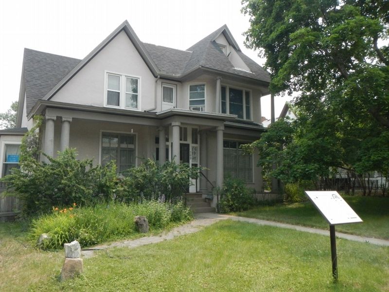
The Lyman-Neel Residence and its many occupants reflect the ever-changing character of the North Rodney Street neighborhood. Soon after Helena’s first county courthouse opened in 1867, merchants and professionals established Helena’s first . . . — — Map (db m188375) HM
Wilson Butts followed the stampede to Last Chance Gulch in 1864, staked his claim here, and built a serviceable one-room cabin. The following spring his brother Jonas arrived with a wife and three young daughters. Jonas added a front room and porch . . . — — Map (db m187372) HM
Former Montana First Lady and member of the Oro Fino Chapter Daughters of the American Revolution (DAR), Grace Vance Erickson spearheaded efforts to preserve this historic cabin. In 1938, Grace rallied DAR members, including chapter officers . . . — — Map (db m187315) HM
Small dwellings along this stretch of West Main Street housed miners and other boarders from the mid-1860s. The first plat of the Helena townsite, drawn in 1868, designated this former mining claim Block Number 1. Scottish immigrant Samuel Dempster . . . — — Map (db m187483) HM
Benjamin H. and Lydia Mears Tatem came west as newlyweds in 1869. They settled in Helena where Tatem managed the Unionville mining claims of Philadelphia investors and operated Helena Iron Works. Tatem profited from his interest in the Bald Butte . . . — — Map (db m187677) HM
In the spring of 1864, John S. Cowan of Georgia, D.J. Miller of Alabama, John Crabb of Iowa, and Reginald (Bob) Stanley of Nuneaton, England, set out from Alder Creek to prospect along the Little Blackfoot River. They had no luck and moved on, . . . — — Map (db m187411) HM
In 1864 four miners passed through this valley on their way back from an unsuccessful prospecting trip. Discouraged they decided to take one "last chance", filling their pans a few hundred yards south of here they struck pay dirt. Another boom town . . . — — Map (db m186777) HM
Helena owes its existence to gold-bearing quartz lodes in the hills south of town. The gold washed out of the hills into Last Chance Gulch where the "Four Georgians" discovered it in 1864. The fabulously rich strike drew hundreds of men and women to . . . — — Map (db m188671) HM
"Range life in 1900 was a grueling occupation and especially so in in the Alice
Creek area where early snows and long winters made for a very short summer
work period. When Alberta [Patterson] was twenty-one months old her
mother told of . . . — — Map (db m220035) HM
Marysville owes its existence to the nearby Drumlummon Mine developed by a
determined miner named Tommy Cruse. The British-owned Montana Mining Company
acquired the mine in 1883. Expansion of Drumlummon operations, including a large
ore . . . — — Map (db m155021) HM
In 1870 the mining town of Marysville was established and named for the first pioneer woman here, Mary Ralston, by Thomas Cruse, owner of the famous Drum Lummon Mine.
By 1900, the Marysville Mining District was reported to be the richest gold . . . — — Map (db m154440) HM
About 15,000 years ago, this area was covered by huge glaciers which formed unique geological formations throughout the valley called drumlins or hills composed of glacial till deposited beneath the glaciers.
Ice periodically dammed up the . . . — — Map (db m113518) HM
The Ruby River was called the Passamari by the Shoshoni Indians and the Stinking Water by the miners in the early 1860's.
Later, it was mistakenly renamed the Ruby, although the gems found along its length were actually garnets.
The . . . — — Map (db m116998) HM
Pete Daly built a log roadhouse at this site in 1863. Unlike most roadhouses of the time, which provided meals, companionship and a place to stay for weary travelers, Daly's was allegedly a hangout for Montana's most notorious criminal gang – the . . . — — Map (db m116999) HM
This small community of Sheridan is located approximately 55 miles south of Butte. Our population is 700 within the town proper, and approximately another 700 in the adjacent Ruby Valley rural area. When those who had come to Virginia City in the . . . — — Map (db m141494) HM
William O’Brien arrived in the gold-mining and ranching town of Sheridan, Montana, in 1881 and began selling liquor from a small sixteen-by-twenty-foot building. He was one of the town’s three suppliers of “wet groceries” (liquor), the quality of . . . — — Map (db m209428) HM
Fairweather and Party Discovered World’s Richest Placer Ground May 26, 1863
Most Important Center of Notorious Road Agent Activities 1863-1864
Center of Montana’s Famous Vigilante Organization 1863-1864
Home of Montana’s First Newspaper, . . . — — Map (db m128434) HM
Alder Gulch at peak population numbered ten thousand souls and the colorful mining camps that enjoyed the limelight were so numerous that contemporaries named it the Fourteen-mile City.
Adobetown was one of the many settlements that lined the . . . — — Map (db m117000) HM
Between 1870 and 1880, Virginia City's African American population was small compared to other minorities such as the Chinese. African American freighter Jack "Jarret" Taylor was in town as early as 1866, Sarah Bickford arrived in January 1871, and . . . — — Map (db m208756) HM
Martin and Anna Lyon came to Virginia City by covered wagon in 1864 and settled into this small dwelling. Martin, a successful tailor, was on his way home in January of 1865 when thieves attacked and fatally struck him over the head. A blizzard . . . — — Map (db m206467) HM
Dr. Levinus Daems built or purchased the home on the right (West) soon after his arrival in Virginia City in 1863. Born in Belgium, Levinus Daems studied medicine and pharmacy at the University of Paris. While in Paris, he likely met his future . . . — — Map (db m117102) HM
Two small houses shared this choice corner location in 1866, but after 1875, photographs reveal the unmistakable steeply pitched roof and central gable of this splendid Gothic Revival style residence.
Expansion and remodeling during the 1890s . . . — — Map (db m117044) HM
Charles Argalis Bovey ("Charlie") was born May 1, 1907, in Minneapolis, Minnesota into the comfort and social status provided by his father's position as President to the company which would become General Mills. Charlie, however, would find his . . . — — Map (db m208659) HM
The history of these two false-fronted cabins, joined by the 1890s, is interwoven with Virginia City’s African-American pioneers. The two separate, 1860s log cabins served both residential and commercial purposes. Minerva Coggswell acquired this . . . — — Map (db m208760) HM
This early home, built circa 1868 by C. E. Hill, was reputedly the site of Virginia City’s first Chinese wedding. The two-story section was originally finished in vertical siding, the eaves were trimmed in fancy latticework, and a small porch . . . — — Map (db m206343) HM
During Virginia City’s mid-1860s boom, residences and businesses crowded along Cover Street. Most commercial buildings were gone by the mid-1880s and the neighborhood became primarily residential. Irish immigrant Phillip Conrey, a rancher and . . . — — Map (db m206464) HM
Brothers John A. and Edward Creighton came west scouting the first transcontinental telegraph lines from Omaha, Nebraska, to the coast.
Temporarily settling in Virginia City, Edward hired Thompson and Griffith to construct this building, the . . . — — Map (db m117047) HM
Though simple by today’s standards, the Daems house exemplifies an upper-middle-class, early-1860s Virginia City dwelling. Dr. Levinus Daems and his wife Marie Daems, a nurse, may have been the first residents of the house. Born in Belgium and . . . — — Map (db m206284) HM
Light timber framing with board-and-batten walls characterizes this early home original to the Nevada City townsite. Inside, the original, well-preserved, muslin-covered walls are a rare example of a frontier decorating technique. The cabin’s . . . — — Map (db m117035) HM
J. A. Nelson built Leviathan Hall in 1863 with a "special view to the development of muscular talent." Torn down just five years later in 1868, the hall dominated Wallace Street with its impressive 28 feet wide and 100 feet long footprint.
. . . — — Map (db m117055) HM
Construction layers of this original homestead tell much of Nevada City’s ‘boom and bust’ history. In 1864, miner Frank Finney and his bride, Mary, moved into a cabin on this property that had been constructed the previous year. The cabin forms the . . . — — Map (db m49567) HM
The Frisch/Ferguson cabin escaped collapse twice and survives as an excellent example of a one-room log dwelling meant to provide short term, basic shelter for prospectors. The cabin’s early history is unknown, but by 1874, miner Fred Frisch and his . . . — — Map (db m206356) HM
Alder Gulch, located between Virginia City and Alder, is one of the most significant placer mining districts in the U.S., having produced over 2.5 million troy ounces of gold between 1863, and 1889. In total, miners recovered over $40 billion . . . — — Map (db m117023) HM
In the mid-1860s stores, hotels, and businesses lined both sides of Jackson Street near Idaho. The road was bustling with pedestrians and noisy teams of horses and wagons traveling on the toll road that led South to Summit. The Tootle, Leach & Co. . . . — — Map (db m209178) HM
When in the hills, prospectors often constructed temporary shelters called wikiups. Minters stood poles in a half circle and bound smaller ends together at the top with a cord. Evergreen boughs were planted against this conical frame work forming a . . . — — Map (db m208999) HM
The gold rush to Alder Creek in 1863 spurred settlement of the Madison Valley, and among the first families to settle here were the Jeffers, the Switzers (whose home is preserved here in Nevada City) and the Careys. Irish-born Nick Carey walked to . . . — — Map (db m49565) HM
Nine booming gold camps sprawled along remote Alder Gulch in 1863. Nevada City and Virginia City were the largest. In December, 1863, Nevada City’s main street was the scene of the miner’s court and hanging of George Ives. This event was the . . . — — Map (db m49563) HM
This narrow frame building may be one of Virginia City’s earliest structures, dating to the summer of 1863 when buildings like this were rented for up to $175 during the initial gold rush. Its odd-sized door appears to have been locally handmade. . . . — — Map (db m49412) HM
Many people have called Virginia City their home and many thousands of others have had the pleasure of visiting this unique town. This would hardly be a place worth visiting, were it not for the tireless efforts of a man unpretentiously known . . . — — Map (db m208661) HM
The Simon (Sim) Ferguson Cabin is a Virginia City prospector's cabin dating back to the 1870s. Likely constructed from logs salvaged from another building in the area, the cabin underwent several modifications during its history, Historic evidence . . . — — Map (db m206355) HM
The home on the left (East) belonged to John L. Corbett, a civil engineer who drafted the original plat of Virginia City in 1868.
Records indicate that Corbett owned the home only briefly in 1875-76. The Corbett side of the dwelling is . . . — — Map (db m117104) HM
The small-scale simplicity of Susie Marr’s house belies the owner’s rich life. Marr emigrated from Scotland in 1870. In Virginia City, she managed household affairs for banker, William Morris, his wife, and their six children. In turn, Morris took . . . — — Map (db m209172) HM
A steeply pitched roof and windows with pointed arches reveal Gothic Revival style influence in this finely-crafted 1884 residence, built by George Thexton. The style, often adapted to the frontier in wood, is here expressed in stone as was the norm . . . — — Map (db m206266) HM
Prospectors found placer gold along a streambed choked with alder trees in May, 1863.
Thousands came from every corner of the world to try their luck in the placer mines and, perhaps, to garner a piece of the far-famed treasure.
A brief but . . . — — Map (db m117029) HM
To truly appreciate the scale of the Boveys' accomplishment in Virginia City, it's important to understand what they found when they first visited in the mid-1940s.
After more than 80 years, Alder Gulch's legendary gold deposits were . . . — — Map (db m208660) HM
The spectacular gold discovery in Alder Gulch on May 26, 1863, led to the rapid growth of this colorful and legendary gold camp town. Thousands of fortune-seekers rushed to the area, and by 1864 the Virginia City area boasted 30,000 residents. Rough . . . — — Map (db m49382) HM
In 1910, the three Brockway brothers filed on adjoining homesteads along the fertile Redwater River near here. A small trading center on brother James's homestead provided supplies and other services to their neighbors. by 1913, the settlement's . . . — — Map (db m143263) HM
Major Seth Mabry, a former Confederate Army officer, came to the Redwater Valley about 1883, driving a heard of longhorns from Texas. President of the Mabry Cattle Co., he branded with a plain circle iron. From the brand, the operator became known . . . — — Map (db m143261) HM
The discovery of gold, silver, lead and copper in this area brought about the establishment of Camp Baker in 1869 to protect settlers from Indian raids.
Named Fort Logan in 1877, the post was abandoned in 1880.
The block house which . . . — — Map (db m127844) HM
The mountains to the west are the Big Belts, and those to the east the Castle Mountains. The gulches draining the west slope of the Big Belts were famous in the ‘60s and ‘70s for their gold placer diggings. Montana Bar in Confederate Gulch was . . . — — Map (db m127842) HM
The local hot springs had been a business enterprise for almost a decade when in 1880 brothers William H. and Robert N. Sutherlin moved their newspaper, the Rocky Mountain Husbandman, from the waning gold camp at Diamond City to the promising town . . . — — Map (db m188858) HM
"Our work ... from the 16th of August to the 4th of December, 1859 consisted of cutting through this densely timbered section of one hundred miles, building small bridge were required, and grading thousands of places.... the work was heavy, and . . . — — Map (db m123025) HM
Travelers along the Mullan Road and prosectors lured by the 1869 discovery of gold on Cedar Creek opened the way for settlement of this area. After the placer gold played out and other mining camps became ghost towns, the town of Superior continued . . . — — Map (db m123029) HM
Who was Frank Hamilton? No one really knows. Simple grave markers pay a humble tribute to the five miners buried at the Sand Park Cemetery between 1898 and 1914. Little more is known than their names and year of death. Most of the other . . . — — Map (db m71503) HM
Once, the Garnet Mountains echoed with the blasts of dynamite, the clatter of hooves on steep, narrow roads, and the shouts of men out to find fortune.
Once, miners swapped stories in the saloons of Beartown, Top O'Deep and Reynolds City — . . . — — Map (db m130332) HM
White Sulphur Springs businessman Harvey Spencer bought this newly constructed Queen Anne “Free Classic” style boardinghouse in 1902. The cross-gable roof and side bay window represent the Queen Anne form, while the pedimented porch entry and eave . . . — — Map (db m212348) HM
Born of the 1883 arrival of the Northern Pacific Railroad, the Northside grew with the railroad’s early twentieth- century expansion. Simple housing predominated in the working-class neighborhood, which contained few brick homes. This circa 1904 . . . — — Map (db m144526) HM
Despite Civil War turmoil, progress was bravely pushing Westward, leading into the Gilded Age of substantial growth in population and wealth.
Cantonment Wright and Hell Gate
In November 1861, John Mullan established Cantonment . . . — — Map (db m123096) HM
The narrow river canyons upstream from here have a long and bloody past.
As the Salish, Nez Perce and other western mountain Indian tribes passed through these canyons enroute to buffalo hunting grounds east of the Rocky Mountains, they were . . . — — Map (db m123334) HM
A steeply pitched roof and a Gothic-arched attic window embellish this Folk Gothic style farmhouse, built by Francis L. Worden in 1874. Worden left New York in 1852 for adventure in California, traveled to Panama, clerked for Washington’s . . . — — Map (db m144758) HM
(Three panels, presented left to right, form the marker.)
Many Cultures Forge Strong Communities
Welcome to Bonner and nearby communities, each built on the grit and dreams of self-made men and women. It you had walked into . . . — — Map (db m123099) HM
Northern Ohio University graduate Edwin S. Newton came to Missoula in 1890 where up-and-coming architect A.J. Gibson had promised him work. Under Gibson's tutelage, Newton proved an able carpenter and builder. He eventually opened his own . . . — — Map (db m144707) HM
Generations of Northsiders have grown up in the shadow of the railyards since the Northern Pacific Railroad’s arrival in 1883 transformed Missoula into a modern city. Accepting land as an enticement from A. J. Urlin and other leading businessmen, . . . — — Map (db m144560) HM
Rattlesnake Creek enters the Clark Fork River across from this point, completing the journey from its headwaters high in the Rattlesnake National Wilderness Area. Missoula’s first building was a two-room log cabin constructed by William T. Hamilton . . . — — Map (db m130323) HM
Jesuits arrived in the Missoula Valley in 1841 en route to the Bitterroot, where they established the first Catholic mission in the Rocky Mountains. In 1873, they opened a chapel in Missoula, building the first St. Francis Xavier Church in 1881. . . . — — Map (db m144462) HM
Julia and Aaron Conner homesteaded in the Bitterroot Valley in 1882 where they prospered and raised six children. Aaron was elected judge at Darby in 1886 and served as Speaker of the House in the Montana legislature in 1900 and 1903. After Aaron . . . — — Map (db m219044) HM
Prospectors discovered rich mineral deposits in the Beartooth Mountains near here in 1874. Christened the New World Mining District, the area included claims with colorful names like Miner’s Delight, Hidden Treasure, Southern Spy and Silver King. . . . — — Map (db m45240) HM
The Absaroka - Beartooth Wilderness, which lies to the east, contains one of the largest single expanses of land above 10,000 feet in elevation in the United States. The U.S. Forest Service set aside portions of the region as primitive areas in . . . — — Map (db m123116) HM
Named for fur trapper, Johnson Gardner, Gardiner has had a rough and tumble history to match. The town was established when one of the earliest entrepreneurs in Yellowstone, James C. McCartney, was invited by the park superintendent to remove . . . — — Map (db m227632) HM
From 1900 to 1910, the Northern Pacific Railroad’s good fortunes overflowed into Livingston. Expansion of railroad services brought an influx of blue-collar workers and their families who located on the convenient Eastside, near the railroad shops . . . — — Map (db m191724) HM
Livingston was inextricably tied to the railroad, but its business community also influenced the town’s character. After 1900, professionals and entrepreneurs built new homes on the Westside when the expansion of downtown encroached on the previous . . . — — Map (db m191796) HM
This river was named by Captain William Clark of the Lewis and Clark Expedition in honor of John Shields, a member of the party. Captain Clark and his men, guided by Sacajawea, the Shoshone woman, camped at the mouth of the river July 15, 1806, . . . — — Map (db m128299) HM
Dupuyer Creek was called Osaks itukai (Back fat) by the Blackfeet. It refers to a choice cut of buffalo meat the Indians relished. French Canadian fur trappers translated the name to "Depouille," the French word for hide. Over time, the name was . . . — — Map (db m220216) HM
1900Broadus post office established, named after the Broaddus family. 1919Powder River County formed. Frank Kelsey, Moorhead rancher and Custer County state senator, introduced the bill drawn up by A.W. Heidel, Helena . . . — — Map (db m203084) HM
From its source in central Wyoming to its union with the Yellowstone River, the Powder River is 250 miles long, "a mile wide and an inch deep; to thick to drink and to thin to plow." During World War I, Montana's 91st Division gained national . . . — — Map (db m189210) HM
For cowboys on the open range, chuckwagons like this one were the closest they got to home for weeks at a time. They gathered here for food, companionship, and sleep.
The cook served up coffee, beans, rice, sourdough breads and occasional . . . — — Map (db m210250) HM
Kohr's grandson, Conrad Kohrs Warren, spent many summers with his grandparents, He gained a passion for ranching from watching and helping his great-uncle, John Bielenberg, on the ranch. In 1932 he took over ranch management.
Like his . . . — — Map (db m212230) HM
Gold was discovered near Deer Lodge in 1862. Subsequent discoveries in Bannack and Virginia City prompted a gold rush that attracted men and women of both good and bad character. Thievery, lawlessness, and murder prevailed until vigilante groups . . . — — Map (db m127789) HM
John Francis Grant
Grant chose this ranch site for its rich grasslands, abundance of water, and the sheltered valley. He completed this house in 1862 as a trading post and family home. He first traded cattle with emigrants on the . . . — — Map (db m210236) HM
North American cowboys can trace their roots back to the Spanish conquistadors, who brought cattle and horses to the New World. Mexican cowboys, known as vaqueros, developed methods on horsemanship and working cattle in the rugged terrain that is . . . — — Map (db m212229) HM
During the last ice age about 18,000 years ago, an enormous glacier pushed down from British Columbia and blocked the Clark Fork River in northern Idaho. The glacier functioned as an ice dam creating the largest glacial lake known to have existed, . . . — — Map (db m212233) HM
Three panels make-up this marker.
(Panel 1:)
Ovando Town History
This area around Ovando was visited for centuries by various Indian tribes who followed "Cokalahiskit," the River of the Trail of the Buffalo. Now called the Big . . . — — Map (db m144062) HM
Hamilton was born of the Anaconda Company’s voracious appetite for lumber, nurtured on the Bitterroot apple boom, and sustained by medical research. Copper King Marcus Daly—whose Big Mill cut millions of board feet annually to feed his mines . . . — — Map (db m123553) HM
Calvin and Magdalene Cook came to Montana from Kansas in 1880 and settled near Stevensville. Like many early settlers, the Cooks’ intent was to farm. After more than a decade of farming, however, business opportunities in Stevensville beckoned and . . . — — Map (db m123449) HM
1 • Stanley Fur trappers from the Hudson’s Bay Company were the first to discover Stanley Basin during 1824. Stanley was named for Captain John Stanley, a Civil War veteran who brought 23 prospectors into the basin searching for gold. . . . — — Map (db m144160) HM
The Burgess Garage was constructed circa 1913 and is the oldest building standing in Lambert. That year the Northwest Improvement Company, a subsidiary of the Northern Pacific Railroad, platted the new townsite. Business at the garage (then called . . . — — Map (db m143241) HM
The second in a series of Centennial Acres was donated in 1986 by Montana's First Lady, Jean Schwinden, and her brother Julius Christianson. Located where their immigrant parents, Nels and Amanda Christianson, settled in 1913, the site is . . . — — Map (db m202997) HM
Northern Pacific conductor Frank Runyan and his wife, Nellie, built this one-story bungalow in 1914. County jailor Dick Wright and his wife, Edith, lived here from 1919 to 1923. A. J. and Ina Freeman owned the home in 1940. A. J. was justice of the . . . — — Map (db m164850) HM
Founded for the railroad, Forsyth’s residential neighborhoods were platted in 1882 but much of the land lay undeveloped until the 1900s. Forsyth’s first-generation homes were simple dwellings rapidly constructed of wood or log to serve the immediate . . . — — Map (db m164627) HM
Hiram Marcyes was born September 11, 1844 in Newberg, Maine. He served in the Civil War as a bugler in the Fourth Minnesota Volunteer Infantry Company with the the Union army. His service took him in battles from Vicksburg to Sherman's March to the . . . — — Map (db m188746) HM
The history of Forsyth depends heavily on two men - Thomas Alexander and Hiram Marcyes - very different individuals yet both dedicated to creative and aggressive growth. Thomas Alexander began as a pioneer sheep, cattle and horse rancher and . . . — — Map (db m165231) HM
Founded in 1908, Ingomar became a hub of commerce when the Milwaukee Road Railroad completed its line across Montana. The community had no source of water and relied on the railroad to provide 22,000 gallon water tank cars each week for the town . . . — — Map (db m189089) HM
Founded in 1908, Ingomar became a hub of commerce when the Milwaukee Road Railroad completed its line across Montana. The community had no source of water and relied on the railroad to provide 22,000 gallon water tank cars each week for the town . . . — — Map (db m189095) HM
David Thompson was the first Euro-American to record his travels along this stretch of the river. Early in 1809 he came through searching for an ideal site to establish a fur trading post. Later that fall he built the “Saleesh House” . . . — — Map (db m45195) HM
Wild Horse Plains is nestled in a circular valley at an elevation of 2,450 ft., drained by the Clark Fork River. Between 70,000 and 130,000 years ago the Bull Lake ice age glaciers dammed the Clark Fork River Valley creating Glacial Lake Missoula. . . . — — Map (db m219335) HM
On Christmas Day of 1914 the Sanders County Ledger reported that “…no town in western Montana … has advanced with the same rapid strides as Thompson Falls.” Indeed, the town possessed all the modern trappings: new streetlights illuminated the . . . — — Map (db m219643) HM
In November 1809, famed British North West Company agent and explorer David Thompson built a trading post about five miles east of here near the mouth of the Thompson River.
Strategically located on a well-worn aboriginal trail, Saleesh House was . . . — — Map (db m112921) HM
A row of small one-story dwellings occupied the west half of this block in 1884. By 1900, the James McBride family was in residence. Like most of his immediate neighbors, James was a miner born in Ireland. He and his wife Margaret—a native of Kerry, . . . — — Map (db m184903) HM