After filtering for Arizona, 218 entries match your criteria. The first 100 are listed. ⊳
Native Americans Topic
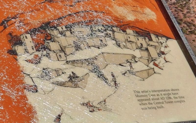
Marker detail: Mummy Cave, circa 1286
| 1 ► Arizona, Apache County, Chinle — House Under Rock — |
| Near Mummy Cave Overlook Road, 1.5 miles east of North Rim Highway (Indian Route 64). | |||
| 2 ► Arizona, Apache County, Chinle — Sliding House Ruins — |
| Near Sliding House Overlook Road, 1.6 miles north of South Rim Highway (Indian Route 7). | |||
| 3 ► Arizona, Apache County, Chinle — The Place Where Two Fell Off — |
| Near Mummy Cave Overlook Road, 1.5 miles east of North Rim Highway (Indian Route 64). | |||
| 4 ► Arizona, Apache County, Lupton — One Days Ride to Zuni — |
| Near Interstate 40 at milepost 359. | |||
| 5 ► Arizona, Apache County, Window Rock — About the Navajo Code Talkers — |
| Near BIA Route 100 (Route 100) 0.8 miles east of Route 12 (Arizona Route 264) when traveling north. | |||
| 6 ► Arizona, Apache County, Window Rock — In Remembrance of Our Warriors / Navajo Warrior Memorial — |
| Near Parking Lot BIA 100 MP 0 (Route 100 Connector Road) 0.8 miles east of Route 12 N (Arizona Highway 263). | |||
| 7 ► Arizona, Cochise County, Benson — Four miles southeast at Council Rocks — Apache peace treaty with Cochise was ratified in 1872 — |
| Near Interstate 10 at milepost 320. | |||
| 8 ► Arizona, Cochise County, Bowie — Apache Spring — |
| Near Fort Bowie Trail, 1.2 miles south of Apache Pass Road. | |||
| 9 ► Arizona, Cochise County, Bowie — Bascom-Cochise Meeting Site — |
| Near Fort Bowie Trail, 0.6 miles Apache Pass Road. | |||
| 10 ► Arizona, Cochise County, Bowie — Centennial of Chiricahua Apache/U.S. Cessation of Hostilities 1886 — |
| On West Fifth Street, on the left when traveling west. | |||
| 11 ► Arizona, Cochise County, Bowie — First Fort Bowie — |
| On Apache Pass Road. | |||
| 12 ► Arizona, Cochise County, Bowie — Fort Bowie — National Historic Site — |
| On South Apache Pass Road at Interstate 10 on South Apache Pass Road. | |||
| 13 ► Arizona, Cochise County, Bowie — The Bascom Affair — |
| Near Apache Pass Road. | |||
| 14 ► Arizona, Cochise County, Bowie — The Chiricahua Apache Indian Agency — |
| Near Fort Bowie Trail, 1 mile south of Apache Pass Road. | |||
| 15 ► Arizona, Cochise County, Cochise — Sulphur Springs — |
| On Birch Road, 3.1 miles east of U.S. 191, on the right when traveling east. | |||
| 16 ► Arizona, Cochise County, Dragoon — Dragoon Springs Stage Stop — Land of Legends — Coronado National Forest — |
| On North Old Ranch Road. | |||
| 17 ► Arizona, Cochise County, Elfrida — Camp Rucker Timeline — |
| Near North Tex Canyon Road near East Rucker Canyon Road. | |||
| 18 ► Arizona, Cochise County, Elfrida — Chief Cochise — |
| Near Ironwood Road. | |||
| 19 ► Arizona, Cochise County, San Simon — Geronimo Surrender Monument — |
| On Arizona Route 80 at milepost 406 near Skeleton Canyon Road, on the right when traveling east. | |||
| 20 ► Arizona, Cochise County, Sierra Vista — Apache Scout Memorial — |
| On Grierson Avenue north of Hungerford Avenue, on the right when traveling south. | |||
| 21 ► Arizona, Cochise County, Willcox — The Chiricahua Apache — Chiricahua National Monument — |
| On East Rhyolite Creek Road. | |||
| 22 ► Arizona, Coconino County, Flagstaff — A Gathering Place — |
| On Loop Road, on the left when traveling north. | |||
| 23 ► Arizona, Coconino County, Flagstaff — A Legacy of the Past — |
| On Loop Road, on the right when traveling north. | |||
| 24 ► Arizona, Coconino County, Flagstaff — A Village/Abandonment — |
| On Loop Road, on the left when traveling north. | |||
| 25 ► Arizona, Coconino County, Flagstaff — Ancient Landscapes — |
| On Loop Road, on the right when traveling north. | |||
| 26 ► Arizona, Coconino County, Flagstaff — Box Canyon Ruins — |
| On Loop Road, on the right when traveling north. | |||
| 27 ► Arizona, Coconino County, Flagstaff — Daily Life — |
| On Loop Road, on the right when traveling north. | |||
| 28 ► Arizona, Coconino County, Flagstaff — Dry Land Farming — |
| On Loop Road, on the right when traveling north. | |||
| 29 ► Arizona, Coconino County, Flagstaff — Sunset Crater Volcano — |
| On Loop Road, on the right when traveling north. | |||
| 30 ► Arizona, Coconino County, Flagstaff — The Citadel / Natural Features — |
| On Loop Road, on the left when traveling north. | |||
| 31 ► Arizona, Coconino County, Flagstaff — The Navajo Code Talkers — |
| On South Knoles Drive, on the right when traveling south. | |||
| 32 ► Arizona, Coconino County, Flagstaff — Wukoki — |
| On Loop Road. | |||
| 33 ► Arizona, Coconino County, Grand Canyon National Park — Bright Angel Trail — |
| 34 ► Arizona, Coconino County, Grand Canyon National Park — El Tovar Hotel — Begun 1903, Completed 1905 — |
| 35 ► Arizona, Coconino County, Grand Canyon National Park — Hopi House — Mary Elizabeth Jane Colter |
| Reported missing. | |||
| 36 ► Arizona, Coconino County, Grand Canyon National Park — Hopi House — Constructed in 1905 — |
| 37 ► Arizona, Coconino County, Grand Canyon National Park — Kaibab Trail Suspension Bridge — National Historic Civil Engineering Landmark — |
| On Rim Trail north of Yavapai Point, on the right when traveling west. | |||
| 38 ► Arizona, Coconino County, Grand Canyon National Park — Tusayan Museum and Ruin — |
| 39 ► Arizona, Coconino County, Grand Canyon National Park — Tusayan Ruin Trail — |
| 40 ► Arizona, Coconino County, Grand Canyon Village — Ancient Illusion — Grand Canyon — |
| Near Desert View Drive (Arizona Route 64) 21.5 miles east of South Entrance Road. | |||
| 41 ► Arizona, Coconino County, Grand Canyon Village — Hopi House — |
| On El Tovar Road, 0.1 miles north of Village Loop Drive, on the right when traveling west. | |||
| 42 ► Arizona, Coconino County, Grand Canyon Village — Spanish Discovery — |
| Near Desert View Drive (Arizona Route 64) 14.6 miles east of South Entrance Road, on the left when traveling east. | |||
| 43 ► Arizona, Coconino County, Marble Canyon — John Deering — (Bih Bitoodnii Nez) — |
| Near U.S. 89A at milepost 537, on the right when traveling west. | |||
| 44 ► Arizona, Coconino County, Marble Canyon — Lewis Nez — |
| Near U.S. 89A at milepost 537, on the right when traveling west. | |||
| 45 ► Arizona, Coconino County, North Rim — Summer Home — Grand Canyon National Park — |
| Near Grand Canyon Highway (Arizona Route 67) 43 miles south of U.S. 89A. | |||
| 46 ► Arizona, Coconino County, Sedona — The Sinagua — Historic Sedona — |
| Near State Highway 89A. | |||
| 47 ► Arizona, Coconino County, Sunset Crater Volcano National Monument — "The Peaks" — |
| 48 ► Arizona, Coconino County, Sunset Crater Volcano National Monument — Changes to Come — |
| 49 ► Arizona, Coconino County, Sunset Crater Volcano National Monument — Geological Infant — |
| 50 ► Arizona, Coconino County, Sunset Crater Volcano National Monument — The Power to Symbolize — |
| 51 ► Arizona, Coconino County, Tuba City — Arizona's First Woolen Mill |
| On Arizona Route 264 at milepost 323, on the right when traveling east. Reported missing. | |||
| 52 ► Arizona, Coconino County, Walnut Canyon National Monument — A Community Sharing the Land — |
| 53 ► Arizona, Coconino County, Walnut Canyon National Monument — A Complex Community — |
| 54 ► Arizona, Coconino County, Walnut Canyon National Monument — A Days Work — |
| 55 ► Arizona, Coconino County, Walnut Canyon National Monument — A Ribbon of Life — |
| 56 ► Arizona, Coconino County, Walnut Canyon National Monument — A Time of Change — |
| 57 ► Arizona, Coconino County, Walnut Canyon National Monument — An Efficient Design — |
| 58 ► Arizona, Coconino County, Walnut Canyon National Monument — Cliff Homes and Canyon Life — |
| 59 ► Arizona, Coconino County, Walnut Canyon National Monument — Departure — |
| 60 ► Arizona, Coconino County, Walnut Canyon National Monument — From Ocean to Alcove — |
| 61 ► Arizona, Coconino County, Walnut Canyon National Monument — Migration is not abandonment. — |
| 62 ► Arizona, Coconino County, Walnut Canyon National Monument — Problem Solving — |
| 63 ► Arizona, Coconino County, Walnut Canyon National Monument — Room Functions — |
| 64 ► Arizona, Coconino County, Walnut Canyon National Monument — Tension and Harmony — |
| 65 ► Arizona, Coconino County, Walnut Canyon National Monument — The Perfect Shelter — |
| 66 ► Arizona, Coconino County, Walnut Canyon National Monument — The Quest for Water — |
| 67 ► Arizona, Coconino County, Walnut Canyon National Monument — What Happened Here? — |
| 68 ► Arizona, Coconino County, Williams — Bill Williams Mountain — Elevation 9,264 Ft — |
| On West Bill Williams Avenue/West Route 66, on the left when traveling east. | |||
| 69 ► Arizona, Coconino County, Wupatki National Monument — Community — |
| 70 ► Arizona, Coconino County, Wupatki National Monument — Nalakihu — |
| 71 ► Arizona, Coconino County, Wupatki National Monument — The Ballcourt — A Mexican Idea at Wupatki — |
| 72 ► Arizona, Coconino County, Wupatki National Monument — The Blowhole — |
| 73 ► Arizona, Coconino County, Wupatki National Monument — Where Were The Fields? — |
| 74 ► Arizona, Gila County, Globe — Hon. George W. P. Hunt — 1859 – 1934 — |
| On North Broad Street, on the right when traveling north. | |||
| 75 ► Arizona, Gila County, Payson — Shoofly Village Ruin — |
| Near Houston Mesa Road, 3 miles east of Arizona Route 87. | |||
| 76 ► Arizona, Graham County, Fort Thomas — Geronimo — |
| On U.S. 70 at milepost 302, on the left when traveling east. | |||
| 77 ► Arizona, Graham County, Safford — In Memory of Lorenzo and Seth Wright — |
| On U.S. 70 at milepost 356,, 16 miles east of Town of Safford, on the left when traveling east. | |||
| 78 ► Arizona, Greenlee County, Duncan — Apache Grove — |
| On Arizona Route 75 at milepost 392, on the left when traveling north. | |||
| 79 ► Arizona, La Paz County, Ehrenberg — In Memory of Hualapai Ancestors — Yu’ Nyihay Jamj Vo:jo — La Paz Trail of Tears - April 21, 1874 – April 21, 1875 — |
| On Poston Road/Mohave Drive (Arizona Route 1 at milepost 3), 6 miles north of Interstate 10, on the left when traveling north. | |||
| 80 ► Arizona, La Paz County, Parker — Poston Memorial Monument — |
| On Mohave Road, 11.7 miles south of Arizona Route 95, on the right when traveling north. | |||
| 81 ► Arizona, Maricopa County, Apache Junction — Alchesay — |
| On Arizona Route 88 at milepost 241, on the left when traveling east. | |||
| 82 ► Arizona, Maricopa County, Fort McDowell — Grave of Dr. Carlos Montezuma — (Wassaja) — 1855-1923 — |
| On Beeline Highway (Arizona Route 87 at milepost 190) near North Fort McDowell Road, on the right when traveling north. | |||
| 83 ► Arizona, Maricopa County, Mesa — Mesa Grande — |
| On West 10th Street at North Cherry, on the right when traveling west on West 10th Street. | |||
| 84 ► Arizona, Maricopa County, Mesa — Prehistoric Irrigation in the Salt River Valley — |
| Near North Horne Avenue, 0.4 miles south of East McKellips Road. | |||
| 85 ► Arizona, Maricopa County, Phoenix, Central City — Father Albert Braun O.F.M. — Born September 5, 1889 Died March 6, 1983 — |
| Near West Adams Street. | |||
| 86 ► Arizona, Maricopa County, Phoenix, Central City — Navajo Code Talkers — United States Marine Corps - World War II — |
| Near Adams Street. | |||
| 87 ► Arizona, Maricopa County, Phoenix, Crestwood — S. (Frenchy) Sawyer — |
| Near East Washington Street, 0.1 miles east of South 24th Street. | |||
| 88 ► Arizona, Maricopa County, Phoenix, Midtown — In Memory of the Students of this School who Enlisted in the Army and Navy during the World War — |
| Near North 3rd Street, 0.1 miles north of East Indian School Road. | |||
| 89 ► Arizona, Maricopa County, Phoenix, Midtown — Tribute to Navajo Code Talkers — |
| On East Thomas Road (Old U.S. 60) at Central Avenue, on the left when traveling west on East Thomas Road. | |||
| 90 ► Arizona, Maricopa County, Phoenix, Midtown — United States Indian Vocational Training School — |
| On North 3rd Street near East Indian School Road. | |||
| 91 ► Arizona, Maricopa County, Scottsdale, Paradise Valley Village — Chief Washakie — Dave McGary — |
| Near East Lincoln Drive, 1 mile east of North Tatum Boulevard, on the left when traveling east. | |||
| 92 ► Arizona, Maricopa County, Sentinel — Oatman Massacre Site — |
| Near Oatman Road, 8.8 miles north of Agua Caliente Road. | |||
| 93 ► Arizona, Maricopa County, Sentinel — The Oatman Family — |
| Near Oatman Road, 10.7 miles north of Agua Caliente Road. | |||
| 94 ► Arizona, Maricopa County, Wickenburg — Wickenburg Massacre — |
| On U.S. 60 at milepost 106 at Flying E Ranch Road, on the right when traveling east on U.S. 60. | |||
| 95 ► Arizona, Mohave County, Bullhead City — Old Fort Mohave — |
| Near State Highway 68. | |||
| 96 ► Arizona, Mohave County, Dolan Springs — White Hills — Ghost Town of — |
| On U.S. 93 at White Hills Road, on the right when traveling north on U.S. 93. | |||
| 97 ► Arizona, Mohave County, Fredonia — A Good Drink of Water — Pipe Spring National Monument — |
| Near North Pipe Spring Road, 0.3 miles north of Arizona Route 389, on the left when traveling north. | |||
| 98 ► Arizona, Mohave County, Fredonia — At Home in the Desert — Pipe Spring National Monument — |
| Near North Pipe Spring Road, 0.3 miles north of Arizona Route 389, on the left when traveling north. | |||
| 99 ► Arizona, Mohave County, Fredonia — Boundaries and Fencing — Pipe Spring National Monument — |
| Near North Pipe Spring Road, 0.3 miles north of Arizona Route 389, on the left when traveling north. | |||
| 100 ► Arizona, Mohave County, Fredonia — Cut Off By The Grand Canyon — Pipe Spring National Monument — |
| Near North Pipe Spring Road, 0.3 miles north of Arizona Route 389, on the left when traveling north. | |||
218 entries matched your criteria. The first 100 are listed above. Next 100 ⊳