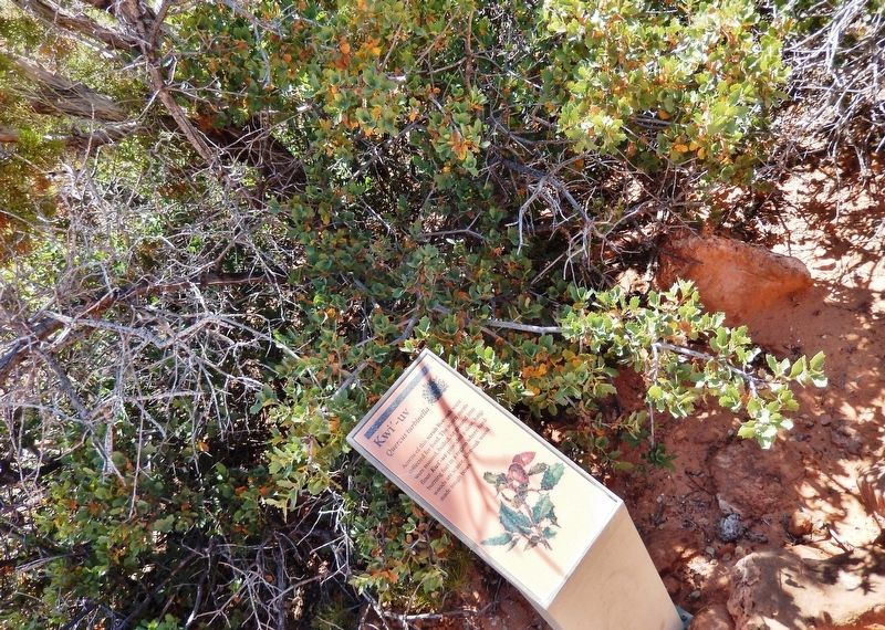
Acorns of this scrub live-oak were collected for food. The acorn meats were roasted, boiled, or ground into flour. Kwi’-uv provided a slow, long-burning fuel in a region where hardwoods are scarce. Live-oak wood made tough bows. — — Map (db m149470) HM
Paiute people used the dark green leaves of datura, crushed as a poultice, to treat sores and swelling. This traditional medicinal plant was chewed to reduce toothache pain, as well as induce visions. Datura is highly poisonous. Please do not touch. — — Map (db m149368) HM
Food, fuel, and fiber came from the yucca. Paiute people pounded the leaves to obtain fiber for rope, nets, baskets, jugs, mats, and sandals. Shampoo came from the roots. The fruit was roasted and then eaten, or made into a ball and dried for winter . . . — — Map (db m149401) HM
Pipe Spring National Monument is establishing a native vegetation plot, reminiscent of the grasslands of the Arizona Strip prior to the 1850s. Over-abundant shrubs (four-wing saltbush and sagebrush) were removed from the area, and native grasses and . . . — — Map (db m149366) HM
Two evergreens important to the Paiute people grow intermingled on this ridge top. Throughout the desert Southwest, at elevations from 4,500 to 7,500 feet above sea level, with more than 12 inches of rain a year, look for stands of pinyon and . . . — — Map (db m149397) HM
Many high places you see jutting out along the Vermilion Cliffs had to be climbed by this team of federal surveyors in winter 1872–73. Explorer John Wesley Powell often camped and resupplied at Pipe Spring. From here the survey team set up . . . — — Map (db m149400) HM
Paiute families watched rabbitbrush closely as summer ended. This blossom marked the time to move to high country to gather pinyon nuts, a favorite food. Portions of the root could be chewed like gum. — — Map (db m149402) HM
Baskets and cradleboards were made from the stems of the three-leaf sumac, but its tart berries bring back Paiute people's best memories. Also called lemonadeberry, the small fruits were pounded into a pulp, then squeezed. Mixed with water, the . . . — — Map (db m149399) HM
Paiute people still use Indian tea (or Mormon tea) as both a beverage and a medicine. An infusion of the gray-green spikelets can treat stomach aches, rheumatism, colds, and kidney problems. Tup' also serves as a blood tonic that improves . . . — — Map (db m149396) HM
1880 — Ten years ago the desert spaces… were covered with abundant grasses. Today hardly a blade of grass is to be found within 10 miles of [Pipe] spring… Even if there had been no drought… cattle would have… destroyed the grass by cropping . . . — — Map (db m149473) HM
In the fall, look for plum-sized purple fruit on these prickly pear cactus. These 'pears' are good eaten fresh. Paiute people compressed and dried the fruits into cakes for trade and winter storage. — — Map (db m149371) HM
This camp, established March 25, 1871 by Company F, 12th Infantry commanded by Capt. Thomas Bryne, was located at a spring used by Indians for centuries. It was named for Navy Lt. Edward F Beale who established a wagon road along the 35th parallel. . . . — — Map (db m29411) HM
In Memory of
Our Hualapai Ancestors
Who Fought Against Cultural Genocide
With Bravery and Foresight
They Sacrificed Their Lives
So The Hualapai People's
Survival May Continue
Today And Forever…
This location was a . . . — — Map (db m36013) HM
Olive Ann Fairchild, Indian captive and lecturer, daughter of Royse (Royce) and Mary Ann (Sperry) Oatman, was born in Illinois in September 1837 or 1839. In 1850 the family joined a wagon train bound for the part of the Colorado River now in . . . — — Map (db m188959) HM
These grounds belong in spirit and enthusiasm to Dallas Quasula Sr., a member of the Hualapai tribe. Dallas, a tribal councilman and elder, was also a highly regarded citizen of the county and graduate of Seligman High School. Dallas served . . . — — Map (db m119933) HM
This property was listed in the National Register of
Historic Places on November 21, 2003. The Historic
Peach Springs Trading Post, in downtown Peach Springs
circa 1932, was an important commercial enterprise for
Peach Springs citizens and . . . — — Map (db m58607) HM
These ruins represent the last surviving enlisted men's barracks, on the east end of Barracks Row. Much like Officers' Row defined the north side of the Parade Ground, Barracks Row made up the south side. This adobe barracks was one of two . . . — — Map (db m209362) HM
Throughout the military history of Fort Apache, enlisted men were housed with their units to the south of Officers' Row. The first company quarters, completed in February 1871, were 18 by 20 foot log squad huts built in rows running north and south . . . — — Map (db m36807) HM
The Boys' Dormitory was constructed in 1932. Located on the east end of the fort's Parade Ground, it is on the site of earlier military structures including a telegraph office. Sandstone was quarried for the building's construction from a site . . . — — Map (db m36875) HM
An 1891 fire, sparked by a defective chimney and fanned by high winds, destroyed five sets of wood frame officers' quarters that had been constructed in this area between 1883 and 1886.
Using sandstone quarried just east of the Fort, these two . . . — — Map (db m36779) HM
Built in 1889 to replace a smaller adobe structure, the Commissary Storehouse served as the Fort's food storage and distribution point until its closure in 1922. A solid building, the storehouse includes a stone cellar that extends three-fourth of . . . — — Map (db m36804) HM
This log cabin is the oldest surviving building at Fort Apache. The westernmost of a series of eight log cabins built in 1871 to form Officers' Row, this cabin was designated the Commanding Officer's Quarters. It was originally an 18 by 20 foot log . . . — — Map (db m36778) HM
During the first decade of the Theodore Roosevelt School, girls were housed in the old fort hospital. Since the old barracks that housed the boys was inadequate, a new boys' dormitory was scheduled for construction in 1931. Before that construction . . . — — Map (db m36878) HM
This stone guard house was built around 1891 to replace the earlier, bed-bug infested structure still standing about 300 feet to the west of this site. Placed near the original main entrance to the fort, this building provided housing for guards . . . — — Map (db m36805) HM
The first guardhouse at Fort Apache was built of logs and located on this site. In 1876, this stone building – the second oldest surviving structure on the post – was constructed to replace the original log structure. It was replaced as . . . — — Map (db m36806) HM
This large open field between Officers' Row and the enlisted men's Barracks Row was used by the army for drill practice, training, and review. When called to action, troops would assemble here prior to departure. It also provided a prime location . . . — — Map (db m36781) HM
This stone cafeteria building was constructed in 1948-1949 to serve the students of the Theodore Roosevelt School. It is the last building constructed here that is part of the Fort Apache Historic District. Before the construction of this building, . . . — — Map (db m36877) HM
This house was constructed by the Bureau of Indian Affairs around 1930 to house Theodore Roosevelt School teachers and families. It deviates in style, though not in size, from the typical Officers' Row quarters.
Initially the house had a flat . . . — — Map (db m36803) HM
On January 24, 1923 an act was passed by Congress authorizing the Secretary of the Interior to establish and maintain an Indian boarding school on the site of Fort Apache. The first students were Dine' (Navajo) children brought from the Navajo . . . — — Map (db m36876) HM
The dark coating on the boulder below you is desert varnish – a concentration of mineral, clay, and organic material that accumulates over time. Prehistoric artists created rock art by exposing the lighter material underneath. But what do . . . — — Map (db m68891) HM
This structure, called Agate House, is a partial reconstruction of an Indian pueblo built here almost ten centuries ago. Indians built dwelling walls like these of petrified wood sealed with mud mortar. Archeologists believe the original eight-room . . . — — Map (db m68689) HM
Did you notice where the trail passed over the faint outlines of the rooms? Over 100 rooms formed a one-story apartment complex surrounding a central plaza in the village. The building materials for the pueblo were blocks of native sandstone, shaped . . . — — Map (db m68887) HM
Puerco Pueblo means different things to different people. Visitors come here to learn about the past and make their own personal connections by walking within this ancient community. Artists have also found inspiration by spending time at this . . . — — Map (db m68894) HM
More than 650 images adorn the boulders below – one of the largest concentrations of petroglyphs in the park.
People who farmed the Puerco River Valley 650 to 2,000 years ago pecked these petroglyphs onto the rocks, leaving a legacy etched . . . — — Map (db m68874) HM
A solstice is an astronomical event that happens twice annually as the Sun reaches its highest or lowest point in the sky. Here in the Northern Hemisphere, June 20th is usually the longest day of the year and is referred to as the summer solstice. . . . — — Map (db m68888) HM
The village on the Rio Puerco (Puerco Pueblo) is a prehistoric settlement built of shaped sandstone blocks by ancestral Puebloan people. It was inhabited between A.D. 1250 and 1380. At its peak the pueblo had over 100 rooms, with a possible . . . — — Map (db m68881) HM
For thousands of years, indigenous people have used rock faces as means of communication. Petroglyphs are images, symbols, or designs scratched, pecked, carved, or incised on the surface of rock. These features are like whispers from the past and . . . — — Map (db m68893) HM
Dear Mr. Paul Lewis
It is my pleasure to inform you that the Wigwam Village #6 at 811 W. Hopi Dr. in Holbrook was listed on the National Register of Historic Places on May 2, 2002.
As you know, the National Register is the official listing . . . — — Map (db m119936) HM
These pictographs were made by Native Americans some 800 to 2,000 years ago.
How were they made?
Paint was made from powdered minerals, charcoal or crushed plants and mixed with a binder such as saliva, blood or vegetable juices. A yucca . . . — — Map (db m68674) HM
The smell of burning pinyon lingers in the air. You've just enjoyed a bowl of corn meal mush. The corn has been stored since last season and still feeds the family.
Fall is coming. Soon it will be time to gather pinyon nuts and walnuts.
A . . . — — Map (db m68675) HM
It is not known if the prehistoric Indians of the canyons used this plant, but both Navajos and Hopis make medicine from it, to cure stomach-ache. The Navajos use it to cure colds and headache. — — Map (db m144404) HM
As with the narrowleaf yucca, all parts of this plant provided something for the Indians. They ate the fruit, and shredded and twisted the leaves into cord and rope. Soap comes from the crushed roots and is used as a shampoo in Navajo and Hopi . . . — — Map (db m144395) HM
Hopis made arrows from the wood of this plant and shredded the soft bark to make a padding for babies' cradleboards. Like many of these plants, it provided medicine, and was used as an emetic and as a wash for wounds. — — Map (db m144393) HM
Generations of Hopis have long travelled far from their arid, mesa-top homes to collect fir boughs and branches. Navajos also traded cut boughs to the Hopis in exchange for corn. Each culture requires fir neck-wreaths for the dancers of certain . . . — — Map (db m144406) HM
The most common oak in Navajoland has a hard, durable wood, which is still used for ax handles, weaving battens, and cradleboard hoops. The leafy branches are favored for shade ramadas in the summer. Solutions of root bark are used to dye wool and . . . — — Map (db m144405) HM
The fruit of the pricklypear cactus is widely eaten by Southwestern Indians. It is picked with a forked stick or wooden tongs, and the spines are broken or burned off. It may be eaten fresh or dried. — — Map (db m144403) HM
The Navajo Indians resourcefully met the demands of desert dwelling when they came up with this comfortable and sturdy forked-stick hogan — so called because its chief structural support is made up of three poles with their forked ends . . . — — Map (db m144378) HM
When protected from overgrazing, this bunchgrass thrives on the high desert. It was once a nutritious food source for the Hopi Indians.
While Navajos also depended on rice grass, other foods that were easier to prepare eventually replaced it. . . . — — Map (db m144391) HM
Who Was Here? Descendants of the Hopi people who built this place call it Talastima, a Hopi word for "Place of the Blue Corn Tassels." They call their ancient relatives “Hisatsinom.” Zuni, also pueblo builders, know . . . — — Map (db m144402) HM
This plant, when made into a brew, was a multipurpose medicine, prescribed for stomach trouble, kidney afflictions, venereal disease, and coughs. — — Map (db m144407) HM
The nut of this little tree, eaten raw or roasted, is a favorite wild food of the Southwestern Indians. Prehistoric Indians used the pitch to fasten stone arrowheads and knives to wooden shafts and handles, and to repair broken pots. Navajos made . . . — — Map (db m144399) HM
This Is The Place The Ancestral Puebloans often chose south-facing alcoves like this one for their cliff villages; here are all the basic necessities of life. Benefits of winter sun and summer shade, shelter from the elements, and springwater . . . — — Map (db m144400) HM
Hopi Indians burn rabbit brush kindling with three other wood fuels in their ceremonial kivas. Slender, flexible stems are woven into basketry. Green dye comes from the inner bark, while early autumn flowers yield a yellow dye. The Hopis once . . . — — Map (db m144448) HM
Follow the easy one-mile (1.6 km) round-trip trail to a point overlooking Betatakin Ruin—multi-level cliff-village home to a community of 13th-century Anasazi farmers.
On the way there and back, you’ll be walking through pygmy . . . — — Map (db m71519) HM
Serviceberry is one of the enduring "life medicines" of the Navajos, which insure their survival, health, and harmony. It is gathered to treat nausea, stomach problems, animal bites, and recovery from childbirth. It is also valued as a medicine in . . . — — Map (db m144449) HM
This miniature forked-stick hogan without a smoke hole is actually a highly effective bath — an ancient solution to the problem of keeping clean in a land where water is scarce.
Here’s how it works: Stones are heated in a fire, then . . . — — Map (db m71517) HM
This trail leads through vegetation typical of the plateaus of northern Arizona. Although the trees are small, they make up a true forest – the pinyon pine-juniper forest. The stunted trees and plants here may seem an unlikely source of food, . . . — — Map (db m144397) HM
Hidden away in Tsegi Canyon’s wilderness of bare rock, sand, and sparse vegetation are surprising pockets of luxuriant growth. Betatakin Canyon—home to a village of prehistoric cliff-dwellings farmers—is one of these oases. Fir Canyon, . . . — — Map (db m71514) HM
This tree had many uses. Many of the roof beams in Betatakin are juniper. Fires were started with juniper fire-drills, the shredded bark was used for tinder, and the wood was used for fuel. The shredded bark also served as diaper pads, was braided . . . — — Map (db m144396) HM
By 1286, Betatakin village had grown to fill even the most precarious shelves and niches in the alcove, and housed 100 to 125 people clustered into 20 to 25 households. Looking down at this sheltered site today you can still see most remnants of the . . . — — Map (db m144401) HM
You can tell that this two-horse wagon has traveled many a mile over rough Navajo reservation roads. One of the many styles made around the turn of the century specifically for the Indian trade, and sold at trading posts. Horse drawn wagons are a . . . — — Map (db m71518) HM
This contact station has served many purposes over the years, including an essential role as the monument’s first interpretive center.
The Cook Shack The building was originally constructed in 1939 as a nine-by-twelve-foot cook shack for . . . — — Map (db m144354) HM
Has been designated a
National Historic Landmark
This site possesses national significance
in commemorating the history of the
United States of America
1964 — — Map (db m36885) HM
The Santa Fe Railway
Cyrus K. Holliday founded the Atchison, Topeka and Santa Fe Railway, better known as the Santa Fe, in 1859. The Santa Fe bought the Atlantic and Pacific's Western Division in 1897 and transferred the division headquarters . . . — — Map (db m209797) HM
You are standing in the oldest section of the pueblo, the Central Plaza. At one time, the rooms surrounding the plaza may have stood as high as three stories. Traditionally, the plaza area symbolized the Center of the Universe and played an integral . . . — — Map (db m187324) HM
In the distance, you can see several mesas. These are called Tuutukwi or the Hopi Buttes, sacred places in Hopi religion. Today, they are used as eagle gathering areas by certain Hopi clans.
Below you are the remains of the East Plaza. Like the . . . — — Map (db m187322) HM
Around A.D. 1330, a group of people arrived from the Hopi Mesas, 60 miles north, drawn by the lush flood plain of the Little Colorado River. These people built a 1200 room village; 750 to 1000 people lived in this pueblo.
The people farmed in . . . — — Map (db m187265) HM
These large holes, and others visible throughout the pueblo, are the result of illegal digging by treasure seekers and pot hunters. Such acts of careless vandalism not only destroy scientific information, but desecrate ancient and sacred burials. . . . — — Map (db m187267) HM
In the depression is a kiva. Kiva means "cellar" or "underground house". Men are primary users of kivas; women and children have access during certain ceremonies and seasons.
This kiva is 14 by 17 feet and 6 feet deep. The floor and benches were . . . — — Map (db m187268) HM
How the Burn was Born
Chevelon in a Nutshell
In the summers of 2003 through 2006, archaeologists from Arizona State Museum and volunteers from Earthwatch excavated the ancestral Hopi village of Chevelon which is located 9 miles from . . . — — Map (db m185334) HM
On the horizon are the highest mountains in Arizona, the San Francisco Peaks (12,670 feet). The Hopi call them Nuvatukya'ovi and believe they are the home of the Katsina spirits. Katsina are supernatural beings with the power to bring the rain . . . — — Map (db m187271) HM
Below you is Paayu, the Hopi name for the Little Colorado River, a year round source of water. Even when dry, water can be found a few feet below the sand. Paayu supported a variety of plant and animal resources, including beaver, elk, antelope, . . . — — Map (db m187270) HM
Winslow sits almost 5,000 feet above sea level on the southwestern Colorado Plateau and within the watershed of the Little Colorado River, a tributary of the mighty Colorado. The Winslow area has long been at a crossroads of commercial and cultural . . . — — Map (db m209665) HM
In 1863, the United States government created the Arizona Territory from land it acquired during the Mexican-American War and the 1848 Treaty of Guadalupe-Hidalgo. Its northern region remained isolated and undeveloped until the railroad arrived. . . . — — Map (db m209689) HM
A typical room used for domestic activities would have slab-lined floor pits for cooking and heating similar to those found here in the West Plaza. Storage rooms lacked such floor features.
To the left of these five rooms is an area that was . . . — — Map (db m187266) HM
Arizona State Parks preserved this vandalized kiva. It is the largest of the kivas in Homol'ovi II and measures 19.7 by 32.8 feet and is 6.6 feet deep. The pit near the south end of the structure is a hearth, and the small stone wall deflects and . . . — — Map (db m187269) HM
After World War II, Winslow's growth slowed as technology reduced the railroad industry's manpower requirements. In 1979, downtown businesses were devastated when the Interstate 40 bypass opened. Today, the economy is more diversified, and Winslow's . . . — — Map (db m239387) HM
Tourist attractions are vital to Winslow's economic and cultural life. Residents and visitors alike enjoy local historic sites, artist galleries, and annual events, as well as outdoor recreation at Homolovi State Park and McHood Park at Clear . . . — — Map (db m239395) HM
The mine manager’s house was built in 1919
by John O. Greenway, General Manager of Calument & Arizona Mining Co. Michael Curley, the first occupant lived here until his retirement in 1939. Of the 14 subsequent managers, 12 lived in this house. It . . . — — Map (db m83227) HM
Memorial to Pedro Allande, first resident commander of the Royal Presidio of Tucson and energetic captain of the Mexican Dragoons, regular Spanish army. Near this site he was wounded severely in his right leg during the attack of May 1, 1782, by 600 . . . — — Map (db m82943) HM
Commandant Inspector
of the
Interior Provinces of New Spain
Hugo O'Conor
Founder of the
Presidio San Agustin de Tucson
August 20, 1775
Hugh O'Conor was born in Ireland in 1734 during a time in Irish history when England . . . — — Map (db m31548) HM
This marker locates the northeast corner of the adobe wall which surrounded the Royal Spanish Presidio San Agustin del Tucson. It is thought that a bastion, used as a lookout and as a defensive position, stood here. The site was excavated in 1954 by . . . — — Map (db m83213) HM
This monument represents the first sighting of Europeans by the O'odham who lived on the traditional sacred ground at the base of Chuk Shon (known today as Sentinel Peak). The O'odham and their ancestors, the First People of the Tucson Basin, have . . . — — Map (db m75931) HM
Erected Nov. 11, 1945
In Memory of the Men
of St. Peter's Mission
Who served in World War II
* Anthony Jose USA • Felix Kayyittan USA • Leo B. Manuel USA • Leonard Pangott USA • Roger Osife USA •
Albert J Moreno USMC • Chester J . . . — — Map (db m33700) HM
The Casa Grande is the most prominent remnant of an ancient civilization that once occupied the Salt and Gila River valleys from A.D. 300-1450. Archeologists call these people Hohokam, a Pima word meaning "those who are gone."
The Hohokam were . . . — — Map (db m32438) HM
Built in 1878 for John P. Clum, Indian agent, editor of Florence's first newspaper, the "Arizona Citizen" and founder of the "Tombstone Epitaph."
Typical of transitional architecture, the home is a Sonoran adobe with an Anglo-influenced roof. . . . — — Map (db m26744) HM
Civil War veteran Levi Ruggles came to Arizona Territory in 1866 as a U.S. Indian Agent. Recognizing the agricultural potential of this valley, he found an easily fordable crossing on the Gila River and surveyed a townsite here. He called the . . . — — Map (db m26709) HM
Charles Debrille Poston, 1825-1902, often referred to as the "Father of Arizona", promoted territorial status for Arizona during President Lincoln's administration. Poston, motivated by silver mining interests lobbied for federal legislation to . . . — — Map (db m26661) HM
Originally a Sonoran adobe row house built C. 1877 for John D. Walker friend, agent, and physician to the Pima Indians at Sacaton. This building was used as courtroom and county offices during his terms as justice of the peace, county surveyor and . . . — — Map (db m68386) HM
Here the first Government Indian School was established for Pimas and Maricopas in 1871, with Rev. Charles H. Cook as teacher. It was the location of Pima villages, friendly resting place for travelers during the Mexican War and the Gold Rush. It . . . — — Map (db m33688) HM
Here the first Government Indian School was established for Pimas and Maricopas in 1871, with Rev. Charles H. Cook as teacher. It was the location of Pima villages, friendly resting place for travelers during the Mexican War and the Gold Rush. It . . . — — Map (db m33691) HM
Rivers, Arizona
Gila River Indian Community land was selected by the United States Government as one of ten camp sites and construction was started without the permission of the community. The permit for the United States Government to use the . . . — — Map (db m34537) HM
Juan Bautista de Anza
National Historic Trail
While the American Revolution brewed on the Atlantic Coast, Spain expanded its New World empire to protect California against the British and Russians. In 1774, Juan Bautista de Anza, commander . . . — — Map (db m82941) HM
Dedicated to
Ira H. Hayes USMC
February 23rd 1992
by the Memorial Committee
Lance Lewis Director,
Shirley Lewis Coordinator
JR Currea Artist
In Country Vietnam Veterans
Post 2 Tempe Arizona
Ira H. Hayes American . . . — — Map (db m32845) WM
Dedicated to the Memory of
Matthew B. Juan
Co K 28th Infantry
First Arizonian Killed in the World War
Battle of Cantingy
May 28th 1918 — — Map (db m42026) HM
Honoring Native American
Women Veterans
Dedicated February 22, 2003
American Legion Post 84
Sacaton, AZ
Sculptor: Oscar Urrea
Artist: Jim Covarrubias — — Map (db m32844) WM
Arizona Pioneer Johnny Ward established a ranch here in 1858. In 1861 Indians kidnapped his Mexican stepson Felix Ward. Army officers assumed that local eastern Chiracahua Apaches were responsible, leading to the infamous conflict between Lt. Bascom . . . — — Map (db m24436) HM