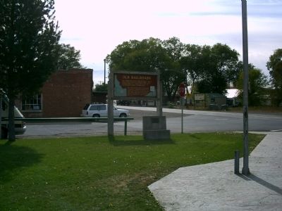
On U.S. 95 at milepost 136 at Illinois Avenue, on the right when traveling north on U.S. 95.
An ambitious railroad project to a high Seven Devils copper mine (elevation 6800 ft.) created a lot of excitement here in 1898-1899.
This would have been Idaho's highest mountain railroad if funding had been available to complete it. Construction . . . — — Map (db m23226) HM
On Henderson Road at High Street, on the left when traveling south on Henderson Road.
An act of Congress, approved April 1878, gave the Utah & Northern Railroad Co. permission to build a narrow gauge line through Marsh Valley. It reached Oneida by July of 1878, where the first station was built. The town attained a population of . . . — — Map (db m140074) HM
On Old Highway 91 (Grant Road) near Old Highway 30 West (Business Interstate 15), on the left when traveling north.
Through this canyon once puffed the wood-burning locomotives of the narrow-gauge Utah and Northern Railway.
Construction, undertaken by a Mormon Co-op, came northward from a junction with the transcontinental line, but stopped in 1874 at . . . — — Map (db m108284) HM
On Center Street near 7th Street, on the left when traveling south.
The development of McCammon was closely associated with the transportation industry. William Murphy, in early 1863, built the first toll bridge, and McCammon became the nucleus of the Overland Stage Lines. H.O. Harkness acquired the toll bridge . . . — — Map (db m108262) HM
On South 5th Avenue at South 4th Avenue (U.S. 30), on the left when traveling north on South 5th Avenue.
Pocatello's origin lies in the railroads an the role they played in westward expansion.
In the late-1800's, what would become Pocatello was a rest stop on the Utah and Northern Railroad, which went from Utah to Butte, Montana. In 1882, . . . — — Map (db m108325) HM
On 5th Avenue near East Terry Street, on the right when traveling west.
This monument marks the route of the first Idaho railroad. The Utah & Northern narrow gauge was started as a Mormon co-op at Ogden, Utah in 1871. It reached Franklin, Idaho in 1874. Union Pacific interests extended the line to Garrison, Montana . . . — — Map (db m125573) HM
On Washington Street (U.S. 89) near North 10th Street, on the right when traveling west.
Strong Building and Stock Chevrolet
This red brick building, note the brickwork circles, was built for Lish Strong by the Tueller brothers of Paris, Idaho. It became known as the Strong Building. Part of the upper level was also used for . . . — — Map (db m90911) HM
On Ovid Road (U.S. 89) at State Highway 36, in the median on Ovid Road.
Past travel and settlement across the rugged lands of the Bear Lake Valley were strongly influenced by the valley's hydrologic features. The shifting rivers, sloughs, and marshes presented natural barriers and were prone to flooding. This often . . . — — Map (db m140215) HM
On Ovid Road (Highway 89) at State Highway 36, in the median on Ovid Road.
The region comprising Bear Lake County has alway been an important juncture for overland travel. From the 1800s onward, migrants on the Oregon and California trails traversed the area, relying on knowledge garnered by Native Americans, early . . . — — Map (db m140213) HM
T"nt"nmi, was one of the last Coeur d'Alenes to leave permanent residence along the lake, after tribal members were assigned farm homes under the Allotment Act.
At Hnpetptqwe’n, he hosted regular gatherings and celebrations, where guests . . . — — Map (db m110411) HM
On Main Avenue near North Sixth Street (State Highway 5), on the right when traveling east.
St. Maries, named by Jesuit Father Pierre DeSmet during the 1840s, sits at the confluence of the "Shadowy" St. Joe and St. Maries rivers. It was recognized as a settlement in the 1880s. Incorporated as a village in 1902, and as a city in 1913, it . . . — — Map (db m122624) HM
On 675 East Street near 825 North, on the left when traveling north.
In 1879 the U.&N. Railroad Co. named their water stop, Basalt. Henry R. Whitmill settled in Cedar Point in 1884. Andrew O. Inglestrom filed on land, 1885. Others followed, built canal, homes, L.D.S. church house, cheese factory, two stores, saloon, . . . — — Map (db m231263) HM
On State Highway 75 at milepost 131 near West Sage Road, on the right when traveling south.
When Sun Valley Lodge was built in 1936, Union Pacific engineers developed chair lifts to transport skiers uphill.
Starting with two modest ski slopes on Dollar Mountain and Proctor Mountain, chair lifts were used for all Sun Valley ski . . . — — Map (db m110054) HM
Near U.S. 2, 3 miles east of Le Clerc Road, on the right when traveling east.
...the falls
As you look down at the Pend Oreille (Pond O'Ray) River and Albeni Falls Dam (Albany) you may be looking for the falls. In 1887 a 26 year-old French Canadian farmer living in Blanchard, Idaho, also wondered where the falls . . . — — Map (db m109902) HM
Near Main Street near Riverside Street, on the right when traveling north.
The Lower Kootenai people, on their seasonal migrations, were the first to travel through this area. They walked time-worn forest trails and paddled their sturgeon-nosed canoes on the Kootenai River and through the valley marshlands.
In 1808 . . . — — Map (db m122713) HM
On Main Street near Riverside Street, on the right when traveling north.
James J. Hill realized his vision of a northernmost transcontinental railroad in 1892, after the 1889 discovery of the Marias pass in Montana. The gentle grade and wide valley of the 5,213 ft. pass through the Rocky Mountains contrasted with the . . . — — Map (db m122715) HM
The Kootenai Valley Railroad, a subsidiary of the Great Northern, connected the main line from a spur near Bonners Ferry to the southern end of Kootenay Lake in British Columbia. Completed in 1899, its purpose was to connect with the Canadian Kaslo . . . — — Map (db m122716) HM
Near Main Street near Riverside Street, on the right when traveling north.
In the early days, this area was forested with vast swaths of huge virgin timber. As timber became less available along waterways, logging spur lines and railroad sidings were constructed to access more distant timber. Many logging camps sprang up . . . — — Map (db m122720) HM
Near Main Street near Riverside Street, on the right when traveling north.
A vast labor force was needed during construction of the railroads. Workers came from many ethnic groups, bringing a piece of "home" with them as they contributed to the growing culture of Boundary County.
Laborers hired for low wages, . . . — — Map (db m122718) HM
Near Main Street near Riverside Street, on the right when traveling north.
Railroads brought many changes to rural life, providing access to roadless areas. Depots were built in towns like Leonia, Meadow Creek, and Addie. Passenger cars carried people comfortably on business and pleasure trips, dramatically reducing travel . . . — — Map (db m122719) HM
Semaphores were signaling devices used along railroads to control the movement of trains. The position of the blades and colored lenses told the engineer whether he should continue at the present speed, slow down and proceed with caution or move to . . . — — Map (db m122721) HM
Near Main Street near Riverside Street, on the right when traveling north.
In 1905 Inland Empire construction magnate, D.C. Corbin, set out to build a railway line from Spokane to the international border. His plan was import coal from British Columbia to markets in eastern Washington.
The Spokane International Railroad . . . — — Map (db m122717) HM
Near Main Street near South 7th Avenue, on the right when traveling north.
In 1884, the Oregon Short Line Railroad reached "Bugtown," later renamed Caldwell after C.A. "Alexander" Caldwell, who served as the President of the Idaho & Oregon Land Improvement Company at the time.
The current depot facility is actually the . . . — — Map (db m110213) HM
The historic Guffey Bridge is an elegant Parker-through truss railroad bridge, the State’s largest artifact, and the site of the most spectacular train wreck in Idaho.
The Boise, Nampa and Owyhee Railroad (BNO), was organized by owner Col. Wm. . . . — — Map (db m73344) HM
On East 2nd Street South (U.S. 30) near South Main Street, on the right when traveling west.
Only memories remain...
In 1920, the ambitious Anaconda Copper Mining Company built the community of Conda to house its phosphate miners and their families. About 300 people resided in Conda during the mining heyday. The town closed in . . . — — Map (db m106695) HM
On South Main Street near West Center Street, on the left when traveling south.
This miniature locomotive played an integral part in the history of Caribou County. When the dam at Alexander Reservoir was built in 1924, it hauled supplies to the dam. Trapped by rising water, the locomotive was abandoned. In 1976 the reservoir . . . — — Map (db m106700) HM
The gently sloping mound around the geyser is travertine. The stone often develops into flights of pools enclosed within little dams.
These dams form through a mix of water and carbon dioxide which makes carbonic acid, and dissolved calcium . . . — — Map (db m109952) HM
Near West Camas Creek Road (Forest Road 006) near Interstate 15, on the left when traveling east.
After Montana's Gold Rushes began in 1862, thousands of miners came past here and a Beaver Canyon stage station was built here.
Freighters and travelers on stage lines from Salt Lake to Montana stopped at this station until Utah and . . . — — Map (db m124337) HM
On U.S. 12 at Summit Grade, on the left when traveling west on U.S. 12.
In 1898, after rail service from Lewiston reached Lenore, a tramway was begun to ship grain from Camas Prairie (1600 feet above) to a new freight stop directly across the river.
Previously, grain wagons descended a long steep hill from the . . . — — Map (db m109760) HM
Near Riverside Avenue near Dent Bridge Road / Brown Avenue, on the left when traveling north.
Routes Through History
Travel through the rugged Clearwater River region has not always been on smooth, paved highways. Routes on land began as game trails, then foot paths which grew into horse paths. Many of these historic routes paid . . . — — Map (db m159490) HM
On Custer Motorway Adventure Road - Mill Creek Road (Forest Road 070), on the left when traveling west.
Completion of the Toll Road in 1879 brought a period of prosperity to the Yankee Fork. Now heavy equipment needed to construct a mill could be transported in and large quantities of gold bullion shipped out to market. It also allowed goods and . . . — — Map (db m109781) HM
On South Commerical Street at West Madison Avenue, on the left when traveling south on South Commerical Street.
After the golden spike was driven at Promontory Utah in 1869 the nearest railroad station to Boise was Kelton on the north shore of the Great Salt Lake. A ferry was built 1/2 mile up on the river as a joint effort by Gustavus Glenn, a local rancher . . . — — Map (db m31678) HM
On North Main Street/Old U.S. 30 at American Legion Boulevard on North Main Street/Old U.S. 30.
Eight miles east of here, Rattlesnake Station, was an important stop for wagon trains and travelers along the Oregon Trail because of its sure supply of fresh water. Later, a stage station with a post office called "The Mountain Home" was . . . — — Map (db m129572) HM
On Sun Valley Highway (U.S. 20 at milepost 102.7) north of Industrial Way, on the left when traveling south.
At the junction of the Rocky Bar Road with the Oregon Trail, this was a major stage line stop for 20 years.
Stage service commenced in 1864, and a road to the Rocky Bar mines was opened 2 months later. In 1878 the station owners thought it . . . — — Map (db m70449) HM
On Highway 91 (U.S. 91 at milepost 13.2) near Hot Springs Road, on the right when traveling north.
One mile south and directly west of this highway, an old 1878 railway grade is still visible, although trains have not used it since 1890.
Jay Gould -- a nationally prominent financier and Union Pacific owner -- extended Utah and Northern . . . — — Map (db m105708) HM
On U.S. 95 at Old White Bird Hill Road, on the right when traveling north on U.S. 95.
A vast mountain wilderness, cut by the mile deep Salmon River Canyon stretches across Idaho south and east of here.
Travel through the Salmon River Mountains always was hard in the early days.
An 1872 railroad survey showed the Salmon . . . — — Map (db m109667) HM
On State Highway 6 at Onaway Road, on the left when traveling west on State Highway 6.
Built as a model town, Potlatch was owned by Weyerhaueser's Potlatch Lumber Company.
Spokane architect C. Ferris White designed the new community in 1905.
Workers’ housing stood close to the mill.
Managers’ homes were built away from . . . — — Map (db m109672) HM
On State Highway 6 at Travis Road, on the left when traveling west on State Highway 6.
Trail of the Coeur d’Alenes
Trail of the Coeur d’Alenes is a 73 mile long bike trail built on the original Union Pacific railroad grade.
During 1884 silver was discovered in the valley.
During 1888, construction began on a rail line . . . — — Map (db m110413) HM
On State Highway 6 at Onaway Road, on the left when traveling west on State Highway 6.
Potlatch Lumber Company's sawmill built here in 1906, was one of the largest in the world.
Expanding operations to the West, Weyerhaeuser timber barons invested in Idaho’s prime white pine stands.
By 1920, their mill was cutting 175 . . . — — Map (db m109673) HM
On U.S. 95 at milepost 268 near Evergreen Road, on the left when traveling north.
In order to cross Lawyer’s Canyon and other Camas Prairie gorges, a series of high railroad bridges was (sic) built in 1908. This highway goes past two of them here. Most were timber, but a metal structure, 1500 feet long and 296 feet . . . — — Map (db m121210) HM
On U.S. 95 at milepost 286, on the left when traveling north.
Seven tunnels - one a horseshoe more than a quater mile long -- had to be blasted in this canyon so that a railroad could be completed to Grangeville in 1908. Building a railroad up this canyon was exceptionally difficult and expensive. . . . — — Map (db m121219) HM
On U.S. 93, 0.2 miles south of State Highway 24, on the right when traveling north.
Historic District of Branch rail lines to Wood River and Camas Prairie served distant farmers and miners, while a stage line to Shoshone Falls accommodated wealthy tourists who visited Idaho’s foremost nineteenth century attraction.
Vast sheep . . . — — Map (db m109628) HM
On Watson's Store Road near 403 Road, on the right when traveling north.
This small train stop linked the Nez Perce with the cities of Lewiston, Idaho, and Spokane, Washington. Running directly through the reservation, the rails also opened this area to a wave of farmers and loggers who made striking changes to Nez Perce . . . — — Map (db m121736) HM
Near Moon Pass Road (Federal Road 456) 0.4 miles south of Loop Creek Road (Federal Road 326).
When two trains met on the single track Milwaukee mainline one train would have to “go in the hole”. One train moved onto a side track or siding, letting the other train pass by.
Timing a “meet” was extremely . . . — — Map (db m45635) HM
Near Cliff Creek Road (Federal Road 506) 3.7 miles north of Loop Creek Road (Federal Road 326).
Bitterroot winters are frigid and long-lasting, with the snow staying on the ridges and packed into the draws and gullies well into the spring.
Roland and East Portal can receive up to a foot of snow an hour during a big storm. The snowpack . . . — — Map (db m45561) HM
Near Cliff Creek Road (Federal Road 506) 2.6 miles north of Loop Creek Road (Federal Road 326).
“Change is inevitable. Change is constant.” Benjamin Disraeli
At the beginning of the 20th century, majestic western white pine, western larch and western red cedar, some over 400 years old, along with Douglas-fir and . . . — — Map (db m45563) HM
Near Cliff Creek Road (Federal Road 506) 4 miles north of Loop Creek Road (Federal Road 326).
It groaned,
It growled,
It Shrieked!
Turntable & Townsite
Roland, Idaho s started as a construction camp in 1906, housing men working on the west portion of the St. Paul Pass Tunnel. It evolved from a tent camp scattered along . . . — — Map (db m45556) HM
Near Cliff Creek Road (Federal Road 506) 1.8 miles north of Loop Creek Road (Federal Road 326).
Wood to Steel
The Milwaukee Road built temporary wood trestles at all but Kelly Creek and Clear Creek. Fire danger prompted the railroad to immediately begin replacing the wooden structures with earth-filled embankments or building steel . . . — — Map (db m45614) HM
Near Moon Pass Road (Federal Road 456) 0.4 miles south of Loop Creek Road (Federal Road 326).
In 1925, the Chicago, Milwaukee and St. Paul Railway Company suffered the largest business failure in the history of the United States up to that time.
The bankruptcy resulted from a combination of problems related to the construction of . . . — — Map (db m45650) HM
Near Moon Pass Road (Federal Road 456) 0.4 miles south of Loop Creek Road (Federal Road 326).
A logging railroad known as Bogle Spur snaked from here up the North Fork of the St. Joe River for seven miles. The spur was built to salvage timber killed during the 1910 fires. The little railroad operated from 1912 to 1915. When the logging . . . — — Map (db m45654) HM
Near Loop Creek Road (Federal Road 326) 4 miles west of Cliff Creek Road (Federal Road 506).
When Water Powered the Road
It made a great deal of sense to the Milwaukee Road’s directors to electrify portions of the mainline when building the western extension.
They could reduce the high cost of oil-fired, steam powered . . . — — Map (db m45624) HM
Near Loop Creek Road (Federal Road 326) 4 miles west of Cliff Creek Road (Federal Road 506).
“Fire in the Hole!”
In 1908, a Milwaukee contractor named Johnson needed to blast out a path through the rock face next to the Barnes Creek Trestle, #218. Blasters chiseled out five “coyote holes”, stuffed them . . . — — Map (db m45629) HM
Near Moon Pass Road (Federal Road 456) 0.4 miles south of Loop Creek Road (Federal Road 326).
For the price of a Pullman ticket, a common rail passenger could be waited upon and pampered in the grand manner of privileged gentry.
The Pullman porter provided the labor for that luxury…
After the Civil War, the Pullman Palace . . . — — Map (db m45648) HM
Near Loop Creek Road (Federal Road 326) 4 miles west of Cliff Creek Road (Federal Road 506).
[Cyrillic text]
(Little Joes, The Locomotives Big Joe Stalin Never Got!)
Made for Joseph Stalin’s Soviet Union, the United States embargoed these magnificent locomotives as strategic material at the start of the “Cold . . . — — Map (db m45633) HM
Near Cliff Creek Road (Federal Road 506) 2.6 miles north of Loop Creek Road (Federal Road 326).
If you stood on this spot with a railroad surveyor in 1906, you would have gazed across a lush patchwork forest of large trees. The super hot 1910 fires burned the valley below and for years afterward the area presented travelers with a bleak view . . . — — Map (db m45567) HM
Near Loop Creek Road (Federal Road 326) 4 miles west of Cliff Creek Road (Route 506).
It took a lot of mechanical muscle to pull the Milwaukee Road’s long, heavy passenger and freight trains over the rugged Rocky Mountains and tough Bitterroot Range. The Milwaukee Road used a great variety of powerful locomotives to do the . . . — — Map (db m45625) HM
Near Loop Creek Road (Federal Road 326) 4 miles west of Cliff Creek Road (Federal Road 506).
Depending on who you talk to, the hills around you contain either rich copper deposits or a lot of hot air....
Between 1889 and 1922, miners explored a number of promising mining properties near Adair. They encountered ore containing . . . — — Map (db m45622) HM
Near Cliff Creek Road (Federal Road 506) 1.8 miles north of Loop Creek Road (Federal Road 326).
It's nature’s “fault” this tunnel is closed…
Several major geologic fault lines run under these mountains. The mountainside here is slowly shifting along a fault line into the right side of this tunnel, collapsing it. . . . — — Map (db m45613) HM
Near Moon Pass Road (Federal Road 456) 0.4 miles south of Loop Creek Road (Federal Road 326).
The Lucky Swede and Pearson Mining Companies used this siding to bring in mining equipment and hopefully, send out copper ore…
According to old-timer Harold Theriault,
“The lucky Swede Mine was a fairly large company, but . . . — — Map (db m45656) HM
Near Loop Creek Road (Federal Road 326) 4 miles west of Cliff Creek Road (Federal Road 506).
Driving across the country today, fueling up at fast food outlets, it is hard to imagine that travel was once much more luxurious. The Milwaukee Road's Olympian and Columbian passenger trains carried elegant dining cars the entire distance from . . . — — Map (db m45632) HM
Near Moon Pass Road (Federal Road 456) 0.4 miles south of Loop Creek Road (Federal Road 326).
The Milwaukee Road transported tons of war material and thousands of troops during World Wars I and II, the Korean War and the Vietnam War.
During World War I, the Federal Government seized railroads in the United States including the . . . — — Map (db m45641) HM
Near Cliff Creek Road (Federal Road 506) 4 miles north of Loop Creek Road (Federal Road 326).
Primitive construction camps dotted the Bitterroot Mountains between 1906 and 1912.
Hardy colorful gangs of workers from around the globe called these bleak and often ugly temporary settlements home.
The hard work and disagreeable . . . — — Map (db m45553) HM
Near Moon Pass Road (Federal Road 456) 0.4 miles south of Loop Creek Road (Federal Road 326).
High steel trestles, long curved tunnels and steep rocky embankments could be accidents waiting to happen…
But diligent, hard-working Milwaukee Roaders saw that relatively few wrecks shattered the quiet beauty of the Bitterroots. . . . — — Map (db m45649) HM
Near Moon Pass Road (Federal Road 456) 0.4 miles south of Loop Creek Road (Federal Road 326).
You are standing on what was Falcon, Idaho, a lonely but important Milwaukee Road siding named for the raptors that nested in the area. Train passengers gave the place scant notice, but by 1915, a depot, a section house and several other . . . — — Map (db m45634) HM
Near Cliff Creek Road (Federal Road 506) 1.8 miles north of Loop Creek Road (Federal Road 326).
Patrolling for problems on the track was the job of the section foreman and his “section gang” of 2 to 7 hardy laborers.
In the early 1900s the Milwaukee Road’s mainline was divided into 5.5 to 9.5 mile-long sections. A . . . — — Map (db m45610) HM
Near Loop Creek Road (Federal Road 326) 4 miles west of Cliff Creek Road (Federal Road 506).
Grief could come to a big, fast train suddenly. Railroaders needed to see and hear warnings and orders clearly and quickly.
The engineer and crew watched for standard signals over each section of track and kept their eyes and ears open . . . — — Map (db m45623) HM
Near Moon Pass Road (Federal Road 456) 0.4 miles south of Loop Creek Road (Federal Road 326).
“Highballing” fast freight trains..
…known as “Silks”, sped raw Asian silk from west coast seaports across the United States for processing into finished garments.
The silks had the right-of-way over freight . . . — — Map (db m45640) HM
Near Cliff Creek Road (Federal Road 506) 1.8 miles north of Loop Creek Road (Federal Road 326).
Get the Line Open Quickly!
That was the policy of the Milwaukee Road. To do this in 1907 and 1908, the Chicago, Milwaukee & Puget Sound Railroad built numerous sturdy, but short-lived, wood trestles to prepare the new line for track as . . . — — Map (db m45579) HM
Near Cliff Creek Road (Federal Road 506) 1.8 miles north of Loop Creek Road (Federal Road 326).
One of the largest forest fires in the history of the United States
...swept over Idaho and Montana on August 20 and 21, 1910, including the area where you now stand. The fire burned three million acres, destroyed eight billion . . . — — Map (db m45615) HM
Near Cliff Creek Road (Federal Road 506) near Loop Creek Road (Federal Road 326).
The forest fires of August, 1910, burned millions of acres in Idaho, Montana and Washington. On the night of August 20, engineer Johnnie Mackedon, returning from a trip to St. Paul Pass, found the Falcon siding on fire. Over one hundred terrified . . . — — Map (db m45617) HM
Near Moon Pass Road (Federal Road 456) 0.4 miles south of Loop Creek Road (Federal Road 326).
Time Runs Out for “America s Resourceful Railroad”
Never-ending financial problems, speedy new interstate highways and jets killed Milwaukee's passenger service to the Pacific Coast by 1961. Stiff freight competition and . . . — — Map (db m45651) HM
Near Loop Creek Road (Federal Road 506) 4 miles west of Cliff Creek Road (Federal Road 326).
The Unknown Locomotive
Called the “unkown” locomotive by some rail enthusiasts, few people now recognize the heavyweight of the Milwaukee’s Rocky Mountain Division, the Baldwin-Westinghouse EP-3.
Between 1919 and . . . — — Map (db m45630) HM
Near Loop Creek Road (Federal Road 326) 4 miles west of Cliff Creek Road (Federal Road 506).
On June 29, 1947 the pride of the Milwaukee Road was introduced-- an all new streamlined train called the “Olympian Hiawatha”.
The name “Hiawatha” originated with Henry Wadsworth Longfellow’s poem “Song of . . . — — Map (db m45631) HM
Near Cliff Creek Road (Federal Road 506) 3.7 miles north of Loop Creek Road (Route 326).
Looking for the Right Route
In 1905, the Milwaukee and St. Paul Railway began looking for a route for their western extension over the Bitterroot Mountains. After five and a half months, exploring 930 miles, the railroad chose a route . . . — — Map (db m45559) HM
Near Moon Pass Road (Federal Road 456) 0.4 miles south of Loop Creek Road (Federal Road 326).
The Last Transcontinental Railroad
“It was the finest railroad in America.”
Those were the words of many former employees of the Chicago, Milwaukee, St. Paul and Pacific (Milwaukee Road). This trail follows the route of . . . — — Map (db m45652) HM
Near Moon Pass Road, 0.4 miles south of Loop Creek Road (Federal Road 326).
People used to say “Taft, Montana was the toughest town in the west until Grand Forks, Idaho developed.”
Located across the valley at the mouth of Cliff Creek, a Forest Service employee described it as,
“…a wild . . . — — Map (db m45636) HM
Near Cliff Creek Road (Federal Road 506) 1.8 miles north of Loop Creek Road.
An astonishing contraption called “The Traveler”, a giant rolling crane, erected Kelly and Clear Creek Trestles in record time.
The Milwaukee decided to build Kelly and Clear Creek Trestles out of steel right From the . . . — — Map (db m45618) HM
Near Loop Creek Road (Road 326) 4 miles west of Cliff Creek Road (Federal Road 506).
During the 1910 fires, fire fighters hopping off a train here at two in the morning wondered, “why anyone bothered to give this spot a name.”
In fact, Adair started out several years earlier as a boisterous railroad . . . — — Map (db m45620) HM
Near Cliff Creek Road (Federal Road 506) 1.8 miles north of Loop Creek Road (Federal Road 326).
Snaking its railroad down the western side of the Bitterroot Mountains, the Milwaukee Road burrowed 16 tunnels to maintain a uniform grade down to Avery.
These tunnels were dug largely by hand using sledgehammers and hand drills. In some cases . . . — — Map (db m45608) HM
Near Cliff Creek Road (Federal Road 506) 2.6 miles north of Loop Creek Road (Federal Road 326).
A powerful man-made jet of water blasted the mountainside…
…washing soil and loose rock downslope to fill in the trestle.
By 1911, the Milwaukee Road filled twenty-two temporary wooden trestles between St. Regis, Montana and Avery, . . . — — Map (db m45568) HM
Near Moon Pass Road (Federal Road 456) 0.4 miles south of Loop Creek Road (Federal Road 326).
Who’s Been Working On The Railroad?
If you stood here sometime between 1907 and 1911, you would have heard a multitude of languages.
The hundreds of people employed during the construction of the Milwaukee Road included; . . . — — Map (db m45637) HM
Near Moon Pass Road (Federal Road 456) 0.4 miles south of Loop Creek Road (Federal Road 326).
Do you have the right stuff to be a FOREST RANGER?!
Forest Service District Rangers today are resource professionals. She/he could be a forester, fish or wildlife biologist, hydrologist, botanist, landscape architect or other . . . — — Map (db m45643) HM
On Interstate 90, 7.9 miles east of Exit 69 at Mullan, on the right.
A spectacular avalanche, Feb. 10, 1903, swept away part of a trestle—300 feet high—that let Northern Pacific Railway trains descend from this pass since 1890.
An engine that plunged 80 feet was buried in 30 feet of snow; a passenger . . . — — Map (db m91447) HM
On State Highway 71 at milepost 2,, 10 miles west of Camp Creek Road, on the left when traveling north.
More than a century ago, miners faced a hopeless problem of hauling copper ore to this canyon for shipment to smelters.
They started with Albert Kleinschmidt's road grade down from their mine, more than a vertical mile above Snake River, and more . . . — — Map (db m23228) HM