By Rebecca Maxwell, October 11, 2009
Old Railroads Marker in Council
| On U.S. 95 at milepost 136 at Illinois Avenue, on the right when traveling north on U.S. 95. |
| On Henderson Road at High Street, on the left when traveling south on Henderson Road. |
| On Old Highway 91 (Grant Road) near Old Highway 30 West (Business Interstate 15), on the left when traveling north. |
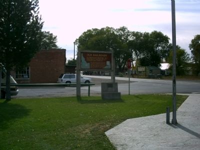
| On Center Street near 7th Street, on the left when traveling south. |
| On South 5th Avenue at South 4th Avenue (U.S. 30), on the left when traveling north on South 5th Avenue. |
| On 5th Avenue near East Terry Street, on the right when traveling west. |
| On Washington Street (U.S. 89) near North 10th Street, on the right when traveling west. |
| On Ovid Road (U.S. 89) at State Highway 36, in the median on Ovid Road. |
| On Ovid Road (Highway 89) at State Highway 36, in the median on Ovid Road. |
| Near Trail of the Coeur d'Alenes. |
| On Main Avenue near North Sixth Street (State Highway 5), on the right when traveling east. |
| On 675 East Street near 825 North, on the left when traveling north. |
| On State Highway 75 at milepost 131 near West Sage Road, on the right when traveling south. |
| Near U.S. 2, 3 miles east of Le Clerc Road, on the right when traveling east. |
| Near Main Street near Riverside Street, on the right when traveling north. |
| On Main Street near Riverside Street, on the right when traveling north. |
| On Main Street near Riverside Street. |
| Near Main Street near Riverside Street, on the right when traveling north. |
| Near Main Street near Riverside Street, on the right when traveling north. |
| Near Main Street near Riverside Street, on the right when traveling north. |
| On Main Street near Riverside Street. |
| Near Main Street near Riverside Street, on the right when traveling north. |
| Near Main Street near South 7th Avenue, on the right when traveling north. |
| On East 2nd Street South (U.S. 30) near South Main Street, on the right when traveling west. |
| On South Main Street near West Center Street, on the left when traveling south. |
| Near West Camas Creek Road (Forest Road 006) near Interstate 15, on the left when traveling east. |
| On U.S. 12 at Summit Grade, on the left when traveling west on U.S. 12. |
| Near Riverside Avenue near Dent Bridge Road / Brown Avenue, on the left when traveling north. |
| On Custer Motorway Adventure Road - Mill Creek Road (Forest Road 070), on the left when traveling west. |
| On South Commerical Street at West Madison Avenue, on the left when traveling south on South Commerical Street. |
| On North Main Street/Old U.S. 30 at American Legion Boulevard on North Main Street/Old U.S. 30. |
| On Sun Valley Highway (U.S. 20 at milepost 102.7) north of Industrial Way, on the left when traveling south. |
| On Highway 91 (U.S. 91 at milepost 13.2) near Hot Springs Road, on the right when traveling north. |
| On U.S. 95 at Old White Bird Hill Road, on the right when traveling north on U.S. 95. |
| On State Highway 6 at Onaway Road, on the left when traveling west on State Highway 6. |
| On State Highway 6 at Travis Road, on the left when traveling west on State Highway 6. |
| On State Highway 6 at Onaway Road, on the left when traveling west on State Highway 6. |
| On U.S. 95 at milepost 268 near Evergreen Road, on the left when traveling north. |
| On U.S. 95 at milepost 286, on the left when traveling north. |
| On U.S. 93, 0.2 miles south of State Highway 24, on the right when traveling north. |
| On Watson's Store Road near 403 Road, on the right when traveling north. |
| Near Moon Pass Road (Federal Road 456) 0.4 miles south of Loop Creek Road (Federal Road 326). |
| Near Cliff Creek Road (Federal Road 506) 3.7 miles north of Loop Creek Road (Federal Road 326). |
| Near Cliff Creek Road (Federal Road 506) 2.6 miles north of Loop Creek Road (Federal Road 326). |
| Near Cliff Creek Road (Federal Road 506) 4 miles north of Loop Creek Road (Federal Road 326). |
| Near Cliff Creek Road (Federal Road 506) 1.8 miles north of Loop Creek Road (Federal Road 326). |
| Near Moon Pass Road (Federal Road 456) 0.4 miles south of Loop Creek Road (Federal Road 326). |
| Near Moon Pass Road (Federal Road 456) 0.4 miles south of Loop Creek Road (Federal Road 326). |
| Near Loop Creek Road (Federal Road 326) 4 miles west of Cliff Creek Road (Federal Road 506). |
| Near Loop Creek Road (Federal Road 326) 4 miles west of Cliff Creek Road (Federal Road 506). |
| Near Moon Pass Road (Federal Road 456) 0.4 miles south of Loop Creek Road (Federal Road 326). |
| Near Loop Creek Road (Federal Road 326) 4 miles west of Cliff Creek Road (Federal Road 506). |
| Near Cliff Creek Road (Federal Road 506) 2.6 miles north of Loop Creek Road (Federal Road 326). |
| Near Loop Creek Road (Federal Road 326) 4 miles west of Cliff Creek Road (Route 506). |
| Near Loop Creek Road (Federal Road 326) 4 miles west of Cliff Creek Road (Federal Road 506). |
| Near Cliff Creek Road (Federal Road 506) 1.8 miles north of Loop Creek Road (Federal Road 326). |
| Near Moon Pass Road (Federal Road 456) 0.4 miles south of Loop Creek Road (Federal Road 326). |
| Near Loop Creek Road (Federal Road 326) 4 miles west of Cliff Creek Road (Federal Road 506). |
| Near Moon Pass Road (Federal Road 456) 0.4 miles south of Loop Creek Road (Federal Road 326). |
| Near Cliff Creek Road (Federal Road 506) 4 miles north of Loop Creek Road (Federal Road 326). |
| Near Moon Pass Road (Federal Road 456) 0.4 miles south of Loop Creek Road (Federal Road 326). |
| Near Moon Pass Road (Federal Road 456) 0.4 miles south of Loop Creek Road (Federal Road 326). |
| Near Cliff Creek Road (Federal Road 506) 1.8 miles north of Loop Creek Road (Federal Road 326). |
| Near Loop Creek Road (Federal Road 326) 4 miles west of Cliff Creek Road (Federal Road 506). |
| Near Moon Pass Road (Federal Road 456) 0.4 miles south of Loop Creek Road (Federal Road 326). |
| Near Cliff Creek Road (Federal Road 506) 1.8 miles north of Loop Creek Road (Federal Road 326). |
| Near Cliff Creek Road (Federal Road 506) 1.8 miles north of Loop Creek Road (Federal Road 326). |
| Near Cliff Creek Road (Federal Road 506) near Loop Creek Road (Federal Road 326). |
| Near Moon Pass Road (Federal Road 456) 0.4 miles south of Loop Creek Road (Federal Road 326). |
| Near Loop Creek Road (Federal Road 506) 4 miles west of Cliff Creek Road (Federal Road 326). |
| Near Loop Creek Road (Federal Road 326) 4 miles west of Cliff Creek Road (Federal Road 506). |
| Near Cliff Creek Road (Federal Road 506) 3.7 miles north of Loop Creek Road (Route 326). |
| Near Moon Pass Road (Federal Road 456) 0.4 miles south of Loop Creek Road (Federal Road 326). |
| Near Moon Pass Road, 0.4 miles south of Loop Creek Road (Federal Road 326). |
| Near Cliff Creek Road (Federal Road 506) 1.8 miles north of Loop Creek Road. |
| Near Loop Creek Road (Road 326) 4 miles west of Cliff Creek Road (Federal Road 506). |
| Near Cliff Creek Road (Federal Road 506) 1.8 miles north of Loop Creek Road (Federal Road 326). |
| Near Cliff Creek Road (Federal Road 506) 2.6 miles north of Loop Creek Road (Federal Road 326). |
| Near Moon Pass Road (Federal Road 456) 0.4 miles south of Loop Creek Road (Federal Road 326). |
| Near Moon Pass Road (Federal Road 456) 0.4 miles south of Loop Creek Road (Federal Road 326). |
| On Interstate 90, 7.9 miles east of Exit 69 at Mullan, on the right. |
| On State Highway 71 at milepost 2,, 10 miles west of Camp Creek Road, on the left when traveling north. |