On Gregory Boulevard at Marvin Street, in the median on Gregory Boulevard.
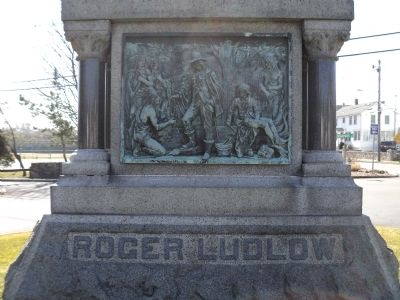
This stone, erected December, 1895, commemorates the purchase from the aboriginal inhabitants, made February 26, 1640-1, by Roger Ludlow, Deputy-Governor of the Colony of Connecticut, framer of its first Code of Laws, and Founder of Norwalk, of . . . — — Map (db m53440) HM
On Putnam Park Road (Connecticut Route 107) 0.1 miles east of Lonetown Road, on the right when traveling west.
Home site of
“Lonetown Manor” where
John Read, Gentleman
after whom the town is named
settled in 1711
Title to the original 500 acres
was secured by colony grants
confirmed in 1714 by an Indian
deed from Chief . . . — — Map (db m26870) HM
On Lonetown Road (Connecticut Route 107) at Hill Road, on the left when traveling south on Lonetown Road.
Originally part of Fairfield and unclaimed land, Redding was settled about 1711, made a parish in 1729, and incorporated in 1767. It was named for John Read, gentleman, lawyer, early landowner, and spokesman for the settlers. One of his land . . . — — Map (db m26814) HM
On Main Street, on the right when traveling north.
Built as a farmhouse in 1713 on Lot#2 by David Hoyt, it was sold to his grandson Timothy Keeler, who converted it into an inn/tavern in 1772. The Keeler Tavern, which also served as a post office, was inherited by Anna Keeler, Timothy’s . . . — — Map (db m23411) HM
On Old Branchville Road near Nod Hill Road, on the left when traveling west.
Old Hundred
1783
This Structure Was Originally
The Store of Lts. Joshua King And
James Dole, Later Used As A Resi-
dence Known As "Old Hundred." — — Map (db m30464) HM
On Catoonah Street at Main Street (Connecticut Route 35), on the right when traveling east on Catoonah Street.
The Fire District in Ridgefield was organized in 1896 following the devastating fire of 1895. Ex-Governor Phineas Lounsbury was an early benefactor of the Department and the new engine company took his name. The firehouse is also the site of . . . — — Map (db m32050) HM
On Ridgebury Road at George Washington Highway, on the right when traveling south on Ridgebury Road.
Ridgebury, "The New Patent," was one of the last land purchases made by the Proprietors. Tradition says that the First Congregational Church in Ridgebury had its beginnings in the "New Patent Meeting House" as early as 1738. In 1768 the . . . — — Map (db m32052) HM
On Main Street (Connecticut Route 35) at Branchville Road (Connecticut Route 102), on the right when traveling north on Main Street.
The First Recorded Plan for settlement was in 1697 when a group of Congregationalists primarily from Norwalk petitioned "to purchase of the Indians a certain tract of land lying about 14 miles northward of the town of Norwalk to settle a . . . — — Map (db m32048) HM
On Main Street at Prospect Street, on the right when traveling north on Main Street.
The Smith Tavern stood on the site of the present library. Ebenezer Smith arrived from Milford in 1709 and was assigned Lot # 26. He opened a small tavern in his home. By 1797 a new building was erected on the site by Amos Smith, who ran a . . . — — Map (db m24806) HM
On Main Street (Connecticut Route 35) 0.1 miles north of Gilbert Street, on the left when traveling south.
Built by Benjamin Stebbins for his daughter Sarah and her husband Amos Baker, a Revolutionary War Hero, the first surgeon in Ridgefield and the originator of the famous Baker Apple. — — Map (db m23602) HM
On Main Street (Connecticut Route 33/35) just north of Market Street, on the right when traveling north. Reported damaged.
On these grounds in 1786 the Town Proprietors built the Independent School House from materials taken from the razed old town house that stood on the Village Green. In 1896 Governor Phineas Lounsbury built his estate, Grovelawn, on this site. . . . — — Map (db m230125) HM
Near Howe Avenue (Connecticut Route 110) at New Street, on the right when traveling north.
Fort Hill
On This Point Of Land
The Pootatuck Indians
Built A Fort In 1673
To Prevent The White Man
From Coming Up
The Ousatonic River — — Map (db m28322) HM
On Howe Avenue (Route 110) at Roberts Street, on the right when traveling north on Howe Avenue.
[ front ]
Shelton
1639 – Stratford area settled, with present-day Shelton as the northern part.
1717 – Northern settlers established Ripton parish.
1789 – Ripton separated from Stratford and became the town . . . — — Map (db m25614) HM
On Connecticut Route 39 at Gaylordsville Road, on the left when traveling north on State Route 39.
Originally part of New Fairfield, which was purchased from the Indians in 1729, the area then known as the Upper Seven Miles was separately incorporated as the Town of Sherman in 1802. The town was named for Roger Sherman who, as a young man, had . . . — — Map (db m23070) HM
On Atlantic Street at Main Street, on the right when traveling north on Atlantic Street.
1776 1976
First Congregational Church
A crude, square, wooden structure surrounded by a stockade was erected near this site in 1641-2. It was the first meeting house of the Church of Christ. Later the First Congregational Church. Four members . . . — — Map (db m38752) HM
On Grove Street at Main Street, on the left when traveling north on Grove Street.
1776 1976
St. John's Episcopal Church
In 1774, St John's, the first Episcopal Church in this area, was built here on land granted by the town. Struck by lightning that same year, the original building was repaired and endured for a hundred . . . — — Map (db m38767) HM
On Atlantic Street at Main Street, on the right when traveling north on Atlantic Street.
This tablet has been placed by Stamford Chapter National Society Daughters of the American Revolution to commemorate
The Settlement of Stamford in 1641
During that year, twenty nine men and their families came from Wethersfield to this place. . . . — — Map (db m38609) HM
On Shore Road, 0.1 miles east of Elm Street, on the right when traveling east.
Traditional Landing Place of Stratford’s First Settlers
In the spring of 1639 under leadership of the Rev. Adam Blakeman
On the right, at the inner end of the harbor stood the First Meeting House and burial ground, and across the harbor . . . — — Map (db m48426) HM
On Academy Hill at Elm Street, on the left when traveling east on Academy Hill.
Academy Hill
Historic District
Established April 14, 1988
First known as Watch House Hill, where the first settlers manned a blockhouse and a palisade to guard the town from threats of Dutch and Indian attack.
Renamed Meeting House . . . — — Map (db m25814) HM
Near Main Street (Connecticut Route 110) at Manor Hill Road, on the right when traveling north.
Listed on the National Register of Historic Places
By the United States
Department of the Interior
May 1, 1985
This Estate Owned by the Boothe Family
For Many Generations Was Willed
To the Town of Stratford by
David Beach . . . — — Map (db m25907) HM
Near Main Street (Connecticut Route 110) at Manor Hill Road, on the right when traveling north.
This 1820’s home was built over the original foundation of the 1683 house and has been altered four times since then. David and Stephen Boothe’s renovations of 1913 added stained glass windows, four safes in the walls, and several . . . — — Map (db m25911) HM
On Academy Hill, 0.1 miles east of Main Street (Connecticut Route 113), on the left when traveling east.
In Memory Of
Captain John Carpenter
Born in London, England, 1628
Settled In
Stratford, Connecticut
Before 1646
He commanded the Jamaica Fusiliers
In the Defense of Fort James, New
York, When the Dutch Fleet Of
William of Orange . . . — — Map (db m25766) HM
On Broad Street at Monument Place, on the right when traveling east on Broad Street.
This Gate Is the Gift of Columbia University In the City of New York In Grateful Memory of Samuel Johnson the First President of King’s College In the Province of New York 1754 – 1763 A.D. And of His Son William Samuel Johnson the First . . . — — Map (db m25815) HM
[Left Plaque]
In honor of
the men and women
who planted in the wilderness
the early homes of Stratford,
who fought bravely and suffered patiently
in the War of the American Revolution,
and who left to their descendents
a . . . — — Map (db m26099) HM
On White Plains Road (Connecticut Route 127) at Unity Road, on the right when traveling north on White Plains Road.
The northwest farmers of Stratford formed the Village of Unity in October, 1725. They united in 1744 with the Long Hill parish of the Stratfield section of Stratford to become the Society of North Stratford. The Society controlled its own religious . . . — — Map (db m88049) HM
On Norfield Road, 0.1 miles east of Weston Road (Connecticut Route 57), on the left when traveling east.
[ front ]
Weston
Originally the Nor'field parish of old Fairfield (1639) to the south, present Weston was divided into long lots circa 1670, commencing our agricultural development. By 1757 there were enough families to become a separate . . . — — Map (db m30800) HM
On Jesup Road at Taylor Place, on the right when traveling east on Jesup Road.
Jennings Trail
Jesup Green
Here stood the William H. Jessup House
Later owned by William Taylor.
On the river the Jessups built wharves
and warehouses in the late 18th
century where grain was stored awaiting
export by sail. The . . . — — Map (db m30645) HM
Near Myrtle Avenue, 0.1 miles north of Avery Place, on the right when traveling north.
Indigenous people frequented this area for thousands of years before the arrival of Europeans in the 17th century. In 1637, native Paugussets were driven away after the Great Swamp Fight between the larger Pequot tribe and European colonizers. In . . . — — Map (db m226768) HM
On Myrtle Avenue at Avery Place, on the left when traveling north on Myrtle Avenue.
Wheeler House
Orig Date 1795
Remodeled 1860's
Westport Historical Society
[ lower medallion ]
The National Register
Of Historic Places
Recorded Property — — Map (db m31203) HM
On Danbury Road (U.S. 7) at Cricket Lane, on the left when traveling south on Danbury Road.
[ front ]
Wilton
Although this region was settled in 1651 as part of Norwalk, the first dwelling house here was built in 1706. The village of Wilton with parish privileges was granted by the general Assembly on May 12, 1726. The Town of . . . — — Map (db m32256) HM
On West Main Street (U.S. 202) at Ensign Drive, on the right when traveling west on West Main Street.
Avon
This area, formerly Northington or the North Parish of Farmington, was settled in 1645non land that had belonged to the Tunxis Indians. It prospered as a farming community and, in 1830, after the construction and opening of the Farmington . . . — — Map (db m33019) HM
On Kensington Road at Main Street, on the left when traveling north on Kensington Road.
Berlin
This land, granted to settlers in 1661 and 1668 by the General Court of Connecticut, was also purchased from the local Mattabesett Indian tribe. Founders of the community include Sergeant Richard Beckley, who came north on the trail from New . . . — — Map (db m46041) HM
On Park Avenue (Connecticut Route 178) at Bloomfield Avenue (Connecticut Route 189), on the left when traveling north on Park Avenue.
Bloomfield
In 1736 fifty-one inhabitants petitioned for parish privileges in what is now Bloomfield. They called the parish Wintonbury, using parts of the names of the three towns they came from Windsor, Farmingtonand Simsbury. It remained . . . — — Map (db m97354) HM
On North Main Street at Laurel Street, on the right when traveling south on North Main Street.
[ front ]
Bristol
Bristol was originally a part of Farmington. In 1663 an easterly portion called "Poland" was granted to Thomas Barnes and three others. The area which later became Bristol was allotted in 1721 to Farmington settlers. In . . . — — Map (db m33237) HM
On Bellevue Avenue at Queen Street, on the right when traveling north on Bellevue Avenue.
New Cambridge (now Bristol)
Was Settled 1727 – 8
Since Early Days
The Federal Hill Green
Has Been Used As A
Training Ground For Soldiers And A
Playground For Children
This Boulder Was Placed
By Katherine Gaylord Chapter . . . — — Map (db m34240) HM
On George Washington Turnpike at ielman Highway (Connecticut Route 4), on the right when traveling east on George Washington Turnpike.
[ front ]
Burlington
The original inhabitants of the part of Farmington known as West Woods were Tunxis Indians. Early settlement by white man was scattered. The first house of record, noted in an estate inventory of 1725, was that of . . . — — Map (db m33174) HM
On Albany Turnpike (U.S. 44) at Canton Green Road, on the right when traveling east on Albany Turnpike.
Settlement of the area later called Canton, originally part of Simsbury, began in 1737 with the erection of the Richard Case II home on East Hill. The earliest homes were constructed along “Cherry’s” brook. The settlers’ name for the . . . — — Map (db m87925) HM
On Lovely Street, on the left when traveling north.
Route 44 began as the Indian’s Northwest Path. It became the Hartford to Albany Road during the French and Indian War in order to move troops and equipment. In 1984, it became the Albany Turnpike, a toll road.
1776 House was an old home . . . — — Map (db m102423) HM
On Center Street at Memorial Drive, on the left when traveling south on Center Street.
East Granby
This area, first settled in 1664, was one of four Congregational parishes in Simsbury. The Turkey Hills Ecclesiastical Society in 1786 became a section of Granby, and in 1858 was incorporated as the Town of East Granby. An unusual . . . — — Map (db m97408) HM
On Main Street at Carroll Road, on the right when traveling north on Main Street.
East Hartford
This part of the lands once inhabited by the Podunk Indians saw its first permanent colonists in 1655, when Thomas Hooker and his followers came from Cambridge, Massachusetts, to found Hartford. The east side of the Connecticut River . . . — — Map (db m74248) HM
On Main Street at Phelps Place, on the right when traveling north on Main Street.
Historic Center Cemetery
Authorized 1709
“Center Cemetery is one of Connecticut’s most interesting and important 18th century burial grounds, and is one of the most striking examples extant of the mixing of Connecticut River Valley . . . — — Map (db m74928) HM
On Scantic Road near Phelps Road, on the right when traveling south.
East Windsor
Separated from Old Windsor and constituted a township on the “second Thursday of May A.D. 1768”. In this area was the Nortin Society of Old Windsor, organized in May 1752. Ferry service established by John Bissell in 1641 . . . — — Map (db m113964) HM
On Enfield Street (U.S. 5) at S. Road, on the left when traveling north on Enfield Street.
Enfield
Settled 1680
Established as the township of Enfield, 1683, this area was part of the Springfield Plantation granted to William Pynchon and others by the Massachusetts General Court. Springfield was settled in 1636, but no effectual grants . . . — — Map (db m113909) HM
On Enfield Street at Spier Avenue, on the left when traveling south on Enfield Street.
Near this site the first church building in Enfield was erected by pioneer settlers in 1684.
Placed by Penelope Terry Abbey Chapter, D.A.R.
1680 1930 — — Map (db m113886) HM
On Enfield Street at Spier Avenue, on the left when traveling south on Enfield Street.
To Honor the Memory of the Founders of the Town of Enfield. Who led by John Pease, Jr. and his Brother Robert made the First Settlement in 1680.
Placed by Penelope Terry Abbey Chapter, D.A.R.
1680 1930 — — Map (db m113885) HM
On Montieth Drive at Farmington Avenue (Connecticut Route 4), on the right when traveling east on Montieth Drive.
On January 16, 1640 the Connecticut General Court empowered a committee to "view those parts by Vnxus Sepus wch may be suitable" for settlement. Soon afterward a small group of families traveled nine miles westward over the hills from . . . — — Map (db m33066) HM
In the middle 1800s, it is believed, the cave was the home of Farmington’s mystery man, Will Warren. He was a poor farmhand with no property of his own. He refused to attend the village church on Sundays and spent his free time with the few Native . . . — — Map (db m92260) HM
On Main Street near Hebron Avenue, on the right when traveling north.
Formerly part of Wethersfield, the town was named for Glastonbury in England. Its thirty four original farms, running from the River three miles east “into the wilderness,” were the first officially surveyed by Connecticut Colony, . . . — — Map (db m98863) HM
On Main Street at Whapley Road, on the left when traveling south on Main Street.
Kimberly Tract
This land is part of the original grant east of the great river made to John Robbins of Wethersfield in 1640. The original lot of 132 acres – 22 rods wide – extended three miles from the river into the hills. With Eleazar . . . — — Map (db m98902) HM
On Main Street at Morgan Drive, on the right when traveling south on Main Street.
Site of Second Meeting House
First Church of Christ
Congregational
1735 – 1837
News of the battles of Lexington and Concord
reached here while Rev. John Eells was
preaching and was announced from the pulpit
April 28, 1775 . . . — — Map (db m98901) HM
On Salmon Brook Street (Connecticut Route 10) at Meadow Gate Road, on the left when traveling south on Salmon Brook Street.
Granby
Settled as the Salmon Brook section of Simsbury early in the 18th century, and established as a separate ecclesiastical society in 1736, Granby became a separate town in 1786. From the beginning, farming was the main endeavor of the . . . — — Map (db m97450) HM
On Farmington Ave., 1 mile Asylum Ave., on the right when traveling east.
On this site, from 1869 until 1963, stood the Hartford Public High School, the second oldest secondary school in the United States. Founded in 1638 as a Latin Grammar School. It became, in 1847, the Hartford Public English and Classical High . . . — — Map (db m28374) HM
Near Main Street at Central Row, on the right when traveling north.
Adriaen Block
A short distance from
where you are standing,
in 1614
Adriaen Block, captain of the ship Restless
sails up a river from the Atlantic Ocean
which native peoples of the region have named
"Quinnehtukqut", meaning the Great . . . — — Map (db m53151) HM
On Main Street at Arch Street, on the right when traveling north on Main Street.
In memory of the courageous
Adventurers
who inspired and directed by
Thomas Hooker journeyed through the
wilderness from Newtown (Cambridge)
in the Massachusetts Bay to
Suckiaug (Hartford) – October 1635
Mathew Allyn • John . . . — — Map (db m52432) HM
Near Main Street at Central Row, on the right when traveling north.
Where you are standing, on October 31, 1687 came Sir Edmund Andros to the meeting house built on this site, sent by the British Crown to revoke Connecticut's Charter and establish the Dominion of New England. Captain Joseph Wadsworth, determined . . . — — Map (db m53150) HM
Near Main Street at Gold Street, on the right when traveling south.
1771 Memorial 1912
To The Deceased Members Of
The First Company Governor's Foot Guard
Hartford Connecticut
Erected By The
Veteran Corps
Dedicated June 1912
1771
Captain Samuel Wyllys . . . — — Map (db m43772) HM
On Main Street at Gold Street, on the right when traveling north on Main Street.
George Washington
was entertained by
Colonel Jeremiah Wadsworth in his home on this site on June 30, 1775 when on his way to Cambridge to assume command of the Army.
On September 21, 22, 23, 1780 with Lafayette, General Knox and Governor . . . — — Map (db m151930) HM
Near Main Street at Gold Street when traveling south.
[ south side ]
George Wyllys
Born 1590 in Fenny Compton Co Warwick England
Came to Hartford 1638
Deputy Governor of Connecticut 1641
And Governor 1642. Died March 9, 1645
Bridget Young his wife died at Fenny Compton
March 1629 . . . — — Map (db m43771) HM
On Main Street at Gold Street, on the right when traveling south on Main Street.
Hartford was named in 1637 after the English town of Hertford. The Indian name was Suckiaug. The first colonial settlement, called House of Good Hope, was made by the Dutch in 1633. The Reverend Thomas Hooker arrived overland from Newtown . . . — — Map (db m43708) HM
Near Main Street at Gold Street, on the right when traveling south.
In Memory of the First
Settlers of Hartford
Jeremy Adams • Matthew Allyn • Francis Andrews • William Andrews • John Arnold • Andrew Bacon • John Barnard • Thomas Barnes • Robert Bartlett • John Baysey • Thomas Beale • Nathaniel Bearding • Mary . . . — — Map (db m195603) HM
Near Main Street near Gold Street, on the right when traveling south.
Of Copford Hall. Essex England. Third Governor of Massachusetts. A founder of this commonwealth & its first Governor. A lover of religious liberty. A man trusted and honored.
Near this place he was buried & by this tablet The Connecticut . . . — — Map (db m44068) HM
On Main Street at Gold Street, on the right when traveling south on Main Street.
Rev. Samuel Stone 1602 – 1663
First Church Teacher and 2nd Pastor
Co-Founded Hartford with Thomas Hooker
Born in Hertford England — — Map (db m43742) HM
On Main Street at Gold Street, on the right when traveling south on Main Street.
Sacred to the Memory of
the Three Hundred or more
African Americans
Free People, Slaves, and
five Black Governors
Who rest in Unmarked
Graves in Hartford's
Ancient Burying Ground
1640 - 1810
[ back ]
School children in . . . — — Map (db m43803) HM
On Elm Street at Clinton Street, on the left when traveling east on Elm Street.
Scion of the Charter Oak
Planted 19 October 1871 by
First Company Governor's Foot Guard
White Oak (Quercus atba L)
In the earliest days the great oak served both as a council tree and agricultural guide for Native Americans. The annual spring . . . — — Map (db m64924) HM
Near Central Row near Main Street, on the right when traveling west.
In 1636
The Church in Newtown, Massachusetts
Thomas Hooker, Minister
was transplanted to this locality, called
Meeting House Yard,
Old State House Square
City Hall Square.
Near this site on May 31, 1638.
Thomas Hooker preached his . . . — — Map (db m52695) HM
Near Main Street at Gold Street, on the right when traveling north.
In June 1636, about one hundred members of Thomas Hooker's congregation arrived safely in this vicinity. With one hundred and sixty cattle, they had followed old Indian trails from the Massachusetts Bay Colony to the Connecticut River to build a . . . — — Map (db m52557) HM
On Tower Square just west of Prospect Street, on the right when traveling west.
Jeremiah Wadsworth was Commissary-General in the Continental Army. His house which stood at the present site of the Wadsworth Atheneum was the meeting place for many leaders of the American Revolution, among them Washington, Lafayette, and . . . — — Map (db m151929) HM
Near Main Street at Gold Street, on the right when traveling south.
Thomas Hooker
1586 – 1647
A leader of the founders in this commonwealth. A preacher of persuasive power. A statesman who based all civil authority on the free consent of the people.
This tablet is placed near the site of his burial by The . . . — — Map (db m44070) HM
On Main Street at Central Row, on the right when traveling north on Main Street.
Thomas Hooker
1586 – 1647
Founder of Hartford
Pastor – Statesman
[ east side ]
Leading his people through
the wilderness, he founded
Hartford in June 1636.
On this site he preached
the sermon which inspired
the . . . — — Map (db m52917) HM
On Charter Oak Avenue at Charter Oak Place, on the right when traveling east on Charter Oak Avenue.
Near this spot
stood the
Charter Oak
memorable in the history
of the
Colony of Connecticut
as the hiding place of the
Charter
October 31, 1687
The Tree Fell
August 21, 1856
1905
This monument
erected by the . . . — — Map (db m52339) HM
On South Prospect Street at Pulaski Mall, on the right when traveling south on South Prospect Street.
Finding your way on foot in Connecticut's capital city
Downtown Hartford is filled with cultural, civic and commercial destinations, all in a compact district that can be easily traversed on foot in less than 20 minutes.
Hartford's . . . — — Map (db m230410) HM
On Main Street at Charter Oak Avenue, on the right when traveling north on Main Street.
Finding your way on foot in Connecticut's capital city
Downtown Hartford is filled with cultural, civic, and commercial destinations, all in a compact district that can be easily traversed on foot in less than 20 minutes.
Hartford's . . . — — Map (db m230413) HM
On Main Street at Wyllys Street, on the right when traveling south on Main Street.
Barnard Park, commonly known as South Green, dates back to the original 1630's Hartford street plan. A triangular 13.5-acre parcel of land, South Green was originally a New England common used informally for the grazing of cattle. In 1816, the . . . — — Map (db m230414) HM
On Main Street at Wyllys Street, on the left when traveling south on Main Street.
Barnard Park, commonly known as South Green, dates back to the original 1630's Hartford street plan. A triangular 13.5-acre parcel of land, South Green was originally a New England common used informally for the grazing of cattle. In 1816, the . . . — — Map (db m230417) HM
On Main Street at Buckingham Street, on the right when traveling south on Main Street.
Buckingham Square occupies a central place in Hartford's history. Main and Buckingham Streets were laid out in the original settlement of the town; a map of 1640 shows a number of buildings in the area. It was at the intersection of these two . . . — — Map (db m230428) HM
On Main Street south of Buckingham Street, on the right when traveling south.
This property has been
placed on the
National Register
of Historic Places
by the United States
Department of the Interior
South
Church
Congregational
Founded 1670 . . . — — Map (db m230421) HM
On South Road (Connecticut Route 179) 0.1 miles south of Walnut Hill Road, on the right when traveling north.
[ front ]
Proprietors from Hartford, those whose names appeared on the tax lists of 1720, were originally given the western land grants called Hart(ford)land, now known as the Town of Hartland. The first permanent settler in this area was . . . — — Map (db m29853) HM
On Center Street (U.S. 6) at Main Street (Route 83), on the left when traveling east on Center Street.
Originally the Five Miles bought by Hartford from the Indians, 1682. First settlement, about 1673. Chartered by General Assembly as Orford Parish, 1772. Incorporated as town of Manchester, 1823.
An early center of small industry, its mills . . . — — Map (db m151124) HM
On North Main Street at Jones Hollow Road, on the right when traveling west on North Main Street.
The colonial General Assembly in 1747 designated this area an ecclesiastical society and named it Marlborough. In 1803 the Connecticut General Assembly incorporated Marlborough as a "distinct town” deriving its lands from Colchester, Hebron and . . . — — Map (db m98957) HM
On Main Street at Cedar Street, on the left when traveling south on Main Street.
Newington, Connecticut
1636 – Newington valley used by Wethersfield settlers as a source for pipe staves, building materials and pasture lands. Pipestave Swamp, Cow Plain and West Farms were early names for the area.
1671 – Land . . . — — Map (db m46065) HM
On Elm Street (Connecticut Route 160) west of Silan Deane Highway (Connecticut Route 99), on the right when traveling west.
Elm Street Historic District has been placed on the National Register of Historic Places in 1998 by the United States Department of the Interior — — Map (db m230832) HM
On Church Street at Old Main Street, on the right when traveling north on Church Street.
The first farmers in this area were the Indigenous people who lived along the Connecticut River. Artifacts from this first farming community were uncovered at the Morgan Trench archaeological dig in the rock Hill Great Meadows. Surface finds, . . . — — Map (db m230804) HM
11458 entries matched your criteria. Entries 201 through 300 are listed above. ⊲ Previous 100 — Next 100 ⊳