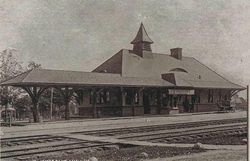
The Village's First Freight and passenger train station was built in 1864, only months after the first train passed through Knowersville. In 1896 the old station was moved south along the tracks. In 1897, it was replaced by the . . . — — Map (db m115732) HM
Cluett, Peabody & Co., a Troy-based manufacturer of men's collars and shirts, purchased Peebles Island in 1909. The abundant water, existing rail lines, and proximity to the company's Troy factory made the island an ideal location for treating . . . — — Map (db m115364) HM
The present day hydroelectric power plant located at this site is owned and operated by the New York
Power Authority. It was constructed in 1908 when the Mohawk River was dammed, the Waterford Flight
of Locks was constructed, and the Erie Canal . . . — — Map (db m138991) HM
This Greek-revival building was one of several weigh stations along the Canal used to levy the tolls for barges carrying merchandise and farm goods.
Until 1850 freight cargoes were measured by the displacement theory, but this hydraulic type . . . — — Map (db m40999) HM
Town Hall
Town of Guilderland
Est. April 4, 1803
First Officers; Supervisor
Nicholas V. Mynderse,
Clerk Peter G. Veeder
Town of Guilderland 1985
— — Map (db m103165) HM
Locust Vale School
New Scotland School
District No. 11. Built about
1827 and closed 1939. Moved
to Meadowdale from Tygert
Road During the 1940's.
— — Map (db m48608) HM
The most obvious music associated with any church is the sweet and dignified tolling of the church bell. Pictured above is George E. Hipwod, President of the Holy Names Society who presented the bell for placement in the new church.
The bell was . . . — — Map (db m70628) HM
Hanging Bog is a man-made pond built by the Civilian Conservation Corps in the 1930's on then federally owned land. In 1962 Hanging Bog was transferred to New York State. The pond is referred to as Hanging Bog because of its unique mat of floating . . . — — Map (db m86561) HM
1933-1942
Allegany State Park - Salamanca, New York
Camp SP-50 - Red House - Company 1250
Camp SP-51 - Red House - Company 249
Camp SP-19 - Red House - Company 2218
Dedicated this 7th day of October 1990 to the memory of those young men . . . — — Map (db m77525) HM
Welcome to Science Lake, a favorite park attraction with an interesting history. Science Lake was built in 1926 as the new location for a science camp popularly called "The School in the Forest." Chauncey J. Hamlin, president of the Buffalo . . . — — Map (db m104901) HM
Sweet Water Spring Legend has it that the Sweet Water Spring gets its name from a Buffalo druggist who was in the area searching for gold with the property owner, N.L. Mr. Kysor. Evidently when the druggist tasted the water, he pronounced it . . . — — Map (db m60092) HM
During the ice ages of the last 2 million years, glaciers sculpted the land surface forming, amongst other features, the many rounded and elongated hills called drumlins that are seen from the Thruway between Rochester and Syracuse. From this . . . — — Map (db m103583) HM
Lock 52 on the Erie Canal was once a busy place. Built in 1851 and lengthened on the berm side in 1887 to accommodate two boats hitched together in tandem, the lock created a popular stopping point for canal boatmen. The 11-foot lift at Lock 52 . . . — — Map (db m103581) HM
The Erie Canal in Port Byron When the original Erie Canal or "Clinton's Ditch" was completed here in 1819, Port Byron was transformed from a frontier settlement to a thriving canal town. Indeed, the local citizens were so hopeful with the new . . . — — Map (db m103580) HM
At the founding of Chautauqua in 1874, John Heyl Vincent assigned to Dr. W.W. Wythe the task of creating Palestine Park, starting with a makeshift temporary wooden model. The park has evolved to its present permanent location and depicts the . . . — — Map (db m117529) HM
First commercial enterprise in southeastern Chautauqua County
Doctor Thomas Ruston Kennedy built first mill October 1805 after purchase of 3000 acres in the area which became the Town of Poland — — Map (db m60146) HM
Newtown Battlefield Preservation has a special place in the history of African Americans' struggle for equality in the United States. When 180 young African-American men of Civilian Conservation Corps (CCC) Company 1251 arrived to work on . . . — — Map (db m90317) HM
Dr. Edwin Eldridge opened
his park in 1879. Called the
beauty spot of the southern
tier for its gardens. Elmira
bought the park in 1889. — — Map (db m77928) HM
The Chenango Land Trust expresses its graditude Maurice and Barbara Ingraham for having the foresight to protect Chenango Canal Lock 99,the best preserved Chenango Canal lock, Lock purchase and preservation made possible by a grant from the Land . . . — — Map (db m93513) HM
Plattsburgh's oldest public
building. Reverend John Henry
Hopkins, who authored the hymn
We Three Kings was the rector
here from 1872-1877.
Le plus ancien batiment publique
de Plattsburgh. Ce fut le Reverend
John Henry Hopkins et . . . — — Map (db m115224) HM
The Harlem Valley derives its name from "The New York and Harlem Railroad," chartered in 1831 and opened in lower Manhattan in 1832 with horse drawn cars. In 1842 the line crossed the Harlem River, and in 1873 joined the New York Central . . . — — Map (db m116811) HM
David Hannum (1822-1891), horse trader and investor in the hoax, "The Cardiff Giant," and on whose life the 1898 novel DAVID HARUM was based, lived in Homer. Portrayed as a horse trader, banker and humanitarian residing in "Homerville," DAVID . . . — — Map (db m141515) HM
Burned rebuilt 1854 3 floor
Seamans Bros owned 1890 to
1920 W F Allen Block burned
1938 built store station
Frost 1985 Antiques 1990 — — Map (db m131028) HM
Dedicated
May 30, 1893,
to the memory
of those who fought
for the preservation
of the Union.
1861 — 1865
Comrades
G.A.R. - F.C. & L. - W.R.C — — Map (db m131032) WM
Presented to
the First Baptist Church
of
Marathon village,
by
Mrs. D. E. Whitmore,
April 23-1901.
————————————
The Carillon of Bells
is dedicated to
the . . . — — Map (db m131022) HM
Made in Marathon, NY by Climax Company,
erected by Sons of Veterans of the Civil War, 1914
Original pole was 110 feet with arrow weather vane.
*Restored and Rededicated September 8, 2007*
Those who unselfishly gave of their time, talent, . . . — — Map (db m131030) HM
The Delaware Valley has been inhabited for thousands of years. At Chestnut Point, and in fields along the West Branch of the Delaware River, more recent local residents have found arrow points, pottery shards, scrapers and other artifacts left . . . — — Map (db m137644) HM
The Largest Community in the valley was Cannonsville, a center of commerce and civic life. Presbyterian Baptist and Methodist Churches served both spiritual and temporal needs. The Cannonsville Community House hosted dances, lectures, and . . . — — Map (db m241779) HM
Named for the signal fires lit by Washington's troops atop our mountain during the American Revolution, Beacon is a city with a rich history dating back 400 years to when Henry Hudson's Half Moon anchored here in this beautiful bay. Beacon . . . — — Map (db m124897) HM
Named for the signal fires lit by Washington's troops atop our mountain during the American Revolution, Beacon is a city with a rich history dating back 400 years to when Henry Hudson's Half Moon anchored here in this beautiful bay. Beacon has . . . — — Map (db m144529) HM
Named for the signal fires lit by Washington's troops atop our mountain during the American Revolution, Beacon is a city with a rich history dating back 400 years to when Henry Hudson's Half Moon anchored here in this beautiful bay. Beacon has . . . — — Map (db m144532) HM
People have mined iron in the Taconic region since the late 1700s. The first iron furnace with a steam-powered bellows was built on this site in 1847. Caleb Maltby purchased the mine in 1861 and the Maltby Iron Company produced a high grade of iron . . . — — Map (db m138098) HM
Conceived in the 1860s, the Poughkeepsie-Highland Railroad Bridge created the only Hudson River crossing between New York City and Albany. Political and financial difficulties prevented the project from getting underway for several years. In 1886, . . . — — Map (db m142777) HM
Walkway Loop Trail
Crossing Walkway Over the Hudson and the Mid-Hudson Bridge, this 3.6-mile loop offers thrilling river views and connects attractions on the Poughkeepsie and Highland waterfronts. It provides a link with 25 miles of rail trails in . . . — — Map (db m37878) HM
Walkway Over the Hudson
A place to enjoy the river and a place to appreciate the wonder of an engineering feat unprecedented in its time with a beauty unsurpassed in our generation.
History
• Completed in 1888, the . . . — — Map (db m37871) HM
A Dam on Tonawanda Creek Tonawanda Creek was the only section of the original Erie Canal that was not man-made. The problem was that the creek level ran 4-½ feet too low. The alleviate this, a wooden dam was constructed in 1823 just west . . . — — Map (db m98569) HM
Extending one mile north from Delaware Park Lake, between Elmwood and Delaware Avenues, the Pan-American Exposition was a spectacular sight to over eight million visitors from May 1 to November 2, 1901. Ornate buildings, embellished with . . . — — Map (db m57079) HM
Early History Converting the mouth of the Buffalo River into a safe and easily navigable harbor was a work of great magnitude and cost. The mouth of the Buffalo River frequently became clogged by sands moving north along the beach towards the . . . — — Map (db m85329) HM
The 1,425-foot south pier as it exists today was built by the Army Corps of Engineers, to strengthen an earlier citizen-built pier that was vital to Buffalo's emergence as a city. In 1820 villagers built a 900-foot pier at this site by placing . . . — — Map (db m84953) HM
In 1987, the New York State Department of State designated the Times Beach area as a significant coastal fish and wildlife habitat. This designation is aimed at protecting the state's most important coastal habitats. Times Beach Nature Preserve is . . . — — Map (db m85308) HM
Nowak Pier in honor of Henry J. Nowak Member of Congress "The Billion Dollar Man" for community service (1966-1992) constructed by U.S. Army Corps of Engineers Buffalo District in cooperation with New York State Departmetn of . . . — — Map (db m97958) HM
• Planning for the Strawberry Island Restoration effort had to take into account the sensitivity of the area in order to avoid negative environmental impacts. • Material added to the island's structure had to be natural-looking, yet still serve . . . — — Map (db m101062) HM
Phase I, The Breach Severe autumn storms in 1992 sped up the erosion of Stawberry Island's southwestern shoreline. In December, the waters of the Niagara River broke through the island and penetrated the lagoon interior. By spring, the . . . — — Map (db m101069) HM
Strawberry Island formed near the end of the Wisconsin Ice Age about 12,000 years ago. When meltwaters broke through gracial till and created the present course of the Niagara River, gravel and sand carried downstream by river currents settled out . . . — — Map (db m101061) HM
You are standing on the bed of the Erie Canal, a 363 mile long, 40 ft. wide, 7 ft. deep "ditich" built from 1817 to 1825 that connected Lake Erie waters with the Hudson River and ultimately the Atlantic Ocean. It unleashed a flood of products, . . . — — Map (db m98540) HM
In 1884, the Tonawanda Gas Light Company was incorporated to supply gas to both Tonawanda and North Tonawanda for street and house lighting. The "gas works" was located on property once owned by Mary Long. Between the Canandaigua and Erie . . . — — Map (db m166212) HM
During the 1800s, many Americans and newly arrived immigrants were eager to move west, but this undertaking proved difficult because of the Appalachian Mountains. A natural barrier running from Alabama through Pennsylvania, New York and on into . . . — — Map (db m77385) HM
An Overview
In the spring of 1823, work on the Erie Canal at this end of the state began with the building of a dam. Its purpose was to raise the water level of Tonawanda Creek 4 to 4 1/2 feet so that its ten-mile stretch between Pendleton . . . — — Map (db m77499) HM
The westernmost leg of the Erie Canal completed in 1825 followed a route paralleling the Niagara River between Tonawanda and Buffalo. From where you are standing, the Canal travelled some ten miles through the mostly unsettled Township of Tonawanda . . . — — Map (db m98556) HM
Dedicated on February 14, 1980 during the XIII Olympic Winter Games to the memory of Norway’s greatest figure skater Sonja Henie (1912-1969). Holder of 10 World Championships, 3 Olympic Gold Medals, the second awarded in Lake Placid at the 1932 . . . — — Map (db m100520) HM
The aerial photograph of Port Henry taken about 1925 leaves no question as to the nature of this place: a busy port shipping the products of its furnaces by water and by rail. Two new furnaces, begun in 1922, represented the latest technology. An . . . — — Map (db m109054) HM
The aerial photograph of Port Henry taken about 1925 leaves no question as to the nature of this place: a busy port shipping the products of its furnaces by water and by rail. Two new furnaces, begun in 1922, represented the latest technology. An . . . — — Map (db m109055) HM
Iron processing changed the shoreline of Port Henry. When the New York and Canada Railroad was built in 1874, the tracks hugged the lake. That same year, a modern blast furnace was built at Cedar Point, just beyond the train station. Eight blast . . . — — Map (db m109053) HM
The Civil War's monstrous appetite for iron - for horse shoes, artillery, cannon balls, rifles, and armor plate - exposed the greatest obstacle to iron production in Moriah: getting ore from the mines to the lake shore. Even 100 teams of horses . . . — — Map (db m109033) HM
This caboose was built in 1946 at Fisher Hill Shop, Mineville N.Y. It is constructed from an iron ore car and weighs 16 tons.
The Lake Champlain and Moriah Railroad used this caboose on the main line from Mineville to Port Henry to haul iron . . . — — Map (db m109056) HM
Powerhouse Park still serves as a staging area for ice fishing shanties during the winter and remains of the old Port Henry Powerhouse form its boundary along Mill Creek.
A mixture of six parts mine tailings to one park concrete was used to . . . — — Map (db m108982) HM
As the idea for a Railroad and Mining Heritage Park took shape in the early 1990s, a few people shared a great dream. Most evidence of Moriah's proud mining heritage had been demolished, but railroad equipment could help people visualize a part of . . . — — Map (db m109040) HM
The first of Port Henry's many iron furnaces was erected just west of here in 1822. Throughout the 19th century new furnaces, crushers, concentrating plants, and casting houses were added to increase production.
The key to the success of Port . . . — — Map (db m108995) HM
Charles M. Spofford, an engineer of the Boston firm Fay, Spofford & Thorndike, designed the 1929 Lake Champlain Bridge. It was the first American highway bridge to employ a continuous truss design to create a curving transition between the deck . . . — — Map (db m109074) HM
Inspired by the 18th-century military gardens Sarah G. T. Pell established the first ornamental garden on this site as the fort was being reconstructed. In 1912 Alfred Bossom, who designed the reconstruction, enclosed the flower garden with a . . . — — Map (db m126315) HM
Inspired by the 18th-century military gardens Sarah G. T. Pell established the first ornamental garden on this site as the fort was being reconstructed. In 1912 Alfred Bossom, who designed the reconstruction, enclosed the flower garden with a . . . — — Map (db m126327) HM
In 1913, Sarah Pell went to Europe looking for artifacts to furnish the King’s Garden and Fort grounds. At a shop in London specializing in historic architectural fragments and antique garden ornaments, she found a set of “leaf work gates of . . . — — Map (db m126312) HM
The grindstones lining this street were used by the early mills operating in the 1800’s.
The mills were located in the entire area of the falls on the La Chute River.
They were salvaged by Vincent Strebe and erected in 1978.
. . . — — Map (db m125100) HM
New York
World War Veterans Memorial Highway
Surveyed 1928 • Completed 1937
During the Administrations of Governors
Alfred E. Smith Franklin D. Roosevelt Herbert H. Lehman
* * * * *
Whiteface Mountain Highway Commission
William . . . — — Map (db m46148) HM
This Side of Street Leveled
On January 21st. Sixteen
Businesses Were Destroyed.
It was an Economic Tragedy,
With No Loss of Life.
Broadalbin Historical Society — — Map (db m75110) HM
Trail Station Park
[Text on the Back]
This Monument Erected 1996 Marks the Site of the Gloversville Passenger Station and Main Offices of the Fonda, Johnstown and Gloversville Railroad It is Dedicated to those who Migrated . . . — — Map (db m68346) HM
New York State purchased Johnson Hall in 1906. At that time, after almost 150 years of changing ownership, only 20 acres remained intact of the original 700+ acre property.
The Johnstown Historical Society, trustee of Johnson Hall in the early . . . — — Map (db m58844) HM
This small dam was built in
1930 to hold back water and
create a permanent lake as
part of the newly created
Sacandaga Reservoir. — — Map (db m190520) HM
Many people in Northville and around Northville know about the return of the Chimney Swifts, but not many people know about Mr. Ray Hubbell. Each year the Chimney Swifts would return to their home in the chimney that was on the corner of 2nd Street . . . — — Map (db m137132) HM
Here the natural water power potential of Old Buttermilk Falls determined not only the village site, but in 1803, the erection of Stoddard and Platt's Pioneer Grist Mill. In 1822 Herman Le Roy, for whom the town was named, replaced this with a much . . . — — Map (db m142118) HM
Zadock Pratt
October 30, 1790 to April 6, 1871
Born in Stephentown, Rensselaer County, New York
Buried in Prattsville, New York Cemetery
Tanner, Farmer, Builder, Banker
U.S. Congressman (1837-1839; 1843-1845)
Wives:
Beda . . . — — Map (db m137374) HM
1885 - 1935
Fire Tower.
The second forest fire
tower in the Adirondacks.
Erected 1909. One of 58 now
maintained by the State in
Adirondacks and Catskills.
New York State Education and
Conservation Departments, . . . — — Map (db m44649) HM
Lake Durant
Named in Honor Of
William West Durant
1850 - 1934
Who Devoted Much of his Life To
Developing the Adirondacks And
Making Known their Beauties
— — Map (db m46723) HM
Home of Gen. Jacob Brown
Commander Northern Frontier
Forces, War of 1812
Commanding General U.S. Army
1821 until his death in 1828
— — Map (db m100639) HM