743 entries match your criteria. The first 100 are listed. ⊳
Mexican-American War Topic
By David J Gaines, October 20, 2012
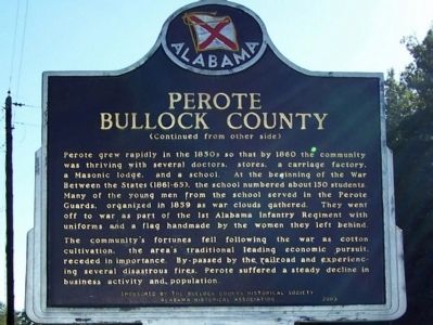
Perote Bullock County Marker, back
| 1 ► Alabama, Bullock County, Perote — Perote Bullock County — |
| On U.S. 15/29, on the right when traveling north. | |||
| 2 ► Alabama, Calhoun County, Jacksonville — William Henry Forney — 1823-1894 — |
| On Public Square East (State Highway 21) south of Clinton Street Southeast, on the left when traveling north. | |||
| 3 ► Alabama, Elmore County, Tallassee — Brigadier General Birkett Davenport Fry, CSA / Tallassee Confederate Officers Quarters — |
| On King Street at North Ann Avenue, on the right when traveling east on King Street. | |||
| 4 ► Alabama, Madison County, Huntsville — Seminole Wars / Mexican War — |
| On Monroe Street Northwest at Washington Street Northwest, on the left when traveling east on Monroe Street Northwest. | |||
| 5 ► Alabama, Marion County, Winfield — Winfield, Alabama — |
| On Bankhead Highway, on the right when traveling west. | |||
| 6 ► Alabama, Montgomery County, Montgomery — Jefferson Davis — June 3, 1808 - December 6, 1889 — Soldier Scholar Statesman — |
| On North Bainbridge Street at Dexter Avenue, on the right when traveling north on North Bainbridge Street. | |||
| 7 ► Alabama, Montgomery County, Montgomery — Lomax House, 1848 — |
| On South Court Street, 0.1 miles Adams Avenue, on the left when traveling south. | |||
| 8 ► Alabama, Montgomery County, Montgomery, Boylston — 167th Infantry / Alabama’s Own — (4th Alabama) — |
| On Johnson Avenue east of Lower Wetumpka Road, in the median. | |||
| 9 ► Alabama, Pickens County, Gordo — History of Gordo, Alabama — |
| On North Main Street (Alabama Route 159) at 2nd Avenue Northwest, on the right when traveling north on North Main Street. | |||
| 10 ► Alabama, Russell County, Fort Mitchell — James Cantey — |
| Near U.S. 165. | |||
| 11 ► Alabama, Tuscaloosa County, Tuscaloosa — Joshua L. Martin — Governor 1845 - 1847 — |
| On 6th Street west of 28th Avenue, on the right. | |||
| 12 ► Alabama, Walker County, Cordova — City Of Cordova — |
| On Mill Street at Main Street, on the right when traveling east on Mill Street. | |||
| 13 ► Alabama, Winston County, Houston — M1841 Mountain Howitzer — |
| On County Road 63 at County Road 61, on the left when traveling south on County Road 63. | |||
| 14 ► Arizona, Cochise County, Benson — Mormon Battalion — LDS Church — |
| On 4th Street (Business U.S. 10) near Ocotillo Avenue, on the right when traveling west. | |||
| 15 ► Arizona, Cochise County, Douglas — Mormon Battalion — LDS Church — |
| On Arizona Route 80 at milepost 356, on the right when traveling east. | |||
| 16 ► Arizona, Cochise County, Douglas — Mormon Battalion — LDS Church — |
| 17 ► Arizona, Cochise County, Douglas — Mormon Battalion — LDS Church — |
| On Geronimo Trail, on the right when traveling east. | |||
| 18 ► Arizona, Cochise County, Douglas — Mormon Battalion — |
| On Geronimo Trail, on the right when traveling east. | |||
| 19 ► Arizona, Cochise County, Palominas — Mormon Battalion — |
| Near Arizona Route 92 at milepost 340. | |||
| 20 ► Arizona, Cochise County, Sierra Vista — Mormon Battalion — LDS Church — |
| On East Charleston Road, on the right when traveling east. | |||
| 21 ► Arizona, Cochise County, Sierra Vista — Mormon Battalion Campsite — |
| On Arizona Route 90 at milepost 329, on the left when traveling east. | |||
| 22 ► Arizona, Cochise County, St. David — Mormon Battalion — LDS Church — |
| On West Patton Street (Arizona Route 80 at milepost 301) at South Church Street, on the right when traveling east on West Patton Street. | |||
| 23 ► Arizona, Gila County, Globe — El Capitan Pass — |
| On Arizona Route 77 at milepost 162, on the right when traveling north. | |||
| 24 ► Arizona, Graham County, Safford — Army of the West — |
| On U.S. 70 at milepost 347, on the left when traveling east. | |||
| 25 ► Arizona, Mohave County, Kingman — Lt. Edward Fitzgerald Beale — 1822 - 1893 — |
| Near Andy Devine Road (Business Interstate 40) near Grandview Avenue. | |||
| 26 ► Arizona, Pima County, Tucson, Armory Park — To The Mormon Battalion — |
| On South 6th Avenue, on the right when traveling north. | |||
| 27 ► Arizona, Pima County, Tucson, Downtown — Exchange at the Presidio — The Mormon Battalion Enters Tucson, 16 December 1846 — |
| Near West Alameda Street. | |||
| 28 ► Arizona, Pinal County, Casa Grande — In Honor of Mormon Battalion — |
| On North Pinal Avenue, on the right when traveling south. | |||
| 29 ► Arizona, Pinal County, Gila River — Gadsden Purchase — |
| Near Interstate 10 at milepost 183. | |||
| 30 ► Arizona, Pinal county, Gila River — Gadsden Purchase — |
| Near Interstate 10 at milepost 181. | |||
| 31 ► Arizona, Pinal County, Kearny — Kearny, Arizona — Named in Honor of Stephen Watts Kearny — Brevet Major General U.S. Army — |
| On Alden Road north of Upton Road, on the right when traveling east. | |||
| 32 ► Arizona, Pinal County, Picacho — 71 — Mormon Battalion Trail — |
| Near Interstate 10. | |||
| 33 ► Arizona, Yuma County, Roll — Antelope Hill Campsite — |
| Near County 8th Street, 0.3 miles east of Mohawk Valley Road. | |||
| 34 ► Arizona, Yuma County, Roll — Antelope Hill Campsite — |
| Near County 8th Street, 0.3 miles east of Mohawk Valley Road. | |||
| 35 ► Arizona, Yuma County, Yuma — Mormon Battalion Crossing / Colorado River Crossing — |
| Near West 8th Street, 0.5 miles west of Somerton Avenue. | |||
| 36 ► Arizona, Yuma County, Yuma — U.S. Army of the West — Mormon Battalion — Longest Sustained March in U.S. Military History, 1846-1847 — |
| Near 12th Avenue, 0.8 miles west of Water Street. | |||
| 37 ► Arkansas, Benton County, Bella Vista — Mexican War — |
| 38 ► Arkansas, Benton County, Bella Vista — United States Commanders in Chief — |
| 39 ► Arkansas, Benton County, Bella Vista — United States Commanders in Chief — |
| 40 ► Arkansas, Columbia County, Magnolia — 24 — Gen. John Porter McCown — |
| Near South Washington Street at East Ross Street, on the right when traveling south. | |||
| 41 ► Arkansas, Crawford County, Van Buren — Crawford County War Memorial — |
| On South 4th Street at Webster Street, on the left when traveling north on South 4th Street. | |||
| 42 ► Arkansas, Crittenden County, Marion — Military Road — |
| Near Arkansas Route 77 north of East Military Road, on the right when traveling south. | |||
| 43 ► Arkansas, Pulaski County, Little Rock, Downtown — Mexican-American War Memorial — |
| Near West Markham Street at Ashley Street, on the right when traveling west. | |||
| 44 ► Arkansas, Washington County, Fayetteville — Archibald Yell — In Memory Of — |
| On College Avenue (U.S. 71) at Center Street, on the right when traveling north on College Avenue. | |||
| 45 ► Arkansas, Washington County, Fayetteville — 39 — Archibald Yell — Second Governor of Arkansas — |
| 46 ► California, Alameda County, Oakland — In Memory of Col. John Coffee Hays — 1-28-1817 • 4-21-1883 — |
| Near Piedmont Avenue, 0.3 miles east of Pleasant Valley Avenue. | |||
| 47 ► California, Alameda County, Pleasanton — 510 — Francisco Solano Alviso Adobe |
| Near Foothill Rd, 0.8 miles south of Old Foothill Rd.. Reported missing. | |||
| 48 ► California, Calaveras County, Murphys — Maj. James D. Savage — |
| Near Main Street. | |||
| 49 ► California, El Dorado County, Coloma — Changing California — |
| Near Coloma Road (California Route 49) north of Mt Murphy Road. | |||
| 50 ► California, El Dorado County, Coloma — Mormon Cabin — Replica |
| Near State Highway 49. Reported permanently removed. | |||
| 51 ► California, El Dorado County, Coloma — Mormon Workers Cabin — |
| Near Coloma Road (California Route 49) north of Mt Murphy Road. | |||
| 52 ► California, Fresno County, Fresno — 28 — John Charles Fremont — |
| Near West Kearney Boulevard, 0.3 miles west of South Bryan Avenue. | |||
| 53 ► California, Imperial County, El Centro — 1 — Mormon Battalion — |
| On Kumeyaay Highway (Interstate 8) west of Silsbee Road, on the right when traveling west. | |||
| 54 ► California, Kern County, Bakersfield — 732 — Home of Elisha Stevens — |
| On West Columbus Street at Isla Verde Street, on the right when traveling west on West Columbus Street. | |||
| 55 ► California, Kern County, Bakersfield — 690 — Last Home of Alexis Godey |
| Near R Street north of 19th Street. Reported missing. | |||
| 56 ► California, Los Angeles County, Compton — 152 — Domínguez Ranch House — |
| On South Alameda Street, on the right when traveling north. | |||
| 57 ► California, Los Angeles County, Duarte — Andres Avelino Duarte — 1805-1863 — |
| On Huntington Drive at Calle Andres, on the right when traveling west on Huntington Drive. | |||
| 58 ► California, Los Angeles County, Glendale, Tropico — Glendale Station Clock — Oak of Peace — |
| Near West Cerritos Avenue at El Bonito Avenue. | |||
| 59 ► California, Los Angeles County, Glendale, Verdugo Woodlands — 2 — Oak of Peace — |
| Near Bonita Drive south of Opechee Way, on the right when traveling south. | |||
| 60 ► California, Los Angeles County, Glendale, Verdugo Woodlands — 637 — San Rafael Rancho — Catalina Verdugo Adobe — Oak of Peace — |
| Near Bonita Drive south of Opechee Way, on the right when traveling south. | |||
| 61 ► California, Los Angeles County, Los Angeles, Downtown Los Angeles — Fort Moore — Pioneer Memorial and Park — |
| On North Hill Street, on the right when traveling north. | |||
| 62 ► California, Los Angeles County, Los Angeles, Downtown Los Angeles — Headquarters of Commander Robert Field Stockton — Avila Adobe — |
| Near Olvera Street north of Paseo De La Plaza, on the right when traveling north. | |||
| 63 ► California, Los Angeles County, Los Angeles, Hollywood Hills — 181 — Lankershim Monument — |
| Near Nichols Canyon Road near Chandelle Road. | |||
| 64 ► California, Los Angeles County, Los Angeles, San Pedro — 515 — Battery Osgood-Farley Historic Site — Home of the Fort MacArthur Museum — Battle Honors, Third Coast Artillery — |
| Near Leavenworth Drive west of South Gaffey Street, on the left when traveling west. | |||
| 65 ► California, Los Angeles County, Los Angeles, Studio City — 151 — Campo de Cahuenga — Original Adobe — |
| Near Lankershim Boulevard, 0.1 miles north of the Hollywood Freeway (U.S. 101), on the left when traveling north. | |||
| 66 ► California, Los Angeles County, Pasadena — The Picture Bridge — Huntington Hotel — |
| Near Oak Knoll Avenue at Hillcrest Avenue, on the right when traveling south. | |||
| 67 ► California, Los Angeles County, South Montebello — 385 — Battle of the Rio San Gabriel — |
| On Bluff Road north of Washington Boulevard, on the right when traveling north. | |||
| 68 ► California, Los Angeles County, South Pasadena — Adobe Flores — |
| On Foothill Street west of Garfield Avenue, on the right when traveling west. | |||
| 69 ► California, Los Angeles County, Vernon — 167 — La Mesa Battlefield — |
| Near South Santa Fe Avenue, on the right when traveling south. | |||
| 70 ► California, Los Angeles County, Vernon — 167 — The Battle of La Mesa — La Batalla de La Mesa — January 9th, 1847 — |
| On S. Santa Fe Avenue at E. Vernon Avenue, on the right when traveling south on S. Santa Fe Avenue. | |||
| 71 ► California, Monterey County, Monterey — 1 — Custom House — |
| On Olivier Street. | |||
| 72 ► California, Monterey County, Monterey — Larkin House — |
| On Calle Principal at Jefferson Street Monterey, on the left when traveling south. | |||
| 73 ► California, Monterey County, Monterey — 1 — Monterey Custom House — |
| Near Lighthouse Avenue. | |||
| 74 ► California, Monterey County, Monterey — Monterey Harbor — |
| On Monterey Bay Coastal Trail. | |||
| 75 ► California, Monterey County, Monterey — Quarters of General William Tecumseh Sherman — |
| On Calle Principal at Jefferson Street, on the left when traveling north on Calle Principal. | |||
| 76 ► California, Monterey County, Monterey — Site of Original Flagstaff — |
| Near Monterey Peninsula Recreational Trail. | |||
| 77 ► California, Monterey County, Monterey — Sloat Monument — |
| Near Corporal Ewing Road. | |||
| 78 ► California, Monterey County, Monterey — Sloat's Landing — |
| Near Olivier Street. | |||
| 79 ► California, Monterey County, Prunedale — 651 — Battle of Natividad — |
| On San Juan Grade Road at Crazy Horse Canyon Road on San Juan Grade Road. | |||
| 80 ► California, Napa County, Calistoga — 359 — Dr. Edward Turner Bale — |
| Near Saint Helena Highway (State Highway 29/128). | |||
| 81 ► California, Napa County, Napa — Fremont's Crossing — |
| On Main Street north of Third Street, on the left when traveling south. | |||
| 82 ► California, Orange County, Orange — John C. Fremont Camp — |
| On Chapman Avenue at Marks Way, on the right when traveling west on Chapman Avenue. | |||
| 83 ► California, Orange County, Yorba Linda — Yorba Linda — |
| On Lemon Drive at Main Street, on the right when traveling east on Lemon Drive. | |||
| 84 ► California, Riverside County, Aguanga — U.S. Mormon Battalion Trail — 1847 — Temecula Valley — |
| On California 79, 1.5 miles south of Sage Road, on the right when traveling south. | |||
| 85 ► California, Sacramento County, Elk Grove — 680 — Murphy’s Corral — |
| On West Stockton Boulevard east of Promenade Parkway, on the left when traveling east. | |||
| 86 ► California, Sacramento County, Sacramento, Southwestern Sacramento — General George Wright — 1803 – 1865 — |
| 87 ► California, Sacramento County, Sacramento, Southwestern Sacramento — 566 — Sacramento City Cemetery — |
| Near Broadway. | |||
| 88 ► California, San Benito County, San Juan Bautista — 181 — Fremont Peak — ← 11 Miles — |
| On Muckelemi Street, on the left when traveling west. | |||
| 89 ► California, San Bernardino County, Baker — The Desert Studies Center — Zzyzx — |
| On Zzyzx Road, 5 miles south of Interstate 15, on the left when traveling south. | |||
| 90 ► California, San Bernardino County, Barstow — General Steven Watts Kearny — 1794-1848 — |
| On East Main Street (Business Interstate 15), on the right when traveling east. | |||
| 91 ► California, San Bernardino County, Chino — 942 — Rancho Chino Adobe Site — |
| On Eucalyptus Avenue near Pipeline Avenue, on the right when traveling west. | |||
| 92 ► California, San Bernardino County, Chino — Site of the Battle of Chino — |
| On Eucalyptus Avenue near Pipeline Avenue, on the right when traveling west. | |||
| 93 ► California, San Bernardino County, San Bernardino — Historic Cannon — |
| On Del Rosa Avenue North at Date Place, on the left when traveling south on Del Rosa Avenue North. | |||
| 94 ► California, San Bernardino County, Victorville — 150 — Lane's Crossing — |
| On Turner Road, 1 mile west of National Trails Highway, on the left when traveling west. | |||
| 95 ► California, San Diego County, Camp Pendleton South — Leonardo Cota and Jose Alipas — |
| Near Vandegrift Boulevard. | |||
| 96 ► California, San Diego County, Escondido — An Incident of the Mexican War — |
| 97 ► California, San Diego County, Escondido — San Pasqual — |
| On San Pasqual Valley Road (California Route 78), on the right when traveling west. | |||
| 98 ► California, San Diego County, Escondido — 533 — San Pasqual Battlefield — |
| On San Pasqual Valley Road (California Route 78 at milepost 25.1), on the right when traveling west. | |||
| 99 ► California, San Diego County, San Diego — 63 — First Raising of U.S. Flag — Plaza San Diego Viejo — |
| Near Mason Street north of San Diego Avenue, on the left when traveling north. | |||
| 100 ► California, San Diego County, San Diego — 55 — Fort Rosecrans National Cemetery — |
| Near Cabrillo Memorial Drive (State Highway 209), on the right when traveling south. | |||
743 entries matched your criteria. The first 100 are listed above. Next 100 ⊳