On South Broad Street at Eaton Ave. on South Broad Street.
Canal bridge site where 1,000 men of the 114th Regt. embarked by flotilla to Civil War, Sept. 6, 1862.
Bicentennial '76
NB&T of Norwich — — Map (db m92593) HM
On New York State Route 12, on the right when traveling north.
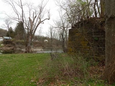
East of the road are remains of a lock and feeder pond where canal passed through productive farm country.
Bicentennial '76
Terry Descendants — — Map (db m92595) HM
On Lackawanna Avenue, on the left when traveling west.
This view of the Chenango Canal is looking north toward the Maydole Hammer factory and Lock #93. The Hammer factory covered the area today (2007) occupied by the buildings of the Golden Age Apartments. The lock was located in the space that is now . . . — — Map (db m94231) HM
On Lackawanna Avenue, on the left when traveling west.
This photograph taken from the west bank of the Chenango Canal looking east, shows the Sternberg, Hall and Company Sash and Blind Factory. The picture of the factory was taken about 1872. The factory produced window frames (sashes) and blinds . . . — — Map (db m94233) HM
On Canal Street, on the left when traveling south.
This photograph taken about 1870 shows the Chenango Canal looking south from the viewpoint of the canal bridge that crossed East Main Street at Canal Street. In the foreground is Edwin Smith's Warehouse, later known as R.D.Eaton Grain and Seed . . . — — Map (db m94236) HM
The Chenango Land Trust expresses its graditude Maurice and Barbara Ingraham for having the foresight to protect Chenango Canal Lock 99,the best preserved Chenango Canal lock, Lock purchase and preservation made possible by a grant from the Land . . . — — Map (db m93513) HM
Near Mace Chasm Road at U.S. 9, on the left when traveling west.
When Ausable Chasm opened to the public in 1870, access was limited to a couple of places, one being Table Rock from the Chasm rim via a long steep staircase. This changed in 1873 when Philadelphia entrepreneurs acquired lands along the Chasm's . . . — — Map (db m160734) HM
Near Mace Chasm Road at U.S. 9, on the left when traveling west.
Each boat, and each boatman paining, made many trips down the Chasm a day (often 10-20). Getting 1-to 2-ton boats back upriver 1 mile (16 km) from the Boat Landing to Table Rock for another ride posed quite the challenge. So how was this done? . . . — — Map (db m160736) HM
Near Mace Chasm Road at U.S. 9, on the left when traveling west.
Seneca R Stoddard, eminent Adirondacks photographer and guidebook author, penned these words about the Ausable Chasm (Kaz' m] Best Ride in 1890—
"Through a cleft in the lower edge of Table Rock we descend and enter the large bateaux . . . — — Map (db m160733) HM
On Mace Chasm Road near U.S. 9, on the left when traveling west.
The boat displayed here belonged to the last fleet of wooden boats used for the highly popular scenic boat tour of Ausable Chasm [Aw-SAY-bull Kaz-'m], enjoyed by millions of people since it began in 1873. Then—as now—the boat tour . . . — — Map (db m160731) HM
On Lake Shore Road north of Miner Farm Road, on the left when traveling north.
Near this spot survivors of the British gunboat Simcoe buried their dead comrades left on board following the American naval victory on Plattsburgh Bay. — — Map (db m105855) HM
On New York State Route 22B at Kent Falls Road (County Route 31), on the right when traveling south on State Route 22B.
The sites of the three NYSEG power plants located in this area of Saranac River were pulp mills. Mill B was built in 1880. Mills C and D were constructed in 1891. The mills were in operation until 1927, after which they were
converted to . . . — — Map (db m194604) HM
On U.S. 9 at Ausable Point Road, on the right when traveling north on U.S. 9.
( left panel )
Lakes to Locks Passage takes you through
a spectacular landscape laden with history.
Follow this map to find your way through
four story-filled regions that connect the
historic waters of Lake Champlain and . . . — — Map (db m194631) HM
On Cumberland Head Road, on the left when traveling south.
This was the scene in Cumberland Bay on September 11, 1814. An American Fleet under the command of U. S. Navy Lieutenant Thomas Macdonough defeated the British and changed the course of history.
Macdonough anchored his fleet and awaited the . . . — — Map (db m177282) HM
Near Hamilton Street close to Club Road, on the right when traveling east.
Throughout the War of 1812, British forces targeted Lake Champlain as an invasion route. United States Navy Lieutenant Thomas Macdonough was able to confine them in the Richelieu River of Quebec throughout the summer of 1813. American shipbuilders . . . — — Map (db m48447) HM
On Lake Street (New York State Route 9B) at U.S. 11, on the right when traveling north on Lake Street.
Near Site of David Mayo's sail ferry, 1805. Crossed Lake Champlain from the foot of Champlain St. to Windmill Point, Alburgh, VT. — — Map (db m234758) HM
On Montgomery Street, on the right when traveling east.
This Barge Canal Terminal Dock, built in 1916, represents the last chapter in a lively history of shipping improvements that connected Rouses Point with Canada, New York City and Buffalo through Lake Champlain. Shipping on the lake meant living on . . . — — Map (db m175646) HM
On New York State Route 9 north of Lapham Mills Road, on the right when traveling north.
Est. by Robt. Platt ca. 1820
This busy Lake Champlain port
was an important transportation
hub for both people and goods
during the 1800's. — — Map (db m108681) HM
On New York State Route 9 at Old Dock Road, on the left when traveling south on State Route 9.
2000 acres settled in 1766 by William Gilliland (1734-1796) first named Janesborough, later Port Gilliland. A port for lake shipped goods c. 1820-1900. — — Map (db m108643) HM
On U.S. 9, 0.1 miles north of Commons Road (County Route 6), on the left when traveling north.
Since and prior to its incorporation in 1788, Clermont has played a significant role in the history of America. Clermont’s history includes: home of Robert R. Livingston, negotiator of Louisiana Purchase and a drafter of the Declaration of . . . — — Map (db m136305) HM
Near Clermont Avenue, 0.3 miles west of Woods Road (County Route 35).
For most of Clermont's history, a dock has been located along the property's Hudson River shoreline.
Before the advent of railroads and highways, when passengers and freight traveled primarily by ship,
the dock provided an essential connection . . . — — Map (db m149809) HM
In his fantastical tale, Rip Van Winkle, Washington Irving told of how the ghosts of Captain Henry Hudson and his crew appeared once every twenty years in the Catskill mountains, across the river from here. According to the story, the . . . — — Map (db m130614) HM
Near Albany-Hudson Electric Trail south of Little Lake Road, on the left when traveling south.
The Hudson River Valley was colonized by Dutch settlers in the first half of the 1600s. The stream in front of you - the Valatie Kill - draws its name, pronounced "vah-lay-sha," from the Dutch words "vaal" (falls), "je" (little), and "kill" (stream . . . — — Map (db m230280) HM
On Hudson Avenue (County Route 25A), on the left when traveling south.
Prior to 1667 known as “Major Abram’s (Staats) Kill” and “Third Falls.” In 1823 called Stuyvesant Falls” and after 1845 “Kinderhook Creek” — — Map (db m56638) HM
Near Albany-Hudson Electric Trail, 1.2 miles north of Main Street, on the right when traveling north.
The Hudson River Valley was colonized by Dutch settlers in the first half of the 1600s. The stream in front of you - the Valatie Kill - draws its name, pronounced "vah-lay-sha," from the Dutch words "vaal" (falls), "je" (little), and "kill" (stream . . . — — Map (db m230194) HM
On Port Watson Street (U.S. 11), on the right when traveling west.
Port Watson
Founded by Elkanah Watson
About 1805. Mills, Brewery
Rope Walk. Sent Arks, Rafts
Cargoes to Penna. Absorbed
By Cortland in 1867
— — Map (db m25425) HM
On New York State Route 10 at Basin Clove Road on State Route 10.
Side A
Hamden Covered Bridge Built in 1859 and placed on the state and national registers of historic places in 1999. Side B
Built in 1859 by Robert Murray to span 128' of the west branch at a cost of $1,000. Restored in 2000 . . . — — Map (db m93306) HM
On Main Street (New York State Route 30) just east of Fair Street, on the right when traveling east.
While the Flood Buy-Out Program allowed many families to relocate out of the floodway, it also permanently changed the community.
More than six acres of land in the heart of Margaretville, mostly on Main Street, became vacant. Local residents . . . — — Map (db m147303) HM
On Main Street (New York State Route 30) just east of Fair Street, on the right when traveling east.
The cost of the Flood of '96 was high. Ten people died in the Catskills. Dozens lost their homes. The lives of thousands more were disrupted for months. Across Delaware County, the State and Federal governments paid more than $20 million in . . . — — Map (db m147368) HM
Th East Branch of the Delaware of and its many tributaries- - the Binnekill, Bush Kill, Plattekill, Mill Brook, Dry Brook, Bull Run, Batavia Kill, Red Kill and others
are central to the history of the Village of Margaretville and the wider Town . . . — — Map (db m132228) HM
This stream-crossed valley beneath 3,200-foot Pakatakan Mountain has been attracting travelers since the Lenni Lenape found good hunting and fishing here hundreds of years ago. The first European settlers arrived in the region in 1763, and a small . . . — — Map (db m132158) HM
Near River Street north of Dunham Street, on the right when traveling west.
An unusual combination of heavy snowpack, high winds, unseasonably warm temperatures, heavy rainfall, and ice jams resulted in a basin wide flash flood in the Susquehanna River Basin from January 19-21, 1996. The heavy accumulation of snow from . . . — — Map (db m220630) HM
Near River Street at Dunham Street, on the right when traveling west.
The Susquehanna, one of the most beautiful rivers in America, was named by the Algonquin Sasquesahanock Indians who long ago lived on it's banks. Rising out of Otsego Lake, the river flows generally south through New York, Pennsylvania, and . . . — — Map (db m220623) HM
Near River Street near Dunham Street, on the right when traveling west.
The life cycle in the Susquehanna River begins with bacteria,
which are nurtured by organic materials in the water.
Microscopic water plants called algae use substances formed
by bacteria and replenish the oxygen supply. Protozoa eat
algae and . . . — — Map (db m220626) HM
On Route 10 (New York State Route 10) near Taylor Road (County Route 45) when traveling north. Reported missing.
Named after Indian maiden famous in Indian legend on trail from Schoharie to Delaware and Susquehanna Rivers. Headwaters of Del. — — Map (db m205910) HM
On Vanderbilt Park Road, on the left when traveling north.
Four men built houses atop this bluff to command panoramic views of the Hudson River: Samuel Bard (1799), Dr. David Hosack (1829), Walter Langdon (1847), and Frederick Vanderbilt (1898). All maintained overlooks at this site just north of their . . . — — Map (db m210516) HM
Near Albany Post Road (U.S. 9) at FDR Drive, on the left when traveling north.
All that is within me cries to go back to my home by the Hudson River. - Franklin D. Roosevelt, 1944
It was only when passing through the gates at the end of this road that FDR felt truly at home. Roosevelt loved Springwood’s forests and . . . — — Map (db m83113) HM
STARTING AT THE RIVER'S EDGE
Many Hudson River settlements share similar beginnings. The Hudson has been the lifeblood of the Valley since before history, providing food, water and transport. The Hudson is a tidal estuary — an arm of the . . . — — Map (db m210494) HM
On River Street, on the right when traveling south.
The Hyde Park Ice Yacht Club, had its boathouse on lands now owned by Hyde Park Landing. Members were united by a shared passion for their river and their sport, particularly racing. FDR (before his presidential days), FW Vanderbilt, Archibald . . . — — Map (db m210410) HM
A view of Hyde Park Landing from the Professions and Industries in Hyde Park murals in the Hyde Park, New York Post Office painted in 1941 by Olin Dows (1904-1981). Dows, a Rhinebeck native and Vassar-trained artist, became head of . . . — — Map (db m210401) HM
A view of Hyde Park Landing from the Professions and Industries in Hyde Park murals in the Hyde Park, New York Post Office painted in 1941 by Olin Dows (1904-1981). Dows, a Rhinebeck native and Vassar-trained artist, became head of . . . — — Map (db m210491) HM
Sturgeon: This fish once abounded in the Hudson River. It was a favorite of the Dutch, at Albany (Beverwyck), and is on that account, called "Albany Beef".
Mr. Lehan lived on River Road at the top of the hill south of Hyde Park Landing. He . . . — — Map (db m210408) HM
Near Parker Avenue (New York State Route 9G) 0.2 miles east of Washington Street (New York State Route 9G), on the left when traveling east.
In 1992, Walkway Over the Hudson was established to preserve the Poughkeepsie-Highland Railroad Bridge, transform it into a linear park and trailway and provide long-term stewardship. With public and private support, the bridge-to-park . . . — — Map (db m142779) HM
Near Parker Avenue (New York State Route 9G) 0.2 miles east of Washington Street (New York State Route 9G), on the left when traveling east.
The Intercollegiate Rowing Association held the National Championship at Poughkeepsie in 1895 and almost every year thereafter until 1949.
Background photo courtesy Library of Congress. — — Map (db m145006) HM
Near Parker Avenue (New York State Route 9G) 0.2 miles east of Washington Street (New York State Route 9G), on the left when traveling east.
The Dutch named the Hudson from Crum Elbow (4 miles to the north) to Danskammer Point (9 miles to the south) Lange Rack, which means long reach, because sloop skippers did not have to change the set of their sails on that long, straight . . . — — Map (db m145250) HM
Near Parker Avenue (New York State Route 9G) 0.2 miles east of Washington Street (New York State Route 9G), on the left when traveling east.
During the late 1800s, Poughkeepsie’s waterfront south of the bridge was lined with factories and warehouses, including the Vassar Brewery and Foster Lumber Yard. The Main Street ferry landing is right of center.
Background photograph . . . — — Map (db m145300) HM
Near Parker Avenue (New York State Route 9G) 0.2 miles east of Washington Street (New York State Route 9G), on the left when traveling east.
The river is named for Englishman Henry Hudson, who explored it aboard the Half Moon in 1609. He was searching for an all-water route to Asia for the Dutch East India Company. It was also called the “North River” by the Dutch. . . . — — Map (db m145000) HM
Near Parker Avenue (New York State Route 9G) 0.2 miles east of Washington Street (New York State Route 9G), on the right when traveling east.
In 1807, Robert Fulton and Robert R. Livingston, Jr. successfully operated the North River Steamboat of Clermont between New York City and Albany, heralding the beginning of steam navigation on the Hudson.
Background illustration . . . — — Map (db m145009) HM
On North Water Street, 0.2 miles north of Main Street, on the right when traveling north.
Long before locomotives and automobiles, the Hudson River was like a super highway attracting intrepid explorers, settlers, and businessmen. As such, the area's earliest economic development dotted the lush banks of the waterfront. This is where . . . — — Map (db m140324) HM
The Poughkeepsie-Highland Bridge is the oldest surviving steel cantilever bridge in the world, and when built, had the longest truss and cantilever spans. The bridge provided the first, and only, all-rail route across the Husdon River south of . . . — — Map (db m35483) HM
Near Rinaldi Blvd. at Pine Street, on the right when traveling south.
This plaque is a tribute to over 100 yeas of Ship Building in Poughkeepsie, officially begun when the Continental Congress authorized construction of the two frigates Congress and Montgomery on Dec. 13, 1775. Additionally, fire rafts (1776), . . . — — Map (db m199564) HM
Near Parker Avenue (New York State Route 9G) 0.2 miles east of Washington Street (New York State Route 9G), on the left when traveling east.
Poughkeepsie's steamboat and ferry landing at the foot of Main Street (now Victor C. Waryas Park) was a bustling transportation hub. The horse-drawn trolleys are an early instance of public transportation.
Background photo from the B.L. . . . — — Map (db m145007) HM
Near Parker Avenue (New York State Route 9G) 0.2 miles east of Washington Street (New York State Route 9G), on the left when traveling east.
The Clearwater replicates the mid-19th-century sloops that plied the Hudson River. Folk singer and river champion Pete Seeger launched the ship as a tool for environmental education and advocacy in 1969.
Background photograph by Brian A. . . . — — Map (db m145297) HM
Near Parker Avenue (New York State Route 9G) 0.2 miles east of Washington Street (New York State Route 9G), on the left when traveling east.
A tributary of the Hudson River, the Fall Kill supplied water power to Poughkeepsie's 18th - and 19th - century industries, including mills, cloth production, a brewery, and a carpet factory.
Background photograph courtesy of Linda T. . . . — — Map (db m145294) HM
Near Parker Avenue (New York State Route 9G) 0.2 miles east of Washington Street (New York State Route 9G), on the left when traveling east.
The Hudson River Day Line steamer Albany glides under the bridge in 1894. The steamboat company provided regularly scheduled passenger service between New York City and Albany from 1863 to 1948.
Background photograph courtesy . . . — — Map (db m145245) HM
Near Parker Avenue (New York State Route 9G) 0.2 miles east of Washington Street (New York State Route 9G), on the left when traveling east.
Whale oil was widely used in lamps during the early 1800s. The Poughkeepsie Whaling Company, formed in 1831, was one of several ocean-going fleets operating along the Hudson. It closed in 1843 when using kerosene in lamps increased. . . . — — Map (db m145012) HM
Near Parker Avenue (New York State Route 9G) 0.2 miles east of Washington Street (New York State Route 9G), on the left when traveling east.
Although the river dates back some 60 million years, the river we see today was shaped during the last Ice Age. About 16,000 years ago, a massive ice field gouged the riverbed to a depth below sea level, thus allowing water from the Atlantic Ocean . . . — — Map (db m142780) HM
Near County Road 85, on the left when traveling east.
You are looking at the site of Wilderstein's boathouse (pictured above) and the Ellerslie dock (formerly Lewis Landing) owned by Governor Morton. In 1888 Arnout Cannon Jr., an architect from Poughkeepsie, NY, designed the boathouse for Robert . . . — — Map (db m35437) HM
On Old Post Road, 0.3 miles west of Albany Post Road (U.S. 9), on the right when traveling west.
Some 12,000 years ago, after the glaciers receded and melt waters carved out water courses, a forested river valley formed here. In 1609 Henry Hudson sailed up the Muhheakantuk ("The River that Flows Two Ways") and met the local Algonquian-speaking . . . — — Map (db m146974) HM
Near Creekside Drive, 0.1 miles west of Old Niagara Falls Boulevard.
A Dam on Tonawanda Creek Tonawanda Creek was the only section of the original Erie Canal that was not man-made. The problem was that the creek level ran 4-½ feet too low. The alleviate this, a wooden dam was constructed in 1823 just west . . . — — Map (db m98569) HM
On Tonawanda Creek Road at New Road, on the right when traveling west on Tonawanda Creek Road.
During more than 175 years of existence, the Erie Canal has followed more than one path. In some places, two or three generations of Canal infrastructure still exist side by side. When technology, especially mechanized boats, made it possible for . . . — — Map (db m94637) HM
On New York State Thruway / AMVETS Memorial Highway (Interstate 90 at milepost 443).
Following La Salle's arrival at the Niagara River in 1678, that waterway between Lakes Erie and Ontario became a natural route to and from the river during the 18th century. Permanent settlement of the Western New York began in 1800 following the . . . — — Map (db m24593) HM
On Davis Road (New York State Route 240) at Bridge Street, on the left when traveling south on Davis Road.
Throughout the history of the area, Cazenovia Creek has played a vital role in the industry and natural beauty of the Town of Aurora and the Southtowns. Connecting the Town. Aurora, as it is today, would not have existed in the same form had . . . — — Map (db m104158) HM
On Black Rock Harbor Road, 0.2 miles west of Niagara Street (New York State Route 266), on the left when traveling west. Reported missing.
The black rock that gave this area its name was located in the Niagara River at the bend of the present day Niagara Street, near School Street, north of where the Peace Bridge is now situated. Comprised of Onondaga limestone, the rock ledge jutted . . . — — Map (db m98187) HM
On Robert Rich Way, 0.1 miles south of Ferry Street Bridge, on the right when traveling south.
[left panel] Black Rock Harbor. The Village of Black Rock received its name from a large rock outcropping that jutted into the river about a half mile south of this site. The original ferry crossing was located at the rock and a small village grew . . . — — Map (db m97956) HM
On Robert Rich Way, 0.1 miles south of Ferry Street Bridge, on the right when traveling south.
Freedom Seekers faced daunting odds and demonstrated remarkable courage. Most started their journeys with little knowledge of what lay before them, and many sought help from free blacks and sympathetic whites once they reached the north. . . . — — Map (db m97931) HM
On Robert Rich Way at West Ferry Bascule Bridge when traveling west on Robert Rich Way.
Black Rock developed dramatically in the 19th century due to the Erie Canal and its competing railroads. Mills, factories, and an array of manufacturing plants were constructed along the waterfront with immigrant neighborhoods and commerical areas . . . — — Map (db m98194) HM
On Robert Rich Way at West Ferry Bascule Bridge when traveling west on Robert Rich Way.
The Black Rock Ferry was an important crossing to Canada throughout the 19th century until it ceased operations in 1949. The ferry wharf was located on a long, narrow stone pier constructed to protect Black Rock Harbor from the Niagara River. . . . — — Map (db m98196) HM
Fitting the Ships of War at the Scajaquada Creek Boat Yard In the early 1800s, the United States being a country of less than 50 years, began to recognize the need to have military transport routes to connect and supply its forts. The waterways . . . — — Map (db m236060) HM
On Erie Street, 0.2 miles west of Marine Drive, on the left when traveling north.
John Maynard
“Who is John Maynard?”
“John Maynard, he was our helmsman
Who held out ’till he brought us safely through,
Saved us and wears a hero’s crown above.
For us he died, and his reward our love.
John . . . — — Map (db m92930) HM
The Niagara River Historic Events: War of 1812 Approximately 2000 feet northwest from this spot, in the Niagara River, lies the remains of a (War of 1812) battleship. The vessel was identified as the U.S.S. Adams, also known as the H.M.S. . . . — — Map (db m140671) HM
On Robert Rich Way at Ferry Street Bridge, on the right when traveling south on Robert Rich Way.
From this site and from other places along the Niagara River escaping slaves were conducted across the boundary from the United States to freedom in Canada. — — Map (db m97933) HM
On Amherst Street at Niagara Street (New York State Route 266), on the left when traveling east on Amherst Street.
Black Rock Neighborhood The Black Rock neighborhood has endured for over 200 years and is the oldest intact neighborhood in the City of Buffalo. Black Rock was once an independent village and rival of the Village of Buffalo. The neighborhood . . . — — Map (db m93804) HM
Engineering The first lock at Black Rock was constructed in 1824 by New York State as part of harbor improvements for Black Rock Harbor in conjunction with the Erie Canal. The lock was located approximately 750 feet south of the present lock. It . . . — — Map (db m97921) HM
On Niagara Street (New York State Route 266) 0.1 miles south of Tonawanda Street (New York State Route 265), on the right when traveling south. Reported missing.
Five vessels of Commodore Perry's fleet were reconditioned on south bank at mouth of Scajaquada Creek. — — Map (db m44552) HM
On Hertel Avenue, 0.2 miles west of Niagara Street (New York State Route 266), on the left when traveling east.
Tow Path Park The “Black Rock” The black rock that gave the area its name was situated in the Niagara River just north of where the Peace Bridge is now, near the foot of present-day School Street. It was 200 feet wide, rose about . . . — — Map (db m140711) HM
From Frontier to Major City
In the early 1800s, Buffalo was a sleepy village known as New Amsterdam, on the edge of America's then western frontier. Holland Land Company surveyor Joseph Ellicott, inspired by Pierre L'Enfant's radial . . . — — Map (db m92798) HM
Near Niagara Square at Delaware Avenue, in the median.
The presence of a vast inland sea and its wide river tributary in western New York soon attracted settlers. The tiny village of Black Rock, north of Ellicott's Niagara Square, was expected to flourish, however, not Buffalo. Black Rock already has an . . . — — Map (db m92835) HM
On Perry Street at Mississippi Street, on the left when traveling west on Perry Street.
Cobble Stone District, Buffalo, New York The Cobblestone Historic District survives as evidence of Buffalo's industrial history and the city's position as the grain handling hub of the Great Lakes. The district is bounded by Illinois, Perry and . . . — — Map (db m80055) HM
Near Fuhrmann Boulevard, 1.3 miles north of The Skyway (New York State Route 5).
First Harbor
From its beginnings as a shallow creek-mouth anchorage through its heyday as seventh busiest port in the world, Buffalo Harbor has undergone a series of major changes.
The first harbor was built in 1820 and 1821 by the . . . — — Map (db m85195) HM
1222 entries matched your criteria. Entries 101 through 200 are listed above. ⊲ Previous 100 — Next 100 ⊳