On Junior-Philippi-Grafton Road (U.S. 250), on the right when traveling south.
Barbour County. Formed from Harrison, Lewis, and Randolph in 1843. It is named for a distinguished Virginia jurist, Philip Pendleton Barbour. Scene of opening hostilities on land between the armies of the North and South in 1861.
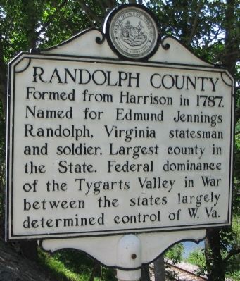
Randolph . . . — — Map (db m33928) HM
On Route 9 Bike Path, 0.2 miles south of Short Road (County Road 36/1), on the right when traveling south.
The Shaw Run Wetland Complex is a calcareous fen. A "fen" is defined as low land covered wholly or partly with water. fed by Shaw Spring and Shaw Run, the wetland is a unique type of wetland for West Virginia because of its marl substratum (layer . . . — — Map (db m150612) HM
On South Queen Street (West Virginia Route 9/45) south of East Addition Street, on the right when traveling south.
Born in Martinsburg, July 6. 1806. Member of Virginia legislature and served in Congress, 1851-1859. In 1860 he was appointed Minister to France but was arrested in 1861 on charges of negotiating sales of arms for the Confederacy. Enlisted in . . . — — Map (db m203911) HM
On East Burke Street at North Spring Street on East Burke Street.
On this site Harry Flood Byrd was born
June 10, 1887
Member of the Virginia Senate, 1916-1925
Governor of Virginia, 1926-1930
U.S. Senator from 1933.
— — Map (db m132399) HM
On King Street (U.S. 11) near Maple Avenue, on the left when traveling east.
Constructed using the Richardson-Romanesque Style of architecture, this building served as a Post Office and United States Courthouse. — — Map (db m1977) HM
On Daniel Boone Parkway (West Virginia Route 3) 0.5 miles west of the Peytona Post Office on Roundbottom Road (Local Route 119/21).
To the north, birthplace and home
of John Edward Kenna, U. S. Senator
and prominent figure in the early
life of this State. His statue
stands among the notables of other
States in the Hall of Columns in
the national capitol in Washington. — — Map (db m137454) HM
On Main Street (West Virginia Route 67), on the right when traveling west. Reported missing.
Here lived the leading influence in America's largest indigenous religious movement, Christian Church (Disciples of Christ), and founder of Bethany College. Built in four periods: the John Brown Mansion, completed in 1793; Buffalo Seminary, in 1819; . . . — — Map (db m20826) HM
Near College Street at Main Street (West Virginia Route 67).
A major grant from the Renner Foundation, which was matched by alumni gifts, made possible, in 1970, the complete remodeling of Bethany House built in 1948. Henry Clay and James A. Garfield were among the notable guest at the first Bethany House . . . — — Map (db m79901) HM
On Commerce Street (West Virginia Route 2) north of 12th Street, on the right when traveling south.
Born in Wellsburg. January 8. 1819, Tarr opposed Virginia secession in 1861. A staunch Unionist. he was a delegate to the first and second Wheeling conventions, raised Union Troops, and was treasurer for the Restored Government of Virginia. He . . . — — Map (db m189408) HM
On West Virginia Route 2 at Commercial Street Exd, on the right when traveling north on State Route 2.
Born in Wellsburg in 1824, Duval worked as a scout in the western US and joined the 1849 Gold Rush before returning to Brooke County. He served in the Union Army during the Civil War. rising to the rank of major general. Postwar, Duval served terms . . . — — Map (db m167222) HM
This park has been named Nancy Cartmill Gardens in honor of Nancy Hunter Cartmill. Mrs. Cartmill was the first woman to be elected Mayor of Barboursville and served from 1993 to 2001.
Major Cartmill was instrumental in attracting business . . . — — Map (db m125915) HM
Near 4th Avenue just east of 7th Street, on the right when traveling east.
The bell was cast by Meneely Bell Company, Troy, New York and shipped to Cabell County, WV, on May 18, 1901, weighing 1,506 pounds without fittings. Due to deterioration of the cupola which housed the bell, it was removed from the top of the . . . — — Map (db m208507) HM
On 11th Street at Veterans Memorial Boulevard (U.S. 60), on the left when traveling south on 11th Street.
Born 1830 in Utica, NY, Oley was
in that state's National Guard and
came to western Virginia in 1861
to drill Union troops. He rose to
rank of brevet brigadier general
by war's end. In 1871 Oley settled
in Huntington and worked as land
agent . . . — — Map (db m178145) HM
On Bridge Street (West Virginia Route 2) at Richmond Street on Bridge Street.
Born 1839 in Cabell County, Witcher
was clerk of the court, and in
1862 he began distinguished service
with the 3rd West Virginia Cavalry
and was appointed brevet brigadier
general by end of war. Served as
state delegate, secretary of . . . — — Map (db m125938) HM
On Midland Trail (U.S. 60) just east of Sherry Lane, on the right when traveling west.
North of here (1826-28) lived
John and Nancy Bryan, grandparents of William Jennings Bryan,
the Great Commoner. They
moved to Gallipolis Ferry
where they died; John, 1834;
Nancy in 1832. Buried nearby
in the Yatesmont Cemetery. — — Map (db m125870) HM
On Main Street (West Virginia Route 16) east of Locust Street, on the right when traveling east.
Born on December 10, 1826, he was
one of the first school teachers
in Nicholas County. He moved to
Clay County before the Civil War
and was a delegate to the first
constitutional convention for West Virginia,
1861-1863. In 1863, he organized . . . — — Map (db m137965) HM
On Procious Maysel Road (West Virginia Route 4) east of Maysel Clay Road (Local Route 26), on the right when traveling east.
To east was Claude Markle (1882-1962) home, noted road builder in Clay, Webster, Boone, & Kanawha in early 20th century. Projects include Maysel intersection of US 119/36/ & 4, Clay Jct. Route 16, & Widen ridge; bridges; tunnels; & culverts. He . . . — — Map (db m137966) HM
On West Virginia Route 18 at Porto Rico Road, on the right when traveling south on State Route 18.
21st governor of W. Va. (1941-1945), born at Grove, 1874, spent boyhood here in former town of Market. He served in Spanish American War and graduated from W. Va. Univ. before opening law practice in Fairmont. His public career included terms as . . . — — Map (db m142423) HM
On Smithton Road at East Main Street, on the right when traveling north on Smithton Road.
Born January 8, 1820, Stuart was prosecuting attorney of Doddridge County, 1852-1861. After voting against secession at the Richmond Convention, he was elected senator of the Restored Government of VA. He also served as a delegate to the . . . — — Map (db m142415) HM
On Davis Street (West Virginia Route 18) 0.1 miles north of Howell Street, on the right when traveling south.
Skirmish at West Union
Early on May 5, 1863, six companies of the 2nd WV Infantry under Col. George Latham arrived in West Union to protect area railroad bridges during the Jones-Imboden raid. Two regiments of Confederate cavalry advanced to . . . — — Map (db m142412) HM
On 2nd Avenue (West Virginia Route 61) 0.1 miles east of College Street, on the right when traveling west.
Born in slavery in Monroe Co., Sept. 7, 1848, he worked as servant in the Confederate army. Served as teacher and ordained Baptist minister; estab. West Virginia Enterprise, Pioneer, & Mountain Eagle papers; later a lawyer. First . . . — — Map (db m34413) HM
On Linn Street (County Road 5/3) 0.2 miles north of North Court Street, on the right when traveling south.
Thomas Marcellus Marshall, Glenville State Normal, Acting Principal - January 1873-June 1873; Principal - 1875-1881 •
Louis Bennett, Glenville State Normal, Principal - 1873-1875 •
Robert Franklin Kidd, Glenville State Normal, Principal . . . — — Map (db m190029) HM
On U.S. 220, 0.2 miles west of Rig Road (County Road 10), on the left when traveling west.
Grant County. Formed in 1866 from Hardy. Named for General Grant, later President. At the northwestern corner is the Fairfax Stone, which established the limits of the lands of Lord Fairfax. The county has many mountain peaks and beautiful . . . — — Map (db m162737) HM
On Court Street at Randolph Street on Court Street.
Constructed 1837 by John W. Dunn, well known local brickmason. All brick was made locally. Building has been in constant use since its completion and is unchanged except for wings added in 1937 and 1963. — — Map (db m50471) HM
On North Court Street at Preston Boulevard, on the right when traveling north on North Court Street.
Born July 28, 1805, Samuel Price served in the Virginia legislature, 1850-1841 Constitutional Convention, and 1861 Richmond Convention. From 1863 to 1865, he was Lt. Governor of Confederate Virginia. As president of West Virginia’s Constitutional . . . — — Map (db m140698) HM
Built in 1834-1835 by Stephen Henderson First Summer White House Occupied by Martin Van Buren John Tyler Millard Fillmore Franklin Pierce James Buchanan — — Map (db m85210) HM
On Bloomery Pike (West Virginia Route 127) 0.4 miles west of South Sleepy Creek Road (Route 734), on the right when traveling west.
Hampshire County
Oldest county; established by the Virginia Assembly, 1754. Formed from Frederick and Augusta. Lord Fairfax, owner, named it for the English shire of the same name. Ice Mountain and Hanging Rocks are among its natural . . . — — Map (db m159337) HM
On East Main Street, on the right when traveling east.
This was the home of John J. Cornwell,
15th governor of W. Va. (1917-1921).
The three story Greek Revival Four Square
home was built by Governor Cornwell in 1914
and he lived there until his death in 1953. — — Map (db m203984) HM
On North River Avenue at Jefferson Street, on the right when traveling south on North River Avenue.
Hancock County, formed in 1848 in home of Sam C. Allison in Fairview, also known as Pughtown and New Manchester. In election for county seat, New Cumberland won by 13; refusal to move led to another vote and majority of 46 in 1850 to move. In May . . . — — Map (db m44124) HM
On North River Avenue at Jefferson Street, on the right when traveling south on North River Avenue.
Near New Cumberland, George Chapman settled, about 1783, and built an Indian fort. Here are graves of the Chapmans, Gregorys, Graftons, and other pioneer families. Pughtown, settled about 1810, was the first county seat. — — Map (db m44130) HM
On North River Avenue at Jefferson Street, on the right when traveling south on North River Avenue.
In 1839 John Cuppy laid out 42 lots on his farm between Ohio River and hill; added 50 lots in 1850. Named Vernon but called Cuppy Town. In 1840 John Chapman built the first house. Industry based on rich clay deposits, brick plants and river . . . — — Map (db m44135) HM
On Main Street (West Virginia Route 2) 0.1 miles north of Marland Avenue, on the right when traveling south.
Side A:Hancock CountyFormed in 1848 from Brooke. Named for John Hancock, first signer of the Declaration of Independence. Iron furnaces established in this county as early as 1794 made the cannon balls that Commodore Perry used in . . . — — Map (db m44127) HM
On West Main Street just east of South 3rd Street, on the left when traveling east.
On April 22, 1861, in Clarksburg, about 1,200 citizens of Harrison County met to oppose Virginia's proposed ordinance of secession. They supported John Carlile's call for delegates to meet on May 13 in Wheeling to determine a course of action for . . . — — Map (db m184744) HM
On West Main Street just east of South 3rd Street, on the left when traveling east.
Born in 1817, he practiced law and served in the Virginia Senate and US Congress. At the 1861 Richmond Convention, he opposed secession. Although he led efforts to create a new state and wrote "A Declaration of the People of Virginia" calling for a . . . — — Map (db m184802) HM
On East Pike Street (West Virginia Route 20) west of Charleston Avenue, on the left when traveling west.
In this cemetery lie buried members of the Stonewall Jackson family: his father Jonathan, a sister Elizabeth, his great grandparents John Jackson and wife Elizabeth Cummings. Buried here also are Mrs. Mary Payne Jackson and Mrs. Mary Coles Payne, . . . — — Map (db m175548) HM
On West Pike Street (West Virginia Route 20) at North 4th Street, on the right when traveling west on West Pike Street.
Waldomore.
Built by Waldo P. Goff, father of
Nathan Goff, in 1842, Waldomore is
a two-story Neo-Classical Revival
brick mansion used as the family
home until the death of May Goff
Lowndes in 1930. Left by her to
the City of Clarksburg . . . — — Map (db m174510) HM
On Moore Street, 0.1 miles south of West Main Street (Local Route 50/28), on the right when traveling south.
The West Virginia Industrial
Home for Girls was established by act of the Legislature,
February 18, 1897, for the rehabilitation of girls who need
assistance in becoming useful
citizens of the State. It was
formally opened May 5, 1899. — — Map (db m174654) HM
On Hood Avenue (U.S. 19) 0.2 miles east of Branch of West Fork, on the right when traveling north.
Born in 1837, Hall worked at the Wheeling Intelligencer during the Civil War. His reporting during the creation of WV served as the basis for his publication, The Rending of Virginia. Hall also recorded the proceedings of the . . . — — Map (db m125819) HM
On U.S. 340, 0.1 miles west of Union Street, on the right when traveling west.
United States Marine
Killed 18 October 1859
During the capture of John Brown
Flagpole and gravesite rededicated by
Marine Corps League Detachment 1143
13 0ctober 2012 — — Map (db m104281) HM WM
On South Lawrence Street, 0.1 miles south of West Washington Street, on the right when traveling south.
Erected in tribute to Martin Robinson Delany
Born free May 6, 1812 Lawrence and North Streets Charles Town, VA (W VA) Son of Samuel Delany (slave) and Patti Peace Delany (free) grandson of African prince Prince Hall Mason physician, scientist, . . . — — Map (db m168916) HM
On George Street (West Virginia Route 115) at Washington Street (West Virginia Route 51), on the right when traveling north on George Street.
One of the most famous trials in American history was held in this building in 1859, when John Brown and his followers faced charges of treason against Virginia, inciting slaves to rebel, and murder. Judge Richard Parker presided.
The trial . . . — — Map (db m170247) HM
On Potomac Street, 0.1 miles north of Shenandoah Street, on the right when traveling north.
Along this path lie the remains of revolutions. Six acres of the U.S. Armory at Harpers Ferry have been reduced to rubble. Buildings that buzzed with activity and innovation now lie covered with dirt. Train tracks that pushed to the edge of a new . . . — — Map (db m20475) HM
On Princess Street, on the right when traveling south.
Shepherd District Free School 1848-1881Given to the West Virginia board of education for Shepherd College by Upton S. Martin in memory of his father, U.S. Martin (1859-1957), 32nd degree mason, Mayor of Shepherdstown six years, member West . . . — — Map (db m23845) HM
On Kanawha Boulevard East (U.S. 60) east of Greenbrier Street, on the right when traveling east.
Abraham Lincoln was elected the
16th president of the U.S. in 1860.
He received fewer than 2,000 votes
in Virginia, most from present-day West Virginia.
Lincoln preserved the Union, ended
slavery, and played the decisive
role in the admission . . . — — Map (db m137890) HM
On Kanawha Boulevard, 0.1 miles west of California Avenue, on the left when traveling east.
[East Side]
"Abraham Lincoln Walks At Midnight" from poem by Vachel Lindsay
Sculptor
Fred Martin Torrey 1884-1967
Born in Fairmont, West Virginia
Dedicated
June 20, 1974
Arch A. Moore, Jr. Governor
[South Side] . . . — — Map (db m23019) HM
On Virginia Street East at Court Street, on the right when traveling east on Virginia Street East.
Kanawha County formed November 14, 1788
Organized October 6, 1789
Gentlemen justices qualified as members of the county court
Thomas Lewis •
Robert Clendenin •
Francis Watkins •
Charles McClung •
Benjamin Strother •
William . . . — — Map (db m178791) HM
On Washington Street East (U.S. 60) just west of Clay Square, on the right when traveling west.
The Mary Price Ratrie Greenspace has transformed an ordinary asphalt parking lot across the street from the Clay Center into a slice of West Virginia natural heritage. The site features stacked terraces that establish a backdrop resembling the . . . — — Map (db m178503) HM
On Kanawha Boulevard West west of Bream Street, on the left when traveling west.
Born 1791 in New York, he moved to Kanawha County to practice medicine and became a prominent politician. He served several terms in the VA Assembly and opposed secession at the 1861 Richmond Convention. In 1863, Patrick was elected to the WV House . . . — — Map (db m228737) HM
On Kanawha Boulevard just west of California Avenue, on the right when traveling east.
West Virginia's Capitol first located in Wheeling, 1863; moved to Charleston, 1870; back to Wheeling, 1875; and finally to Charleston, 1885. It was located two miles west until destroyed by fire, 1921. Present building was completed in 1931. — — Map (db m23018) HM
On Lee Street (U.S. 60) at Hale Street, on the right when traveling east on Lee Street.
stood on the block bounded by Lee, Dickenson, Washington and Capitol Streets
in memory of Charles Walker volunteer died fighting the Capitol fire Jan. 3rd 1921 — — Map (db m178796) HM
On Kanawha Boulevard West just east of Florida Street, on the right when traveling east.
Born in Ohio in 1848, Davis served during the Civil War in the Union Light Guard of Ohio that was tasked with protecting President Lincoln. After the war, he moved to present-day Malden and later Charleston, where he served as an educator. His . . . — — Map (db m178787) HM
On Malden Drive just south of Commerce Drive, on the right when traveling south.
Born 1797, he was a prominent salt manufacturer in the Kanawha Valley. A member of the Restored Government of VA and Constitutional Convention for WV statehood, he was a major general in the state militia and served in the House of Delegates, . . . — — Map (db m178851) HM
Home of Jonathan M. Bennett built 1875 and used as family home until 1922. Given by Mrs. Louis Bennett to county as public library to honor her husband and son. J.M. Bennett (1816 ~ 87) was active in state political and local business affairs in . . . — — Map (db m64089) HM
On Lynn Avenue (West Virginia Route 3) just west of First Street.
Founded 1975 in a renovated store by people of Lincoln County. First in nation to be federally designated as rural health clinic under PL 95-210. Hailed as model care provider, successfully building on community support, dedicated staff and Marshall . . . — — Map (db m178248) HM
On McClellan Highway (West Virginia Route 10) 0.1 miles north of Black Diamond Drive, on the right when traveling south.
Logan County. Formed in 1824 from Cabell, Kanawha, Giles and Tazewell. Named for Logan, the famous chief of the Mingo Indians, whose "Lament" is most noted example of Indian eloquence. Cornstalk's duaghter, Aracoma, is buried in the town of . . . — — Map (db m159924) HM
On Little Buffalo Creek Road (County Road 10/02) at Route 801, on the right when traveling west on Little Buffalo Creek Road.
"I appeal to any white man to say, if ever he entered Logan's cabin hungry, and
he gave him not meat, if ever he came cold and naked, and he clothed him not.
During the course of the last long and bloody war, Logan remained idle in his
cabin, . . . — — Map (db m164725) HM
On Little Buffalo Creek Road (County Road 10/02) 0.2 miles west of Route 801, on the right when traveling west.
This bell was placed in the belltower of the Logan County Courthouse in 1905. It
was made by American Bell and Foundry Company of Northville, Michigan and weighs approximately 2000 pounds.
In 1912 the courthouse burned and this same bell was . . . — — Map (db m164724) HM
On Adams Street (U.S. 250) at Jefferson Street, on the left when traveling north on Adams Street.
Home of Francis H. Pierpont, whose services in the organization of this State are commemorated by his statue in Statuary Hall, Washington. He was governor under the Restored Government of the State of Virginia, 1861–1868. — — Map (db m21313) HM
On Adams Street (U.S. 19/250) just east of Cleveland Avenue (U.S. 19/250), on the right when traveling west.
Born 1814, Francis Pierpont was a
respected lawyer and supporter of
the Union. Delegate in 1861 to the
Wheeling conventions, he became
governor of Restored Virginia and
aided efforts to form a new state.
Postwar, he oversaw the rebuilding
of . . . — — Map (db m175079) HM
On Maple Avenue at Pennsylvania Avenue (U.S. 19), on the left when traveling east on Maple Avenue.
Francis H. Pierpont, governor of the Restored Government of Virginia and the "Father of West Virginia" died on March 24, 1899. He is buried here with his wife, Julia Augusta Robertson Pierpont. They first met when he interviewed her in 1847 for a . . . — — Map (db m172346) HM
On Paw Paw Creek Road (West Virginia Route 218) at Jamison Road (West Virginia Route 218), on the right when traveling east on Paw Paw Creek Road.
Born in 1878 in Basnettville, Marion Co. President of Women's Christian Temperance Union by 1908; led state suffrage movement in 1917, resulting in 1920 passage of 19th Amendment giving women right to vote. She was first woman to chair WV Republican . . . — — Map (db m189043) HM
On U.S. 250 at Main Street (West Virginia Route 218), on the left when traveling south on U.S. 250.
Explosion in Consolidated Coal No. 9 mine November 20, 1968 resulted in deaths of 78 miners, with only 21 men rescued. Mine sealed ten days later due to fires and explosions. In 1969 recovery efforts began. Over ten year period the bodies of 59 . . . — — Map (db m188586) HM
On Main Street (West Virginia Route 218) just north of U.S. 250, on the left when traveling north.
A mile north stood the cabin in which Waitman T. Willey, the State’s first U.S. Senator was born, October 18, 1811. Elected August 4, 1863 by the Legislature, he served until March 3, 1871. Died May 2, 1900; buried in Morgantown. — — Map (db m21130) HM
On East Main Street (U.S. 250) at Mead Avenue, on the right when traveling south on East Main Street.
This property
is a significant part
of the
Mannington
Historic District
Placed on the
National Register of
Historic Places
1996 — — Map (db m164995) HM
On Freedom Highway (U.S. 19) at Teacher Lane, on the right when traveling north on Freedom Highway.
Harrison County. Formed, 1784, from Monongalia. It included all or parts of
17 other counties. Named for Benjamin Harrison, signer of Declaration of Independence,
and governor of Virginia, 1781-1784. Birthplace of General Thomas J. . . . — — Map (db m164985) HM
On Energy Road (West Virginia Route 2) 0.1 miles north of Teletech Drive, on the right when traveling north.
Born January 20, 1820, Trainer worked as a tailor before becoming a Methodist minister. An opponent of secession, he was a delegate to the state's first Constitutional Convention and served as chaplain of the 12th WV Infantry during the Civil War. . . . — — Map (db m189433) HM
On West Virginia Route 2 south of Woodland and Graysville Road, on the left when traveling south.
General Zachary Taylor, on his way to Washington to be inaugurated as the 12th President of the U.S., found his steamer blocked by ice here. He left his boat and completed his trip over the National Pike. — — Map (db m54810) HM
On Fairmont Pike Road (West Virginia Route 88) north of Sherrard Drive, on the right when traveling north.
Born in 1820, Clemens studied law at Washington College (PA) and was admitted to the bar in 1843, then established a practice in Wheeling. Serving in the U.S. House, 1852-53 and 1857-61, he was a delegate to the Richmond Convention of 1861, where he . . . — — Map (db m190873) HM
On Viand Street at 7th Street, on the left when traveling north on Viand Street.
Judge Daniel W. Polsley and family moved here in
1865. Polsley was the only person to hold the office
of Lieutenant Governor of the Reorganized State of
Virginia (1861-1863) prior to the actual formation
of West Virginia in 1863. Polsley served . . . — — Map (db m189743) HM
On Main Street just south of 8th Street, on the left when traveling north.
This home was built by John Hale in 1836, in the Jenny Lynn style. Later a second floor was added and lap siding was applied. Some time after 1873 the north and south gables were added. John Hall, pres. of the First Constitutional Congress of West . . . — — Map (db m178670) HM
On Main Street just north of 8th Street, on the left when traveling north.
This was the home of G.P. Gardner. Mr. Gardner served during the Civil War as a member of the First West Virginia Artillery. He was the owner of a local dock and sawmill. Gardner held the offices of Road Supervisor, School Commissioner, County . . . — — Map (db m178672) HM
On Main Street just north of 9th Street, on the right when traveling north.
The home of Judge John Warth English and Mrs. Fanny Lewis English was built in 1863. Judge English served on the West Virginia Supreme Court for 12 years. His former law office was located in rear of the house. Mrs. English was a descendant of . . . — — Map (db m189714) HM
On Main Street just north of 6th Street (County Road 62/29), on the right when traveling south.
This three-story, brick structure was built in 1901 for Drs. Andrew and Hugh Barbee, father and son. The first floor housed the post office, the second the doctors' offices and the third, the masonic hall. Dr. Andrew came to Pt. Pleasant in 1868 to . . . — — Map (db m178662) HM
On Ohio River Road (West Virginia Route 62) east of Airport Road (Local Road 64/4), on the left when traveling west.
Born 1805 in Ireland but moved to Mason County as a child. He served as sheriff and in both houses of Virginia legislature. Delegate to the first Wheeling convention, he was elected president of the first constitutional convention, serving 1861-62 . . . — — Map (db m125016) HM
On Jackson Avenue (West Virginia Route 62) south of 27th Street, on the right when traveling north.
Born May 6, 1821, Whaley served as a Union recruiter and colonel in the 9th WV Volunteer Infantry. He was captured November 10, 1861, in Guyandotte during the battle there but escaped. First elected to the U.S. Congress in 1861, in 1863 he became . . . — — Map (db m125031) HM
On Cherokee Road (County Route 17) 5.8 miles Coal Heritage Road in Northfork (U.S. 52), on the left when traveling east.
Child labor was common in West Virginia during the hand loading era, which took place from the onset of coal mining in the 19th century until around 1930. Mining was a skilled craft, and it took a number of years to learn. A young miner usually . . . — — Map (db m178964) HM
On U.S. 52 at Steam Engine Drive (Local Route 52/19), on the right when traveling north on U.S. 52.
First black woman elected to West Virginia legislature, 1950; retied in 1964. Leading advocate for labor and education; in 1955 she sponsored bill to allow women to serve on juries. Born 22 September 1893, she began teaching in 1910. Drewry served . . . — — Map (db m1822) HM
On McDowell Street just south of Utility Street, on the right when traveling south.
By proclamation of Welch City Council, Tug Street was renamed in honor of Mayor Martha H. Moore. Martha H. Moore was the 25” person to serve as mayor of the City of Welch. Martha Moore was born in Welch and began her public service to the city she . . . — — Map (db m203918) HM
On Coal Heritage Highway (U.S. 52) 1.1 miles west of Riverside Drive (West Virginia Route 103), on the right when traveling south.
McDowell County had no slaves in 1960, but when civil war came in 1961 many residents supported the Confederacy and the county took no part in early WV statehood efforts. Constitutional Convention delegates debated the inclusion of McDowell and . . . — — Map (db m178643) HM
The first woman elected to Congress from West Virginia. Born as Maude Etta Simpkins on June 7, 1895, she married Bluefield lawyer John Kee, who served in congress, 1932–1951. Employed 18 years as his secretary; elected to complete his term in 1951; . . . — — Map (db m1821) HM
On U.S. 19 at Toad Level Road, on the right when traveling north on U.S. 19.
Here in 1862 was stationed the 23rd Ohio Regt., U.S.A. Encamped here were Gen. J.D. Cox, Maj. R.B. Hayes and Sergt. William McKinley. All became governors of Ohio; Hayes and McKinley became Presidents of the United States. — — Map (db m42175) HM
On Carskadon Road just south of Reynolds Terrace, on the right when traveling south.
Notable because Thomas R. Carskadon was a Vice-Presidential Candidate in 1892. He was considered radical because of his modern ideas on farming, politics, his inventions and life in general. His home had plumbing and conveniences ahead of the . . . — — Map (db m196550) HM
On East Street at Armstrong Street (West Virginia Route 46), on the left when traveling south on East Street.
WV became a border state in 1863 when it separated from Virginia. The Mineral County Courthouse was completed in 1868 after Mineral County was created from Hampshire County. This area around the Court House became the Town Square. The Court House is . . . — — Map (db m152821) HM
On Armstrong Street (West Virginia Route 46) at West Street on Armstrong Street.
Old Union Blacksmith Shop on East Street was on this Square, as well as a second one located at 107 West Street. The first school building built for white children stood where the Magistrate Court Annex is now located on West Street. About 1870 a . . . — — Map (db m152820) HM
On South Mineral Street just south of Carskadon Lane, on the left when traveling south.
Born in Hampshire County in 1837, the son of a slave owner, he fled Virginia after secession but was elected the youngest member of the Constitutional Convention in 1861. He later served as US assessor, a presidential elector for Grant and Hayes, . . . — — Map (db m196549) HM
On East 2nd Avenue just east of Court Street, on the left when traveling west.
"I appeal to any white man to say if ever he entered Logan's cabin and hungry, I gave him not meat; if he ever came cold or naked and I gave him not meat; if he ever came cold or naked and I gave him not clothing.
"During the course of the . . . — — Map (db m178579) HM WM
On Point Marion Road (U.S. 119) north of Pinehurst Drive, on the right when traveling south.
Born in Monongalia County in 1827, he was a delegate to the First and Second Wheeling Conventions and a member of the Restored Government of Virginia. Appointed colonel of the 7th WV Infantry in 1862, he was wounded at Fredericksburg. In late 1863, . . . — — Map (db m104396) HM
On Willey Street at University Avenue, on the right when traveling north on Willey Street.
This apple tree (Malus domestica), Flower of Kent variety, is a direct descendant of the one that dropped that famous apple on Sir Isaac Newton, inspiring his theory of gravity.
It grew from a sapling given to Senator John D. Rockefeller IV by . . . — — Map (db m175238) HM
On Scotts Run Road (County Road 19/25) at Number Three Hill Road (County Road 19/26), on the right when traveling south on Scotts Run Road.
First Lady Eleanor Roosevelt visited Scott's Run in 1933 in the height of the Great Depression when FDR was creating the New Deal. She visited households without fanfare (including Lou Birurakis' mother) and even went into the mines. Upon seeing the . . . — — Map (db m176173) HM
Near Frontier Street at University Avenue, on the left when traveling north.
The Citizens Party
In their first municipal elections on June 14, 1907, Star City's residents voted for a slate of citizen candidates without party affiliation who ran unopposed. They directed the operation of the schoolhouse, organized in . . . — — Map (db m200179) HM
180 entries matched your criteria. The first 100 are listed above. The final 80 ⊳