On Academy Drive, on the right when traveling east.
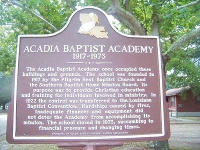
The Acadia Baptist Academy once occupied these buildings and grounds. The school was founded in 1917 by the Pilgrim Rest Baptist Church and the Southern Baptist Home Mission Board. Its purpose was to provide Christian education and training for . . . — — Map (db m89002) HM
On Hickory Flat Road, 1.4 miles north of U.S. 165, on the left when traveling north.
This property served as the first African-American school in Allen Parish until 1945. The land was deeded to the church in 1911 by Julian and his wife Modeste Captain. *School established in 1880 with Lawrence Shaw as first teacher. The original . . . — — Map (db m189219) HM
On Lessard Street at Williams Street, on the right when traveling north on Lessard Street.
This quiet neighborhood between the river and the railroad retains a number of historic features related to the struggles and achievements of Louisiana African Americans. The Rosenwald School building in front of you was relocated from a site 15 . . . — — Map (db m155974) HM
It began in 1912, Booker T. Washington, President of Tuskegee Institute,
approached Julius Rosenwald, President of Sears, Roebuck and Company, with
an idea for a pilot program that was to have a dramatic impact on the face of
America. . . . — — Map (db m154213) HM
On State Highway 308 at Freetown Rd., on the left when traveling south on State Highway 308.
Israel Baptist School. In 1872, Reverend Osborne Dickerson and the First Israel B. C. congregation organized the Baptist Church School on this site to provide formal education for African American children. In 1877, Assumption Parish School . . . — — Map (db m86041) HM
On Main Street (State Highway 29) at College Street, on the right when traveling north on Main Street.
Site of Evergreen Home Institute (1856); Henry Clay Kemper, 1st headmaster. Later became Evergreen College; then Evergreen High School in 1904. These schools had a note-worthy influence on education in Avoyelles and Louisiana. — — Map (db m97455) HM
On East Mark Street west of South Preston Street, on the left when traveling west.
Founded by
Rev. Fr. Nicholas Juderman
as a school for Black Catholic
children. Land donated by
Daughters of the Cross.
Funding obtained from
Mother Katherine Drexel,
founder of the Sisters of
the Blessed Sacrament.
Opened in 1917. First . . . — — Map (db m122502) HM
On South Washington Street north of East Wadill Street, on the right when traveling north.
Founded by the Daughters of the Cross of Treguier, France in 1854 at Hydropolis (Cocoville), and relocated to this site after the Civil War. First Catholic girls' school in Avoyelles Parish. Later became co-educational. — — Map (db m122415) HM
On South Washington Street south of Ronald Reagan Highway (U.S. 190), on the left when traveling south.
Sam Houston Jones (1897 -1978) was born in Merryville and spent his youth in DeRidder. He is the only native of Beauregard Parish ever elected Governor of Louisiana. Jones graduated from DeRidder High School in 1915. He then enrolled at Louisiana . . . — — Map (db m140517) HM
On State Highway 26 at Don Gray Road, on the right when traveling east on State Highway 26.
Built 1919-used as a
school until 1928. Bought
by community families to
be used for cultural
and social activities.
Placed on the National
Register of Historic
Places December 2002. — — Map (db m125177) HM
On Bossier Street at Bellevue Street, on the right when traveling south on Bossier Street.
Built in circa 1840 by Alex B. Hughes, the house remained in the Hughes family until its donation to the Bossier Restoration Foundation in 1972. This was the boyhood home of William Clark Hughes who was the Speaker of the Louisiana House of . . . — — Map (db m109778) HM
On Gray Street (Louisiana Route 3049) north of Olympia Road, on the right when traveling north.
Grades 1-11 1921-1947
Grades 1-12 1948-1955
Grades 1-8 1956-1969
Dedicated to the Principals, Faculty and Students who made this school such a special part of our lives. This was education as it should be.
Dedicated by the Friends of . . . — — Map (db m175303) HM
On Dixie Shreveport Road (Louisiana Route 3049) 0.5 miles north of Whitefield Circle, on the right when traveling north.
The former Rosenwald School at Cash Point was built in 1923-24 for a cost of $2,300.00 as a two teacher frame school. The Rosenwald Fund was developed by Julius Rosenwald, CEO of Sears, Roebuck & Company, and educator, Booker T. Washington in . . . — — Map (db m175959) HM
On Weinstock Street west of Pierre Avenue, on the left when traveling west.
Built 1917 as Central Colored High School. Later a Junior High School and today an Elementary School. Listed in National Register of Historic Places, 1991. — — Map (db m142859) HM
On Youree Drive (State Highway 1) at Ockley Drive on Youree Drive.
Built as Broadmoor School in 1929. Renamed in memory of Albert Coldwell Steere (1879-1930), influential businessman, philanthropist and real estate developer, and creator of Broadmoor area. Expanded 1938. Listed in National Register of Historic . . . — — Map (db m143801) HM
On Line Avenue south of Kings Highway, on the right when traveling north.
Built 1925 as New Shreveport High School. Re-named 1926 in memory of prominent local educator Dr. Clifton Ellis Byrd, who laid the building's cornerstone. Listed in National Register of Historic Places, 1991. — — Map (db m143741) HM
On Ockley Drive east of College Lane, on the right when traveling east.
Private liberal arts junior college for girls, 1927-1942. Founded by Dr. M.E. Dodd, Pastor, First Baptist Church, Shreveport. Two original buildings now part of First Baptist Church. President's Home located at 601 Ockley Drive. — — Map (db m140561) HM
On Ockley Drive at College Lane, on the right when traveling east on Ockley Drive.
Now called "Medjoy". Built 1929 as Dodd College President's Residence. Dodd College, named for its founder Dr. M.E. Dodd, operated 1926-1942. This house was Dr. Dodd's residence for many years, Listed in the National Register of Historic Places, . . . — — Map (db m143799) HM
On Edwards Street south of Travis Street, on the left when traveling north.
Built 1922, under the administration of Mayor John McWilliams Ford, to house Shreve Memorial Library. Designed by J. P. Annan in style of Roman Villa. Remained in use as central public library for over half a century. — — Map (db m139538) HM
On Edwards Street north of Texas Avenue (U.S. 79/80), on the left when traveling north.
Built 1922, under the administration of Mayor John McWilliams Ford to house Shreve Memorial Library. Designed by J. P. Annan in style of Roman Villa. Remained in use as Central Public Library for over half a century. — — Map (db m139864) HM
On Texas Street (U.S. 79/80) at Marshall Street, on the right when traveling west on Texas Street.
Built 1911 as Federal Court House and Post Office, expanded in 1931. Remained in use as federal Building until 1972. Has housed Shreve Memorial Library's central branch since 1970s. Listed in National Register of Historic Places, 1974, when interior . . . — — Map (db m109763) HM
On Sexton Street east of Centenary Boulevard, on the left when traveling east.
Founded 1825 at Jackson, La., by the State of Louisiana, the college was transferred to the Methodist Church in 1845. Relocated at Shreveport in 1908. Centenary is the oldest privately operated liberal arts college west of the Mississippi. — — Map (db m142362) HM
On Line Avenue near Wichita Street, on the right when traveling south.
Built 1904-05. Designed by noted local architect N.S. Allen. One of only 5 known Allen designed buildings remaining in Shreveport. Listed in The National Register of Historic Places, 1981. (1800 Line Avenue) — — Map (db m142708) HM
On Highland Avenue at Wyandotte Street, on the right when traveling north on Highland Avenue.
Built 1909. Was former residence of Governor Ruffin G. Pleasant and wife Annie Ector Pleasant. Mrs. Pleasant founded a private school which operated here for many years. — — Map (db m142332) HM
On Ryan Street (State Highway 385) north of West School Street, on the left when traveling north.
In 1903, Mesard LaGrange donated an acre for a one-room schoolhouse at this site, and in 1913 offered to donate 9 more acres for an expansion of the school. The School Board at the time offered him $1000 for the land to obtain clear title. In 1929, . . . — — Map (db m116338) HM
On Ryan Street (State Highway 385) at Seventh Street/Dr. Michael Debakey Drive, on the right when traveling south on Ryan Street.
The original site of St. Charles Academy was the northeast corner of Ryan and Kirby, part of the Roman Catholic complex of church, convent and school destroyed in the Great Fire of 1910. Opening in 1882, St. Charles Academy was staffed by the . . . — — Map (db m116323) HM
On Arizona Road (Louisiana Route 806) north of Tower Road, on the right when traveling south.
Donated by Joshua Willis to J. W. Nicholson who organized a private school 1867-1869. Was one of the leading academies in the state. Became public school 1910. Nicholson later president of L. S. U. School. Т.Н. Harris a noted graduate. — — Map (db m138579) HM
On U.S. 79 at Hatter Street, on the left when traveling north on U.S. 79.
Haynesville Colored School was built in 1927 on twelve acres of land donated by Verge White. From 1933-1959, the school was named Haynesville Colored High School. The name was changed in 1960 to Carter G. Woodson High School with the class of . . . — — Map (db m180167) HM
On St. John Road (Parish Road 173) 0.1 miles north of Buster Johnson Road.
On this site in 1916, the St. John community donated land and logs to construct a Rosenwald school building for the negro children of the community. Earlier schools were established at St. John Missionary Baptist and later a small one room . . . — — Map (db m180161) HM
On Louisiana Route 2 at Arizona Road on State Route 2.
Thomas H. Harris served as State Superintendent of Education from 1908 to 1940. His tenure was the longest and, arguably, the most successful in the history of Louisiana education. Under his leadership, Louisiana's public school system . . . — — Map (db m180153) HM
On Louisiana Route 2 at Buck Green Road on State Route 2.
Cane Ridge
Washington B. Nicholson and Martha Wafer Nicholson arrived in Claiborne Parish in late 1844, and settled at "Parker's Creek," a now-unknown location. In the summer of 1846, they moved to this location, calling it "Cane Ridge." . . . — — Map (db m221263) HM
On St Louis Street at North Boulevard, on the left when traveling north on St Louis Street.
Considered one of the founders of the modern jazz scene, Alvin Batiste was an avant garde jazz clarinetist and educator. He shared his wisdom and musicianship with numerous students through the Batiste Jazz Institute at Southern University in Baton . . . — — Map (db m96601) HM
One Man's Dream
In 1973 Joe Martin, Jr. decided to make his dream of
training individuals for industry a reality. Recognizing
a need for qualified instrumentation technicians, he
began to build what has evolved today into ITI
Technical . . . — — Map (db m239002) HM
Near South River Road west of Government Street (Louisiana Highway 73), on the right when traveling south.
During his more than forty years of service with the Marine Corps, John A. Lejeune participated in campaigns in Panama, Cuba, Mexico, France and Germany. He led the famed 2nd Division, American Expeditionary Force, during World War I with valor and . . . — — Map (db m88608) HM WM
On Chapelwood Drive south of Woodland Ridge Boulevard, on the right when traveling south.
Original Site
On February 1, 1968, the donation of 20 acres to the Episcopal Diocese of Louisiana was received and ground broken on this site by the Rt. Rev. Iveson B. Noland for the construction of Episcopal High School.
Donors of . . . — — Map (db m97659) HM
On Mayflower Street at St Charles Street, on the right when traveling east on Mayflower Street.
Site of the Baton Rouge College 1838-44, and the Louisiana Institute for the Deaf and Blind 1852-72. A five-story brick building completed in 1858 was used as a general hospital during the Union occupation of the city. It housed the Louisiana State . . . — — Map (db m96680) HM
Near Airline Highway (U.S. 61) 1 mile south of Highland Road (State Highway 42), on the right when traveling south.
In 1775, next to Bayou Manchac, Bartram Travelled a "road strait, spacious" and "under the shadow of a grand forest." In memory Of Fred G. Benton, Jr., Bartram Trail Supporter — — Map (db m107914) HM
On State Capitol Drive near North 5th Street, on the right when traveling east.
This building, erected c. 1835 as a powder magazine for a U.S. Army Post and Arsenal which used this area from 1810-1885, except in 1861-1862 when held by the Confederacy. In 1962 this building was restored and the museum established. — — Map (db m113860) HM
On Spanish Town Rd. near N. 4th Street, on the right when traveling east.
In 1885, Louisiana State University moved from Mid-State city of Alexandria to this site, taking over the decommissioned Baton Rouge Arsenal. Nicknamed the "Old War Skule" on these grounds LSU saw its first intercollegiate football game, regular . . . — — Map (db m87429) HM
On North 3rd Street south of State Capitol Drive, on the left when traveling south.
Site of the
Louisiana State University
1886 - 1925
This marker
erected by the last generation
of the
Cadets of the 'Ole War Skule'
To honor the men and women
who attended or served
Louisiana State University
while on these . . . — — Map (db m85698) HM
Near North 3rd Street south of State Capitol Drive, on the right when traveling south.
Constructed 1819-1822 to house U.S. troops. Used as a garrison from 1822-1877 except from 1861-1862 when held by Confederates. From 1886-1925 these buildings and grounds were the site of Louisiana State University. — — Map (db m85704) HM
On North Street at North 4th Street, on the right when traveling west on North Street.
The Brothers of the Sacred Heart founded St. Vincent's Academy on this site in 1894. In 1929 the school for boys was replaced by a larger facility and renamed Catholic High School. In 1957 the school was moved to its present location on Hearthstone . . . — — Map (db m87444) HM
Near Essen Lane (State Road 3064) south of Interstate 10, on the right when traveling south.
The kitchen was built c. 1840 on Bagatelle Plantation near Union, Louisiana. It served as a kitchen originally but was later converted to a schoolhouse that was run by 3 of the Tureaud sisters. The building was changed back to a kitchen upon being . . . — — Map (db m112095) HM
On West Lakeshore Drive, 0.1 miles east of South Campus Drive, on the right when traveling west.
Delta Zeta Sorority was founded at Miami University in 1902. The second oldest sorority on campus, the Sigma chapter was the first established in the South on November 30, 1917.
Find within the walls of this home a sisterhood inspired by . . . — — Map (db m95025) HM
On South Stadium Drive near South Campus Drive, on the right when traveling east.
Dedicated by the Louisiana Department Reserve Officers Association of the United States to those Cadets who have distinguished themselves by their outstanding attention to duty their scholarly attainments and their preparation of of . . . — — Map (db m104461) HM WM
On South Stadium Drive near South Campus Drive, on the right when traveling east.
Dedicated by the Louisiana Department Reserve Officers Association of the United States to those Cadets who have distinguished themselves by their outstanding attention to duty their scholarly attainments and their preparation of of . . . — — Map (db m104463) HM WM
On South Stadium Drive near South Campus Drive, on the right when traveling east.
Dedicated by the Louisiana Department Reserve Officers Association of the United States to those Cadets who have distinguished themselves by their outstanding attention to duty their scholarly attainments and their preparation of of . . . — — Map (db m104484) HM WM
On South Stadium Drive near South Campus Drive, on the right when traveling east.
Dedicated by the Louisiana Department Reserve Officers Association of the United States to those Cadets who have distinguished themselves by their outstanding attention to duty their scholarly attainments and their preparation of of . . . — — Map (db m104675) HM WM
On West Stadium Dive north of South Stadium Drive, on the right when traveling north.
Ja'Marr Chase cemented his name as one of the top players
in SEC history in 2019, winning the Biletnikoff Award as the
nation's top receiver and becoming the first wide receiver in
LSU history to earn unanimous All-America honors. In . . . — — Map (db m173602) HM
On West Stadium Drive north of South Stadium Drive, on the right when traveling north.
One of the finest all-around players in Tiger history, he was named All-American and finished second in the Heisman Trophy balloting in 1962. Twice named All-SEC, he was a star defensive back for nine years with St. Louis. He served as LSU's head . . . — — Map (db m104389) HM
On Highland Road at South Campus Drive, on the right when traveling east on Highland Road.
The French HouseThe French House--La Maison Française--is a Renaissance-style Normandy château built in 1935 as a center for intense study of French language, culture and literature. On April 15, 1935, French Ambassador André de . . . — — Map (db m111580) HM
On Tower Drive, 0.1 miles Dalrymple Drive, on the right when traveling south.
(plaque 1)
Land Grant College
Congress, through the Morrill Act of of 1862, donated 210,000 acres of public land to Louisiana to provide a college "For the benefit of Agriculture and the Mechanical Arts." The land and underlying . . . — — Map (db m91023) HM
On Tower Drive, 0.1 miles south of Dalrymple Drive, on the right when traveling south.
This stone came from the foundation of the first building erected for the university, then called the Louisiana State Seminary of Learning located near Alexandria, LA. This building was constructed in 1859 and was occupied by the seminary from . . . — — Map (db m91016) HM
On South Stadium Drive at East Parker Boulevard on South Stadium Drive.
About the Area With its Italian Renaissance-style buildings
nestled amongst the stately oaks and broad
magnolias made famous in its Alma Mater,
LSU is truly a joy to behold. The 2000-acre
campus, bordered on its western edge by the
mighty . . . — — Map (db m120266) HM
On Tower Drive, 0.1 miles south of Dalrymple Drive, on the right when traveling south.
Louisiana State University and Agricultural and Mechanical College began as the Louisiana State Seminary of Learning and Military Academy, opening its door for the first session on January 2, 1860 at Pineville, LA.
William Tecumseh Sherman was . . . — — Map (db m91003) HM
On Fieldhouse Drive near North Stadium Drive, on the right when traveling east.
Memorial Hall, the home of the Manship School, is the oldest building on the campus. For many years known as Alumni Hall and later the Journalism Building, it was built on the old Baton Rouge campus in 1904 as a memorial to David French Boyd, the . . . — — Map (db m131639) HM
On North Stadium Drive at West Stadium Road, on the right when traveling west on North Stadium Drive.
Panel 1 About our Tiger Other mascots were proposed during the first 40 years of LSU's football team, but the tiger mascot stuck. From 1896 to 1924, students made paper-maché tigers that they took to football games; however, these man-made . . . — — Map (db m126601) HM
When the campus was dedicated in 1926,the Parade Ground had none of the live oak that grace its borders today. Most of these trees were planted by Steele Burden, LSU's landscape designed from 1931-1970. Please help us preserve LSU . . . — — Map (db m134262) HM
On Veterans Drive near Highland Road, on the left when traveling east.
The Parade Ground was an integral part of the original campus design created in the early 1920s by Frederick Law Olmsted Jr., one of the founders of the American Society of Landscape Architects, and Theodore Link. The semicircular streets and . . . — — Map (db m134263) HM
On Highland Road south of Dalrymple Drive, on the right when traveling south.
LSU's ROTC cadets regularly held military parades on the Parade Ground, hence the name. Practice for close-order drill was held here daily, as were formal parades in full military uniform for events such as Freshman Day, Memorial Day, and Veterans . . . — — Map (db m143880) HM
On Tower Drive south of Dalrymple Drive, on the right when traveling south.
The LSU War Memorial, located at the flagpole, was dedicated in 1998 in memory of Tiger alumni who gave their lives in the defense of our country from World War II to the present.Please help us preserve LSU history by picking up after . . . — — Map (db m143885) HM
Near Essen Lane (State Road 3064) near 10, on the right when traveling south.
Originally built as a slave cabin, this building was later converted into the kitchen for the Overseer's House. Its use as a schoolhouse began in the late 1800's and continued into the 1930's. The structure was moved to the museum from Welham . . . — — Map (db m113545) HM
Near Essen Lane (Highway 3064) south of Interstate 10, on the right when traveling south.
The Smokehouse was originally a train depot at LSU's Alex Box Stadium where students boarded the train to New Orleans. It was moved to the museum in 1973 and adapted for use as a smokehouse. Smoking meat was a method of preserving . . . — — Map (db m112096) HM
On Stadium Drive west of South Campus Drive, on the right when traveling west.
Used by Jean Étienne de Boré in 1795 to granulate sugar from Louisiana cane for the first time, thus revolutionizing Louisiana’s economy. The kettle was later bought by planter John Hill and given to Louisiana State University. — — Map (db m85702) HM
On South Stadium Drive west of Fieldhouse Drive, on the right when traveling west.
Leonard Fournette.tied an NCAA bowl record
with five touchdowns as 2oth-ranked LSU
(9-3) had little trouble in a 56-27 Texas Bowl
victory over Texas Tech. LSU set seven team
bowl records, including points (56), rushing
yards (384) and total . . . — — Map (db m144893) HM
Near Essen Lane (State Highway 3064) south of Interstate 10, on the right when traveling south.
These marble columns graced the entrance to the Hill Memorial Library which was given to L.S.U. in 1902 by John Hill, Sr. in memory of his son John Hill, Jr. Thousands of students and faculty members passed between the columns until the structure . . . — — Map (db m92560) HM
Near Tower Drive south of Dalrymple Drive, on the right when traveling south.
The Louisiana State University campus is characterized by distinctive buildings that embrace Italian Renaissance forms and features, including grainy stucco walls, graceful arches and red tile roofs.
The historic campus is an outstanding work . . . — — Map (db m89373) HM
Near Tower Drive south of Dalrymple Drive, on the left when traveling north. Reported permanently removed.
Born October 12, 1889 in Georgetown Mississippi
Died October 9, 1976 in Baton Rouge, Louisiana
Troy H. Middleton was a distinguished soldier and educator whose remarkable dual career was such that it is difficult sometimes to separate one . . . — — Map (db m127875) HM
Near Essen Lane (State Road 3064) south of Interstate 10, on the right when traveling south.
Tyrone Plantation in Rapides Parish was the largest in the parish, supporting 3,200 acres of cotton fields. It was built in 1843 by George Mason Graham.In addition to plantation life, Graham worked with board members and founded a learning . . . — — Map (db m112054) HM
On Leon Netterville Dr. south of Harding Boulevard, on the right when traveling north.
Born the eldest of three daughters to Rev. and Mrs. Richard E.
Brogdon, Dr. Julia Brogdon Purnell received a B.A. from
Allen University and an M.A. from Atlanta University.
Dr. Purnell served as the Sixteenth International President
of Alpha . . . — — Map (db m199187) HM
On Leon Netterville Drive south of James J Prestage Street, on the right when traveling south.
In memory of P.B.S. Pinchback, the first African American governor in U.S. history. Pinchback, Governor of Louisiana from Dec. 9, 1872 to Jan. 13, 1873, was born free on May 10, 1837. He was a Union Army Officer during the Civil War. In 1868, . . . — — Map (db m85026) HM
On Leon Netterville Drive at James J Prestage Street, on the right when traveling south on Leon Netterville Drive.
This institution was established in 1880 under an 1879 constitutional mandate to educate "persons of color". It was originally located in New Orleans, being one of the first colleges for blacks to receive Federal land scrip funds for agriculture and . . . — — Map (db m85680) HM
On Scenic Highway (U.S. 61) near Harding Blvd. (Louisiana Highway 408), on the right when traveling south.
First State institution of learning for Blacks. Founded in New Orleans in 1880, as State declared college. Became land grant college in 1890, moved to Baton Rouge in 1914. Founder and first president, Dr. J. S. Clark, native of Louisiana. — — Map (db m87221) HM
On North Oak Hills Parkway, 0.1 miles west of Bluebonnet Boulevard, on the right when traveling east.
The area around the swamp was settled over 200 years ago. This 101 acre Louisiana swamp and surrounding highland terrace escarpment is preserved for education and recreation. — — Map (db m97685) HM
On Port Hudson-Pride Road, 0.2 miles west of Liberty Road (State Road 409), on the right when traveling west.
On this site for approximately 75 years, a significant landmark existed that educated and developed precious lives of thousands of individuals in this area. Donated in 1906 by the families, Lea nd Browning, Pride Consolidated School started in 1907 . . . — — Map (db m136962) HM
Near College Street near Pine Street, on the right when traveling north.
Constructed between 1855 and 1857, the Main Academic Building had four stories and contained classrooms, offices, meeting halls, a gymnasium, an observatory (until 1870), and an auditorium that could seat 2,000 people in the central portion of the . . . — — Map (db m108620) HM
Near College Street near Pine Street, on the right when traveling north.
The East Wing dormitory was the first of the campus structures to be built. Built between 1832 and 1833, the building was designed by Captain Delafield, and constructed by Alexander Smith of Wilkinson County, Mississippi at a cost of $14,000.00 . . . — — Map (db m108617) HM
Near College Street near Pine Street, on the right when traveling north.
The Professor's Cottage was built in 1898 and rented to a professor and his family for about $125 per year. It was one of the faculty houses owned by the college, which included another cottage that was identical to it located approximately 40 . . . — — Map (db m108618) HM
On Charter Street (State Highway 10) east of Church Street, on the right when traveling east.
Founded as seat of justice for Feliciana Parish, 1815. College of Louisiana founded here, 1825. Became Centenary College, 1845. State insane asylum founded here, 1847. Historic district on National Register of Historic Places. — — Map (db m91969) HM
On Graham Street west of Ash Street, on the right when traveling west.
On this site stood the former Grant Parish Training School. Established in 1937, it served as the high school for the African-American population. In 1954 Grant Parish Training School became Mary E. Graham High School. Many young men and women . . . — — Map (db m136235) HM
On Howard Street (State Highway 8) west of Harvey Street, on the right when traveling east.
The first school in Pollock was established in 1893-1894. The Rev. Frank Brian, a minister and state senator was hired by the students' parents to serve as the first instructor. Located near the business district, the first school building was . . . — — Map (db m135983) HM
Prospect School had its beginning in the late 1800s, having its
first class at Prospect Baptist Church, which was across the
road from where the first building was built. In the late 1920s
or early 1930s, the first building was destroyed by a . . . — — Map (db m124015) HM
On State Highway 1240 south of State Highway 122, on the left when traveling south.
Verda was named for the daughter of the town's first postmaster, Uriah E. DeWitt. Formerly known as College Hill, Verda's 19th century origins centered on the efforts of area farmers to establish a school for their families. Beginning as a local . . . — — Map (db m136676) HM
On Iberia Street west of East Washington Street, on the right when traveling west.
Booker T. Washington's Historic Visit to Howe Institute April 14, 1915
National attention was drawn to New Iberia when celebrated
orator, educator and presidential adviser, Booker T. Washington,
visited Howe on April 14, 1915, as part of . . . — — Map (db m189356) HM
On South Iberia Street west of East Washington Street, on the right when traveling west.
Site of the first organized school for Black students in Iberia Parish, controlled by the Union 6th District Missionary Baptist Association, with Mr. Jonas Henderson, Sr. , principal and a dedicated staff of professionals. — — Map (db m98518) HM
On Bridge Street, on the right when traveling west.
An educational institution for girls established in 1872 by the Sisters of Mt. Carmel. The order was founded in 1825 in Tours, France. The old building which is nearest Bayou Teche was constructed by Henry F. Duperier in 1826. — — Map (db m49066) HM
On East Main Street (State Highway 182) near Civic Center Drive, on the right when traveling north.
On this site stood the 1885 Gothic Revival home of John Marsh Henshaw, purchased by Monsignor Jean Marie Langlois in 1913, Saint Peter's College began educating boys on September 9, 1918. A school building was constructed east of the Henshaw . . . — — Map (db m99402) HM
On Court Street (State Highway 3066) at Church Street (Route 1), on the right when traveling west on Court Street.
Built in 1847 by Dr. Edward Scratchley. Occupied as school by Marianite Sisters from 1859-1862 & 1865-1975. Occupied as military command by Union Army 1862-1865. Renovated by Lt. Governor and Mrs. Robert L. Freeman-1990 — — Map (db m87254) HM
On Bayou Paul Lane, 0.1 miles north of Bayou Paul Rd., on the right when traveling north.
Established by the United Sons and Daughters Benevolent Society, the Bayou Paul Colored School provided elementary education for African-American children in the Bayou Paul community and served as a meeting hall for the Society. The Society built . . . — — Map (db m92741) HM
On Franklin Avenue (State Highway 23) at Virgil Street, in the median on Franklin Avenue.
Founded 1815 by education philanthropist John McDonogh. Also known as Freetown where his freed slaves settled and Gouldsboro for railroad magnate Jay Gould. Incorporated 1913 into City of Gretna. — — Map (db m80976) HM
Near Brooklyn Avenue near Lawrence Street, on the right when traveling north.
In 1813, the former Monplaisir Plantation was purchased
and subdivided by wealthy landowner John McDonogh.
His vast estate was left to the educational systems of
Baltimore and New Orleans upon his death in 1850. — — Map (db m191572) HM
On River Road (State Road 611-1) at Central Avenue, on the right when traveling north on River Road.
Built in 1857 for François Pascalis de Labarre IV. Occupied by Union Troops during the Civil War. After 1892 was a gambling casino, Jesuit retreat house and St. Agnes Church. Magnolia School since 1935. — — Map (db m125236) HM
On Reverend Richard Wilson Drive (Route 48) at Duncan Street, on the right when traveling west on Reverend Richard Wilson Drive.
Designed by William T. Nolan, Kenner High School was the first school to be located in the City of Kenner. Originally opened for grades K-12, the school was transformed into a junior high school in 1955. The school also served as a cultural . . . — — Map (db m86099) HM
Organized in October of 1952 by a group of educators who
worked at Washington Elementary School. The mission of the
organization is to provide humanitarian services to enhance
community life. The biennial debutante ball is a social . . . — — Map (db m236663) HM
On Metairie Road (State Highway 611-9) east of Ellis Parkway, on the right when traveling east.
On this site in April 1909, the first public school in Metairie opened and Metairie Ridge School. Land donated by Alfred E. Bonnabel who is often referred to as "The Father of Education" in Jefferson Parish. — — Map (db m85945) HM
On West Main Street, on the right when traveling west.
Dedicated August 25, 1909, by Fr. Arthur Drossaerts, Pastor of Sacred Heart church in Broussard, and opened on September 15, 1909 with an enrollment of seventy students. Accredited as an elementary and secondary school by the State Department of . . . — — Map (db m49294) HM
One of the earliest schools
for African-American children
in this rural area
staffed by
Blessed Mother Katharine Drexel's
Sisters of the Blessed Sacrament — — Map (db m236354) HM
230 entries matched your criteria. The first 100 are listed above. Next 100 ⊳