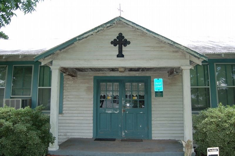
One of the earliest schools
for African-American children
in this rural area
staffed by
Blessed Mother Katharine Drexel's
Sisters of the Blessed Sacrament — — Map (db m236354) HM
• Southwestern Louisiana Industrial
Institute was established July 14, 1898.
State Senator Robert Martin, for
whom the administrative building is
named, authored the legislative act
that created SLII. •
In 1899, the Board of Trustees . . . — — Map (db m227412) HM
• Dr. Edwin L. Stephens, first president of
SLII, planted oak trees on campus on
January 1, 1901. •
The first campus building, known initially
as the Main Building, was completed in June
1901. •
SLII opened on September 18, 1901, with
100 . . . — — Map (db m227415) HM
• The first L'Acadien yearbook was published
in 1912.
• In 1916, SLII became a senior high school
and junior college. •
The Institute's Students Army Training
Corps began in 1918. •
Influenza epidemic closes campus for . . . — — Map (db m227416) HM
•In 1920, the Main Building was renamed
Martin Hall in honor of Louisiana Sen Robert.
Martin, who introduced legislation that created
SLII •
1920 enrollment 280-number of
faculty 26. •
In 1921, SLII became a college and
conferred its first . . . — — Map (db m227419) HM
• 1930 enrollment 918-number of
faculty 58.
• The first Camellia Pageant was held in
1934.
• Dr. Edwin Stephens, first president of
Southwestern Louisiana Institute, retired in
January 1938. He died on November 5, 1938. •
Lether E . . . — — Map (db m229010) HM
• 1940 enrollment 2,345-number of faculty 109. •
In January 1941, Joel Lafayette Fletcher became
the third president of SLI. •
By the end of 1941, SLI had either won or tied for
Louisiana Intercollegiate Conference championships
in . . . — — Map (db m229011) HM
• 1950 enrollment 2,556 - number of
faculty 193. •
In 1954, SLI became the first all-white, state
supported public college in the South to enroll
a black student. It was permanently integrated
in 1956. The first African-American Graduate
was . . . — — Map (db m237097) HM
• SLI became The University of Southwestern
Louisiana on July 27, 1960, •
1960 enrollment 4910-number of
faculty 315. •
USL adopted the nickname "Ragin' Cajuns"
for its athletic teams. •
President Joel L. Fletcher Resigned in
October . . . — — Map (db m237101) HM
• 1970 enrollment 10,275-number of
faculty 539. •
Student Union opened in 1970 and Cajun
Field opened in 1971. •
Clyde R. Rougeou took a one-year leave
of absence in 1973, to be followed by
retirement. •
Ray P. Autherment was named . . . — — Map (db m237205) HM
• 1980 enrollment 13,865 - number of
faculty 565. •
USL began developing University Research
Park. •
University officials helped Acadiana diversify
its economy after the once dominate oil
industry virtually collapsed due to a decline
in . . . — — Map (db m237206) HM
On St. John Street, on the right when traveling south.
Established in 1846. A combination of Mount Carmel Academy and Cathedral School. Operated by The Cathedral of St. John the Evangelist Parish in the Diocese of Lafayette. Affiliated with the Sisters of Our Lady of Mt. Carmel and the De La Salle . . . — — Map (db m49062) HM
On Johnston Street (U.S. 167) at East University Avenue (Business U.S. 90), on the left when traveling south on Johnston Street.
Following its establishment in 1898, Dr. Edwin Lewis Stephens became the University's first president in 1900 at the age of 27. He transformed an empty sugar cane field into a respected institution of higher learning. On January 1, 1901, he planted . . . — — Map (db m111638) HM
On Carmel Drive (State Road 94) 0.3 miles east of Louisiana Avenue, on the left when traveling east.
On July 9, 1913, Father Keller purchased farm land once owned
by the sister of the King of
France, from Louis Domengeaux to
establish Holy Rosary Institute in Lafayette, Louisiana.
The Institute opened September 1913 as an industrial . . . — — Map (db m120896) HM
The stadium that once stood near this site was named for Clement
James McNaspy. He was the school's first athletic director and coach,
in addition to his duties as a physics and chemistry professor. He was
known as the "Father of Southwestern . . . — — Map (db m238262) HM
Near East Pinhook Road at SW Evangeline Thruway (U.S. 90).
These centurion live oak trees shaded Ile Copal, the plantation home of Alexandre Mouton. Mouton was governor of Louisiana from 1843-46 and son of the founder of Vermilionville. Here marks the beginning of a shady lane of oaks planted by Emma K. . . . — — Map (db m125837) HM
On September 15, 1953, Clara Dell Constantine, Martha Jane Conway, Charles Vincent Singleton, and Shirley Taylor attempted to enroll at Southwestern Louisiana Institute, now known as the University of Louisiana at Lafayette. They were denied, due to . . . — — Map (db m66243) HM
Near Fisher Road near Surrey Street (State Road 728-8).
School House: Banning of the French Language
L'école is a reproduction of a typical schoolhouse of the late 1800s. In southwest
Louisiana, French was the dominant language until the mid-1900s. Native Americans
along with . . . — — Map (db m135004) HM
On Rex Street at East St. Mary Boulevard, on the right when traveling west on Rex Street.
After four black students successfully sued in federal court to gain admission, Southwestern
Louisiana Institute, now the University of Louisiana at Lafayette, became the first state-supported,
previously all-white undergraduate college in the . . . — — Map (db m224481) HM
On Rex Street at East St. Mary Boulevard on Rex Street.
This marker commemorates the 50th anniversary of the desegregation of Southwestern
Louisiana Institute and the 50th anniversary of Brown v. the Board of Education of Topeka,
Kansas, the landmark Supreme Court case that ultimately resulted in the . . . — — Map (db m224616) HM
On General Gardner Avenue east of General Mouton Avenue, on the right when traveling east.
Architectural Style: American Foursquare
This house is a stately, two-story, central-hall residence designed
In the American Foursquare style incorporating elements of
the Prairie School and Craftsman styles. The style was popular
In the U.S. . . . — — Map (db m236705) HM
On South Bayou Drive (State Highway 1) 0.1 miles south of Jacob Drive, on the right when traveling south.
Built in 1931, this was the first brick school in Lower Lafourche. Earlier students had to attend high school in Cut Off or Larose. Its importance as an educational institution is immeasurable. Many political careers were launched on its steps. — — Map (db m92871) HM
Near State Highway 307 south of Torres Road, on the right when traveling south.
On March 27th, 2004, the Bayou Boeuf Elementary
"Little Red School House” celebrated its 100th year of
service and was named the "Denise C. Borne
Memorial School House” in honor of Mrs. Borne's
lifelong commitment to public . . . — — Map (db m128903) HM
On State Highway 307 south of Torres Road, on the right when traveling south.
In 1983, the State Dept. of Education recognized Bayou Boeuf Elementary's "Little Red School House" as the oldest one-room school house in continuous use in LA. Est. in 1904, building housed grades 1-7. Moved from its original location near the . . . — — Map (db m85470) HM
On State Highway 308, 0.1 miles west of Peltier Drive, on the right when traveling west.
The school was built by local people on land donated by Sylvestre Baudoin and Fergus Foret. It's first teachers were Ida Foret and Winnie Pittman. Other teachers were Edna Ledet, Anita Knoblach, Louise Sevin and Lillian Scott. They taught local . . . — — Map (db m81066) HM
On Iris Street east of Ledet Street, on the right when traveling east.
C.M. Washington High School, the
first public high school for African-
American students in Thibodaux,
was dedicated on December 18, 1950.
The school included grades 1-12. It
was named for Cordelia Mathews
Washington, a pioneer and leader . . . — — Map (db m232107) HM
On East Bayou Road (State Highway 308) 0.1 miles Rienzi Drive, on the right when traveling west.
This house is believed to have been built by William Fields or Henry Johnson between 1815 and 1835 Johnson eventually purchased several small tracts to form the huge sugar-producing plantation. Other significant owners were Henry Schuyler Thibodaux, . . . — — Map (db m81072) HM
On East 1st Street (State Highway `) at St. Charles Street, on the right when traveling east on East 1st Street.
In 1855, Father Charles M. Menard,
venerable pastor of St. Joseph Church,
foreseeing the need for Catholic education
of Thibodaux youth, purchased land and built
a school for girls on this site.
The Sisters of Mt. Carmel bought the . . . — — Map (db m81069) HM
On Legends Avenue (State Highway 149) just south of Interstate 20, on the left when traveling south.
Mr. A.D. Smith, Sr., was a beloved educator, civic, religious
and political leader. In 1939, he began a teaching career
in Bienville Parish that spanned thirty-one years, including
serving as the first Principal of the GSU Laboratory School,
and . . . — — Map (db m157217) HM
On Legends Avenue (State Highway 149) 0.3 miles south of Interstate 20, on the left when traveling south.
In 1901, the North Louisiana Colored
Farmers Relief Association asked the
Tuskegee Institute's Booker T. Washington to
find a man capable of setting up an agricultural
and industrial school in North Louisiana.
Charles P Adams was that man. . . . — — Map (db m160083) HM
Near Legends Avenue (State Highway 149) 0.3 miles south of Interstate 20, on the left when traveling south.
Conrad Hutchinson Jr. arrived in Grambling
in 1952 and had a plan to make the Grambling
College Marching Band the "Best Band In the
Land". It didn't happen overnight and it certainly
wasn't easy, but "Hutch” and his staff began
molding . . . — — Map (db m160008) HM
Near Legends Avenue (Highway 149) 0.3 miles south of Interstate 20, on the left when traveling south.
Dr. Alice Brown Smith began her career in the
Grambling College teacher education program in 1957,
after serving as a Jeanes Supervisor for over ten years
in Mississippi, a special class of Black educators in the
South. At Grambling, she . . . — — Map (db m158528) HM
Near Legends Avenue (State Highway 149) 0.3 miles south of Interstate 20, on the left when traveling south.
A.D.'s career as a Grambling City Alderman, community
leader, teacher, & educational admin. spanned 40 years.
He was elected City Councilman in 1985, following in the
footsteps of his father, A.D. Smith Sr. Later, like his father, he
became . . . — — Map (db m160421) HM
Near Legends Avnue, 0.3 miles south of Interstate 20, on the left when traveling south.
Dr. Earl Lester Cole was a man of enormous integrity and
credibility who devoted his entire professional career to
Grambling State University spanning nearly half a century,
and he also contributed much to the growth of the
Grambling community. . . . — — Map (db m151942) HM
Near Legends Avenue (State Highway 149) 0.3 miles south of Interstate 20, on the left when traveling south.
Dr. Johnson was the 3rd president of Grambling State
Univ. In the span of 14 years, he brought a new dimension
of progress & enhancement to the university, with a 10-point
plan for improvement. He stabilized & doubled enrollment,
strengthened . . . — — Map (db m150974) HM
Near Legends Avenue (State Highway 149) 0.3 miles south of Interstate 20, on the left when traveling south.
Dr. Leon Whittaker had a distinguished career in
Education, produced scholarly and Christian writings,
and was known for his expertise in Career Counseling
and Placement, Dean of Students, Vice President of
Student Affairs, Interim Dean of . . . — — Map (db m158529) HM
Near Legends Drive (State Highway 149) 0.3 miles south of Interstate 20, on the left when traveling south.
Henry Louis Dyer (born in Baton Rouge, LA) is a
former Grambling College All-American, as well as,
American football running back in the National Football
League for the Los Angeles Rams and the Washington
Redskins. He was Grambling's leading . . . — — Map (db m159016) HM
On Legends Avenue, 0.3 miles south of Interstate 20, on the right when traveling south.
LaFayette Fate Richmond was born in 1864
& led the establishment of the North Louisiana
Colored Agricultural Relief Association. The
goal was to promote economic self-sufficiency
for African Americans and racial uplift through
Vocational . . . — — Map (db m150375) HM
On Bennett Road at W Martin Luther King Jr Avenue (State Highway 150), on the right when traveling north on Bennett Road.
In 1882 sixteen churches met at Liberty Hill Baptist Church in Knowles, Louisiana about three miles north of Grambling to establish the Liberty Hill Baptist Association, an organization of churches in north-central Louisiana. The Association brought . . . — — Map (db m234403) HM
On Igoe Inn Road (Parish Route 32) at Railroad Drive, on the right when traveling south on Igoe Inn Road.
Founded in 1906 by T. A. Howard, I. W. Howell, L. W. Perry, Horace Williams, W. A. Garner, B. A. Howell, J. A. Douglass, E. M. Howell, J. S. Johnson & C. H. Land. Summer programs for education and cultural interests. Declined after the local college . . . — — Map (db m234404) HM
Near Legends Avenue (State Highway 149) 0.3 miles south of Interstate 20, on the right when traveling south.
Mrs. Ruby Lee Weekly Billups, a native of Vidalia, LA,
arrived on the campus of Grambling College on
September 10, 1947. Her employment in the Registrar's
Office began her freshman year. She graduated magna
cum laude with a B.S. degree in . . . — — Map (db m159403) HM
Near Legends Avenue south of Interstate 20, on the left when traveling south.
R.W.E Jones, affectionately known as "Prez", was
President of Grambling State University from 1936
until his retirement in 1977. He was the second
president of the historically black university.
Jones began his career at Grambling . . . — — Map (db m150362) HM
Near Legends Avenue (State Highway 149) 0.3 miles south of Interstate 20, on the left when traveling south.
Mrs. Rosetta Days began her career as an educator in
Webster Parish in the fields of language arts, social
studies, & adult education. At Grambling State University,
she was an Assistant Professor, Academic Counselor, and
Director of the High . . . — — Map (db m160419) HM
Near Legends Avenue (State Highway 149) 0.3 miles south of Interstate 20, on the left when traveling south.
Sarah Jane Richmond, born in 1869, was appointed as
Grambling's first Postmistress on April 16, 1907, a post
she held for four years. She was also a founding
member of Grambling's first Chapter of the Order of
Eastern Star in 1944. Sarah's . . . — — Map (db m159071) HM
On Legends Avenue (Highway 149) 0.3 miles south of Interstate 20, on the left when traveling south.
Mr. Siscro McCarty was an educator who came to
Lincoln Parish in the 1960s. He earned his way through
the ranks until he became Assistant Principal.of Ruston
High School, Principal of Ruston Junior High School &
finally, Supervisor of Student . . . — — Map (db m160418) HM
On Arlington Street just north of Hart Avenue, on the right when traveling south.
In 1885, a school was established to provide Negro citizens an education in Ruston, Louisiana and was chartered in 1891. In 1892, the Ruston Normal Colored High School started. The school was destroyed by fire. In 1924-1925, it was rebuilt in the . . . — — Map (db m237163) HM
On North Trenton Street (U.S. 63/167) south of Toma Lodge Drive, on the left when traveling north.
Chosen in 1889 as site for the Louisiana Chautauqua Society's Summer Program of education for teachers and culture for all. It flourished from 1891 to 1905. Many famous speakers lectured here. Forerunner of Louisiana Tech University. — — Map (db m221102) HM
On West Madison Avenue at West Hickory Avenue, on the right when traveling east on West Madison Avenue.
Site of first school built for Morehouse Parish blacks. Built 1916 through efforts of parish school board and several Bastrop blacks. Subsequent buildings housed Morehouse High School until 1969. — — Map (db m109319) HM
On 2nd Street at University Parkway (State Highway 6), on the left when traveling south on 2nd Street.
The history of Northwestern State University begins when a portion of property owned by Natchitoches founder Louis Juchereau de St. Denis was obtained by the Bullard family who in 1832 completed a mansion on a hill facing east towards Chaplin’s . . . — — Map (db m106519) HM
Panel 2 Although the Boswell Sisters will forever be associated with New
Orleans,-they were born elsewhere. Martha and Constance were
born in Kansas City, Missouri, and Helvetia was born in
Birmingham, Alabama. Their father, who had been in . . . — — Map (db m189157) HM
On Newcomb Circle near Newcomb Place, on the right.
Founded 1886 as the Coordinate Women's College of Tulane University by Josephine Louise Le Mommier Newcomb (1816-1901) in memory of her daughter Harriott Sophie Newcomb (1855-1870).Originally located in the former Thomas Hale House at Camp Street . . . — — Map (db m114187) HM
On Newcomb Place at Newcomb Circle, on the right when traveling south on Newcomb Place.
The Newcomb Pottery Garden honors the artistic legacy of Newcomb Pottery, a quasi-commercial enterprise established in the late 19th century in association with the curriculum of Newcomb College...During its forty-five years in existence, the . . . — — Map (db m114188) HM
On Canal Street at Decatur/Magazine Street, on the right when traveling west on Canal Street.
United States Customhouse Has been designated a National Historic Landmark This site possesses national significance in commemorating the history of the United States of America — — Map (db m28113) HM
On Terpsichore Street near Robert C. Blakes Sr. Drive, on the left when traveling north.
Henry Roeland Byrd "Professor Longhair" (1918-1980), pianist, composer, and singer, lived here at 1738-40 Terpsichore from 1979 until his death. In the 1950’s he recorded several singles including “Bald Head”, "Big Chief", . . . — — Map (db m163869) HM
On Pauline Street east of North Galvez Street, on the left when traveling west.
On these grounds on November 14,
1960, one child took a step
to desegregate William Frantz Public
School, an act which changed the face
Of education across the country.
This monument is dedicated to all the
children whose extraordinary . . . — — Map (db m204387) HM
On this site Father Raphael de Luxembourg Capuchin Pastor of the parish Church of St. Louis (later the Cathedral) opened the first school in French Colonial Louisiana. Classes in reading, writing, music, French, Latin and religion were conducted for . . . — — Map (db m51321) HM
Malcolm Woldenberg, one of Louisiana’s greatest philanthropists of the 20th century, dedicated his wealth to helping local, national, and international charities in aid of the elderly, children’s health, education, the worldwide Jewish community, . . . — — Map (db m51288) HM
The design of this post-Civil War mansion of a prominent Louisiana sugar planter, attributed to James Freret, architect, reflects the influence of the French “Ecole des Beaux Arts,” where he studied from 1860 to 1862. Residence of Walter . . . — — Map (db m51519) HM
On Fourth Street north of Camp Street, on the left when traveling north.
Built in 1856-57 for Bernard and C. Felicie Kock by Robert Little and Peter Middlemiss In 1899, Josephine Louise Le Monnier Newcomb, benefactress of the H. Sophie
Newcomb Memorial College, purchased this house as her residence. From her death
in . . . — — Map (db m210966) HM
On Elysian Fields Avenue at Stephen Girard Street, in the median on Elysian Fields Avenue.
Since 1869 the Brothers and their colleagues have touched the hearts and shaped the lives of the City's youth. As St. Aloysius in the Vieux Carre, Cor Jesu on this site and, since merging in 1969 into Brother Martin High School, belief in God, love . . . — — Map (db m97461) HM
On Chef Menteur Highway (U.S. 90) near Providence Place.
First envisioned by the Southern Baptist
Convention at its formation in 1845,
Baptist Bible Institute was created in
1917 by direct vote of the Convention to
train ministers and missionaries to carry
out the Great Commission (Mt. . . . — — Map (db m213115) HM
On Saint Claude Avenue (State Highway 46) east of Alabo Street, in the median.
Civil Rights Pioneers On November 14, 1960, four six-year-old children in New Orleans became the first African-Americans to integrate "white only" public elementary schools in the Deep South. On that day, three girls enrolled in McDonogh No. 19 . . . — — Map (db m99584) HM
Near North Claiborne Avenue just north of Iberville Street, on the right when traveling north.
"My name is Marie Justine Cirnaire. I was born in Guinea.
When I was
perhaps seven years of age I was carried to St. Dominique. I am as a result
not aware of the name of my father nor of my mother, nor do I know my age.
I was . . . — — Map (db m161741) HM
Near North Claiborne Avenue just north of Iberville Street, on the right when traveling north.
Pioneers in education and in the care of orphans and the
elderly among the colored people, this society of colored
sisters was founded in New Orleans on November 21, 1842 by
misses Henriette Delille and Juliette Gaudin who became the first and . . . — — Map (db m161740) HM
On St. Claude Avenue west of Gordon Street, on the right when traveling west.
On November 14, 1960, three six-year-old girls-Leona Tate, Tessie Prevost and Gail Etienne-
integrated McDonogh 19. Known as the "McDonogh Three,” they were escorted every day
by U.S. Marshalls, and were the only students to attend the school for . . . — — Map (db m204470) HM
On Canal Street west of North Gayoso Street, in the median.
Boys' Central High School was founded in 1843, relocated to this site in 1913 and was renamed Warren Easton Boys' High School in honor of the superintendent of New Orleans public schools, 1888-1910. The building was designed by E.A. Christy, noted . . . — — Map (db m95879) HM
"This residence and grounds are named in honor of Marvin E. Thames, Ph.D., who served this college in the following manner: Director of Isaac Delgado Trades School from 1954 to 1958; Dean and President of Delgado Trades and Technical Institute from . . . — — Map (db m86198) HM
On City Park Avenue at North Anthony Street, on the right when traveling west on City Park Avenue.
On this site between August 1941 and August 1945, the City Park Plant of Higgins Industries, Incorporated mass produced more than 12,000 landing craft and approximately 200 PT boats for the Allied Forces. The Higgins landing boats revolutionized . . . — — Map (db m87552) HM
On North Miro Street at Anette Street, on the left when traveling east on North Miro Street.
Fannie C Williams Pioneer in Public EducationAs one of New Orleans' premier educators in the first half of the twentieth century, Fannie C. Williams steered this school through decades of challenge and change. An active civic leader, she was . . . — — Map (db m115964) HM
On Esplanade Avenue north of North Rampart Street, on the right when traveling north.
Founded in 1869 by the Brothers of the Sacred Heart on Chartres Street in the Vieux Carré, St. Aloysius College moved in 1892 to a building on Rampart Street, then in 1925 to a new building at the corner of Esplanade Avenue and Rampart Street, St. . . . — — Map (db m102859) HM
On North Galvez Street west of Alvar Street, on the right when traveling west.
William T. Frantz Elementary School at 3811 North Galvez Street in New Orleans became a significant site in the Civil Rights Movement of the 1960s. On November 14, 1960, a six-year-old girl walked through its doors and changed the course of . . . — — Map (db m202739) HM
On Milan Street near Chestnut Street, on the right when traveling north.
W.A. Freret, Architect J.C. Kiddell, Builder Dedicated October 22, 1877 Erected from funds bequeathed to the City of New Orleans in the will of John McDonogh, in continuous use as a public elementary school for one hundred years.This plaque is . . . — — Map (db m155704) HM
On Esplanade Avenue at North Derbigny Street, in the median on Esplanade Avenue.
In 1869, the American Missionary Association (AMA) and philanthropist Seymour Straight partnered to found Straight University, a school where African Americans could aspire to the highest education available after Emancipation. Classes were first . . . — — Map (db m213943) HM
On St. Charles Avenue west of Jena Street, on the right when traveling west.
The Academy of the Sacred Heart was founded in 1887. It has continued to serve as a Catholic, independent, college preparatory school for girls, offering 15 years of instruction from nursery school through high school. The Rosary, as Sacred Heart is . . . — — Map (db m95686) HM
On St. Charles Avenue at Valmont Street, on the right when traveling east on St. Charles Avenue.
5318 St. Charles Avenue
The site of Gilbert Academy
and
New Orleans University,
Black Educational
Institutions
Under the auspices of
The Methodist Church
1873 to 1949 — — Map (db m12678) HM
Jack Hayes -
1882-1961 / Ann Stapp Hayes -
1885-1972 Mr. Jack Hayes, principal of Ouachita Parish High School for forty-one
years, 1908-1949, was beloved and respected by thousands of students who
came under his able leadership.
Recognized . . . — — Map (db m244326) HM
The proud tradition of the Ouachita Parish High School,
O.P.H.S. was established during the forty-one year tenure
1908-1949 of its beloved principal, Henry Elmo Jack Hayes.
Established in 1894 by the school board, the high school
first . . . — — Map (db m244384) HM
On State Highway 39, on the right when traveling north.
Woodlawn High School was built at this site in 1950
and is historically significant at the national level
for its association with the struggle to end racial
segregation in public schools during the 1960s.
Woodlawn was originally intended to . . . — — Map (db m205918) HM
On State Highway 419, 0.9 miles east of State Highway 972, on the right when traveling east.
Lt. General Lejeune, 1867-1942, was born in Innis; commanded the 2nd Division of the AEF during WW I; became Commandant of USMC; was superintendent of VMI from 1929 to 1937. — — Map (db m94436) HM
On Washington Street at 5th Street, on the right when traveling north on Washington Street.
This site, located in the town's center square, was set aside for public use on the original town plat commissioned by Alexander Fulton in 1805. The building was constructed solely for advancement of culture and learning in 1907 by Caldwell . . . — — Map (db m38292) HM
On Water Tower Drive south of Middleton Drive, on the right when traveling north.
Completed in 1852 and owned by Edwin Epps, a former overseer of Oakland Plantation, the Edwin Epps House is located where LSU Alexandria stands today. This single story Creole cottage was originally built on Bayou Boeuf near Holmesville in Avoyelles . . . — — Map (db m116044) HM
Near Middleton Road east of West Campus Avenue, on the left when traveling east.
In late February 1961, the LSU Board of Supervisors chose a name for the first new permanent building to be constructed on the campus, selecting Oakland Hall in honor of Oakland Plantation, the land on which the campus was located.Construction . . . — — Map (db m116005) HM
On 3rd Street north of Johnston Street, on the left when traveling south.
Side A After having been ravaged by fire during the Civil War, Alexandria was rebuilt and, with the building of railroads after Reconstruction, regained its place as the commercial, financial, medical and transportation center of central . . . — — Map (db m38287) HM
On 3rd Street south of Murray Street, on the left when traveling south.
Side No. 1 On this site in 1906, the City Library known as the Manning Memorial Library was opened, named in honor of a 19th century resident who served his State and his Nation. Hundreds of his personal volumes were donated to this library, . . . — — Map (db m38291) HM
On Veterans Drive west of Canal Street, on the right when traveling west.
Built in 1924, the Lecompte High School is a significant historic landmark of Bayou Boeuf. It's Neo-Classical style was designed by architect Scott Yeager, Jr., built by general contractor W. J. Quick. Lecompte High served the educational needs of . . . — — Map (db m124011) HM
On Shreveport Highway (U.S. 71) south of Rigolette Road (State Road 1203), on the left when traveling south.
1860 The Louisiana State Seminary of Learning and Military Academy, the predecessor of the Louisiana State University, opened at this site in January 1860 with Colonel William Techmseh Sherman as its first superintendent, five faculty . . . — — Map (db m111560) HM
On Allen Drive, 0.1 miles east of College Drive, on the right when traveling north.
For a century and among generations of alumni, this iconic academic building has
symbolized Louisiana College. When the future of the college remained in doubt
following a destructive fire, the people of Alexandria, Louisiana came forward . . . — — Map (db m174653) HM
On Shreveport Highway (U.S. 71) south of Rigolette Road (State Road 1203), on the left when traveling south.
Life at the Seminary offered few distractions and fewer luxuries to either the faculty or the cadets. Fresh produce and meat were not available, but despite the poor food, students left the Seminary in better physical condition than when they . . . — — Map (db m111169) HM
On College Boulevard south of Main Street (Business U.S. 165), on the right when traveling north.
The Cavanaugh Hall of Science bears the name of Charles J. Cavanaugh, whose
teaching career spanned 1945 to 1977 as professor of biology at his alma mater,
Louisiana College. Prof Cavanaugh, as he was affectionately known, often
lectured without . . . — — Map (db m136036) HM
Near Shreveport Highway (U.S. 71) south of Rigolette Road (State Road 1203), on the right when traveling north.
William Tecumseh Sherman, a graduate of West Point, was appointed the fist superintendent and a professor of engineering of the Louisiana Seminary of Learning & Military Academy. In June of that year, General G. Mason Graham wrote to Major D.C. . . . — — Map (db m111061) HM
On Allen Drive south of College Drive, on the right when traveling east.
The roots of Louisiana College extend to schools at Mount Lebanon (Bienville Parish) and Keachie (DeSoto Parish), founded in the 1850's by north Louisiana Baptists. By the end of the nineteenth century the Louisiana Baptist Convention (LBC) assumed . . . — — Map (db m110635) HM
On Shreveport Highway (U.S. 71) south of Rigolette Road (State Road 1203), on the right when traveling north.
Provided for by Constitution of 1845 with funds from fed. land grants. Opened, 1860; closed during Civil War; reopened, 1865. Burned 1869; moved to Institute for Deaf, Dumb, and Blind, Baton Rouge. Became Louisiana State University, 1870. — — Map (db m110942) HM
On Shreveport Highway (U.S. 71) at Rigolette Road (State Road 1203), on the right when traveling north on Shreveport Highway.
Louisiana acquired the land on this site as the location of the Seminary of Learning of the State of Louisiana in 1853. George Mason Graham from nearby Bayou Rapides chaired the Board of Trustees appointed to construct a building and determine the . . . — — Map (db m136033) HM
Near Shreveport Highway (U.S. 71) south of Rigolette Road (State Road 1203), on the left when traveling south.
Location The site selected for the location of the Seminary building was on a hill in an opening of the pine woods north of the Red River, within four miles of the city of Alexandria, Louisiana.Building Description The main building . . . — — Map (db m111163) HM
Near Shreveport Highway (U.S. 71) 0.3 miles north of Executive Court, on the right when traveling north.
This Stone Was A Part Of The 1st LA. Seminary Built A.D. 1859 And marks the original site Destroyed by fire in 1869 Placed by The Colonial Dames Of Alexandria June 1926 — — Map (db m110805) HM
On Cotton Street at Martin Luther King Street (State Highway 3048), on the left when traveling west on Cotton Street.
Founded in 1904, initially known as "The
College.” Approved as a junior high in 1933.
Became Rayville Colored School in 1936.
Graduated first students in 1939 as a high
school. Renamed Rayville Rosenwald High
School in 1949. Became Eula D. . . . — — Map (db m209552) HM