On McLemore Drive south of East College Street, on the left when traveling south.
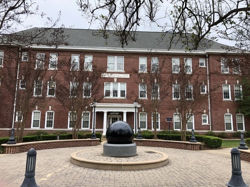
Jennings Hall was among the finest college dormitories in the South when the Mississippi College landmark opened in 1908. Heated with steam, every room had its own electric light and bathroom. “Jennings Girls” lived four to a room during post World . . . — — Map (db m219711) HM
On Jefferson Street at West Main Street, on the right when traveling south on Jefferson Street.
Tanglewood was originally built ca. 1845 on Norrell Road, then just south of Clinton, by Andrew and Nancy Thomas for their daughter Mary Jane and her husband, James A. Criddle. By 1876 Tanglewood had come into the ownership of Captain William Lewis . . . — — Map (db m89730) HM
On East College Street east of Landrum Street, on the left when traveling east.
Built ca. 1835, this Greek Revival house is one of the oldest in Hinds Co. U.S. Grant passed by enroute to Civil War siege of V'burg, 1863. This structure is listed on the National Register of Historic Places. — — Map (db m115290) HM
On Adams Lane near State Route 467, on the left when traveling south.
What you see here is a reconstruction of the 1852
house built by the Cokers. Efforts to fully restore
the original house were not successful. In order to
save the structure, the house was dismantled and
the salvaged materials were used in the . . . — — Map (db m110131) HM
Near Commerce Street west of South Jefferson Street.
History of the
GM&O Depot
Known at the date of its closing as the GM&O Depot, this passenger depot was constructed in 1927 by the New Orleans Great Northern Railroad (NOGN) and later served the Gulf, Mobile & Northern Railroad (GM&N) as . . . — — Map (db m115146) HM
Built 1846-47 by slave labor, of handmade brick. Original cost $7,505.58. John Oldham, Mayor - Will Gibbon, Arch. Used as hospital for both Union and Confederate soldiers during War Between the States, this building was spared when the town, having . . . — — Map (db m49682) HM
On North Jefferson Street, 0.1 miles south of Boyd Street, on the right when traveling south.
Built ca. 1853 for James H. Boyd, Mayor of Jackson, 1842, 1844, 1850, and 1858. One of the few homes to survive the Civil War, the Greek Revival house is listed on National Register of Historic Places. — — Map (db m115286) HM
On Fairview Street, 0.1 miles east of North State Street (U.S. 51), on the left when traveling east.
Built ca. 1908 as a private residence for
Cyrus C. Warren, vice president of the
Warren-Godwin Lumber Company, this
Colonial Revival mansion was designed
by the Chicago architectural firm of
Spencer & Powers. Known as the Warren-
Gunter . . . — — Map (db m115367) HM
Near East Fortification Street at North Jefferson Street.
The Jitney Jungle grocery store chain was
founded in 1919 by the McCarty and Holman
families. In 1933, Jitney No. 14 held its
grand opening in this Tudor Revival
building designed by Emmett Hull. The
building, called "The English Village," . . . — — Map (db m115335) HM
On North State Street (U.S. 51) north of Arlington Street, on the left when traveling north.
This Georgian Revival home was designed by architect Bem Price and built by Isaac C. Garber in 1913, for Mary D. (Terrell) and Thad B. Lampton, prominent businessman and banker who served as the state treasurer under Governor Longino. The estate . . . — — Map (db m133854) HM
On Fortification Street at North West Street, on the right when traveling west on Fortification Street.
Built in 1857 by Charles Henry Manship,
the Manship House is an excellent example
of a Gothic Revival “cottage villa" inspired
by A.J. Downing's The Architecture of
Country Houses. Manship (1812-1895) was
the mayor of Jackson during the Civil . . . — — Map (db m178427) HM
On Poplar Boulevard at Hazel Street, on the right when traveling west on Poplar Boulevard.
This building was once Belhaven's own full service gas station and general store, nicknamed by residents the "Shady Nook." It was originally built as a one-room structure ca. 1928 and then expanded in 1936 by architect A. Hays Town using . . . — — Map (db m133852) HM
On St Mary Street at Pinehurst Street, on the right when traveling north on St Mary Street.
Front
In 1928, Jackson developer Lucius L. Mayes converted six acres of rugged terrain into a residential development of fully furnished, up-to-date homes with similar color schemes but in a variety of architectural styles. A grand . . . — — Map (db m133850) HM
On W. Main Street (State Highway 467) at Oak Street, on the right when traveling west on W. Main Street.
St. Mark’s was organized in 1837 by Rev. James McGregor Dale and construction of the sanctuary was completed in 1855. Following the battle of Raymond on May 12, 1863, the church was used as a hospital for Federal soldiers. The interior of the church . . . — — Map (db m115932) HM
On West Main Street (Mississippi Route 467) at Port Gibson Street, on the right when traveling west on West Main Street.
Waverly, or the Peyton house, is located on the historic Natchez Trace, the main road from Raymond to Clinton. Waverly was constructed from 1831-34, and in 1863 was used as the headquarters of Maj. Gen. James B. McPherson after the Battle of Raymond . . . — — Map (db m219687) HM
On South Cummings Street north of West Mattox Street, on the right when traveling north.
The Fulton Grammar School was designed by architect J.B. Lawson and built with Work Projects Administration assistance in 1939. This one-story brick building of nineteen rooms included a library, music room, kindergarten, office, and a 550-seat . . . — — Map (db m102622) HM
On East Main Street, 0.1 miles east of South Rose Street, on the right when traveling east.
Also known as the Cates-Gaither House, this one-story Greek Revival-style planters cottage was built in ca. 1859 by ship builder and merchant Pleasant Cates. The heavy framing includes original pegged joints. Named for the cedar trees on the . . . — — Map (db m96773) HM
On Italian Isle Road at Wind Drift Lane, on the right when traveling east on Italian Isle Road. Reported missing.
Built ca. 1899 by S.W. and Elizabeth Henderson Labrot. Labrot was superintendent of the L&N Railroad Creosote Plant. In 1902, the Labrots sold the house to the Louisville and Nashville Railroad Company. The style of construction, using vertical . . . — — Map (db m243013) HM
On State Street south of Robinson Street, on the right when traveling north.
Built in 1906-07 by African American
William Louis Carter, this vernacular Queen
Anne style house features an unusual
exterior shape. It is popularly known as the
"Steamboat House” because its shape suggests
the outline of a ship, with a . . . — — Map (db m197302) HM
On East Beach Drive east of Holcomb Boulevard, on the left when traveling east.
Designed in 1890 by Chicago architect Louis Sullivan (known as the "Father of the Skyscraper") and his young draftsman, Frank Lloyd Wright, this was the vacation home of James Charnley and later Fredrick Norwood, both Chicago lumber magnates. The . . . — — Map (db m109201) HM
On Frederic Street at Orange Avenue, on the right when traveling south on Frederic Street.
The Orange Avenue Historic District includes nineteen architecturally significant structures on Orange and Live Oak Avenues and Frederic and Magnolia Streets. Five of the homes in the area are independently listed in the National Register of . . . — — Map (db m122478) HM
On Denny Avenue (U.S. 90) at Pascagoula Street, on the right when traveling west on Denny Avenue.
The Pascagoula Ice and Freezer Company
was established in the late 1880s. Its
name changed in 1903 when the one-story
brick building just north of this site
was built. It is the only example of
Mission Revival Style architecture in
Pascagoula . . . — — Map (db m102184) HM
On Anderson Street at North Deason Street, on the left when traveling west on Anderson Street.
This one-story, Greek Revival-style house was constructed ca. 1847 with a wood façade shaped to resemble stone blocks and a hexagon-shaped entrance vestibule. On October 5, 1863 Confederate Major Amos McLemore, who had been sent to the area to round . . . — — Map (db m73449) HM
On Hill Street at Calhoun Street, on the right when traveling south on Hill Street.
Jones County was established in 1826 with two county seats, Ellisville and Laurel. This courthouse was designed by architect Penn Jeffries (P.J.) Krouse and constructed by Norris and Gardner in 1908, with the Laurel courthouse in 1908, as its twin. . . . — — Map (db m111002) HM
On Hal Crocker Road at U.S. 29, on the right when traveling west on Hal Crocker Road.
Newt Knight: Robin Hood or Renegade?
On October 5, 1863, Major McLemore sat in front of the fire in the comfortable home of Amos Deason. He had been sent from Atlanta to round up a growing number of deserters who hid out in the swamps of . . . — — Map (db m129103) HM
On North 5th Avenue (Mississippi Route 537) south of West 5th Street, on the right when traveling north.
This property has been
placed on the
National Register
of Historic Places
by the United States
Department of the Interior
Circa 1907 — — Map (db m126691) HM
On North 5th Avenue at Yates Avenue, on the right when traveling north on North 5th Avenue.
Opened on November 24, 1914, this building once housed all of Laurel's city officials, as well as the fire and police departments. Laurel City Hall was designed by architect Penn Jeffries Krouse and is an early example of the eclectic Mediterranean . . . — — Map (db m110979) HM
On Murray Street, 0.1 miles west of Ridgewood Manor Drive.
Cedar Oaks was built ca. 1857
by architect and builder William
Turner. After surviving the Union
occupation of Oxford during the
Civil War, the house was moved
to this site in 1963 by local
clubwomen after the house was
threatened by . . . — — Map (db m219924) HM
On Courthouse Square west of North Lamar Boulevard, on the right when traveling west.
Site of the
drug store and medical office
of Dr. Thomas Dudley Isom
Considered to be the first white settler
of this region
Building circa 1889 – restored 1988
The Oxford Courthouse Square Historic District
National Register . . . — — Map (db m219916) HM
On South Lamar Boulevard south of University Avenue (Mississippi Route 6), on the right when traveling south.
Built in 1931 as the home
of Murry and Maud Falkner,
the parents of Nobel Prize
winning author William
Faulkner. The house stands
on land purchased in 1898
by J.W.T. Falkner, William
Faulkner's grandfather. — — Map (db m219909) HM
On Van Buren Avenue east of South 6th Street, on the left when traveling east.
An example of Carpenter Gothic
architecture, this house was
designed and built ca. 1872 by
Swedish immigrant G.M. Torgerson,
who designed numerous buildings
in Oxford. In 1939, the house was
purchased by Theora Hamblett
(1895-1977), a . . . — — Map (db m219922) HM
On Victory Hill Lane at Molly Barr Road, on the left when traveling north on Victory Hill Lane.
Twenty-one houses in Community Green
were originally located on the University
of Mississippi campus. Seventeen were
built as early as 1939 using Public
Works Administration funds. The first
African American sorority on campus,
the Theta Psi . . . — — Map (db m219918) HM
One of sixteen buildings built with funds from a special appropriation in 1928, Guyton Hall housed the student health center and the two-year medical school from 1934 until 1955, when the medical school was expanded into a four-year program and . . . — — Map (db m219891) HM
On University Circle, 0.2 miles west of Grove Loop, on the right when traveling west.
Constructed in 1889 at a cost of $35,000, this Romanesque Revival-style building served as the University's first library. Renamed in honor of James Alexander Ventress in 1985, this building has also served as the School of Law (1911-1929), State . . . — — Map (db m102677) HM
On 23rd Avenue at 20th Street, on the right when traveling south on 23rd Avenue. Reported missing.
This Tudor Revival home built in 1923, was the home of Dr. William Jefferson Anderson, founder of the Jeff Anderson Regional Medical Center. Remaining in family hands from his death in 1951 until 1992, the house was purchased in 2001 by the United . . . — — Map (db m111060) HM
On 24th Avenue south of 20th Street, on the right when traveling south.
A native of Meridian, Lewis Crook (1898-1967) moved to Atlanta, Georgia, in 1915 to attend Georgia Tech. Crook began his career with the architectural firm of Hentz, Reid and Adler. In 1923, Crook formed his own firm with business partner Daniel . . . — — Map (db m111123) HM
Built: 1889
Architect: Gustavus Maurice Torgenson
Constructor: C.M. Rubush
Architectural Style: Romanesque
Designated a Mississippi Landmark on June 12, 2002
Listed on the National Register of Historic Places as a contributing . . . — — Map (db m111176) HM
On East Main Street at North 2nd Street, on the right when traveling west on East Main Street.
Built circa 192, 102 East Main Street was the first brick store building in Baldwyn operated by Jones, Pyle, Haney and McDonald as Baldwyn Dry Goods stores. Barber and Beauty Shop located in the basement. Renovated in 2011 by Farmers and Merchants . . . — — Map (db m155373) HM
On West Main Street west of North 2nd Street, on the left when traveling west.
20th century commercial building constructed in 1918 by Nick Waters and Oscar Abrams as a two-story furniture and casket store; became McWhorter Hardware in 1921; later a John Deere dealership and then the General Electric Store opened by Bryson and . . . — — Map (db m155357) HM
On East Main Street near Front Street North, on the right when traveling west.
Late Victorian architecture built in 1910 by Ben Caldwell and operated as McCarthy Hardward store for over 30 years. Converted to a fabric shop in 1965 and operated over the years by Johnson, McKay, Roberts, and Kesler families. Facade improvements . . . — — Map (db m155376) HM
On East Main Street west of Front Street North, on the right when traveling west.
Built by Buster McElroy, owner of the adjacent hardware store, about 1945, as a barber shop. Hardware store burned in 2002. Originally operated by Dewey Basden and "Red" Purvis, then Dayton Cagle. Since, operated by Peggy Grice and remodeled in . . . — — Map (db m155383) HM
On West Main Street west of North 2nd Street, on the left when traveling west.
Post-war modern architecture; building completed in 1930 as Compton's Store. Later operated as Hugh Epting's 5 & 10, Riley's Shoe Shop, and The Trading Post. Restored in 2005.
National Register of Historic Places. — — Map (db m155366) HM
On West Main Street west of North 2nd Street, on the right when traveling west.
Circa 1910 as The People's Bank. George Gentry's Cafe & Meat Market downstairs with the upper floor residence of the Claude Gentry family (1928-1940). In 1940, operated as Luna Stubbs Beauty Shop followed by Johnnie Arnold's Dry Goods. Later owned . . . — — Map (db m155355) HM
On East Main Street west of Front Street North, on the left when traveling west.
Late Folk Victorian architecture constructed in circa 1900 as two structures. Brinson's Dry Goods and Shoe Store was on the east side and the west side was Kirk Hardware. Expanded by Kirk to both sides and operated later by Rowland, Garrett, . . . — — Map (db m155378) HM
On East Main Street east of South 2nd Street, on the left when traveling west.
The original wood frame building was built in 1905 as Walker's, then Norman's Grocery. Later, Lampkin's and Morris' Barber Shop followed by Gene Prentice Barber Shop and Aliene Anderson's Fabric Store. A beauty shop operated in the back of the . . . — — Map (db m155377) HM
On West Main Street at South 3rd Avenue, on the right when traveling west on West Main Street.
In 1903 this site was a cobbler's shop and later Miss Jessie Archer's Millinery (hat) shop. In 1931, it was operated as Will McElroys' Grocery. Devastated by fire in 1938 and rebuilt by Knowles Archer, the new building later housed an Ice Cream . . . — — Map (db m155352) HM
On West Main Street at North 2nd Street, on the left when traveling west on West Main Street.
Originally a wood-framed built in 1920 by W.M.B. Cox as the People's Bank. The upstairs was used as a Masonic Hall. A Piggly Wiggly grocery store occupied the east side, and later, Haddon Palmer's Pool Room. The west side was occupied by Jones and . . . — — Map (db m155367) HM
On West Main Street west of North 2nd Street, on the right when traveling west.
Edgar McDonald, Jack Lampkin, Dewey Basden & Claude rogers worked the chairs here in the early 1900's. McDonald's wife Ethel began a cleaning business for shop patrons at the back in the 20's, ad dry cleaning soon became this spot's predominant . . . — — Map (db m155361) HM
On West Main Street west of North 2nd Street, on the right when traveling west.
In 1926, Nick Waters moved a budding casket business into this building, formerly D.H. Thomas Grocer. Yet on a "few" bodies were ever actually embalmed here, to the great relief of current residents. In the 1950's, Claude Gentry's Lyric Theater . . . — — Map (db m155356) HM
On West Main Street west of North 2nd Street, on the right when traveling west.
Verner McGee operated a meat market here from the 1930's to the late 50's. He and wife Virginia once lived above this store, and "Son" could always be found in those days with his sidekick, a short-haired terrier who rode shotgun on daily deliveries . . . — — Map (db m155362) HM
On East Main Street west of Front Street North, on the right when traveling west.
Built in 1910, as two stores, Late Folk Victorian, Baldwyn Dry Goods Store (east side) and Nanney's Grocery on the west side; later operated as dry goods stores by Cochran and Shellnut. Houston's Grocery Store also occupied the east side followed by . . . — — Map (db m155375) HM
On East Main Street west of Front Street North, on the right when traveling west.
Built circa 1900, Ed Cochran operated a General Merchandise store here in 1928 named the Green Front Store. The store is a backdrop for Ed's son, Louis Cochran's book, Hallelujah, Mississippi, written about pre-World War I Baldwyn. Later, Wallis and . . . — — Map (db m155381) HM
On West Main Street west of North 2nd Street, on the right when traveling west.
An "Opera House" once stretched west inside a now-vanished 2nd story of this building. As many as 300 guests enjoyed live theater and silent movies up there in the early decades of the 1900's, while merchants like J.A. Bonds and John Youngblood . . . — — Map (db m155359) HM
On West Main Street west of North 2nd Street, on the right when traveling west.
This store became Baldwyn's most iconic business in the mid-20th century when owner Tom Mauldin erected the neon sign that still hangs. Constructed by the Steeds, a family of masons, the building originally housed City Drug & Jewelry Co. Guy Stocks, . . . — — Map (db m155363) HM
On East Main Street west of Front Street North, on the left when traveling west.
A frame building built on this site housed McWhorter Hardware and burned in the fire of 1914. In 1915, Baldwyn's U.S. Post Office was relocated here in a brick structure until 1952. Magers and Poole Appliance Store, Gladys Barber's Dollar Store, . . . — — Map (db m155380) HM
On East Main Street west of Front Street North, on the right when traveling west.
From a log cabin built in 1859 as Wallis Blacksmith Shop, the current structure (1925) was built as Union Drug Store and operated by Archie Frost (for over 50 years) and Sam Rowan. Popeye Gentry's Watch Repair was in the back of the drug store. Mr. . . . — — Map (db m155379) HM
This is a replica of an outhouse that was typical in a poor, Southern neighborhood.
Oftentimes, a single privy was shared by several residents. The original outhouse located behind the row of rental houses along Saltillo Road was also shared by . . . — — Map (db m102842) HM
On Main Street at Avenue D, on the right when traveling north on Main Street.
The Greenwood Underpass was constructed in 1938 by the Mississippi State Highway Department with funding from the Federal Aid
Highway Program. In accordance with WPA goals the Greenwood Underpass was designed to improve the Y. & M.V. railroad . . . — — Map (db m77189) HM
On Military Road at 18th Avenue North, on the right when traveling south on Military Road.
Built in 1953, the S.D. Lee High School
was designed by Jackson architect R. W. Naef
in the International Style. Named for former
Confederate general Stephen D. Lee, Lee High
School was constructed in the early phases of
the Equalization . . . — — Map (db m244671) HM
On East Fulton Street at Shady Lane, on the right when traveling east on East Fulton Street.
Architecturally distinctive 19th century penal facility. Jailer's quarters in front; cell block in rear. Built 1870 by Valentine Warner and architect C.W. Oates. Jail closed in 1969. — — Map (db m121567) HM
On East Fulton Street at Belview Avenue, on the right when traveling east on East Fulton Street.
Built as the home of Dr. James Priestley, one of Canton's early physicians and first postmaster, the Priestley House is a 19th-century Greek Revival-style home constructed ca. 1852. The house remained in the Priestley family until the early 1990s. . . . — — Map (db m120888) HM
On Main Street (Mississippi Route 463) west of Depot Drive, on the right when traveling west.
Built in 1890 by the Hesdorffer brothers of
Canton, this building is the last 19th-century
structure in Madison's downtown commercial
district. Through much of the 20th century, It
was the center of Madison's social and civic life
and was used . . . — — Map (db m244430) HM
On Main Street (Mississippi Route 463) 0.1 miles west of Depot Drive, on the right when traveling west.
Built ca. 1840, this is the oldest surviving
structure in Madison, predating the arrival
of the railroad and the founding of the town
in 1856. John Curran, an Irish immigrant and
wagon maker, owned the property from 1839 to
1851. The house is . . . — — Map (db m244422) HM
On Main Street (Mississippi Route 463) at Pecan Hill Drive, on the right when traveling east on Main Street.
Built in 1852, the Montgomery House began
as a simple dogtrot house. The property was
purchased later by Thomas Nicholson Jones
(1855-1920), who added an impressive facade,
doubling the size of the house. Jones became
the first president of the . . . — — Map (db m244419) HM
On Main Street (Mississippi Route 463) east of Montgomery Street, on the right when traveling east.
Completed in 1936 at a cost of $37.432, the
Madison-Ridgeland School gymnasium annex was
built with funding from the Public Works
Administration during the New Deal era. Designed
by the architectural firm of Overstreet & Town,
the gymnasium is . . . — — Map (db m244441) HM
On Broad Street west of Sumrall Road (State Highway 44), on the left when traveling west.
Built between 1925 and 1927 by Jackson architect Claude H. Lindsley and furnished by Marshall Fields, this Spanish Colonial Revival-style mansion was the home of Governor Hugh Lawson White. White served two non-consecutive terms as governor of . . . — — Map (db m115552) HM
On Salem Avenue just east of West Street, on the right when traveling east.
This Gothic villa, probably designed by
the firm of the distinguished architect
Samuel Sloan, was built in 1858 for a
reported $40,000 by wealthy planter William
Henry Coxe on a fifteen-acre tract purchased
in 1857. The massive cast iron gates . . . — — Map (db m200084) HM
On West Chulahoma Avenue, 0.2 miles west of South Craft Street (State Route 7), on the right when traveling west.
Built in 1859 by master architect Spires Boling for Harvey W.
Walter. In a combination of architectural styles, Gothic crenelated
octagonal towers flank the central Classic Greek Revival portico.
Both styles were detailed in iron cast at the . . . — — Map (db m200082) HM
On Alternate Mississippi Route 45 at Lenoir Loop, on the right when traveling south on State Route 45Alternate .
Built ca. 1847 as the homestead of William Thomas Lenoir, the plantation was continuously owned and farmed by the Lenoir family until its sale in August of 2000. The Lenoir home is the only Classical Revival style house in Mississippi. On February . . . — — Map (db m102583) HM
On North Jefferson Street (State Highway 145) north of East 8th Street, on the right when traveling north.
In 1834, nine people met in a house north of the village of Macon to discuss forming a Methodist congregation. In November 1834, the Macon Methodist Episcopal Church became part of the Noxubee Circuit, which was then part of the Alabama Conference. . . . — — Map (db m178999) HM
On University Drive west of Caldwell Street, on the right when traveling west.
On May 6, 1821, seven local citizens, including Rev. Cyrus Kingsbury, established the Mayhew Church in the area known as Mayhew Mission. This congregation was received into the Tombeckbee Presbytery in 1829 and moved to Starkville in 1834. The first . . . — — Map (db m121845) HM
On North Nash Street north of University Drive, on the right when traveling north.
This neighborhood was Starkville's first subdivision. Most of these houses were built between 1932 and 1939 during the Great Depression. Houses in the block-long historic district are of Tudor Revival, Craftsman, and Colonial Revival styles. . . . — — Map (db m102652) HM
On Oktibbeha Drive at Broad Street, on the right when traveling north on Oktibbeha Drive.
Listed in the National Register of Historic
Places in 2017, Oktibbeha Gardens was platted
in 1937 as Starkville's first large, planned
subdivision. Most of its houses were in place
by the 1960s and were built predominantly in
the Colonial . . . — — Map (db m235116) HM
On South Jackson Street at Green Street, on the left when traveling south on South Jackson Street.
Listed in the National Register of Historic Places in 1992, the Overstreet School Historic District is representative of Starkville's development from 1870 to 1940. The focal point of the district is the Overstreet Elementary School, originally . . . — — Map (db m140761) HM
On Ridge Road, 0.2 miles south of Freirson Road, on the right when traveling south.
Dedicated on November 23, 1986, the
Pinecote Pavilion was built by the family
of L.O. Crosby, Jr. (1907-1978) as a memorial
to his legacy. Crosby was a noted forestry
figure, philanthropist, and civic leader who
held a deep love for nature. . . . — — Map (db m149700) HM
On North Cherry Street at East Holly Street, on the right when traveling north on North Cherry Street.
George Chadwick House
(Originally Mike Day Home)
has been placed on the
National Register
of Historic Places
by the United States
Department of the Interior
Circa 1890 — — Map (db m243240) HM
On North Cherry Street at East Olive Street, on the right when traveling south on North Cherry Street.
The Holmes House, 405 North Cherry Street, has been placed on the National Register of Historic Places by the United States Department of the Interior.
c. 1900 — — Map (db m243250) HM
On Delaware Avenue at South 6th Street, on the left when traveling west on Delaware Avenue.
McComb Neoclassical Revival landmark built by Hilborn B.
Holmes in 1912. Home of Julius H. & Elizabeth Brent in 1940. The
Brents served God and country through their humanitarian
spirit, buildings they erected & service in the MS . . . — — Map (db m243289) HM
On Brooks Street east of Steve Lee Drive, on the right when traveling east.
This Queen Anne—style Illinois Central Gulf Railroad depot was built in 1890, closed on April 30, 1969, and given to the city in 1980. The depot was renovated during the 1980s for use as a community meeting place and to house materials . . . — — Map (db m111025) HM
On Locust Street near Elm Street, on the right when traveling south.
Sharkey County, formed in 1876,
was named for Mississippi Gov.
William L. Sharkey, who served in
1865. Designed by architect
William Sharkey Hull, this three-
story courthouse was built in 1902
and includes elements of Beaux
Arts, . . . — — Map (db m157535) HM
On Delta Street north of East China Street, on the right when traveling north.
Cabins once lined roadsides in the Delta Known as shotgun shacks, these houses were common in the Mississippi Delta near agricultural fields. Each home featured three to five rooms with no hallway
just a series of doors leading from room to . . . — — Map (db m157609) HM
On Main Street (State Highway 35) at Court House Square, on the right when traveling south on Main Street.
Built in 1913, the Smith County Courthouse was designed by the Weathers-Foley Company of Memphis in the Neo-Classical Style. Cost of construction was $50.000. The present structure replaced an earlier courthouse on this site, built in 1892, which . . . — — Map (db m173379) HM