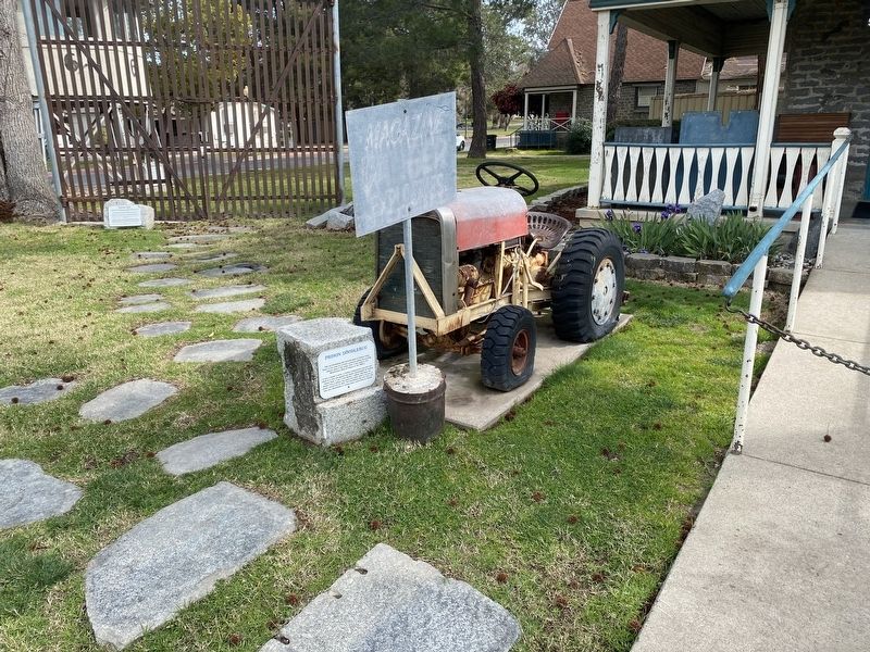
On Prison Road, on the right when traveling north.
This old Doodlebug was manufactured at Folsom State
Prison to be used as a sturdy, powerful pulling and pushing
vehicle, used in the Lower Yard. It was made in the
Maintenance Shop of Folsom
1940's.
It has a model A motor, a military . . . — — Map (db m193059) HM
On Prison Road, on the right when traveling north.
A locomotive was purchased to be used on a short line railroad which had been constructed from the prison to the village of Folsom, for hauling supplies. In the
early part of June, 1893.
In 1922, the walls around the prison were finally . . . — — Map (db m193061) HM
On Prison Road, on the right when traveling north.
This Tree Stump Hitching Post was blasted
loose with dynamite, quarried out, then cut
and shaped into the Tree Stump Hitching
Post by prisoners working in the quarry in
the early years of Folsom Prison. The Tree
Stump Hitching Post was moved to . . . — — Map (db m193062) HM
Since statehood, the people of California have sought and cherished a quality of life unsurpassed in this great nation. There have been among us those who chose to serve as peace officers and when called upon unselfishly gave more than we have the . . . — — Map (db m14814) HM
In the street, at the corner of Fourth and J,
on Aug. 14, 1850, settlers were confronted
by the Mayor and the Sheriff. The fatalities
that day and the next ended
THE SQUATTERS RIOTS
[Column 1]
Hardin Bigelow, Mayor
J. W. . . . — — Map (db m14806) HM
On Panoche Road east of Route 25, on the right when traveling east.
The Downfall of Tiburcio Vasquez began here in what was at that time the Monterey County hamlet of Tres Pinos at about 7 p.m. on August 26, 1873, when the notorious outlaw and six others arrived to rob Andrew Snyder's store.
But first, they . . . — — Map (db m229357) HM
On Aqueduct Road (California Route 62) 0.1 miles west of Parker Dam Road, on the right when traveling east.
Wyatt Earp was born in Illinois March 19, 1848. In 1864 he came west with his family, settling near San Bernardino. He later served as lawman in Wichita and Dodge City, then came to Tombstone in 1879. After the gunfight at the O.K. Corral in 1881, . . . — — Map (db m78569) HM
Near Highland Avenue 0.4 miles east of Victoria Avenue, on the left when traveling east.
Established to honor those men and women who have lived, worked and
received treatment at this institution; and to reflect on the significant role it has
played in the advancement of psychiatric treatment in California.
Through this museum . . . — — Map (db m197718) HM
What is it?
William F. Keys carved and erected the stone to mark the site of a deadly shoot-out. After the May 11, 1943 gunfight, described by Keys as an ambush, Worth Bagley lay dead and the dispute between the two over access to water . . . — — Map (db m150910) HM
After several decades, the infamous, two cell, metal jail is in its original home near the Kelso Depot Visitor Center in Mojave National Preserve. Twelve years ago, officials at the Barstow office of the Health Department wanted it removed from . . . — — Map (db m82386) HM
On Adobe Road just south of Gorgonio Drive, on the left when traveling north.
His real name was Orville Jackson Cones, but some folks around here just called him "Cactus Jack". They say he could make a tin can "dance in the sand" with his six shooter. In 1929 he and his wife Clara homesteaded in 29 Palms and in 1932 he . . . — — Map (db m165754) HM
On Ocean Front Walk, on the left when traveling south.
One spring afternoon in 1913, thousands of sunbathers were enjoying the waters off San Diego when a powerful rip current suddenly swept more than sixty people out to sea. Despite heroic
attempts by police, thirteen people drowned. This tragic . . . — — Map (db m240990) HM
On the 18th of September, 1852,
James "Yankee Jim" Robinson was the
last man to be hanged at this site after
being convicted of grand larceny.
The simple gallows consisted of two posts, a horizontal
beam, and a mule-drawn wagon. . . . — — Map (db m296375) HM
Constructed and completed before the house,
this brick courtroom was originally built to be a
granary. Through the years, it has served as an
Sunday school, a billiard hall, a ballroom, and
from 1869 to 1871 it served as the County of . . . — — Map (db m296377) HM
On Sunday, May 5, 1918, 13 lives were lost here, including 11 soldiers and sailors stationed at Camp Kearny North Island and Point Loma. The rip currents were caused by unusual conditions of tides near the entrance to Mission Bay. Police Lifeguard . . . — — Map (db m212933) HM
On State Highway 79, on the left when traveling north.
Theodore L. Newton, Jr.
July 30, 1941 – June 17, 1967
George F. Azrak
June 30, 1945 – June 17, 1967
During the early morning hours of June 17, 1967, U.S. Border Patrol Inspectors Theodore L. Newton and George F. Azrak were . . . — — Map (db m234142) HM
"He took his chance"
On April 27, 1936, a guard tower stood on these concrete pylons. As officers watched, inmate Joseph Bowers burned garbage in the incinerator straight ahead. Suddenly, Bowers went for the fence, made it over the top, and . . . — — Map (db m193975) HM
During the Civil War, Confederate sympathizers, political prisoners, deserters, and other army convicts were sent to Alcatraz. This marked the beginning of the island's evolution from fort to prison. After the war's end, the post was pressed to take . . . — — Map (db m195490) HM
Alcatraz's executive mansion
For many years, Alcatraz's most powerful resident lived in
a Victorian cottage on Officers' Row. That changed in 1921
when this 15-room mansion was completed. Built on the
island's summit to command respect, . . . — — Map (db m191924) HM
On Steuart Street near Mission Street, on the right when traveling north.
In memory of Howard Sperry and Nick Bordoise, who gave their lives on Bloody Thursday, July 5, 1934, so that all working people might enjoy a greater measure of dignity and security.
Sperry and Bordoise were fatally shot by San Francisco . . . — — Map (db m26162) HM
On Fillmore Street at Fillmore Street, on the right when traveling south on Fillmore Street.
On this site the Haight-Fillmore Building was built in 1886, and the DRUGS sign on the corner dates back to this time. This corner remained
a drugstore until September 1977, when Thomas and Helen Lennihan, a stubborn Irish couple, finally
hung . . . — — Map (db m191085) HM
Near The Embarcadero south of Bay Street, on the right when traveling north.
An Evolving Prison System
World history is replete with forms of corporal punishment such as maiming and even death for slight infractions of the law. In the late 1700s, the United States began to adopt a system based on the Quaker philosophy . . . — — Map (db m228581) HM
Near The Embarcadero south of Bay Street, on the right when traveling north.
In 1907, the War Department drew up plans for a new prison building that could house up to 600 Army prisoners. When finished in 1912, the cellhouse was reportedly the largest steel-reinforced concrete building in the world.
Unskilled Army inmates . . . — — Map (db m228663) HM
Near The Embarcadero south of Bay Street, on the right when traveling north.
The original dock was completed in 1854, and has been modified and enlarged several times since then. The large four-story building immediately behind the dock was once a military barracks. Its ground floor was built between 1865 and 1867. Designed . . . — — Map (db m228661) HM
On The Embarcadero south of Bay Street, on the right when traveling north.
The original dock was completed in 1854, and has been modified and enlarged several times since then. The large four-story building immediately behind the dock was once a military barracks. Its ground floor was built between 1865 and 1867. Designed . . . — — Map (db m228677) HM
One August evening in 1966, transgender women and gay men banded together to fight back against oppression after a police officer harassed one of them at Gene Compton's Cafeteria. This confrontation was the first known full-scale riot for . . . — — Map (db m90982) HM
Here marks the site of Gene Compton's Cafeteria where a riot took place one August night when transgender women and gay men stood up for their rights and fought against police brutality, poverty, oppression and discrimination in the Tenderloin. . . . — — Map (db m91015) HM
Jane Warner spent two decades keeping the peace in the city's Castro, Noe Valley and Mission neighborhoods as a San Francisco Patrol Special Police Officer. To her many friends, she was simply known as "Officer Jane".
She was dedicated not only . . . — — Map (db m64229) HM
On State Highway 88 at Mackville Road, on the right when traveling west on State Highway 88.
"David S. Terry sold Charles Clements the ranch in 1871 where Clements now stands. Terry, Texas Ranger, 49er, California Supreme Court Justice and Confederate General became in 1888 husband and attorney for Sarah Hill, "The Rose of Sharon". In a . . . — — Map (db m151211) HM
On South Locust Avene north of 1st Street, on the right when traveling south.
This jail was constructed in 1925 and used by Ripon’s Constable John Garrison and the county sheriff, Stockton Architect Ralph P. Morrell designed the jail. Ripon contractor L. Ubels built the jail for $2,498.00. The jail was originally erected on a . . . — — Map (db m224858) HM
On East Le Point Street west of Miller Way, on the right when traveling west.
The small Arroyo Grande jail was nicknamed the 'Hoosegow' by members of the community. Derived from the Spanish language, the term 'hoosegow' found its origin around 1865.
Built by the County of San Luis Obispo, the jail was intended for . . . — — Map (db m314048) HM
Near Riverside Ave. 0.1 miles south of 21st Street/Gregory Street.
By the mid-1880s, the population of Paso Robles had increased to a level where a dedicated building to house criminals was needed. On September 20, 1887, Paso Robles Leaderran a story about a Saturday-night drunken brawl where weapons were . . . — — Map (db m72629) HM
Near Mission Road south of El Camino Real ( Highway 82), on the right when traveling south.
Historical Site
1883 – 1924
Adjacent to this site stood “Cavalli’s Blacksmith Shop” which served the truck farmers in the area.
Joe Cavalli
1883 – 1946
Joe was the first and last sheriff of Lawndale (1924 . . . — — Map (db m29134) HM
United States Senator David C. Broderick and California Chief Justice David S. Terry
fought a duel on this ground in the early morning of Tuesday September 13, 1859.
Broderick's firearm discharged prematurely into the ground forcing him to . . . — — Map (db m245993) HM
Near Mori Point Road 0.1 miles west of Cabrillo Highway (State Highway 1).
In the late 1800s, Stefano Mori and his family arrived from Italy and farmed this land, grazing cattle and horses. They built a rambling 21-room farmhouse. This building became Mori's Point Inn, a haven for travelers, bootleggers and diners. Mori's . . . — — Map (db m155296) HM
On Hamilton Street, on the right when traveling north.
A classic example of early "Steamboat Gothic" architecture erected in 1863 as the residence of San Mateo County's first Clerk, Recorder and Assessor, Benjamin G. Lathrop. Later the residence of General Patrick Edward Connor and Sheriff Joel . . . — — Map (db m202539) HM
On Skyline Boulevard (California Route 35), on the right when traveling south.
In the early morning darkness on August 5, 1959, near the intersection of Skyline Blvd. and Bunker Hill Drive Hillsborough Officer Doran Stopped a 19 year old convicted felon who was on probation for burglary and interstate auto theft. The felon was . . . — — Map (db m202462) HM
Santa Barbara County Courthouse has been designated a National Historic Landmark. This courthouse complex possesses national
significance in commemorating the history of the
United States Of America
The Santa Barbara County Courthouse . . . — — Map (db m135167) HM
Skeels Hotel built on the NW corner of 3rd St. and Monterey Rd.; Lloyd Skeels becomes constable and later fire chief of Morgan Hill and Madrone — — Map (db m213568) HM
On Eunice Avenue at Porterfield Court on Eunice Avenue.
This eighteen room farmhouse was built by Nicholas Kristmas in 1924. By 1928, it had entered into an era of local infamy during which it was known alternatively by the names Blue and Gold Kennel Club, Whitehall Distillery, and Burton's Gold Medal . . . — — Map (db m150657) HM
Here lies Captain Harry Love, who with a troop of twenty others, on July 25, 1853 allegedly killed bandits Joaquin Murrieta and Three Fingered Jack near Arroyo de Cantua, Fresno County, California.
Born in Vermont, Love first visited Alta . . . — — Map (db m24122) HM
On Center Street east of Cabrillo Highway ( Highway 1), on the left when traveling east.
uilt in 1914, the entire structure is made of Santa Cruz Portland Cement from the nearby Davenport Cement Plant. During its history, the two-cell jail saw little use in this peaceful community.
It once held two boys from San Mateo while they . . . — — Map (db m100921) HM
On Freeman Street east of Howard Street, on the right when traveling east.
The site of this County jail dates back to 1910, when a small holding cell was used as a drunk tank for local offenders. The current building was reconstructed under the Works Progress Administration in 1936 and continued in use until the 1950s. — — Map (db m176561) HM
On Commercial Street (State Highway 49) south of Main Street, on the left when traveling east.
The Spanish woman also known as Josefa, was hung off the Jersey Bridge July 5, 1851 a short distance down stream from this spot, for the murder of Frederick Alexander Agustus Cannon.
Cannon and his friends were celebrating Independence Day and . . . — — Map (db m57382) HM
On Main Street east of Commercial Street, on the right when traveling east.
Also known as Juanita or Josefa Loaiza, was a Mexican-American woman who was
executed by hanging in Downieville, California, on July 5, 1851. She was found
guilty of murdering a local miner, Frederick Cannon. She is known to be the first and . . . — — Map (db m282479) HM
This house was built by H.A. Green in 1847. Here John H. Nash was taken prisoner by Lieut. William T. Sherman in July 1847 for refusing to relinquish his post as Alcalde to Lilburn W. Boggs. It was restored in 1931 by Zolita Bates, Great . . . — — Map (db m15261) HM
Near Old Winery Road east of Lovall Valley Road, on the left when traveling east.
Marker One:
Hidden within our maze are several private spaces; you may walk along our circuitous paths to find them. Inside these private spaces are signposts describing the astonishing life and journeys of Count Agoston Haraszthy, who . . . — — Map (db m231511) HM
On G Street at 10th Street, on the right when traveling east on G Street.
The Modesto Police will forever be linked to American Graffiti through the most famous scene in the movie. Curt, the film’s protagonist, as a punishment from the notorious car club “The Pharaohs” (The Faros in real life) for scratching the . . . — — Map (db m225303) HM
On G Street at 10th Street, on the right when traveling east on G Street.
Dedicated on the 20th day of June 2000, the new headquarters for the Modesto Police Department is named in memory of Chief Gerald L. McKinsey, who served as a law enforcement officer for 37 years. He was the Chief of Police for the Modesto Police . . . — — Map (db m223771) HM
On Main Street at Kern Street, on the right when traveling north on Main Street.
No one has greater love than this,
To lay down one’s life for one’s friends.
Corporal Ronil Singh
Born April 6, 1985
EOW December 26, 2018
Loving Husband, Father, Son, Brother and Friend
Born in Navua, Fiji Islands, Ronil legally . . . — — Map (db m208388) HM
On Main Street at Tulare Street, on the right when traveling south on Main Street.
In 1886 the Lodge was organized in Hills Ferry. They moved to Newman in 1910 to the newly constructed 3 story building. Street level retail space, 2nd floor meeting rooms and 3rd floor the social hall. Knights of Pythias referred to their lodges as . . . — — Map (db m208394) HM
Deputy Sheriff Charles Wm. "Bud" Carpenter was a life long resident of Trinity County. He was killed in the line of duty while attempting to capture three suspects fleeing from a robbery of the store and post office in Willow Creek.
In his . . . — — Map (db m32632) HM
On North Park Drive north of East Howard Avenue, on the right when traveling north.
In the evening of Friday February 22, 1889, two men wearing masks boarded the engine of Train No. 17 as it pulled away from Pixley Station. At gun point they ordered engineer Peter Bolenger and fireman C.G. Elder to stop the train two miles south . . . — — Map (db m141756) HM
On West Mill Street at North Main Street, on the right when traveling east on West Mill Street.
Jim McKinney, Porterville's "Jekyll and Hyde,” a soft-
spoken man was liked by many, but when drunk was dangerous, always armed and looking for trouble. On the night of July 27, 1902, on a drunken rampage he went totally bad and shot up . . . — — Map (db m141829) HM
On North Santa Fe Street just east of East Center Avenue, on the right when traveling north.
On Christmas Eve 1872 James G. McCrory, who had murdered before in Visalia and in Arizona, was drunk and disorderly at the El Dorado Saloon on Main Street in Visalia. When one of the owners, Charles Allen, tried to quiet him he shot Allen three . . . — — Map (db m141814) HM
On Main Street west of Smoke Street, on the right when traveling west.
Built circa 1910 as Klein and Baum commercial building. Purchased by County of Tuolumne in 1955, by Resolution 39 of Board of Supervisors, Kerr, Dondero Millard, Nicholls and Williams, “for use as a Justice Court and other public purposes.” . . . — — Map (db m301039) HM
On North Washington St. (State Highway 49) at Elkins Street, on the right when traveling north on North Washington St..
The corner property was originally called Patrick’s Corner, after George Washington Patrick, an early settler of Sonora and one of its first mayors. At the outbreak of the Civil War in 1861, Patrick left Sonora to volunteer his services to the . . . — — Map (db m6968) HM
On Poli Street at North California Street, on the right when traveling west on Poli Street.
This imposing building was designed by Albert C. Martin and built in 1912 as the Ventura County Court House. It is an outstanding example of neo-classic architecture, considered the proper style for public buildings of the early 20th century. The . . . — — Map (db m154494) HM
On Ross Avenue south of 8th Street, on the right when traveling south.
The SPMDTU was founded on November 26, 1900, and is the oldest Hispanic civil rights organization in the United States. It was founded in Antonito, by Celedonio Mondragón and six others to fight discrimination in the fields, in the mining . . . — — Map (db m281520) HM
On Ross Avenue south of 8th Street, on the right when traveling south.
[left panel] This is the site of the late “Mexican School” where Hispano-American students were forced to attend, separate from whites, despite being US citizens and being proficient in English. It is also here where Hispano . . . — — Map (db m281521) HM
Alfred Packer was born on January 21, 1842, in Allegheny County, Pennsylvania. He served in the Union Army during the Civil War and was discharged in June 1863 for epilepsy. Packer traveled to the Rockies and worked for the mines for 9 years. In . . . — — Map (db m182105) HM
On U.S. 24 at West Main Street, on the right when traveling south on U.S. 24.
The Ute People made this land home. Next came Spanish military expeditions and French fur trappers. The fledgling U.S. sent its own explorers west into the Rocky Mountains in the early 1800s. In 1806 the Zebulan Pike expedition explored the Buena . . . — — Map (db m293270) HM
Near U.S. 285 just north of U.S. 50, on the right when traveling south.
The Top of the Rockies Scenic and Historic Byway travels through spectacular scenery and is surrounded by some of the state’s highest peaks. In the nineteenth century, these mountains yielded some of Colorado’s biggest mining fortunes. On the . . . — — Map (db m281215) HM
On County Road 24 0.8 miles south of County Road Y, on the right when traveling east.
Near here, on the banks of the Conejos River, Zebulon M. Pike built a log stockade in early February, 1807, and for the first time raised an American flag over what is now Colorado. Pike's trek of 1806-07 was the second official United States . . . — — Map (db m22701) HM
On U.S. 160 at milepost 262.2, 3.9 miles east of Miranda Avenue (State Highway 159), on the left when traveling east.
Western expansion and the need to keep peace between settlers and indigenous people fueled the need for frontier forts. Fort Garland was established in 1858, replacing the earlier Fort Massachusetts, just six miles to the north. Five of the . . . — — Map (db m295462) HM
On Main Street (State Highway 159) just south of Archie Street, on the left when traveling south.
Located within the National Historic Landmark District of La Plaza de San Luís De La Culebra Listed to the National Register of Historic Places on December 22nd, 1978 — — Map (db m294294) HM
Near East 3rd Street at Riley Lane, on the left when traveling east.
The Delta Bank Robbery On or about August 20, 1893, the McCarty Gang arrived in the Delta area and set up camp in Escalante Canyon. Tom McCarty, his brother Bill, and Bill's 20 year old son, Fred, had probably departed from the . . . — — Map (db m290986) HM
This property has been placed on the National Register of Historic Places by the United States Department of the Interior.
City and County of Denver Landmark No. 65 - 1974.
Landmark Preservation Commission. — — Map (db m255060) HM
"Stand up you man-eatin' son of a
bitch, stand up. They wuz seven
Demmy-crats in Hinsdale County, and
you et five of 'em. I sentence you to
be hanged by the neck until you are
dead, dead, dead."
Attributed to Judge Gerry . . . — — Map (db m255447) HM
Famous Hole in the Wall Gang
outlaw Butch Cassidy robbed his
first bank in the box canyon town of
Telluride, Colorado on June 24, 1889.
Cassidy and three others made off
with $20,000 from the San Miguel
Valley Bank and were
never . . . — — Map (db m255445) HM
On Larimer Street 0.1 miles west of 14th Street, on the left when traveling west.
Lynching in America.
Racial terror lynchings between 1877 and 1950 claimed the lives of thousands of Black people and terrorized millions more who were denied equal protection under the law. After the Civil War, white resistance to equal . . . — — Map (db m236319) HM
Near 17th Street just west of Larimer Street, on the right when traveling south.
The first man to rob the Denver Mint was “Small Bad Jim” – James Clark. The gold bars were so heavy that he began dropping them only one mile away in what is now Cheesman Park. Six days later, the desperado was captured 25 miles south of Colorado . . . — — Map (db m100808) HM
On State Highway 145 0.8 miles south of West King Street, on the right when traveling south.
The need for a cemetery in Rico came about with the murder of Julius “Frenchy” Burgen on August 31, 1879, by George “The Kid” McGoldric. Rico’s earliest recorded mine fatality was on February 3, 1881, when Fred Herman was overcome by bad air in . . . — — Map (db m282998) HM
On 4th Street at Perry Street, on the right when traveling east on 4th Street. Reported permanently removed.
This is the original courthouse for the newly formed county. The original two story building started to sway and so the addition was built on to stabilize the structure. It was located on the corner of 4th and Wilcox. — — Map (db m306721) HM
On Main Street just west of North 6th Street, on the right when traveling west.
In 1868 Cañon City residents began building a penitentiary for the Colorado Territory. The 40-cell prison opened to receive convicts in June 1871. By 1899, the penitentiary housed about 400 inmates. Before a wall was built around the prison, . . . — — Map (db m281694) HM
On South 3rd Street 0.1 miles south of Royal Gorge Boulevard (U.S. 50), on the right when traveling south.
Railroads have been essential to the growth of Cañon City. Trains brought people and materials into the region and carried local products to market. Most importantly, the railroads supported the mining industry. Worth Fighting Over . . . — — Map (db m281899) HM
The Colorado State Penitentiary, "Old Max," opened in 1871 as part of the federal prison system when Colorado was still a territory. It was built by convicts using stone quarried and cut on-site. In 1876 when Colorado achieved statehood, " Old Max" . . . — — Map (db m141395) HM
On North 5th Street just south of Macon Avenue, on the right when traveling south.
General Jos. H. Maupin (1856-1929) was responsible for construction of this building — done in two phases from 1903-1907. His name is inscribed at the northeast corner along with another inscription just above — “The Post Office Block.” The Post . . . — — Map (db m281697) HM
On South 4th Street 0.2 miles south of Highland Avenue, on the right when traveling south.
Built in 1906 with native stone, the Prospect Heights jail was the only municipal building in town. It was constructed to incarcerate disorderly people who frequented the numerous area saloons. In response to a 1901 law suspending all liquor . . . — — Map (db m281700) HM
On U.S. 50 0.2 miles east of Phantom Canyon Road (County Road 67), on the right when traveling west. Reported damaged.
When Colorado Territorial Prison opened in June 1871 just west of Cañon City, it drew a mixed reception from law-abiding locals — some daunted by the possibility of felons on the loose, others eager for the jobs and services that came with the . . . — — Map (db m152997) HM
Near Zerex Street (U.S. 40) at Clayton Avenue, on the right when traveling north.
A few hours after Sheriff Billy Cozen's wife had given birth to their first child, he apprehended two bank robbers. Gilpin County afforded no jail yet, so Billy took the suspects home and chained them — against his wife's protest — to the bed where . . . — — Map (db m288497) HM
Near Byers Avenue (U.S. 40) at 1st Street, on the right when traveling east.
This building was built in Sulphur on the northwest side of the town facing south. It was first used by C.H. Hook as a general store. After years of being used for many other purposes, it became the courthouse in 1888 through 1902. In 1937 it was . . . — — Map (db m288899) HM
Near Byers Avenue (U.S. 40) at 1st Street, on the right when traveling east.
This building was built specifically for law enforcement purposes and is the oldest incarceration building still existing in Grand County. Previous jails were “cells” constructed within buildings that were used for other purposes. It was first . . . — — Map (db m289066) HM
On April 6, 1883, the trial for Alferd Packer began at the Hinsdale County Courthouse. This trial was for the murder of Israel Swan. On April 13, 1883, Packer was found guilty by a jury and received a death sentence. Packer's First . . . — — Map (db m291799) HM
On 3rd Street just west of Silver Street, on the right when traveling west.
After being acquired for public offices in 2000, succeeding layers of stucco and clapboard siding were removed from the exterior of the historic Hughes cabin to reveal hand-hewn log beams of the original small, one-room structure which is now . . . — — Map (db m292099) HM
Near Silver Street at 2nd Street (County Road 20), on the right when traveling north.
At its completion in January, 1893, Hinsdale County's new jail was heralded as “one of the handsomest and most substantial jail buildings in this part of the state.” The Lake City TIMES also went on to report that at opening, “the new jail is . . . — — Map (db m292591) HM
Near West 12th Street just west of Camino Del Rio (U.S. 550).
“Resolve that the Mayor instruct the City Marshall to stop all fancy women from riding on horseback or in open carriages or otherwise exhibiting or advertising their occupation on the streets of the City of Durango.” . . . — — Map (db m291496) HM
On County Road 43F, on the left when traveling north.
Established in 1862 by Overland Stage Agent Joseph A. (Jack) Slade. The
stage station may have been named after Slade's wife, Virginia. The
bullet-riddled station served as a refuge from Indian attacks for travelers and local residents. Slade . . . — — Map (db m287069) HM
On North Commercial Street just north of Church Street, on the right when traveling south.
The flat-topped mountain visible between the buildings, looking south on Commercial Street, was an important landmark for wagon trains on the Mountain Route of the Santa Fe Trail. This landmark guided them to the foot of Raton Pass over which . . . — — Map (db m280781) HM
2946 entries matched your criteria. Entries 201 through 300 are listed above. ⊲ Previous 100 — Next 100 ⊳